INTENSE COASTAL SEDIMENTATION AND EROSION IN THE CANANÉIA OUTLET,
SOUTHERN STATE OF SAO PAULO, BRAZIL
Kenitiro SUGUI01
&
Moysés Gonsalez TESSLER21 Instituto de Geociências da Universidade de são Paulo
2 Instituto Oceanográfico da Universidade de são Paulo
Synopsis
The extreme mobility of submerged sand bars at the mouth of the Cananéia outlet
has made safe access diificult to the lagoonal region of Cananéia~ on the southern
coast of the State of Sao Paulo. This problem is serious enough to have been treated by various authors over the past thirty years. Erosional and depositional
processes in the area are the result of the combined~ very often conflicting action
of tidal currents~ waves~ and longshore currents that are active in the dispersal
of the sand sediments o Thus~ at the time that processes of accelerated
sedimen-tation occur at the mouth of the outlet~ intensive erosional phenomena act upon
neighboring salient f eatures of the coastline~ such as Ponta do Perigo on Ilha do
Cardoso and Ponta da Trincheira on Ilha Comprida. Compara tive analysis of aerial photographs taken in 1962 and 1973 and of some bathymetric profiles allowed us to evaluate the evolution of the erosional process on the eastern side of Ilha do Cardoso during this period interval and to determine the growth tendency of the sand bars in the Cananéia outlet.
De scriptors: Sedirnent transport , Coa~tal eros i on , Sediment-water interface, Canané i a ou tl e t (S P) . Ouaternary period.
Descritore s : Transpor t e de sedirnento, Ernsão das cost a s , InterFac e se di~ent()-ãaua. Barra de Can anéia ( SP ) . Período quaternári o .
Introduction
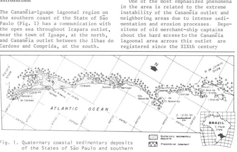
The Cananeia-Iguape lagoonal region on the southern coast of the State of são Paulo (Fig. 1) has a co~unication with the open sea throughout I capara outlet, near the town of Iguape, at the north, and Cananeia outlet between thc Ilhas do Cardoso and Comprida, at the south.
", \
j
One of the most emphasized phenomena in the area is related to the extreme instability of the Cananeia outlet and neighboring areas due to intense sedi-mentation and erosion processes o
Depo-sitons of old merchant-ship capta i ns about the hard access to the Cananeia lagoonal area across this outlet are registered since the XIXth century
EETI
Fig. I. Quaternary coastal sedimentary deposits
of the States of são Paulo and southern ~ Pr.combrion bosement
72
(GEOBRÃS, 1966). This difficu1ty has been attributed to the extreme mobi1ity of submerged sand bars.
..,-.1'
.~----~----~----~~!~.
I.
,...,.
Trl ... ".lr.-:---...L....J
".,..
...
Fig. 2a. Schematic map of the Cananéia out1et region
i n 1 93 8 ( Ma p n. 1 7 O 2
- DHN - 1 938) (Pe t r i
& Suguio, 1971)
~_"tol
•• Triltclo.i,...
..
,
...
Fig.
2b.
Schematic map of the Cananéia out1et regionin 1954 - aeria1 photographs (Petri &
Suguio, 1971). According to Sadowsky (1954) the eastern edge of the Ilha do Cardoso has been subjected to erosiona1 processes for long time, as a consequence, pushing back continuous1y westward the Ponta do perigo. Thus, the southern extremity of the ilha Comprida is being progressive1y invaded by the sea, inf1uenced by strong winds coming dominant1y from the
southern quadrant.
Petri & Suguio (1971) returned to the question using informations from aeria1 photographs and fie1d surveys (Fig. 2a, b),
and as Sadowsky (op. c.-U:..) , they admitted
Bo1m Inst. oceanogr., S Paulo, 32(1),1983
a dominance of coas tal sedimentation processes though loca11y winds and tida1 currents cou1d rapid1y erode 1ess re-sistent edges of the sandy is1an0s •
Cananéia outlet bathymetric pro files
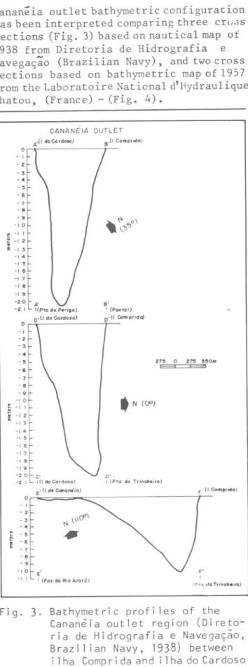
Cananeia out1et bathymetric configurat:ion has been interpreted comparing three crl.3S sections (Fig. 3) based on nautica1 map of 1938 from Diretoria de Hidrografia e Navegação (Brazilian Navy), and two cross sections based on bathymetric map of 1957 from the Laboratoire National d'liydrau1ique Chatou, (France) - (Fig. 4).
o -/ - 2 - 3 - 4 -~ - 6 - 7 -
.
- 9 -/ o~ -/ -, 2
,
E -, 3 -/4
-
,
5 -/ 6-,
7 -, 8-, 9
-2 o -2 ,
o -/ -2 -3 - 4 - 5 -6 - 7 - 8 - 9
-, o
f -/ /
i
-, 2 -, 3 -, 4 -, 5 -, 6 -/ 7 -/ 8 -, 9 -2 o -2 ,o
,
2 - 3 - 4
.
- 5i - 6 - 7 - 8 - 9
-, o
-,
,
CANANEIA OUTLET
A,(I.d4C<JrdMO)
A' s'
I(Pto do Perigo) I (Pontol)
... c._(J_.do_c_or_do_.o_' _ _ ~O_.(/_ ' Cc:mtprida"l
• N {O"J
C· o'
I (/ do Cardoso) I (Pfo do Trincfteiro)
E ·(l. d~ Canane'ia) F' (I. Comprido)
r-~==--~ --- ~
E'
I (Foz do Rio Arot6)
F' ,
( Pro d ClTrinotleira)
Two cross sections between ilha do of submerged sand bars at the Cananéia Cardoso and ilha Comprida, both in 1938 outlet, visible in 1973 aerial
p~oto-as well p~oto-as on 1957 maps, have indicated graphs, could be related to the sediments the occurrence of a circulation channel eroded from the eastern edge of ilha do in the center, whith shallower areas Cardoso.
running along the border of the islands. Northeastward longshore currents must The channel depth has not been practically be assumed according to previous works changed between 1938 and 1957. According on ilha Comprida (Barcelos ~ al., 1976,
to XIXth century documents (GEOBRÃS, Suguio & Martin, 1978) which havedemon-1966) this channel has continued strated a former lengthening phase and a unchanged for a still longer time. latter widening episode during the past According to Sadowsky (1952) the Cananéia 3,500 years for the formation of this outlet was about 1,200 m wide and 20 m
deep.
This circulation channel could be related to paleodrainage valley drowned during the Holocene rising sea-level.
Modifications at the Cananéia outlet
The aerial photographs taken in 1973 were analysed stereoscopically (Fig. 5)
in comparison with the Petri & Suguio's (1971) surveys (Figs 2a,
b).
This com-parative study showed very striking differences. The eastern edge of ilha do Cardoso acquired ~ northwestern trend and its extension is passing at western side of Ponta da Trincheira. An aureola,
.
.
,
.,
. , .. '10
! -, I
1 '1 %
."
." ."
.,.
." .,. ."
."
-u Ir
CANA N ElA OUTLET
o 100 ZOO XlO ..
~
barrier island.
Sadowsky (1952; 1954) followed the growth of a sandy island near ilha do Cardoso, which indicated that the source area of the sediments was situated at SSW.
The interaction between the wave generated longshore currents and tidal currents gives rise to circulation of great water masses across the Cananêia outlet. The occurrence of the aureola of submerged sand bars ~n the Cananêia outlet must be related to this compli-cated pattern of water masses circulation in the area. The mobility of these sand bars could be related to local hydro-dynamic processes.
.,
. ,
.,
..
..
,.,
..
.
·' 0
." ."
." ,.
."
. " ,.
,.
' o
CANANE IA OUTLET
74
o
CREEKS
_ _ TRENDS OF THE BEACH RIDGES
/
J~
\. ÓOÓ05o
Cor
I
,~;' TRENDS OF THE SUBMERGED SAND BARS ,~~~ - (emerQed durinQ lo .. tides)
I Km
Bo1m Inst. oceanogr., S Paulo, 32(1),1983
'I ••••
Cananeia outlet
,\
\ \
\
,
\
~~~ ________ ----~~ __ ---;2~004'
\
\ \
\ \ I \ \ \ \ \
\
o o.e I Km
:['.\ PRESENT BEACHES
...
*=====~·...
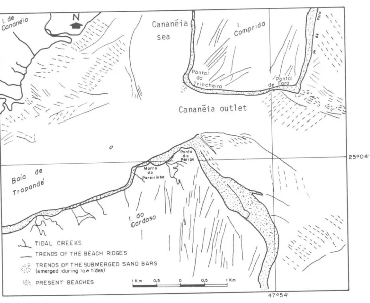
·C===~IFig. 5. Schematic map of the Cananéia out1et region according to aeria1 photographs taken in 1973 0
Conclusions
The comparison of the maps and aerial photographs taken in different years has demonstrated that the eastern edge of Ilha do Cardoso is being subjected to a strong erosion processes due to longshore currents coming from the southeast.
The interaction of the tidal currents and longshore currents is responsible for the sedimentation of submerged sand bars whose mobility could be related to
local hydrodynamic processes.
This type of water covered coas tal area seems to be maintained within an equilibrium profile 50 that the sediments
are accumulated until a maximum aggra-dation level over which they could be eroded and reworked being their products transported to other depocenters.
Resumo
A Barra de acesso
ã
regiao l~gunar de Cananeia-Iguape, na sua porçao mais ao sul (Barra de Cananeia) , possui bancos arenosos submersos, que atraves dos tem-pos tem apresentado extrema mobilidade, dificultando, assim, o acesso de embar-cações a essa região.Processos erosivos e deposicionais a-tuantes nas regiões vizinhas à Barra, conjugadas às ações conflitantes das correntes de mares, ondas e correntes de deriva litorâneas, ocasionam a ativa dis-persão dos sedimentos arenosos.
References
BARCELOS, J. H.; SUGUIO, K. & COIMBRA, A. M. 1976. Sedimentação e sub-am-bientes deposicionais de Ilha Compri-da, são Paulo. XXIX Congresso Brasi-leiro de Geologia, Anais v. 2,:107-135, Ouro Preto, MG.
DIRETORIA DE HIDROGRAFIA E NAVEGAÇÃO. 1938. Carta n'? 1702 (Escala 1: 27.500) , Rio de Janeiro.
GEOBRÁS S/A. 1966. Complexo Valo Grande, Mar Pequeno e Rio Ribeira de Iguape. Relatório Geobrãs S/A, Engenharia e Fundações para o Serviço do Vale do Ribeira, Departamento de Águas e Ener-gia Eletrica do Estado de são Paulo,
2 v.
LABORATOIRE NATIONAL D'HYDRAULIQUE CHATOU. 1957. Levantamento batime-trico da barra de Cananeia, Estado de são Paulo. Mapa batimetrico 1:10.000. Relatório do Departamento de Águas e Energia Eletrica do Estado de são Paulo.
PETRI, S. & SUGUIO, K. 1971. Exemplo do trabalho de mar no litoral sul do Brasil. Notic. geomorfol., 11(21): 61-66.
SADOWSKY, V. 1952. Observações sobre as modificações em curso na entrada de Cananeia, de sua barra e da região adjacente. I. Desgaste das costas. n'? 1. Ponta da Trincheira (1952). Bolm Inst. oceanogr., S Paulo, 3(1/2): 201-212.
1954. Novas
contribui
-çoes ao estudo da entrada da barra de Cananeia. Bolm Inst. oceanogr., S Paulo, 4(1/2):151-177.
SUGUIO, K.
&
MARTIN, L. 19780Qua-ternary marine formations of the State of são Paulo and southern Rio de Ja-neiro. Spec. Publ. tntern. Symp. Coas tal Evolut. Quaternary, S Paulo,
(1) : l-55.