Braz. J. of Develop.,Curitiba, v. 6, n. 7, p. 51493-51515 jul. 2020. ISSN 2525-8761
Analysis of the landscape connectivity: A case study in the Tietê-Jacaré
Hydrographic Basin – SP, Brazil
Análise da conectividade da paisagem: Um estudo de caso na Bacia
Hidrográfica de Tietê-Jacaré - SP, Brasil
DOI:10.34117/ bjdv6n7-698
Recebimento dos originais: 27/06/2020 Aceitação para publicação: 27/07/2020
Diego Peruchi Trevisan Mestre em Ciências Ambientais
Instituição: Universidade Federal de São Carlos
Endereço: Rod. Washington Luiz, s/n, São Carlos - SP, 13565-905 E-mail: [email protected]
Luiz Eduardo Moschini
Doutor em Ecologia de Recursos Naturais Instituição: Universidade Federal de São Carlos
Endereço: Rod. Washington Luiz, s/n, São Carlos - SP, 13565-905 E-mail: [email protected]
ABSTRACT
Research related to urban and hydrological landscapes collaborates with the understanding of natural landscapes through their connections and relationships with the natural environment, contributing to the strengthening of actions aimed at the maintenance of natural, urban, and water ecosystems in the planning actions. This work aims to analyze the interactions between road, hydrological and structural landscape connectivity present in the Tietê-Jacaré Hydrographic Basin - SP, through the application of the Landscape Integration and Connectivity indices, to evaluate the dynamic process of interactions between the landscape compartments in 2007 and 2017. The information was analyzed using Geographic Information Systems, relating the interference and correlations of the road and hydrological space with natural areas on a temporal scale. Considering the 10-year interval, there was an expansion of agricultural activities with a cultivated area increase of 24,507.53ha and vegetation loss of 32,149ha. The hydrographic basin has reduced drainage areas and increased the number of roads that eventually led to changes in connectivity and fragmentation patterns, where urban areas and sugarcane are dominant in these interconnections. This predominance should be observed in more detail regarding the planning of the watershed, especially related to the possible impacts caused by them, where the Landscape Integration and Connectivity indices were presented as essential tools in the diagnosis focused on the conservation of ecosystems. Keywords: Network analysis, Landscape connectivity, Landscape indexes, Environmental planning.
Braz. J. of Develop.,Curitiba, v. 6, n. 7, p. 51493-51515 jul. 2020. ISSN 2525-8761 RESUMO
Pesquisas relacionadas a paisagens urbanas e hidrológicas colaboram com a compreensão das paisagens naturais, por meio de suas conexões e relações com o ambiente natural, contribuindo para o fortalecimento de ações voltadas à manutenção dos ecossistemas naturais, urbanos e hídricos nas ações de planejamento. Este trabalho tem como objetivo analisar as interações entre conectividade rodoviária, hidrológica e estrutural da paisagem presentes na Bacia Hidrográfica de Tietê-Jacaré - SP, por meio da aplicação dos índices de Integração e Conectividade da Paisagem, para avaliar o processo dinâmico de interações entre os compartimentos da paisagem em 2007 e 2017. As informações foram analisadas em Sistemas de Informações Geográficas, relacionando as interferências e correlações da estrada e do espaço hidrológico com as áreas naturais em escala temporal. Considerando o intervalo de 10 anos, houve expansão das atividades agrícolas, com aumento da área cultivada de 24.507,53ha e perda de vegetação de 32.149ha. A bacia hidrográfica reduziu as áreas de drenagem e aumentou o número de estradas que eventualmente levaram a mudanças nos padrões de conectividade e fragmentação, onde as áreas urbanas e a cana-de-açúcar são dominantes nessas interconexões. Essa predominância deve ser observada com mais detalhes no planejamento da bacia hidrográfica, principalmente em relação aos possíveis impactos causados por elas, onde os índices de Integração e Conectividade da Paisagem foram apresentados como importantes ferramentas no diagnóstico voltado à conservação dos ecossistemas.
Palavras-chave: Análise de rede, Conectividade paisagística, Índices paisagísticos, Planeamento ambiental.
1 INTRODUCTION
The landscape structure is the result of interactions between physical, biological, political, economic, and social forces that are characterized by a structure connected or fragmented by land uses. The analysis of the spatial configurations of the landscapes becomes essential concerning the subsidy of studies related to the impacts of anthropic changes on ecosystems, where connectivity establishes the degree of ease that the elements move between the landscape units (GOERL et al., 2011; TURNER; SIMARD, 2017).
The development of methods and indexes aimed at analyzing landscapes is a prerequisite for understanding the relationships of their patterns and organization processes. In the last decades, new quantitative methods have appeared to analyze patterns, determine the importance of spatial processes and develop models, where metrics and indexes are one of the most effective ways to quantify the spatial attributes of landscapes (LI; WU, 2004; MARTINI et al., 2018).
Studies related to urban and hydrological landscapes collaborate with the understanding of natural landscapes through the understanding of their interconnections and interrelations with the natural environment. Such analyzes strengthen and direct actions aimed at maintaining and recovering natural ecosystems and, consequently, urban and water ecosystems in planning actions. For example, the study developed by Oliveira et al., (2014) aimed to map the land cover and to analyze the landscape fragmentation to identify pressure and state indicators to be used in the
Braz. J. of Develop.,Curitiba, v. 6, n. 7, p. 51493-51515 jul. 2020. ISSN 2525-8761
Pressure-State-Response (PER) Model to the Alto São Bartolomeu Hydrographic Basin – DF. It was observed that most of the remaining fragments of native vegetation are under pressure by the agricultural matrix due to the accelerated process of occupation of land use and coverage in its surroundings.
In this way, understand urbanized, hydrological and environmental areas as a complex territory, where social issues interact with biophysical elements, presupposes analyzing not only the ordering and regulation of land use in their different interurban and ecological spaces but also the contextualize its spatial and temporal dimensions, considering the various interactions at its multiple scales (TURNER et al., 1989; TURNER; SIMARD, 2017).
Also, the organization of the road network interferes with hydrological connectivity by modifying the courses of the rivers, receiving runoff from the slopes and directing them to the drainage channels, and consequently, connecting or disconnecting the natural fragments present in the landscape (LANE et al., 2006; XIA, 2017). This process can occur especially in the areas close to the roads, mainly in the points of most significant influence, where there is a direct connection between the roads, the drainage channels, and the forest fragments (CROKE et al., 2005; LAMOUNIER, 2015).
The vegetation has a direct influence on the processes of hydrological connectivity, in addition to the protection and maintenance of the watershed areas. Through the interception of vegetation, the damping of the water impact on the soil and the retention of moisture by the litter, which they delay runoff, decrease erosion processes and enable increased percolation and recomposition of groundwater (VIANA et al., 2009; XIA, 2017).
This context encompasses the importance of adequate territory planning, aiming at improving environmental, hydrological and urban quality, where environmental functionalities are significantly valued, with a growing interest on the effects of human activities on the properties of interaction networks (PICKETT et al., 2001; MOREIRA et al., 2015).
The use of indexes and metrics complemented by Geographic Information Systems (GIS) have facilitated analyzes related to the characterization, diagnosis and environmental and urban planning, assisting in tasks such as the simulation of geographical space and its natural processes and the integration of spatial information (NICOLETTI; FERREIRA, 2015). Drawing on this, this work aims to analyze the interactions between the road, hydrological and structural connectivity of the landscape present in the territory of the Tietê-Jacaré Hydrographic Basin - SP, through the application of Landscape Integration and Connectivity indexes, within order to evaluate the dynamic and temporal process of interactions between connectivities in the years 2007 and 2017.
Braz. J. of Develop.,Curitiba, v. 6, n. 7, p. 51493-51515 jul. 2020. ISSN 2525-8761 2 MATERIAL AND METHODS
2.1 STUDY AREA
The State Laws n.7.663, of 12/30/91 (São Paulo, 1991) and 9.934 of 12/27/1994 (São Paulo, 1994), institute the management of water resources in São Paulo state, which has been carried out through the Water Resources Management Units (WRMU) (CBH-SM, 2015). The state currently has twenty-two (22) WRMU, which were delimited from the concept of a river basin, according to which each unit encompasses the water resources that converge to a mainstream, necessitating a link between research and management.
The Tietê-Jacaré Hydrographic Basin (Figure 1) is São Paulo state, Brazil, between 49º14' and 47º70' west and 21º62' and 22º79' south, with a population of 1,462.855 inhabitants and a total area of 1,181,090 hectares distributed in 37 municipalities. With a drainage area of 8,669.09km, the Tietê-Jacaré Hydrographic Basin contains three main rivers: the Tietê River, the Jacaré-Guaçu River, and the Jacaré-Pepira River. The climate by classification of Köppen-Geiger is between humid tropical climate (from October to March) and dry winter (from April to September) (Tundisi et al., 2008; CBH – TJ, 2017).
Braz. J. of Develop.,Curitiba, v. 6, n. 7, p. 51493-51515 jul. 2020. ISSN 2525-8761
Figure 1: Tietê-Jacaré Hydrographic Basin - SP, Brazil
The main economic activities are related to agroindustry (sugar, alcohol, and citrus processing). In the largest municipalities such as Bauru, São Carlos, Araraquara, and Jaú, other sectors of the industry such as paper, beverages, footwear, and metalworking, also stand out (Tundisi et al., 2008; CBH – TJ, 2017). The region of the Tietê-Jacaré Hydrographic Basin is inserted in the biomes of the Atlantic Forest (23%) and Brazilian Savanna (Cerrado) (77%), considered biodiversity hotspots.
For presenting consolidated development characteristics, which integrate several municipalities with a high degree of urbanization and industrial and agricultural potential, and inserted in essential regions of natural ecosystems, the Tietê-Jacaré Hydrographic Basin becomes a potential area for analyzing the connectivity relationships between the landscape compartments and
Braz. J. of Develop.,Curitiba, v. 6, n. 7, p. 51493-51515 jul. 2020. ISSN 2525-8761
their interrelationships with anthropic development and natural areas, assessing how they influence the conservation of ecosystems (TREVISAN et al., 2020).
2.2 METODOLOGIA
The information was analyzed in Geographic Information Systems (GIS), using the ArcGis 10.5 and DepthMapX 0.5 software (Figure 2). For the landscape characterization, a georeferenced database of the Tietê-Jacaré Hydrographic Basin was prepared in the geographic projection latitude/longitude, datum SIRGAS2000 for the entire information plan. The delimitation of the Tietê-Jacaré Hydrographic Basin was obtained from the digital database of the Brazilian Institute of Geography and Statistics (IBGE), version 2015.
The files were imported into the Geographic Information System, which enabled the analysis and digital processing of the vector file, using the IBGE planialtimetric charts, acquired in an analog form on the 1:50,000 scale (IBGE, 1971). Through the digitalization on-screen, drainage lines were obtained, and the delineation of hydrographic sub-basins was obtained, acquired through the digitalization of territorial limits, determined and directed by the elevations of the land, present in the hypsometric classes.
The road network update for 2007 was carried out based on the 2007 Brazilian Digital Network prepared by IBGE, in the LandSat 5 images of April 21, 2007, and Digital Globe of July 14, 2007, acquired from Google Earth Pro 7.1 software, with 0.5m resolution. For 2017, the update was carried out based on the LandSat 8 image of March 11, 2017, and the World Street Map image of July 14, 2017, with 0.3m resolution.
The update of the drainage network for 2007 was based on the LandSat 5 images of April 21, 2007, and Digital Globe of July 14, 2007, acquired from Google Earth Pro 7.1 software, with 0.5-meter resolution. For 2017, the update was based on the LandSat 8 images of March 11, 2017, the Digital Globe of July 14, 2017, acquired from the Google Earth Pro 7.1 software, with 0.5-meter resolution and the Project of Ecological Restoration of the Permanent Preservation Areas of the Tietê-Jacaré Hydrographic Basin (ATTANASIO et al., 2014).
Braz. J. of Develop.,Curitiba, v. 6, n. 7, p. 51493-51515 jul. 2020. ISSN 2525-8761
Figure 2: Workchart
By visual on-screen digitizing the land use and land cover was based on the multi-level classification system proposed by the Land Use Technical Manual from IBGE (IBGE, 2013). In the primary level, four classes were included that indicate the principal land use categories. The secondary level analyzed the types of land uses that were included in the first level, and the tertiary level explained the land uses themselves (Table 1).
Table 1. Land use and land cover description.
Class (I) Type (II) Description (III)
Anthropogenic and
not agricultural areas Urban areas
Dense urban area and areas with rural developments (industrial and household)
Anthropogenic- agricultural areas
Sugarcane Cultivation area of Saccharum officinarum L.
Citrus Cultivation area of Citrus sinensis.
Pastures An area with a predominance of herbaceous vegetation (native
or exotic), used for extensive livestock farming.
Silviculture Cultivation area of Eucalyptus spp or Pinus spp.
Soil exposed Soil fallow area for Saccharum officinarum L. cultivation
Vegetation Natural
vegetation
An area with a predominance of tree vegetation, with vegetation types of semi-deciduous forest and Cerrado.
Water Water Large rivers, lakes, ponds, and reservoirs.
Braz. J. of Develop.,Curitiba, v. 6, n. 7, p. 51493-51515 jul. 2020. ISSN 2525-8761
The time dynamics of land use and coverage was performed based on the visual classification of LandSat images available on the United States Geological Survey platform (USGS, 2017), dated April 21, 2007, and March 11, 2017. Through the digitalization on screen, a “pixel” was assigned to each class of use. For analysis of land use and land cover in 2017, images from the LandSat 8 satellite - OLI / TIRS sensor, bands 6/5/4, were used, and for 2007, images from the LandSat 5 satellite - TM sensor, bands 5/4/3 were used, referring to the orbits/points 220/75, 220/76, and 221/75, 221/76.
The use of different satellite scenes (USGS, 2017) occurred due to the unavailability of images by a single satellite during the study period, where the images used for this study had the same spatial resolution of 30 meters. The dates were selected according to the work schedule to be carried out, where the periods of March and April, due to the seasonality of the agricultural practices prevalent in the region. The 10-year difference between the images made it possible to study the temporal patterns of the landscape, essential in directing regional planning, which considered the current growth and development aspects.
2.3 INTEGRATION BETWEEN THE TIETÊ-JACARÉ HYDROGRAPHIC BASIN NETWORKS For the analysis of the integration between the networks of the Tietê-Jacaré Hydrographic Basin, the Landscape Integration and Connectivity indexes adapted from McGarigal et al., (1995); Volotão (1998) and Goerl et al., (2011) (Table 2). We sought to relate the interference and correlations of natural areas with the road and hydrological space in a temporal way, analyzed from the information present in the characterization of land use and coverage.
The temporal interrelationships that may have influenced the characteristics present in the landscape were analyzed, guiding possible advances to the setbacks in the conservation of ecosystems in the study area. Several authors have been developing works related to discussions about the influence and impacts of road and hydrological areas on natural ecosystems (DIEGUES, 2007; RESENDE et al., 2011; SCOSS, 2012; CARVALHO; LAMOUNIER, 2015; XIA, 2017), mainly related to the consequences of these changes in natural landscapes.
The study carried out by Scoss (2012) addressed the impacts of roads on terrestrial mammals, were estimated the richness of terrestrial mammal species on the side of the road, in addition to the intensity with which these species use the road and its margins, and how often they are used. The results indicated that the presence of roads alters the use of the area for many species of mammals, forming a gradient of use of the space between the edge of the road up to 152m into the forest.
Braz. J. of Develop.,Curitiba, v. 6, n. 7, p. 51493-51515 jul. 2020. ISSN 2525-8761
In this sense, the analysis of the Drainage Length Index by Class of use and land cover allowed to infer about the environmental legislation that, according to the Brazilian Forest Code, the springs and a riparian forest corridor must be preserved, with a variable length of according to the width of the river, in areas adjacent to watercourses (GOERL et al., 2011). Drainage Density by Class of Fragmentation was also evaluated, which estimated how much the land use and land cover fragments are connected to the drainage network, inferring the degree of hydrological connectivity of the different land use and land cover classes (GOERL et al., 2011).
The index of road contact and fragment by class was determined considering the contact of the perimeter of the fragments on both sides of the roads, enabling the interaction of different uses with the same road segment, demonstrating which uses have the most significant possibility of interacting with the network. roads (GOERL et al., 2011).
Table 2. Indexes for assessing the integration between the structural landscape network with the road and hydrological networks.
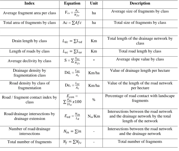
Index Equation Unit Description
Average fragment area per class Fcx =
𝐴𝑐
𝑁𝑓𝑐 ha
Average size of fragments by class
Total area of fragments by class Ac = ∑𝐴𝑓𝑐 ha Total size of fragments by class
Drain length by class 𝐿𝑑𝑐 = ∑𝐿𝑠𝑑 Km Total length of the drainage network by class
Length of roads by class 𝐿𝑒𝑐 = ∑𝐿𝑠𝑒 Km Total road length by class
Average declivity by class S = ∑𝑁𝑆𝑥𝑐
𝑓𝑐 º
Average slope value by class Drainage density by
fragmentation class Ddc =
𝐿𝑑𝑐
𝐴𝑐 Km/ha
Value of drainage length per hectare
Road density by class of
fragmentation Dec =
𝐿𝑠𝑐
𝐴𝑐 Km/ha
Value of the length of the road network per hectare
Road / fragment contact index by class
𝐸𝑐𝑜𝑛 =
∑𝑃𝑒𝑐
2𝐿𝑒𝑥100
% Percentage of road contact with landscape fragments
Road/drainage intersections by
drainage extension 𝐸𝑒𝑑 =
𝑁𝑖𝑛
𝐿𝑑 Nin/Km
Intersections between the road network and the drainage network by the total
length of the network Number of road/drainage
intersections 𝑁𝑖𝑛 = ∑𝑖𝑛 -
Intersections between the road network and the drainage network
Braz. J. of Develop.,Curitiba, v. 6, n. 7, p. 51493-51515 jul. 2020. ISSN 2525-8761
Roads / drainage ratio 𝐸𝑒𝑑 =
𝐿𝑒
𝐿𝑑 Km/Km
Dividing the drainage length by the length of the road network
Source: McGarigal et al., (1995); Volotão (1998) e GOERL et al., (2011)
Ac = area of each class; Afc = area of the class fragment; Lse = length of roads by class; Lec = total length of roads by class; Lsd = length of channel segments by class; Ldc = total length of channels by class; Lse = length of road segments by class; Lec = total length of roads by class; in = intersection between road and drainage; Le = total length of roads; Ld = total drainage length; Nfc = fragments of each class; Sxc = mean slope of the class; Pec = length of contact of the perimeter of the fragments with roads.
3 RESULTS AND DISCUSSIONS
3.1 ROAD NETWORK, DRAINAGE NETWORK AND LAND USE AND COVERAGE OF THE TIETÊ-JACARÉ HYDROGRAPHIC BASIN
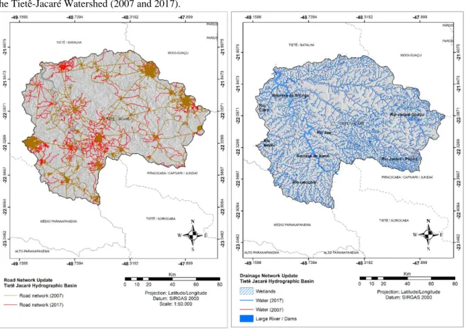
The road network present in the Tietê-Jacaré Hydrographic Basin has a total extension of 13,082.88 km (Figure 3). According to Castro (2008), this road extension expanded mainly between 1870 and 1930, where the territorial occupation process took place in the region, through which the urban network of cities was structured, in addition to consolidating a transport infrastructure with highways, railways, and waterways.
By updating the road network using satellite images, there was an increase from 9,450.43 km in 2007 to 13,082.88 km in 2017, totaling an increase of 38.43%, being observed in all municipalities, especially in the largest cities such as Jaú, Bauru, Araraquara, and São Carlos. This correlates mainly with the expansion of urban areas in the municipalities (according to the data obtained through the analysis of the bear and land cover, in the interval from 2007 to 2017 this growth was 7,832.67ha), with highways and roads were already consolidated since 1971, as noted in the IBGE planialtimetric charts.
Braz. J. of Develop.,Curitiba, v. 6, n. 7, p. 51493-51515 jul. 2020. ISSN 2525-8761
Figure 3: Road network of the Tietê-Jacaré Hydrographic Basin (2007 and 2017). Figure 4: Drainage network of the Tietê-Jacaré Watershed (2007 and 2017).
The drainage network of the Tietê-Jacaré Hydrographic Basin (Figure 4), has a total extension of 8,686.42Km and 23,123.28ha of flooded areas. The Rio Tietê-Jacaré Water Resources Management Unit consists of six main sub-basins, which refer to the six main rivers: Rio Tietê, Rio Claro, Rio Lençóis, Rio Bauru, Jacaré-Guaçu, Jacaré-Pepira and Rio Jaú (COMITÊ PCJ, 2007; CBH-TJ, 2017).
Through the updating of water bodies, a reduction from 8,818.09km to 8,686.42Km was observed from 2007 to 2017, totaling 208.35km (2.34%) of the drainage network, where 163.77km refers to the decrease of springs, with the regions of the sub-basins of Rio Claro 58km), Pepira (-45.86km) and Rio Jacaré-Guaçu (-32.44km) with the most significant losses. This reduction is noticeable throughout the all the region, but in some regions, such as the municipalities of Ribeirão Bonito, Boa Esperança do Sul, Bocaina and Araraquara, these changes are more significant, mainly caused by the advances of human activities over natural regions, which occurred even in tourist-sized municipalities, such as Brotas.
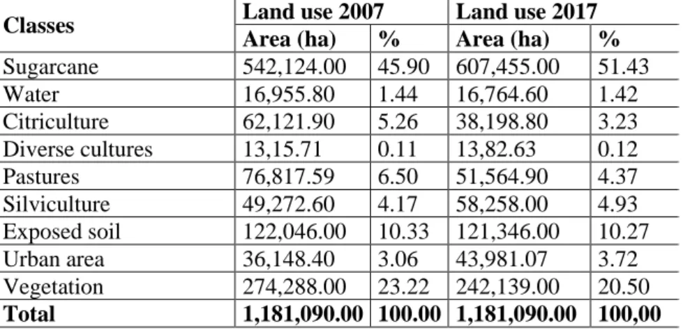
The uses of sugarcane, water, citrus, diverse cultures (by satellite image resolution, some regions such as corn, coffee, and rice were grouped in the same use), pastures, silviculture, and vegetation (Figure 2) were classified. The interval of 10 years showed an expansion of agricultural
Braz. J. of Develop.,Curitiba, v. 6, n. 7, p. 51493-51515 jul. 2020. ISSN 2525-8761
activities with an increase of 24,507.53ha (2.05% of the total area) of cultivated areas, mainly by sugar cane cultivation.
The 10-year time interval is small, considering the total size of the region. However, this change between the landscape land uses explains the consolidation state of the anthropic activities, where regions whose agricultural activities occur are already predefined and delimited. In 2007, approximately 72% of the area showed a predominance of agricultural activities, being 542,114ha occupied by sugarcane, 49,272.60ha by silviculture, 76,817.59ha by pasture, 62,121.90ha by citrus cultivation and 1,315.71ha by diverse cultures (Table 3).
The exposed soil areas are associated with crops (122,046ha), as they refer to the fallow period and soil preparation for the next harvest. Pasture areas arise in small territorial portions, becoming a subsistence or small-scale production activity. Sugar cane is predominant in practically all municipalities, but in some regions, other types of agricultural cultures are predominant, such as citrus cultivation in the Araraquara, Nova Europa, and Gavião Peixoto region, and forestry in the Agudos and Pederneiras and Brotas and Itirapina region.
In 2017, approximately 74% of the area presented the predominance of agricultural activities, being 607,455ha occupied by sugarcane, 58,258ha by silviculture, 51,564.9ha by pastures, 38,198.80ha by citriculture, 1,382.63ha by diverse cultures and 121,346ha by exposed soil. It was observed the growth of 65,331ha of sugarcane crops, where areas of other agricultural uses or soil exposed were converted, contributing to the predominance of this crop in the region.
Braz. J. of Develop.,Curitiba, v. 6, n. 7, p. 51493-51515 jul. 2020. ISSN 2525-8761
Figure 2: Land use and land cover of the Tietê-Jacaré Hydrographic Basin for 2007 and 2017
Urban areas had increased 7,832.67ha (36,148.40ha in 2007 and 43,981.07ha in 2017). This growth was more noticeable in medium to large municipalities, such as Jaú, Bauru, São Carlos and Araraquara, where small municipalities such as Torrinha, Ibaté, and Brotas, still maintain their structures mainly focused on activities related to the agricultural and industrial sector with technical support from the larger municipalities.
Braz. J. of Develop.,Curitiba, v. 6, n. 7, p. 51493-51515 jul. 2020. ISSN 2525-8761
Table 3. Distribution of land use and land cover classes of the Tietê-Jacaré Hydrographic Basin for 2007 and 2017.
Classes Land use 2007 Land use 2017
Area (ha) % Area (ha) %
Sugarcane 542,124.00 45.90 607,455.00 51.43 Water 16,955.80 1.44 16,764.60 1.42 Citriculture 62,121.90 5.26 38,198.80 3.23 Diverse cultures 13,15.71 0.11 13,82.63 0.12 Pastures 76,817.59 6.50 51,564.90 4.37 Silviculture 49,272.60 4.17 58,258.00 4.93 Exposed soil 122,046.00 10.33 121,346.00 10.27 Urban area 36,148.40 3.06 43,981.07 3.72 Vegetation 274,288.00 23.22 242,139.00 20.50 Total 1,181,090.00 100.00 1,181,090.00 100,00
The vegetation is fragmented along the study area, presenting a loss of approximately 2.7% in ten years (32,149ha), and these fragments are immersed in the agricultural matrix and mostly associated with water. A fact that correlates with the reduction of the region's main water masses, with a loss of 191,20ha. The natural remnants are located near the Tietê-Jacaré River, in the municipalities of Itajú, Bariri, Ibitinga, and Bocaina, near the Jacaré-Guaçu River in the municipalities of Ribeirão Bonito, São Carlos, Ibaté and Itirapina, near the Jacaré-Pepira River in the municipalities of Dourado and Brotas and Rio Jaú, in the municipalities of Jaú and Mineiros do Tietê.
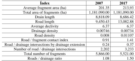
3.2 INTEGRATION BETWEEN THE TIETÊ-JACARÉ HYDROGRAPHIC BASIN NETWORKS Tables 4 and 5 show the integration indicators for the Tietê-Jacaré Hydrographic Basin in the years 2007 and 2017, with 5,866 and 5,521 fragments identified respectively, which have an average area of 201.17 and 213.18ha and an average of 655 and 613 fragments by land use and land cover class.
Braz. J. of Develop.,Curitiba, v. 6, n. 7, p. 51493-51515 jul. 2020. ISSN 2525-8761
Table 4. Indices of integration and connectivity of the landscape of the Tietê-Jacaré Hydrographic Basin in 2007 and 2017.
Índex 2007 2017
Average fragment area (ha) 201.35 213,93
Total area of fragments (ha) 1,181.090.00 1,181,090.00
Drain length 8,818.09 8,686.42
Road length 9,450.43 13,082.88
Average declivity 6.37 6.37
Drainage density 0.00746 0.00734
Road density 0.008 0.01107
Road / fragment contact index 0.91 1.41
Road / drainage intersections by drainage extension 0.24 0.37
Number of road / drainage intersections 2,202 3,233
Total number of fragments 5,866.00 5,521.00
Roads / drainage ratio 1.08 1.50
There was a decrease in the number of fragments (Figure 6), as well as an increase in their average size, an increase in the number of roads and a decrease in the drainage network that is mainly derived from the growth of human activities in the landscape, mainly from agricultural matrices with a consequent decrease in the diversification of fragments of land use and land cover classes, as evidenced in the analysis of temporal dynamics of land use and land cover.
Table 5. Integration and connectivity indexes by the class of use and land cover of the Tietê-Jacaré Hydrographic Basin landscape in 2007 and 2017. Land use/Index AM AT CDC 2007 2017 2007 2017 2007 2017 Urban 187.30 193.75 36,148.40 43,981.07 174.94 216.45 Water 66.49 70.14 16,955.80 16,764.60 321.49 376.34 Vegetation 125.25 108.53 274,288.00 242,139.00 4,215.31 3,862.67 Exposed soil 88.38 125.49 122,046.00 121,346.00 453.72 521.21 Citriculture 381.99 913.56 62,121.90 38,198.80 209.17 122.01 Diverse cultures 263.14 276.53 1,315.71 1,382.63 7.07 7.95 Pasture 250.22 261.75 76,817.59 51,564.90 443.57 310.00 Silviculture 473.78 257.78 49,272.60 58,258.00 189.45 198.36 Sugarcane 407.31 446.33 542,124.00 607,455.00 2,803.37 3,071.43
Land use/Index CEC DM DD
2007 2017 2007 2017 2007 2017 Urban 4,866.60 6,338.65 5.80 5.87 0.0048 0.0049 Water 33.98 40.40 3.85 3.65 0.0190 0.0224 Vegetation 1,265.07 1,427.28 7.69 7.76 0.0154 0.0160 Exposed soil 412.03 637.48 6.56 6.63 0.0037 0.0043 Citriculture 184.11 73.25 6.63 6.66 0.0034 0.0020 Diverse cultures 0.51 2.44 6.44 6.40 0.0054 0.0057
Braz. J. of Develop.,Curitiba, v. 6, n. 7, p. 51493-51515 jul. 2020. ISSN 2525-8761 Pasture 517.34 541.54 6.84 6.91 0.0058 0.0060 Silviculture 141.00 212.14 6.53 7.06 0.0038 0.0034 Sugarcane 2,029.79 3,809.70 6.70 6.80 0.0052 0.0050 Land use/Index DE IC IE 2007 2017 2007 2017 2007 2017 Urban 0.1346 0.1441 25.76 24.24 4.81 4.52 Water 0.0020 0.0024 0.18 0.15 0.07 0.09 Vegetation 0.0046 0.0059 6.70 5.46 0.18 0.28 Exposed soil 0.0034 0.0053 2.18 2.44 0.20 0.20 Citriculture 0.0048 0.0012 0.97 0.28 0.07 0.07 Diverse cultures 0.0004 0.0018 0.00 0.01 0.28 0.25 Pasture 0.0067 0.0105 2.74 2.07 0.23 0.40 Silviculture 0.0029 0.0036 0.75 0.81 0.15 0.17 Sugarcane 0.0037 0.0063 10.72 14.54 0.16 0.28
Land use/Index NI NF R E/D
2007 2017 2007 2017 2007 2017 Urban 842 978 193 227 27.82 29.28 Water 24 32 255 239 0.11 0.11 Vegetation 773 1,092 2,190 2,231 0.30 0.37 Exposed soil 90 102 1.381 967 0.91 1.22 Citriculture 14 9 100 68 0.88 0.60 Diverse cultures 2 2 5 5 0.07 0.31 Pasture 104 123 307 197 1.17 1.75 Silviculture 28 33 104 226 0.74 1.07 Sugarcane 441 862 1,331 1,361 0.72 1.24
AM = average area; AT = total area; CDC = Drain length per class; CEC = Length of roads by class; DM = Average declivity by class; DD = Drainage density by fragmentation class; DE = Road density by class of fragmentation; CI = Road / fragment contact index by class; IE = Road / drainage intersections by drainage extension by class; NI = Number of road / drainage intersections per class; NF = Total number of fragments per class; R E / D = Road / drainage ratio
Through the analysis of the indicator “Average Declivity by Class of Use and land cover,” it was possible to determine the potential capacity of the fragments of each class to connect with the fragments downstream. According to GOERL et al., (2011) this connection can occur mainly through the propagation of surface flow via flow generation mechanisms, as well as the type of matter produced by the upstream fragments, such as, for example, the diffuse transport of pollutants, acid resins, and sediments generated via erosive processes.
Braz. J. of Develop.,Curitiba, v. 6, n. 7, p. 51493-51515 jul. 2020. ISSN 2525-8761
The Tietê-Jacaré hydrographic basin showed an average homogeneous slope over the land use and land cover classes, having, as expected, the areas of water bodies with the lowest rates. This fact indicates an interconnection between the classes of land use and coverage, which implies the different possibilities of impacts or influences of the regions, with each other.
The analysis of the Drainage Length Index by Class made it possible to infer the location of water bodies concerning land uses in the study area. The average drainage length per class was 979 and 962km. However the Vegetation and Sugarcane classes were the main influence classes, with 4,215.31 and 3,862.67Km and 2,803.37 and 3,043.86km in 2007 and 2017, with the variation in values referring to the decrease in the drainage network and fragments of vegetation over the analyzed periods.
The analysis of the Road Length Index by Class was presented as an average of 1,049 and 1,452 km in 2007 and 2017, with the urban area and sugar cane classes as the main ones, with 4,866.60 and 6,338.65km and 2,024.76 and 3,802.44 km respectively. This significant growth refers to the growth of the road network over the years analyzed. It is noted that vegetation areas showed an increase in road values from 1,265.07 to 1,427.28km, which corroborates with later results on the growth of the fragmentation of the natural areas of the watershed landscape.
The “Road/fragment contact by class” index was determined considering the contact of the fragments perimeter on both sides of the roads, enabling the interaction of different uses with the same road segment. This index shows which uses are most likely to interact with the road network. As expected, the urban area showed more significant values, followed by sugar cane and vegetation, with approximately 25 and 24, 7, and 6 and 11 and 15% of interactions.
The classes of vegetation, urban area, and sugarcane also presented the central values referring to the number of interactions between roads and drainage networks, with 773 and 1,092, 842 and 978, and 441 and 862 in 2007 and 2017 respectively. The growth of negative impacts of integrations between the networks, with a decrease in the drainage network, corroborates with the recent discussions about the possible water crisis in the 21st century, related much by the lack of adequate management than by the real crisis of scarcity and stress (ROGERS et al., 2006). However, for other specialists, it is the result of a set of environmental problems aggravated by other problems related to the economy and social development (GLEICK, 2000; PELLENZ et al., 2018).
The progress of the road network over environmental systems corroborates with the information provided by the State of São Paulo State Highway Department (DER, 2019), which shows that the total road network in the state of São Paulo in 1988 was 24,548 km, moving to a projection of 40,000km in 2019, being the largest state road transport system in Brazil.
Braz. J. of Develop.,Curitiba, v. 6, n. 7, p. 51493-51515 jul. 2020. ISSN 2525-8761
This predominance of agricultural activities and mainly sugar cane, coincides with the São Paulo scenario, with the state of São Paulo, more precisely the interior of São Paulo, the largest producer of sugarcane in Brazil. This title is due to the growth of the domestic and foreign market and some favorable conditions for its cultivation, such as, for example, the state with more fertile land that allows higher average productivity than in other regions and the fact of having developed a sector of producing goods for the sugarcane culture (NATALE NETTO, 2007; MARTINI et al., 2018).
The process of alteration and integration of the landscape as analyzed for the entire Tietê-Jacaré Hydrographic Basin was also noted in studies from other regions (SOARES FILHO, 2001; CHAVES; SANTOS, 2009; SILVA et al., 2017), which observed the process of fragmentation of natural areas, integration between fragments, as well as the impacts caused by human activities.
Silva; Souza (2014) aimed to analyze the spatial patterns of forest fragmentation in the Ibura National Forest and its surroundings, in light of the metrics of the landscape. The authors detected an increase in the fragmentation process, warning that it may evolve if connectivity proposals are not implemented. They conclude that the metrics can support proposals for future ecological corridors in the Atlantic Forest and other connectivity strategies, identifying priority fragments for conservation.
4 FINAL CONSIDERATIONS
The Tietê-Jacaré Hydrographic Basin region has a high potential for the development of agricultural activities, which were confirmed by the classification of land use and coverage that demonstrated the predominance of such activities in all regions of the basin. There was a reduction in drainage areas and an increase in the number of roads that consequently culminated in changes in connectivity and fragmentation patterns, where urban areas and sugarcane are dominant in these interconnections. This predominance must be observed in more detail about the planning of the hydrographic basin, mainly related to the possible negative impacts caused by them.
The changes promoted by human actions at different scales and under ecosystems located in urban, agricultural, and natural habitats contribute to the reduction of environmental quality. This fact has been occurring in several regions, whether small, medium or large and to reverse this process it is essential to establish plans that use systemic, integrated and participatory planning, involving the study of anthropic, social, economic and environmental dimensions, intrinsic to the place or area where they are applied.
Braz. J. of Develop.,Curitiba, v. 6, n. 7, p. 51493-51515 jul. 2020. ISSN 2525-8761
The temporal analysis of land uses and cover, integrated with the road network, drainage network, fragments of vegetation and associated with the integration and connectivity indexes, when expressing the state of landscape configuration, presented themselves as essential tools in the diagnosis aimed at conservation and preservation of natural and man-made ecosystems, enabling accurate analysis of landscape elements. Such indexes also allowed the comparison and integration of all classes of land use and coverage, which is essential in regional planning, as is the case with hydrographic basins. However, it is emphasized that the analysis of fragmentation and connectivity must always be contextualized, and its discussions based on the scale of analysis used, as this can imply changes in the observation of studies.
ACKNOWLEDGMENTS
This research was supported by the São Paulo Research Support Foundation (FAPESP) process N° 2015/19918-3.
Braz. J. of Develop.,Curitiba, v. 6, n. 7, p. 51493-51515 jul. 2020. ISSN 2525-8761 REFERÊNCIAS
ATTANASIO, C. M.; SOUZA A. M.; REZENDE, J. H.; VENIZIANI, J. C.T.; SAMMARCO, Y. M. Guide for the restoration of riparian forests for the Tietê - Jacaré Hydrographic Basin. Instituto Pró-Terra, 2014, 40p.
CARVALHO, T. C.; LAMOUNIER, A. A. Park-road, landscape, preservation, and nature: challenges of RJ-165 Paraty-Cunha. Annals. XVI Space, Planning and Insurgencies, Belo Horizonte, p.1-26, 2015. https://www.revistatransportes.org.br/anpet/article/view/343
CASTRO, V. R. Edge effects on the soil in cerradão fragments in the northeastern region of the state of São Paulo, derived from agricultural management. Annals. IX National Cerrado Symposium, Brasília, 2008, p.1-7. https://www.ipef.br/servicos/teses/arquivos/rodrigues,e.pdf CBH-SM. Serra da Mantiqueira River Basin Committee. Water Resources Management Unit. 2015. Available in < https://www.comitesm.sp.gov.br/institucional.php?k=ugrhi> Accessed on June 8, 2019.
CBH-TJ. Tietê-Jacaré Watershed Committee. Situation report on water resources in the Tietê-Jacaré River Basin Plan, São Paulo: State Water Resources Foundation. Final report, CD-ROM, 2017. CHAVES, H. M. L.; SANTOS, L. B. Land occupation, landscape fragmentation and water quality in a small watershed. Brazilian Magazine Environmental Agricultural Engineering, v.13, n.6, p.922–930, 2009. https://doi.org/10.1590/S1415-43662009000700015
COMITÊ PCJ. Piracicaba, Capivari and Jundiaí River Basin Committee, Tietê River. 2007. Available in < http://www.sigrh.sp.gov.br/cbhpcj /> Accessed on July 28, 2019.
CROKE, J.; MOCKLER, S.; FORGARTY, P.; TAKKEN, I. Sediment concentration changes in runoff pathways from a forest road network and the resultant spatial pattern of catchment
connectivity. Geomorphology, n.68, v.3-4, p.257-268, 2005.
https://doi.org/10.1016/j.geomorph.2004.11.020
DER. Department of Highways. Roads of the State of São Paulo, 2019. Available in <http://www.der.sp.gov.br/Website/Acessos/MalhaRodoviaria/MalhaGeral.aspx> Acesso em 25 de agosto de 2019.
DIEGUES, A. C. Water and culture in traditional Brazilian populations. Annals. I International
Meeting: Water Governance, São Paulo, p.1-20, 2007.
http://nupaub.fflch.usp.br/sites/nupaub.fflch.usp.br/files/color/simbolagua.pdf
GLEICK, P. H. The world’s water. 2000-2001. Report on Freshwater Resources. Island Press, 2000. 315p.
GOERL, R. F.; SIEFERT, C. A. C.; SCHULTZ, G. B.; DOS SANTOS, C. S.; DOS SANTOS, I. Elaboration, and application of fragmentation and connectivity indexes for watershed analysis.
Brazilian Journal of Physical Geography, v.5, p.1000-1012, 2011.
Braz. J. of Develop.,Curitiba, v. 6, n. 7, p. 51493-51515 jul. 2020. ISSN 2525-8761
GRUPO PORTAL MARÍTIMO. Waterway Tietê-Paraná, 2020. Available in < http://www.portalmaritimo.com/2016/12/28/hidrovia-tiete-parana-teve-seu-melhor-desempenho-em-2016/> Accessed on March 21, 2020.
IBGE. Brazilian Institute of Geography and Statistics. Planialtimetric charts. 1971. Available in <ftp://geoftp.ibge.gov.br/cartas_e_mapas/folhas_topograficas/editoradas/escala_50mil/> Accessed on March 27, 2019.
IBGE. Institute of Geography and Statistics. Technical Manual for Land Use 3rd Edition. 2013. Availablein:<https://www.ibge.gov.br/home/geociencias/recursosnaturais/usodaterra/manual_usod aterra.shtm>. Accessed on: May 31, 2019.
LANE, P. N. J.; HAIRSINE, P. B.; CROKE, J. C.; TAKKEN, I. Quantifying diffuse pathways for overland flow between the roads and streams of the Mountain Ash forest of central Victoria Australia. Hydrological processes, v.20, n.9, p.1875-1884, 2006. https://doi.org/10.1590/S0100-67622011000300009
LI, H.; WU, J. Use and misuse of landscape índices. Landscape Ecology, v.19 n.1 p.389-399, 2004. https://doi.org/10.1023/B:LAND.0000030441.15628.d6
MARTINI, D. Z.; ARAGÃO, L. E. O. C.; SANCHES, I. D.; GALDOS, V. M.; SILVA, C. R. U.; NORA, E. L. D. Land availability for sugarcane derived jet-biofuels in São Paulo—Brazil. Land Use Policy, v.70, p.256 - 262, 2018. https://doi.org/10.1016/j.landusepol.2017.10.035
MCGARIGAL, K.; CUSHMAN, S.A.; NEEL, M.C.; ENE, E. FRAGSTATS: Spatial pattern analysis program for categorical maps: user manual v. 2.0, 1995, 141p.
MOREIRA, E. F.; BOSCOLO, D.; VIANA, B. F. Spatial heterogeneity regulates plant-pollinator
networks across multiple landscape scales. PLOS ONE, p.1-19, 2015.
https://doi.org/10.1371/journal.pone.0123628
NATALE NETTO, J. The alcohol saga: facts and truths about 100 years of fuel alcohol in our country. 1ª ed. Osasco, SP: New Century, 2007, 343 p.
NICOLETTI, E. A. M.; FERREIRA, R. L. Geotechnology applied to environmental expertise.
Environment and Sustainability Notebook, v.6 n.4, p.37-56, 2015.
http://www.itr.ufrrj.br/diversidadeegestao/wp-content/uploads/2017/07/05-Geotecnologias_Sady_revisado_20_05_17.pdf
OLIVEIRA, F. R.; NEVES, G.; SENA-SOUZA, J. S.; ALVES, R. P.; MARTINS, E. S.; JUNIOR, A. F. C.; NARDOTO, G. B. Fragmentation Analysis of the Upper São Bartolomeu River Basin Landscape as a Subsidy to the Pressure-State-Response Model. Space & Geography, v.17, p.207 – 234, 2014.
PELLENZ, M.; CAVALHEIRO, L. P. R.; AQUINO, S. R. F. Analysis of Brazilian water legislation: the need for a resizing given its indispensability for the maintenance of life.
Environmental Law and Society Magazine, p.61 – 82, 2018.
Braz. J. of Develop.,Curitiba, v. 6, n. 7, p. 51493-51515 jul. 2020. ISSN 2525-8761
PICKETT, S. T. A.; CADENASSO, M. L.; GROVE, J. M.; NILON, C. H.; POUYAT, R. V.; ZIPPERER, W. C.; COSTANZA, R. Urban ecological systems: linking terrestrial ecological, physical, and socioeconomic components of metropolitan areas. Annual Review of Ecology and
Systematics, v.32, p.127-157, 2001.
https://www.annualreviews.org/doi/10.1146/annurev.ecolsys.32.081501.114012
RESENDE, P. T. V.; SOUSA, P. R.; SILVA, J. V. R. Analysis of the road concession model in Brazil in the perception of users. Annals. Production Management Symposium, p.1-16, 2011. http://ccsenet.org/journal/index.php/ijef/article/view/70641
ROGERS, P. P. Water governance, water security, and water sustainability. In: ROGERS, P. P.; LIAMAS, R.; CORTINA, L. M. (Ed.) Water crisis: myth or reality? London: Fundación Marcelino Botín. Taylor & Francis, p.3-36, 2006.
SÃO PAULO. State Law No. 7,663, of 12/30/1991. 1991. Available in < https://www.al.sp.gov.br/repositorio/legislacao/lei/1991/lei-7663-30.12.1991.html> Access on February 26, 2019.
SÃO PAULO. State Law No. 9,034, of 12/27/1994. 1994. Available
in<https://www.al.sp.gov.br/repositorio/legislacao/lei/1994/lei-9034-27.12.1994.html> Access on February 26, 2019.
SCOSS, L. M. Impact of roads on terrestrial mammals: The case of Rio Doce State Park, Minas Gerais. 2002. 97f. Thesis (Doctorate in Forest Science) - Federal University of Viçosa, Minas Gerais, 2002.
SILVA, D. P.; BARBIERI, L. R.; FERREIRA, I. J.; FERREIRA, J. H. D.; COUTO, E. V. Effects of forest fragmentation in the municipality of Japurá - Paraná. Revista GEOMAE, v.8, n. Special, p.186 – 195, 2017. http://www.fecilcam.br/revista/index.php/geomae/article/view/1757
SILVA, M. S. F.; SOUZA, R. M. Spatial patterns of forest fragmentation on the Ibura flora - Sergipe. Mercator, v.13, n.3, p.121-137, 2014. https://doi.org/10.4215/RM2014.1303.0009
SOARES FILHO, B. S. Fragmentation of the forest landscape due to the structure and dynamics of land in Northern Mato Grosso. Annals. X SBSR, Foz do Iguaçu, INPE, p.987 – 995, 2001. http://marte.sid.inpe.br/col/dpi.inpe.br/lise/2001/09.19.12.57/doc/0987.995.298.pdf
TREVISAN, D. P.; DIAS, L.; MOSCHINI, L. E. Historical and geographical atlas of the Tietê-Jacaré River Basin. 1ª ed. Amazon, 2019, 50p.
TREVISAN, D. P., BISPO, P. C., ALMEIDA, D., IMANI, M., BALZTER, H., MOSCHINI, L. E., 2020. Environmental vulnerability index: An evaluation of the water and the vegetation quality in a Brazilian Savanna and Seasonal Forest biome. Ecological Indicators, 112, 1 – 15.https://doi.org/10.1016/j.ecolind.2020.106163
TUNDISI, J. G.; MATSUMURA-TUNDISI, T.; PARESCHI, D. C.; LUZIA, A. P.; VON HAELING, P. H.; FROLLINI, E. H. The Tietê-Jacaré Watershed: A case study in research and management. Advanced Studies, v.22, n.63, p.159-172, 2008. https://doi.org/10.1590/S0103-40142008000200010
Braz. J. of Develop.,Curitiba, v. 6, n. 7, p. 51493-51515 jul. 2020. ISSN 2525-8761
TURNER, M.; O’NEILL, R. V.; GARDNER, R. H.; MILNE, B. T. Effects of changing spatial scale on the analysis of landscape pattern. Landscape Ecology, v.3, n.3/4, p.153-162, 1989. https://doi.org/10.1007/BF00131534
TURNER, M.; SIMARD, M. Using spatial statistics and landscape metrics to compare disturbance mosaics, p.175-190. In: GERGEL, S. E.; TUNNER, M. G. Learning landscape ecology: A practical guide to concepts and techniques, 1srt ed, 2017, 300p.
USGS. Scientific agency for natural sciences. 2017. LandSat images April 5, 2007 and LandSat March 8, 2017. Available in < https://earthexplorer.usgs.gov/> Accessed on March 27, 2019. VIANA, S. S. M.; AMORIM, M. C. C. T. The climate of the southern Atlantic façade of Brazil: Introductory update. Brazilian Journal of Climatology, v.5, p.119 – 135, 2009. https://revistas.ufpr.br/revistaabclima/article/view/50481
VOLOTÃO, C. F. S. Spatial analysis work: Fragstats metrics. INPE, São José dos Campos, 1998, 48p.
XIA, L.; ZHANH, Y.; WU, Q.; LIU, L. Analysis of the ecological relationships of urban carbon metabolism based on the eight nodes spatial network model. Journal of Cleaner Production. v.140. n.3, p.1644-1651, 2017. https://doi.org/10.1016/j.jclepro.2016.09.175