1. k
Investigating Applied Navigation
Services On Mobile Technologies For
The Current Challenges Of University
Campuses.
University Jaume I
INVESTIGATING APPLIED SPATIAL SERVICES ON
MOBILE TECHNOLOGIES FOR THE CURRENT
CHALLENGES OF UNIVERSITY CAMPUSES.
Dissertation supervised by
Professor Joaquín Huerta Guijarro.
Dissertation co-supervised by
Professor Pedro Cabral.
ACKNOWLEDGMENTS
I would like to thank PhD. Joaquín Huerta and PhD researcher Fernando Benitez for their advises and assistance. This work must be considered theirs.
I would also like to thank PhD. Pedro Cabral for his recommendations and advises.
I want to emphasise that this research project was only made possible due to the support, guidance and tools I was given by the research group GEOTEC, at the University Jaume I in Castellón de la Plana, Spain.
The impetus of my inspiration in life always is rooted from my family and friends. To my father Diogenes Pardo who is always a role model, my brother Cesar Pardo and my sister Diana Pardo who are my best friends and my example of camaraderie and honesty. to my best friends and second family who are always encouraging me to fulfil my goals in life.
INVESTIGATING APPLIED SPATIAL SERVICES ON
MOBILE TECHNOLOGIES FOR THE CURRENT
CHALLENGES OF UNIVERSITY CAMPUSES.
ABSTRACT
The word ‘Campus’ is often defined as grounds and surroundings involving buildings of a university. Nevertheless, the term Smart Campus (SmC) has been introduced a few years ago describing a new paradigm of campus intelligence not only related to a set of facilities, infrastructures, services and people, but also regarding concepts in computing and technology such as social networking, internet of things (IoT), mobile applications and geospatial information which means that its behaviour and administrative procedure can become complex.
Nowadays, universities are seeking for ways to evolve intelligently offering targeted services to improve the students’ life; converting standalone service systems into fully integrated articulated systems, bringing significant benefits and decreasing risk and costs.
The main idea of this research focuses on the analysis and comprehension of the current most relevant community requirements, specifically at the University of Jaume I in Castellón de la Plana in Spain. Also, how geographic information services, pedestrian navigation systems and mobile technologies can improve the interactions between the students and the campus. Additionally, this study can serve as the basis for future platform-tools or applications in such a scalable and modular way, that it could perfectly be integrated to other university campus or even future smart cities.
KEYWORDS
Smart Campus Mobile Application Spatial Services Web Map Services
Android Operating System University Campus
Geospatial Academic Field University Goals
ACRONYMS
SC – Smart Campus SmU – Smart UJI
UJI – University Jaume I FS – Former Students P – Professor
AS – Administrative Staff LS – Logistic Staff
GS – Graduated Students
IIBA – International Institute of Business Administration OS – Operating System
APP – Application
FR – Functional Requirement
NFR – Non-Functional Requirement GPS – Global Positioning System SDK – Software Development Kit
IDE – Interface Development Environment UC – Use Case
MAL – Mobile Application Lifecycle MD – Material Design
AS – Android Studio
JDK – Java Development Kit
JSON – Java Script Object Notation XML – eXtensible Markup Language
TABLE OF CONTENT
Pag. Acknowledgments ... ii Abstract ... iii Keywords ... iv Acronyms... vIndex Of Tables ... viii
Index Of Figures ... x
1. Introduction... 1
1.1 Theoretical Background ... 1
1.2 Aim And Objectives ... 2
1.3 Dissertation Organisation ... 3
2. Literature Review ... 5
2.1 Research Context... 5
2.2 Current Smart Campus Approaches ... 6
2.2 Mobile Gis ... 11
2.3 Context For Mobile Applications ... 13
2.4 Navigation Systems For Mobile Applications ... 15
2.4.1 Indoor Navigation ... 16
2.4.1 Rest Apis To Build Mobile Gis Apps ... 17
3. Case Of Study ... 19
4. Research Methodology ... 23
4.1 Online Survey ... 24
4.1.1 Survey Significant Results ... 25
4.1.2 Usage Of Mobile Devices Inside The Campus ... 25
4.1.3 Studying The Technological Services Provided. ... 28
4.1.4 Survey Conclusion. ... 29
4.2 Students’ Requirements ... 30
4.2.2 Non-Functional Requirements ... 32
4.3 Engineering Solution ... 33
4.3.1 Use Case ... 33
4.4 Smart Campus App... 39
4.4.1 Concept (Separation Of Concerns) ... 40
4.4.1.1 Application Front-End ... 41
4.4.1.2 Application Back-End ... 41
4.4.2 Prototyping ... 42
4.4.3 Development ... 43
4.4.4 Testing ... 46
4.4.5 Deployment And Release ... 48
4.5 Student Testing ... 51
4.5.1 Student Testing Results ... 53
5.Conclusion... 54
Appendix A: Survey Results ... 56
Introduction ... 57
Section 1: About The Student ... 56
Appendix B: Mobile App Prototypes ... 66
INDEX OF TABLES
Pag.
Table 2.1 – California State University App ... 6
Table 2.2 - Colgate University App ... 7
Table 2.3 - Vikinggo App ... 7
Table 2.4 - Fitchburg State App ... 8
Table 2.5 - Georgetown University App ... 8
Table 2.6 - Mma App ... 9
Table 2.7 - Qatar University App ... 9
Table 2.8 - Umass App ... 10
Table 2.9 - Carolinago App ... 10
Table 2.10 - Nd App ... 10
Table 2.11 – Definitions Of A Gis, And The Groups Who Find Them Useful. 12 Table 2.12 – Definitions Of Context Awareness Contexts ... 15
Table 3.1. - Uji Community Classification For User’s Roles. ... 20
Table 4.1. - Survey Question 7 Snapshot. ... 26
Table 4.2. - Survey Question 13 Snapshot. ... 28
Table 4.3. - User Requirement Fr-001. ... 30
Table 4.4. - User Requirement Fr-002. ... 31
Table 4.5. - User Requirement Fr-003. ... 32
Table 4.6. - User Requirement Fr-004. ... 32
Table 4.7. - User’s Non-Functional Requirements. ... 33
Table 4.8. - Use Case UC1... 35
Table 4.10. - Use Case UC1.2. ... 36
Table 4.11. - Use Case UC2... 37
Table 4.12. - Use Case UC3... 38
Table 4.13. - Question Structure For The Ujintelligent Evaluation ... 52
INDEX OF FIGURES
Pag.
Fig 2.1. – Hardware components in mobile devise, smartphone example. .... 13
Fig 2.2. – Environment contexts used with navigation system by pedestrian users. ... 16
Fig 2.3. - Comparison of different positioning technologies. ... 17
Fig 2.4. - Current platform distribution for Authors and Users in the web. ... 18
Fig 3.1. – First version of a Smart Campus Web Visor at UJI. ... 21
Fig 3.2. – Google Analytics result for the data related to visitor to the previous Smart Campus web visor. ... 22
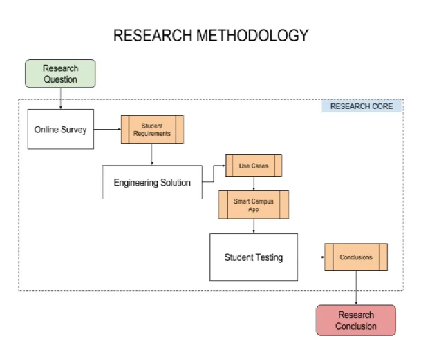
Fig. 4.1. – Research methodology implemented ... 23
Fig. 4.2. - Survey Question 9 ... 26
Fig. 4.3. - Survey Question 10 ... 27
Fig. 4.4. - Survey Question 16 ... 29
Fig. 4.5. - UJIntelligent - Application’s Use Case Diagram ... 33
Fig. 4.6. – The mobile application lifecycle MAL and its steps ... 39
Fig. 4.7. Front and Back end modules conforming the application core. ... 40
Fig. 4.8. - UJIntelligent application logo and slogan ... 43
Fig. 4.9. - Front-End Development components’ schema ... 44
Fig. 4.10. - Back-end development components’ schema ... 46
Fig. 4.11. – UJIntelligent source code repository ... 46
Fig. 4.12. - Testing strat8egy applied ... 48
Fig. 4.13. – Initial Interface ... 49
Fig. 4.14 – Navigation menu Interface ... 49
Fig. 4.16. – Selected Element on the map and detailed Information ... 50
Fig. 4.17. – Element detailed Info, saved ... 51
Fig. 4.18. – Routing service. ... 51
1. INTRODUCTION
1.1 THEORETICAL BACKGROUND
In the last decade, our society has witnessed how the information technologies are getting involved in our daily life activities. One of these activities is Education which uses many technological components, due to the way they evolve, converging towards a new concept named Education Informatisation. This concept is simply the combination of new technological advances in user mobility, networking, and computing systems in the development of a better learning experience for the students (Dong X., Kong X., Zhang F., Chen Z. and Kang J., 2016; Zhang Z., Chen W. and Liu Z., 2016).
Nowadays, universities must deal with the new trend of the current informatisation development well known as Smart Campus (SC) described as a new paradigm of ‘campus intelligence’, which is not only related to a set of facilities, infrastructures, services and people (Cambridge, 2016), but also regarding concepts in computing and technology such as e-learning, social networking, mobile applications and geospatial information. However, the most generic term for a SC is equivalent to the way in which universities evolve intelligently by offering targeted services to improve their community’s life. Universitat Jaume I - UJI is the educational centre located in the north of the Valencian Community, this region lies on the European Mediterranean coast between Valencia and Barcelona cities. Established in 1991, UJI has approximately 15,000 students enrolled, besides the fact that in this university there are 3 important languages that predominate inside the campus: Spanish, Valencian (for local students) (UJI, 2016).
Said university is therefore introduced as the study case for the implementation of a smart campus infrastructure, as the university holds both, users: such as teachers, students, staff, and services: such commercial administrative management services, sports activities, academic, and even entertainment services. The management of all the information that is handled at the university is one of the tasks where more work and effort is required, because
there is a large amount of multidisciplinary and heterogeneous data stored in different data sources (Benedito-Bordonau M., Gargallo D., Avariento J., Sanchis A., Gould M. and Huerta J., 2010). Therefore, all these activities require a lot of information that can be consulted and accessible in a way that is useful for the whole community.
With the purpose of satisfying the data accessibility irrespective of user destination, it is essential to bring into context the awareness about mobile devices and smartphones nowadays. In Accord with Tom Ahonen, consultant and TED speaker: “Mobile is the enabling centrepiece of digital convergence. Mobile is the glue for all other digital industries to use when approaching convergence, but mobile is also the digital gateway for the real world to join in this global metamorphosis of human behaviour.” And this thought is supported widely around the world by every aspect of our lives, since there are mobile applications for anything that can be imagined.
In addition to this, covering the study case area and the use of mobile devices, Spain consolidated its leadership in the most important countries of the European Union in penetration of smartphones, with 81% of smartphones on the total of mobile phones, which is ten points above the average, after growing five points. In the last year, penetration rate of these devices has gone from representing 63% to 81% of mobile phones in Spain and stands out the 68% growth of the sale of tablets in 2016 in the country. The study points in Spain show that there are 23 million active users of applications that make 3.8 million daily downloads of applications. In this way, it can be stated that Internet access is becoming "increasingly mobile" and indicates that mobile terminals continue to gain market share from the fixed device and services that are increasingly used in mobility. Specifically, in 2016 more than 21.4 million Spaniards have accessed the Internet in mobility, which represents 4 million more than in 2015 (Telefonica Foundation, 2016).
The purpose of this research is to assess the ways in which a geospatial platform tool can improve navigation of campus grounds, management of data and information related to the university’s academic activities and related data elements.
1. Implement the methodology proposed in this research, by using mobile technologies, geospatial services and navigation systems to solve the UJI community requirements.
2. Integrate mobile services and technologies into a scalable and modular GeoApp called UJIntelligent.
3. Evaluate the interactions between the university community and the adapted GeoApp called UJIntelligent.
4. Enable UJIntelligent’s features and capabilities to be applicable to other SmCs or even Smart Cities.
1.3 DISSERTATION ORGANISATION
The structure of this document consists of six chapters: Introduction, Current Smart Campus Approaches, Analysing the Smart Campus Community, Research Methodology, Conclusions and Further Work. There is also one appendix named Appendix A: Survey Result.
The Introduction makes a brief description of what is the research question, presenting the term Smart Campus and bringing to the reader the main purpose to begin an investigation about how geospatial technology can improve the daily life in a university campus.
Literature review brings together a brief theoretical background to this research project where a selection of the top ten smart campus around the world per a previous research made by (Modolabs 2015). This list tells the reader about the principal features and service offered by those mobile applications inside the campus. After this, concepts such Mobile GIS, Navigation systems for
mobile geospatial applications, indoor for mobile geospatial applications and REST APIs to build mobile geospatial apps.
Case of Study encompasses the state of art which is the current situation in the University Jaume I that represents the specific study case of this research. Here the reader can figure out what is happening with the community technological requirements alongside the improvement of the internal process they offer and consume.
Research Methodology describes the steps and tasks implemented to answer the research question of this investigation project. This chapter also depicts the problems and achievements of the implemented process.
Conclusions chapter describes the final asseverations of this work (including a discussion) and further work which exposes things that have not been developed due to time restrictions and that will be interesting to consider in future research projects.
2. LITERATURE REVIEW
2.1 RESEARCH CONTEXT
In previous years, a SC type project named "Smart UJI" (SmU) was proposed and implemented at the Jaume I University (Smart Campus, 2010). This project intended to encompass in a single application the access to information associated with university services from a single point, homogeneously and Easily accessible to users inside the campus (Benedito-Bordonau M., Gargallo D., Avariento J., Sanchis A., Gould M. and Huerta J., 2010).
SmU was designed with the aim of incorporating functionalities such: visualize over the university map the services offered by the various areas and dependencies in the campus using geographical location supported by alphanumerical data and information.
The objective of this project is to offer users the possibility of finding physical facilities inside UJI such as offices associated with teachers, laboratories, research groups, academic offices, auditoriums and sports areas. In addition to this, it had also been proposed to include a route system to arrive, from an origin point towards certain location destination (Benedito-Bordonau M., Gargallo D., Avariento J., Sanchis A., Gould M. and Huerta J., 2010).
The main drawback this project faced, was that on one hand there was a low investment of both human and financial resources. This situation led to delays in the process of project analysis and development. Another important aspect affecting this project was the implementation of the latest technology that helped to solve the main functionalities and user requirements since delays made this project year after year to become an obsolete platform-tool, with a non-friendly user interface and therefore lost in the time.
It is for this reason, that research groups at the university, such as GEOTEC1,
and including this master research thesis consider important to know if this kind of project is still feasible and necessary on the campus of the UJI.
2.2 CURRENT SMART CAMPUS APPROACHES
In this section, it has been analysed previous endeavours on other university projects concerned to a SC application on mobile devices, which has demonstrated the efficacy of applying such technologies. For the past year 2015, it is presented a summary in Table 1 of universities that accomplish the bar on the mobile campus experience, and take their SC apps beyond the basic requirements (Modolabs 2015). While including the practical functions and information that students rely on remains critical for mobile campus apps, some mentioned universities took advantage of advanced features and use-cases that took student engagement to the next level.
APP NAME
California State University, Northridge: CSUN
Mobile App.
DESCRIPTION
CSUN was created to make it easier for students to access campus services and resources on the go.
FUNCTIONALITIES
Weekly schedule, student academic calendar, grades, test scores, account summary, ask help, athletics, calendar, dining, emergency info, employee directory, employee etravel, enrolment, class search, enrol in class, registration planner, enrolment appointment, indoor maps, library, map (directory and gps-enabled map and search), Moodle, financial aid, news, personal information , photos, police, services, purchase parking, social media, src (student recreation centre), student directory, tour, transit (housing shuttle, metro, metrolink and traffic conditions), tutorial, video.
DOWNLOAD
Google Play: http://bit.ly/2hqS9LZ App Store: http://apple.co/2huJ6Lm Table 2.1 – California State University App
APP NAME Colgate Mobile, Colgate University
DESCRIPTION
The Colgate mobile application offers information for current students in the Campus edition, and an alumni directory plus numerous options for staying connected in the Alumni edition. Download one app, and choose your version at the bottom of the screen.
FUNCTIONALITIES
Cruiser, dining, calendar, Moodle, portal, directory, facility hours, athletics, map, emergency info, get involved, raider rewards, local area, university radio, libraries, webcam.
DOWNLOAD
Google Play: http://bit.ly/2hlNyrb App Store: http://apple.co/2ibX2Hz
Table 2.2 - Colgate University App
APP NAME VikingGO, Del Mar College District
DESCRIPTION
VikingGO is designed for anyone who wants on-the-go information or wants to stay connected to Del Mar College.
FUNCTIONALITIES
Cruiser, dining, calendar, Moodle, portal, directory, facility hours, athletics, map, emergency info, get involved, raider rewards, local area, university radio, libraries, webcam.
DOWNLOAD
Google Play: http://bit.ly/2hlNyrb App Store: http://apple.co/2ibX2Hz
Table 2.3 - VikingGO App
APP NAME Fitchburg State Mobile, Fitchburg State University
DESCRIPTION
Fitchburg State Mobile is the official mobile app from Fitchburg State University, providing on-the-go
access to a variety of campus information and services.
FUNCTIONALITIES
Admissions, tour, map, shuttles, directory, courses, athletics, dining, library, news, calendar, social media.
DOWNLOAD
Google Play: http://bit.ly/2if7SyL App Store: http://apple.co/2ioUkxR
Table 2.4 - Fitchburg State App
APP NAME Georgetown Mobile, Georgetown University
DESCRIPTION
Georgetown Mobile is a university-wide mobile initiative to aggregate and deliver useful, mobile-appropriate content to university communities, locally and worldwide.
FUNCTIONALITIES
Weekly events, university transport system, dining, map, directory, calendar, news, athletics, video, photos, libraries, emergency info.
DOWNLOAD
Google Play: http://bit.ly/2ioMF2A App Store: http://apple.co/2ic1ZzV
Table 2.5 - Georgetown University App
APP NAME
Maine Maritime Academy Mobile, Maine Maritime
Academy
DESCRIPTION
Official college app, developed to provide alumni, students, faculty, staff, and visitors all the MMA resources they need in one compact and easy-to-use tool.
FUNCTIONALITIES
Social, new, events, map, dining, webcam, MMA Weather, athletics, directory, admissions, campus safety.
DOWNLOAD
Google Play: http://bit.ly/2hr3Ulw App Store: http://apple.co/2huNzxS
Table 2.6 - MMA App
APP NAME Qatar University Mobile, Qatar University
DESCRIPTION
QU Mobile is the official app of Qatar University, which is part of an ongoing project that was initiated to enhance the experience of the organization’s members and visitors who interact with its various services and resources.
FUNCTIONALITIES
News, calendar, directory, maps, video, photos, social, banner, catalogue, blackboard, dining, library,
DOWNLOAD
Google Play: http://bit.ly/2ifbCAj
App Store: http://apple.co/2hlQgwC
Table 2.7 - Qatar University App
APP NAME
Living at UMass, University of Massachusetts
Amherst
DESCRIPTION
A mobile application that provides the University of Massachusetts Amherst community with mobile access to the Campus Pulse events calendar, Living at Umass.
FUNCTIONALITIES
Student life calendars, university event calendars, social media, photos, videos, move-in alerts.
DOWNLOAD
Google Play: http://bit.ly/2iBAra7 App Store: http://apple.co/2iByzhD
Table 2.8 - Umass App
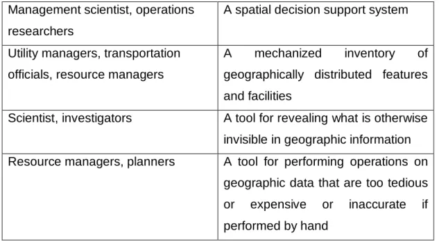
APP NAME
CarolinaGO, University of North Carolina at Chapel
Hill
DESCRIPTION
Carolina GO is a student-initiated project designed to improve the mobile space of all students, faculty, and staff at the University of North Carolina at Chapel Hill.
FUNCTIONALITIES
Directory, news, map, dining, videos, emergency, course, bus routes.
DOWNLOAD
Google Play: http://bit.ly/2iC67Z7 App Store: http://apple.co/2huP2Eo
Table 2.9 - CarolinaGO App
APP NAME ND Mobile, University of Notre Dame
DESCRIPTION
Get essential Notre Dame information & services anytime, anywhere on your mobile device. The ND Mobile App provides a variety of campus information and services on your mobile device.
FUNCTIONALITIES
Dining, athletics, map, academics, weather, directory, laundry, news, video, calendar, social, emergency, libraries, photos.
DOWNLOAD
Google Play: http://bit.ly/2ibWTnf App Store: http://apple.co/2i5khVI
From the study of each mobile application some asseverations were outlined as a common feature regarding the services provided by them. On the one hand, most of the apps function like an information provider, only to consult data to be prompted to users (in most of the cases for Students). The info that can be consulted is related to services and element inside the campus. Only few apps, for instance the California State University, Northridge mobile application offers various modules to interact and update information related to academic courses, besides the fact of being integrated with the virtual class platforms to submit material such class’ assignments and tasks. On the other hand, the topic related to geographic information was also analysed on these apps. All of them visualizes the university campus on a map, presenting data associated to the facilities, services, events and procedures within the main campuses. The main goal of presenting geographic information is to provide meaningful and comprehensive data that can be accessed in real time and that can help in a decision-making process. As stated for in the GI science digital representation of geography contains several advantages like fast to access, sharing on real time, easy to process and friendly visualisation. Nowadays almost all human activities and decisions involve a geographic component (Longley P., Goodchild M., Maguire D., Rhind D., 2011).
2.2 MOBILE GIS
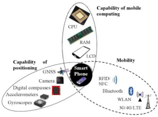
Certain definitions of GIS are described depending on the context and the role of the user who is implementing it. The next image summarized different concepts attributed.
USER ROLE DEFINITION
The general public A container of maps in digital form Decision makers, community groups,
planners
A computerised tool for solving geographic problems
Management scientist, operations researchers
A spatial decision support system
Utility managers, transportation officials, resource managers
A mechanized inventory of geographically distributed features and facilities
Scientist, investigators A tool for revealing what is otherwise invisible in geographic information Resource managers, planners A tool for performing operations on
geographic data that are too tedious or expensive or inaccurate if performed by hand
Table 2.11 – Definitions of a GIS, and the groups who find them useful (source: (Longley P., Goodchild M., Maguire D., Rhind D., 2011)).
The world-wide definition coming from ESRI states that GIS is a computer-based tool that analyses, stores, manipulates and visualizes geographic information on a map. GIS links geographic locations on earth with attribute information enabling users to visualize patterns, understand relationships and trends (ESRI 2017). Modelling, processing and displaying geographic data requires large computational task. In the past, traditionally the trend was to host such tasks in high performance servers or desktop PCs. Nevertheless, the constant and fast development of mobile technologies now has changed the role of mobile devices in geospatial computing.
There exist many reasons that mobile devices have become a meaningful platform, to start with as its name states, mobility enables both, small size and connectivity. Secondly the positioning capabilities (either outdoor or indoor), thirdly the rapidly computing improvements in mobile devices hardware, fourthly the wide range of users holding a mobile device around the world and finally the vast quantity of mobile application software developed (Chen R. and Guinness R. 2014).
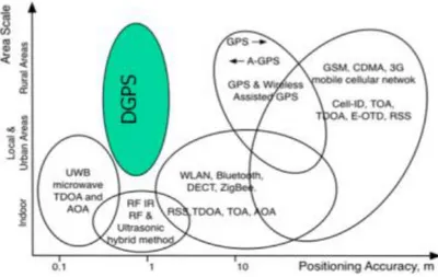
According to Ruizhi Chen the hardware components of a smart mobile device is separated into three groups: computational hardware components, peripheral
sensors for enabling capability of positioning and technologies that allow portability and ubiquitously.
Fig 2.1. – Hardware components in mobile devise, smartphone example (source: (Chen R. and Guinness R. 2014)).
For a better optimisation of these aspects mentioned in the last paragraph, Mobile GIS is, the expansion of GIS technology from the office to the field. A Mobile GIS permits field-based labourers to capture, store, update, manipulate and display geographic information. New developments in mobile GIS, like mobile applications or geospatial APIs (Data sources containing geospatial attributes) enables users and organizations to add and edit real-time information, speeding up analysis, display and decision making by using up-to-date, more accurate spatial data. (ESRI 2007).
2.3 CONTEXT FOR MOBILE APPLICATIONS
For Mobile Geospatial applications, the surrounding environment and specific geographical location should be considered as a mutable information source
with people who is using the application. Is in this case, that explicit focus must be settled on the dynamic interactions between individuals, mobile devices and environments (Li, C. 2006). Following to Haklay M., the main goal in a mobile geospatial application is to develop mobile context-aware functions. This idea consists on providing services to users that support their activities in mobile situations, context-awareness of users and their environment. Thus, understanding context is central to mobile geospatial applications (Mordechai Haklay 2010).
In accordance to (Bisgaard J., Heise M., Steffensen C. 2012) context is defined as the interrelated conditions in which something exists or occurs. This means that context is the mutual relationship between several conditions that exist in each situation in which an actor is situated or a specific event is happening. In this order two principal focuses applied to the definition of context, a user and a system centred focus.
For a user centred understanding of context applied to the field of mobile geospatial applications, defines (Schilit B., Adams N., Want R 1994) that the three relevant properties of context are the where you are, who you are with and what resources are adjacent. For a system centred focus, context is expressed such everything that affects the computation, excluding the input and output data. (Lieberman M. 2010). Is by these two definitions of context that it can be inferred as any kind of information implemented to classify the situation of an entity (object, place or user or application).
Last research on context awareness are related to location, mobility and time, the following table explain each concept in more detail for understanding. (Khan and Markopoulos 2007).
Location
Sometime is defined a position on the surface of the Earth without any unique connotation, a surrounding environment or a meaningful place.
Mobility
Reflects user in circumstances where they are constantly on movement at a certain place.
Time
This notion adds another dimension to
context, like a momentary instant or as a fixed floating period. Time can be absolute or relative.
Table 2.12 – Definitions of context awareness contexts (source: (Khan and Markopoulos 2007)).
In general, using mobile geospatial applications can benefit from awareness of context in two modes: initially, across adjustment of content to changes in the environment; then secondly, through enhancement of the interaction with users. Context information affords a means to filter the flow of information that comes from service providers towards the user, and thereby, to solve the problem of information overload contributing to a higher significance of the information requested by the user.
2.4 NAVIGATION SYSTEMS FOR MOBILE APPLICATIONS
In mobile contexts like pedestrian navigation, the user is frequently on-the-go and thus interacting in an endless group of environments. In a daily life situation, users might at one moment be located inside an institutional building and right at the next moment, they might find themselves ending up towards a parking spot or a green area in the city. The variability of the environment is also affected by the fact that users are not static elements stick to streets roads (Münzer S., Stahl C. 2008). Activities like taking shortcuts or taking underground paths can also place users in a dissimilar and potentially adverse context inside a short instance in time, hence necessitating that communication with the user through various modalities take into consideration the surrounding context.
So, for mobile geospatial applications there two contexts in terms of location that is often divided by outdoor and indoor location (Wasinger R. 2006).
Fig 2.2. – Environment contexts used with navigation system by pedestrian users (source: (Wasinger R. 2006)).
Mobile devices such smartphones or tablets are rich in communication technologies. Mainly, it has its GSM voice and data communications, in addition to Wi-Fi wireless, infrared, and Bluetooth communications. The position of mobile devices is essential requirement for mobile GIS, therefore current positional technologies are categorised into outdoor an indoor positioning. Only shortly mentioned, in the case of outdoor positioning techniques there exist: GPS, Assisted-GPS (AGPS), mobile GSM network.
2.4.1 INDOOR NAVIGATION
The GPS Positioning is the desired technology for location purpose in open areas, and with differential improvements it leads to higher accurateness. Nonetheless, GPS does not work inside facilities or in covered areas. Techniques such infra-red, ultra-sonic, radio signals or visible light are implemented to supply this location necessity. Among these methods, time of arrival where the travel time of a signal between a transmitter and a receiver is obtained, Cell of Origin where the location of user is described in a certain cell area around the transmitter. (Evennou F. and Marx Francois 2006). Time difference of arrival where the time difference of signals sent from a transmitter is determined at two receiving stations, signal strength measurement for location determination using Wi-Fi or WLAN fingerprint where the values are compared with prior collected values in a database and the location is acquired operating matching approach. (Mohamed Eleiche 2011).
Fig 2.3. - Comparison of different positioning technologies (source: (Mohamed Eleiche
2011)).
2.4.1 REST APIS TO BUILD MOBILE GIS APPS
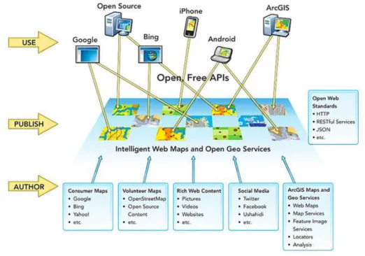
The Representational State Transfer (REST) style is an abstraction of the architectural elements within a distributed hypermedia system. Rest ignores the details of component implementation and protocol syntax for focusing on the roles of components; the constrains upon their interaction with another component, and their interpretation of significant data elements (Thomas R. 2000). While REST captures the fundamental principles that underlie the Web, the World Wide Web is made of millions of websites, running atop thousands of different server implementations, and undergoing periodic redesigns. Websites are accessed by billions of users who are using hundreds of different client implementations on dozens of hardware platforms. Nowadays we might talk more about the web as an application platform, recently in which the web emerges as a means of connecting distributed applications. This is the result of its simple architecture, the use of a widely implemented protocol HTPP, and the pervasiveness of common representation formats. The Web is no longer a large-scale information system, but a platform for an ecosystem of services (Webber J., Parastatidis S., Robinson I. 2010).
Nowadays, it is witnessed how web delivers both authors and consumer with a far-reaching platform for sharing and using a diversity of information, including geography and maps. Information systems have been migrating from a
client/server structure to a web-centric pattern for implementation. By their exposure to and use of rich information on the web and the use of new, elegant interfaces provided by mobile applications, organisations and enterprises desire a similar experience when they work with their operational information.
Fig 2.4. - Current platform distribution for Authors and Users on the web (source: (ESRI 2011)).
Numerous open web APIs follow then RESTful design patterns for distribution and contribution of map services, due to the maximisation of opportunities for adoption and use. This paradigm help software developers and application builders to combine different information sources in one (Richardson L., Amundsen M., Ruby S. 2012).
It is in this sense, that mobile geospatial applications implement the consumption of REST and RESTful services that eases information sharing, integration, besides the data scalability and security. This ensures that the choice of authoring platform is in no way constrained by the intended audience of the map service, because REST delivers open interchange of information amongst an extensive range of authoring tools and end-user applications. This pattern forces information delivery to the device using a common web pattern
3. CASE OF STUDY
University Jaume I has approximately 15,000 students enrolled in the main campus located in Castellón de la Plana, and more than 1000 employees with a current direct contract in the university.
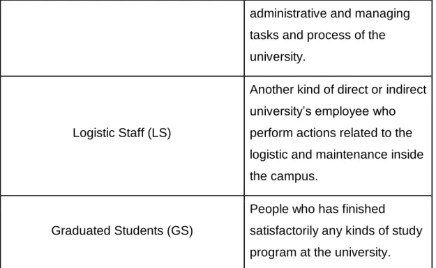
This research wants to focus the main necessities of the community in, and to achieve this, it requires firstly to classify the various types of users that continuously impact, affect and manage the normal management of the university. The next table shows the classification it has been considered more appropriate to categorize what are the most important and urgent requirements in the university.
Role Description
Former Students (FS)
Represented by all the alumnus of the campus, who are
attending a course, study program, pre-graduate or postgraduate program in the university. The students are categorized as new or ancient, from different parts of the world, different language and culture.
Professors (P)
This role is performed by the personal in charge of imparting the classes, lessons or courses in the university for the different kind of study programs.
Administrative Staff (AS) People who are identified as an employee in charge of the
administrative and managing tasks and process of the university.
Logistic Staff (LS)
Another kind of direct or indirect university’s employee who perform actions related to the logistic and maintenance inside the campus.
Graduated Students (GS)
People who has finished
satisfactorily any kinds of study program at the university. Table 3.1. - UJI community classification for user’s roles.
For carrying out this master research, it is indispensable to focus in the role which requires more demanding requirements inside the campus, in this case we have considered that the most demanding role of the university is the FS. In other words, the students represent the principal stakeholders or users to abstract the main requirements, for creating and improving the supported technological services at UJI.
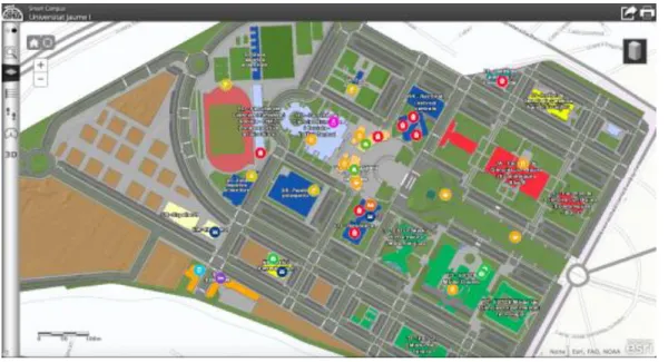
As it was stated in section 2.1 RESEARCH CONTEXT, last year the university created a SC project named "Smart UJI" (SmU), which basically was a web visor interface to access for location and data related to facilities, buildings an element in the campus. (Benedito-Bordonau M., Gargallo D., Avariento J., Sanchis A., Gould M. and Huerta J., 2010).
Fig 3.1. – First version of a Smart Campus Web Visor at UJI.
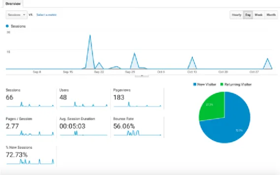
By the end of August of 2016, as part of the study case it was implemented google analytics (most popular search engine optimization SEO tool) with the objective to retrieve and compare the number of visitors that are not only inside but also outside the university campus that had access to the Smart UJI web visor. The results show that for the last 60 days after this study was launched, a total of 66 sessions requested the smart campus web visor, though from those sessions, in the end only 48 users visited it. With the data result showed in the next Figure 3.2, it is easy to conclude that for a University that counts with 15000 students, and in a period of the year when new users (students) are demanding for information about the campus which approximately is around 2000 new students per period (Study courses starts at UJI in the beginning of September), only 0.32% of the total students requested this smart campus platform and only 2.1% of the new students.
Fig 3.2. – Google Analytics result for the data related to visitor to the previous Smart Campus web visor.
Finally, the research question is more relevant if we consider the study case criteria for applying the proposed methodology, taking into mind the delimited approach to offer a conclusion for the suggested research question.
4. RESEARCH METHODOLOGY
The method applied in this research include the analysis of the university (UJI) community requirements by means of an online survey. After this survey, we propose as a technological solution the implementation of a mobile application, therefore it is explained in its design, development and test from two single user’s use cases. Finally, the solution is tested by the users to study the impact in different aspects of the university life. The method aims to answer the research questions related to the challenges that UJI as our study case is currently facing, to provide intelligent services supported by geographic information.
4.1 ONLINE SURVEY
A smart campus represents the integration of university services and process that integrated with technology and information systems can offer a high-quality life experience for the community inside the university campus.
With a technological perspective, we need to study and understand what are the main advantages and disadvantages presented in those services provided by the university the principal users to adopted in our study case, which is the FS.
Afterwards, it is essential to categorize specifically the principal disadvantages or weakness in the technological services as opportunities of improvement by listing them as user requirements. There are different techniques that can be implemented for extracting the user requirements in a business context, corresponding to the IIBA these are brainstorming, document analysis, focus groups, interface analysis, interviews, observation, prototyping, requirements workshops and survey/questionnaire (IIBA 2015).
In our case, at UJI, we decided to apply a survey since it has been used among previous software developments inside the research group INIT at UJI and widely recommended for business analyst professors.
This survey aimed to reach three principal topics involving the student’s life inside the campus. Firstly, we inquired about the usage of technology in the normal student academic life, for example the use of computers and mobile devices to satisfy the principal need of the students at the university. Secondly, it is important to recognize that in a more technical detail the description and characteristics of the kind of software and hardware used by the students, since for this research project it is desirable to know what are the tendencies when developing a technical solution as a smart campus. Finally, the survey focuses on the way the university nowadays provides services by using technological tools and services successfully. In addition, we also wanted to query the students about what they would consider to be a useful feature that a smart campus platform-tool can provide, and try to propose it as a future improvement
The survey has been designed to analyse how the use of technologies are required to perform various academic, sport or infrastructural services that UJI offers to its student community.2
4.1.1 SURVEY SIGNIFICANT RESULTS
After one month of work, the survey was submitted by 100 students from different study programs, ages and nationalities. The main idea was to set up a well distributed survey sample that can accurately represent the entire population of the university community. In other words, the survey focused on querying students in distributed locations inside the campus.
The results of the survey can be read in the Annex 1: Survey, however for this master research we focused on the main topics concern to what it can be understood as the student’s requirements to give an answer to our research question about the implementation of a smart campus platform tools inside UJI. As mentioned in the last section we want to analyse this survey by implementing two principal key topics: 1. Usage of mobile devices inside the campus and 2. Studying the actual technological services provided by UJI.
4.1.2 USAGE OF MOBILE DEVICES INSIDE THE CAMPUS
This topic allowed us to quantify what kind of technologies are the most used inside the campus, besides what kind of tendencies are currently being implemented of query for information concern to academic, administrative, sport or entertainment events at UJI. In this way, as stated by the Survey Annex 1. SECTION 2: DEVICE USE INSIDE THE CAMPUS, point 7. It can be concluded that the most used electronic devices are smartphones, laptop computers and tablets (with a smaller number of students) in the university. It is interesting to denote how at this moment, smartphones are the principal medium to participate actively in the university process and activities, due to
this conclusion, this research approaches the use of mobile devices by the community at UJI. Device % of Students Smartphone 88.1% Laptop 85.1% Tablet 29.7% Desktop Computer 25.7% Wearable Device 7.9%
Table 4.1. - Survey Question 7 snapshot.
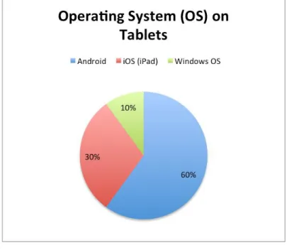
Therefore, it is a main point to solve questions related to the use of mobile devices such tablets and smartphones, so on the point 9. what kind of operating system (OS) does your tablet have? On the one hand 60% of student that uses tablets work on Android OS, 30% of them uses iOS for apple devices.
On the other hand, in question 10. Of the survey, 66% of students prefer to manage an Android OS smartphone, meanwhile only 30% of the students’ respondent would rather have an iOS smartphone.
Fig. 4.3. - Survey Question 10
In addition to this, it was also noticed a curious behaviour inside the campus, because although the most used tool required by UJI to perform certain academic activities is the computer laptop with 56.4% of the students (Annexe 1 - Question 12), most of them also think that this is the moment in which mobility is so determinant in the solution of issues, therefore smartphones are being perceived as the tool that can provide an enhancement to mobility for an on-the-field solution. Device % of Students Laptop 56.4% Desktop Computer 27.7% None of them 20.8% Smartphone 14.9%
Tablet 5%
Table 4.2. - Survey Question 13 snapshot.
Henceforth, that is why smartphones have been chosen as the main device to provide a solution to our research question. Smartphones are defined as a mobile device that allows users to manage several services that a computer offers (like receiving/sending emails, managing contacts and calendars, browse internet, playing games and having access to multimedia files) plus the use of the features that a single mobile phone offers (e.g. receiving/sending phone calls and text messages) (Ilyas M. and Ahson S. 2010), so now the university can combine the powerful and useful services provided by smartphones with their own academic and university services in order to satisfy the principal student’s requirements. The second section helped us to define what is the current mainstream technological tool inside UJI by the students, but now it is also essential to comprehend what services have been offered by the university either in their previous version of smart campus, or in their web page platform, or simply those services that are not using latest mobile technology as of yet.
4.1.3 STUDYING THE TECHNOLOGICAL SERVICES PROVIDED.
This key topic is referred to the final part of SECTION 3. University Technologies and Services and SECTION 4. University Technology Service Qualification, in the online survey evaluates the services and technologies provided by the university to solve principal issues in the student’s daily life. To begin, the survey focuses on what is the most common service used by the students in each device, however for our study case we want to analyse the use of software provided or not by the university by using smartphones. Question 16. What kind of activities do you normally do in your smartphone? This can give an answer of what is the main and even urgent requirement that UJI students are experiencing on a daily basis. Surprisingly, as it is shown in the next Figure 4.4.
Fig. 4.4. - Survey Question 16
The students expressed that Navigation inside the campus is the service more required and what they always implement is to find objects, people, facilities and events. 72% of the students consider navigation inside the campus as the most common service, therefore this research formulated a new question about what kind of software as web service or mobile application the community has implemented to offset this necessity in the last years. Generally, to find major facilities inside the campus students tend to use mobile mapping applications like google maps, and for specific information about offices, teachers or books they have access to the university portal, however without any location-based tool or software as a graphic support to identify the position of the wanted object. After this deduction, it is possible to integrate the lack of navigation systems on smartphones as a service offer by UJI.
4.1.4 SURVEY CONCLUSION.
To conclude with the analysis of the online survey, the purpose of this research is to generate a mobile geospatial application (app) functioning on Android Smartphones, due to the predominant use of this type of mobile operating system in the university. The principal concern of the students is to query and find the elements that exist and happen inside the campus, therefore it is
imperative to generate a better way to find elements inside the campus. For this research project, the elements queried in the university were: Professors, Facilities and Books, due to this information is already stored and manage in the research group GEOTEC’s servers and supported by a RESTful API, besides the geographic attribute for each facility.
4.2 STUDENTS’ REQUIREMENTS
Following the methodology, the next section shows the list of user’s requirements obtained by means of the online survey, they are sorted by priority and divided into two group, functional requirements (which represent the behaviour of the product and its features) and non-functional (those that describe environmental conditions for product) (PMI 2003).
4.2.1 FUNCTIONAL REQUIREMENTS
Requirement ID
FR-001
Description Develop a mobile application called “UJIntelligent” on Android OS for smartphones and tablets.
Dependency Smartphone
Actors Student
Preconditions An Android mobile device, sdk min version 17. Post
conditions
Provide the services offer by the smart campus application
Requirement ID
FR-002
Description “UJIntelligent” may offer services of navigation and geolocation for the user inside the campus.
Dependency Device’s GPS peripheral and internet connection. Actors Student
Preconditions An Android mobile device that supports gps navigation an
internet connection
Post
conditions
The users set on GPS location, then the users can find out their location inside the campus
Table 4.4. - User Requirement FR-002.
Requirement ID
FR-003
Description “UJIntelligent” displays specific data related to the geolocated Professors, Facilities and books inside the university campus, by means of a universal search option.
Dependency Device’s GPS peripheral and internet connection and
device storage
Actors Student
Preconditions An Android mobile device that supports a storage device
available of 50 MB.
Post
conditions
Users type a keyword in a universal search bar to look for a specific facility, book, office, building or teacher’s name, this
will appear in the screen displaying the attribute data related.
Table 4.5. - User Requirement FR-003.
Requirement ID
FR-004
Description “UJIntelligent” allows the user to navigate through the building levels or floors using indoor navigation
Dependency Device’s GPS peripheral and internet connection. Actors Student
Preconditions An Android mobile device that supports gps navigation an
internet connection
Post
conditions
The users set on GPS location, the user navigates indoor inside a building through the floors or levels.
Table 4.6. - User Requirement FR-004.
4.2.2 NON-FUNCTIONAL REQUIREMENTS
NFR-001 Develop the mobile solution by using an Android Development IDE
NFR-002 The mobile app may work on Android SDK platforms from 17 to 23
NFR-003 The web services must be supported and managed by swagger technology.
NFT-005 For control versioning, the applications’ source code will
be integrated to GIT project.
Table 4.7. - User’s Non-Functional Requirements.
4.3 ENGINEERING SOLUTION
The second step in the applied methodology for this research consists on extracting a general use case diagram in which all the user requirements interact to others and can be translated from a human language to a programming language after the engineering process. Eventually, the UML case diagram will be part of the input to develop the mobile application UJIntelligent alongside the functional and non-functional user requirements. When building the geoapp there are a described series of methodologies, strategies and even technologies that are very popular nowadays in big companies and technology factories around the world. This description represents the core of this thesis research, since by means of a mobile geospatial application, the new mobile technologies applied can be tested over the university community’s issues and the way they serve for refining the daily life in the campus.
4.3.1 USE CASE
Name UC1 - Navigate Inside the University Campus Brief
Descripti on
The Application provides services of navigation and routing for users inside the university campus to reach queried elements of it.
Actors Student Precondit
ions
- UC2. Geolocation by GPS - User position inside the campus
Basic Flow
1 - The student turn on the application
2 - The student push the GPS Location button
3 - The application geolocates the student by suing location and network services.
4 - The student can look for a specific element inside the university 5 - The student can follow the routing to the specific element in search
Alternate Flow
(No Network Connection)
1 - The student turn on the application
2 - The student push the GPS Location button
3 - The application geolocates the student by suing location in offline mode
4 - The student can look for a specific element inside the university 5 - The student can follow the routing to the specific element in search
Exception Flow
(No GPS enabled)
1 - The student turn on the application
2 - The student push the GPS Location button 3 - The App notifies the lack of Geoposition services
disabled.
Post Condition
The search service and the routing service are enable for the student
Table 4.8. - Use case UC1.
Name UC1.1 - Navigate Indoor Brief
Descriptio n
The Application provides Indoor navigation services inside the university campus’ facilities and buildings to reach and element of it.
Actors Student Preconditi
ons
- Network services ON.
- User position inside the campus - User location inside a building
Basic Flow 1 - The student turn on the application
2 - The application geolocates the student inside a building by suing location and network services.
Alternate Flow
No alternate scenario.
Exception Flow
(No Network Connection)
1 - The student turn on the application
2 - The student push the GPS Location button
3 - The application notifies the lack of network, which disables indoor location.
Post Condition
The search service and the routing service are enable for the student
Name UC1.2 - Navigate Outdoor Brief
Descriptio n
The Application provides Outdoor navigation services to reach and elements inside the campus.
Actors Student Preconditi
ons
- GPS turned ON - Network services ON.
- User position inside the campus
Basic Flow 1 - The student turn on the application
2 - The student push the GPS Location button 3 - The application geolocates the student.
Alternate Flow
(No Network Connection)
1 - The student turn on the application
2 - The student push the GPS Location button
3 - The application notifies the lack of network, which limits the accuracy of location.
Exception Flow
(No GPS enabled)
1 - The student turn on the application
2 - The student push the GPS Location button
3 - The App notifies the lack of Geolocation services.
Post Condition
The search service and the routing service are enable for the student
Table 4.10. - Use case UC1.2.
Name UC2 - Geolocation by GPS
n
Actors Student Preconditi
ons
- GPS service enable for the application - User position inside the campus
Basic Flow 1 - The student turn on the application
2 - The student push the GPS Location button
3 - The application geolocates the student by suing location and network services.
Alternate Flow
(No Network Connection)
1 - The student turn on the application
2 - The student push the GPS Location button
3 - The application geolocates the student by suing location in offline mode
Exception Flow
(No GPS enabled)
1 - The student turn on the application
2 - The student push the GPS Location button 3 - The App notifies the lack of Geoposition services
Post Condition
UC1.
Table 4.11. - Use case UC2.
Name UC3 - Query Data about elements inside the campus. Brief
Description
The Application offers the users the “find an object in the campus” service, by means of a keyword using autocomplete search, from different data resources integrated in a RESTful API
Preconditio ns
- UC2
- Network Services inside the campus - Network services in the mobile device
Basic Flow 1 - The student turn on the application
2 - UC2.
3 - The application determines the position of the element to find inside the campus
Alternate Flow
(No GPS enabled)
1 - The student turn on the application 2 - UC2
3 - The App notifies the lack of Geoposition services
4 - The application shows the element to find, but the routing service is not enabled.
Exception Flow
(No Network Connection)
1 - The student turn on the application
2 - The student push the GPS Location button
3 - The application geolocates the student by suing location in offline mode
4 - The service is interrupted for network connection lacking.
Post Condition
UC1: UC1.1 || UC1.2
Table 4.12. - Use case UC3.
Basically, there is a global module, the principal actor that handles the mobile solution is the student who in turn are also a catalogue as a global university user (inherited), performing the principal use case abstracted from the requirements, coded UC1: Navigate Inside the University Campus. This use case can be extended into two derived Use cases with different performance, yet offering the same service in different conditions: UC1.1: Navigate Indoor which enables the students to have an accurate location inside facilities and
location service offered by mobile devices nowadays plus the services of routing and search that UJIntelligent provides.
In addition to this, for navigation outdoor, it is important to implement the UC2 Geolocation by GPS. Finally, in the UC3. Query Data about elements inside the campus. The students can look for any element inside the campus as mentioned on the FR-003, and this mean that by using a simple search bar, the application will request the services provided by a RESTful API platform that integrates data sources containing the information about professors, book and facilities.
4.4 SMART CAMPUS APP
In this part of the proposed methodology, the implemented mobile application lifecycle (MAL) mostly well-known for decoupling the entire development process into different steps, to guarantee the quality over the construction process (Rossberg J., 2014). The MAL concept may vary from different authors, and therefore it was decided to apply some steps that we consider relevant and that in the following paragraph are going to be described into detail.
4.4.1 CONCEPT (SEPARATION OF CONCERNS)
After defining the use case for this application, in consonance with the applied methodology, the next outcome in the Engineering Solution step is to generate the mobile application itself. Before making this possible, it is important to consider the user requirements, specifically the non-functional requirements, which are those that describe environmental conditions for a product
When a software component as a mobile application separating along modalities permits to divide the application itself into different lines of expertise this perspective is commonly known as Separation of Concerns in software engineering (A.J. Sammes 2014). For most of the mobile applications in the market, these concerns are separated in two, the front-end and the back-end. To accomplish this stage in designing, it is necessary to define the components and modules that integrated define the app front-end. In parallel to the information prompted to users must be processed previously by some origin data by using a data access layer, to integrate the modules, interfaces and data sources defining the application back-end.
In the next Image the mobile application integrates for both a front-end module well-known as View and an Interface with the aim to retrieve the data hosted remotely.
4.4.1.1 APPLICATION FRONT-END
In this paragraph, it is described the various parts that composes the mobile application front-end. Essentially the front-end can be considered like the Views and Controller components covering more than the 80% of the entire application. These components were chosen and designed by using the functional and non-functional user requirements. For an Android, mobile application and its user interface it was implemented where Android SDK, that performs interfaces integrating light and material design concepts (this concepts will be explained into detail in the next process level 2. Prototyping). In Addition, this mobile application displays geographic data using maps, therefore for this aim the interface implements the ArcGIS SDK runtime for android technology powering the app with different visual maps with detailed graphical information about the land and its uses. This SDK (software development kit) eases the connection and request of not only geospatial information but also services and process that hosted over the ArcGIS server belonging to the research group GEOTEC and INIT at UJI, gives a more understandable and meaningful geographical information.
4.4.1.2 APPLICATION BACK-END
The mobile back-end are all the pieces that enables an interface connection to all the data sources located either locally or remotely and that also are considered as the data input to be processed and prompted on the application view. For the UJIntelligent application, part of the front end is the interface connection to the services situated in a remote API server that gather the data concerning the university facilities books and professors. As it was briefly explained in the front-end section, the geographic information is enhanced and delivered by the ArcGIS server hosted at GEOTEC group. This server provides web map services, feature services, map layers and even services of routing and geolocation.
like to find a book inside the campus which is in the library, the empty information about the buildings is not enough meaningful regarding positioning and orientation. Thus, the mobile application must support indoor detail maps about the levels, rooms, offices, bookcases, emergency ways, and so to support the indoor navigation service. As a strategy to maintain battery levels stable and to decrease the data consumption in the average, this app provides indoor maps by using a local geodatabase stored in the mobile application memory card. Finally, to make available for getting this information the back-end module must be integrated with a geodatabase interface by using SQL language to query it.
4.4.2 PROTOTYPING
Finishing the separation of concerns, and having as a source of work the front-end definition, as the same name says, prototyping is the part of the process that generates the visual schemas, drafts or mock-ups before coding the application. The purpose in this step is entirely visual, due to the designing of user interfaces and interactions according to the user requirements defined on the previous concept step. For this project, it was decided to implement the modelling tool named JustInMind, that introduces the concepts of wireframes and smart prototyping considering the hierarchy and flow of the user interfaces. Also, when designing the user interfaces some relevant guidelines on Material Design (MD)3 were applied with the aim of provide the best user-experience
and visually efficient to users (Google Inc., 2016).
One of the outcome of prototyping are the mockups and wireframes that summarize the application’s behaviour and flow, as the graphic interface containing components such as the map, buttons, menus, toolbars, etc. along with their features.
To start with, the mobile application icon and slogan were previously defined by the research group GEOTEC. This logo is based on the institutional and