K
BULLETIN OF THE SERBIAN GEOGRAPHICAL SOCIETY
2010.
XC -
. 3
YEAR 2010 TOME XC - N 3
O UDC 912
DOI: 10.2298/GSGD1003207B
А А А Ј
Ј А А
*1
, Ћ1
, Ћ2
1 ј ,М ј К 5 , , С ј
2 У – , С 3/3, , С ј
:
.
1:25.000, 1.250.000, 1:300.000 1:1.000.000.
, . ,
ђ .
: , , .
( ) ,
1876. . , ,
. ђ : 1:
25.000, 1:50.000, 1:100.000 1:200.000 1:250.000,
1:300.000 and 1:500.000, 1:1.000.000 1:1.500.000
.
, , , ,
. .
20. ,
. -
-
ђ . ( . , 2009)
, ,
,
,
( ).
ђ
. ђ
, . ( ., 2006)
,
-ђ .
( ., 2006)
ђ
, , ђ
. ,
ђ . ( ., 2006)
'' –
.'' (Maynew S., 1997)
.
1: 1.000.000 ( 1000)
1: 1.000.000
, ђ 2005. . ђ
ђ 1: 1.000.000, :
NL-34 Beograd NK-34 Skopje. ,
.
-
.
8 :
¾ ,
¾ ,
¾ , ¾ , ¾ , ¾ , ¾ ¾ . 1000
. 2010. .
1: 300.000 ( 300)
1:300.000
1997. , 1998. ђ
1:300.000.
1: 300.000 1: 200.000
, 300
ђ
(ArcGIS, Maplnfo, .). , (
, ,
, .).
300 14 , 13 ( 1).
1. 300 .
1: 300.000,
. , 75%
, . ,
50%. 300 .
ђ 2010. .
13
( ):
¾ (4 );
¾ (3 );
¾ (14 );
¾ (18 );
¾ (4 );
¾ (3 );
¾ (2 );
¾ - (7 );
¾ (3 );
¾ (5 );
¾ (1 );
¾ (1 ).
2. 1: 300.000
1: 25.000 ( 25)
1: 25.000 ( 25)
.
732 25 ( 7′30″x7′30″). ,
2002.
. ђ 25
. 2004. ,
25, ,
, .
. ,
/ GPS ,
3 ( ).
, 2004. , ђ 300
( 45% 1: 25.000)
( 4). ,
, ,
( - , ,
) NATO (UTM, WGS84, MGRS). ( .,
5. 25
1: 250.000 ( 250)
( ђ NATO – Joint Operations Graphic) (JOG-G)
.
2006. . ђ
ђ
NATO ,
NATO .
6. 250
:
, 250 ,
.
300 1:
200.000 ,
, ,
.
1: 250.000 7. (
7. 250
NATO :
( G JOG-G "ground" . )
( JOG-
" ir"- , "aeronautical" . , ).
, ,
( 8).
-, , .
( , , .), ђ
.
-, :
• 1:1.500.000 ( ),
• 1:1.500.000 ( ),
• 1:500 000 ( ),
• 1:300 000 (13 ),
• 1:500.000 ( , 9),
• 1:500.000 ( ),
• 1:200.000 (22 ),
• 1:50.000 ( 10).
9. 1: 500.000
. -, , . . , , ,
, . ( ., 2005)
. :
• ,
;
• ђ ,
, ; • ђ ( ); • ( , ) ; • ;
• , ђ
, . ( . .,
2001)
.
:
• ђ ( ,
. );
• ;
• ;
• '' '';
• x y ;
• ;
• ђ ;
• ;
• . ( ., 2008)
ђ
, ,
,
.
,
, . ,
ђ
ISO
.
: ''
, .
.
.
( )
, . ,
. ( ).
'' '' .'' (Guay
L.A., 1990)
Arlinghaus, S.L. (2001). Practical Handbook of Digital Mapping – Terms and Concepts. CRC Press Inc., Boca Raton, Florida, USA
Borisov, M. (2005). Topografsko – kartografski sistem prema novim vojnim standardima, Vojnotehnički glasnik3-4,
315-325.
, ., , . , . (2009). ,
С , 89(3), 207-218.
, . (2009). , , 38, 13-19.
, . (2008). ј 1: 50.000
. : , .
Guay L.A. (1990). Multimedia Atlas. National Atlas Information Services Opportunities Seminar, Ottawa, Canada. . (2006). : . С , 86(2), 237-250 , . (2008). - . С ,88(3),
11-24
, . . . (2001): К ј . ,
Maynew S. (1997). Dictionary of Geography. New Edition, Oxford University Press, New York, US
, . (2008). ј 1:50000
. , ,
, . (2009). STANAG2215 – NATO . "3.
DOI: 10.2298/GSGD1003207B
THE NEW CARTOGRAPHIC PROJECTS IN THE MILITARY GEOGRAPHICAL INSTITUT
MIRKO BORISOV*1,STEVAN RADOJČIĆ1,VESNA IKONOVIĆ2
1Military Geographical Institute,Mije Kovačevića 5, Belgrade, Serbia 2 University of Belgrade - Faculty of Geography, Studentski trg 3/3, Belgrade, Serbia
Abstract: This paper gives an overview and some details about a few new projects in area of digital cartography
production of Military Geographical Institute. The maps are presented at scales 1:25.000, 1.250.000, 1:300.000 and 1:1.000.000. All of them are made in order to satisfy rigorous criterion of Serbian Armed Forces, as a main user of those maps. Those are the first digital topographic, overview topographic and geographic maps in Serbia, too.
Key words: Cartography, Military Geographical Institute, Digital maps.
Introduction
The Military Geographical Institute (MGI) is the leading cartographic institution in Serbia, founded in 1876. The MGI is in charge for production of topographic, thematic, plastic relief and other maps and cartographic products of national territory, in order to satisfy Serbian military needs. It produces a very wide assortment of maps: topographic maps at scales 1: 25.000, 1:50.000, 1:100.000 1:200.000 and 1: 250.000, overview topographic maps at scales 1:300.000 and 1:500.000, geographic maps 1:1.000.000 and
1:1.500.000, and a number of small scale thematic maps and plastic relief maps. The most
of those maps are used by the state authorities and other subjects in Serbia as national maps, for planning, studing, education, scientific projects, etc. The MGI is a national cartographic institution.
From the early nineties of 20th century, the MGI's production have focused on
creation digital map and geographical information systems. The first activity in the world of digital cartography - next to educational activities in order to make a proper cadre and to get the necessary hardware and software - was scanning and georeferencing all paper maps. A few years later, the main attention is payed on transform existing and to create a new digital vector maps, with database and digital terrain model. (Borisov, M and group of authors, 2009) It stage still lasts and it is the future of MGI's cartographic activity. In Military-geographical institute the most cartographical models are making in the form of maps.
The cartographic modelling, as subjective reflection of reality, is in harmony with a general theory of knowladge where is diferention beetwen view from imagination, which in ontological sence has concequence diferences among passive and ontological, as well as particular and general aspect reality objects as subjects of researching (cartographing ). In process of cartographing modelling (by cartographing method) a particular spatial system or its element replaces by suitable cartographic model. This process understands special
researching procedures of watching, analysing and experimenting at model. (Ikonović V,
2006)
Map is conditionally mathematical reduced, generalised and construced image-sign model of an particural space in analogical or digital form. Ikonović V, 2006)
Digital map is such form of representation of particular territory where are objects,
lines and areas change in data, which are, by softwares and mashines for printing, turne in analogical form. Ikonović V, 2006)
Electronic map is map on electronic medium – personal computer or working station. (Maynew S. 1997)
Electronic map is representation of spatial data on the computer screan.
The Digital Geographic Map at scale 1:1.000.000 (DGM1000)
The Digital Geographic Map at scale 1:1.000.000 is the first digital vector map made in Serbia (1995). Originally, it was done as a part of the project of making sheets of The International Map of the World, which cover Serbian territory, NL-34 Belgrade and NK-34 Skopje. Later, the two sheets were incoporated in order to get whole Serbian territory in single sheet.
The main cartographic sources were the editorial originals which were scanned from plastic foils and transform into the defined projection plane using affine transformation. It was made in Lambert Conformal Conic projection with two standard parallels.
The database comprises 8 classes of data:
¾ Hidrography,
¾ Contour and depth lines,
¾ Peak elevation,
¾ Settlements,
¾ Railroads,
¾ Roads,
¾ Borders,
¾ Objects.
The DGM1000 is regularly updated. The newest version is made in 2010.
The Digital Overview Topographic Map at scale 1:300.000 (DOTM300)
The updating of conventional cartographic produced maps at this scale are stopped by the end of year 1997. A new project called “Digital Overview Topographic Map'' at scale 1:300.000” (DOTM300) was started in 1998.
On the basis of hard copy and rasterized topographical maps at the scale 1:300 000 and 1:200 000 as the main sources, there was created a digital map of Serbia with databases and digital terrain model (in 100mx100m rezolution), in format that provides its use and exchange in the familiar GIS-software applications (Arc GIS, Maplnfo etc.). Of course, the other sources were widely used, such as different statistical sources, the rasterized topographic maps at larger scales, remotely sensed images, contour lines in digital format, etc. The DOTM has 14 sheets, 13 of them covering Serbian territory (Figure 1).
The main objective of this project was to design a GIS aplication at resolution 1:300.000 and the same scale digital topographic map, with hard-copy output capability. By the end of 2004, DOTM300 has been realized. According to statistics, 75 % of cartographic processes are carried out automatically and the rest are made interactively. On the other hand, time spent for production decreased to 50 %.
The DOTM300 is regularly updated. The newest version is made in 2010.
Fig. 1. The sheets of DOTM300
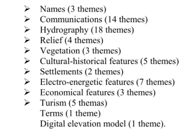
Content of data in vector format is grouped into 13 layers:
¾ Names (3 themes)
¾ Communications (14 themes)
¾ Hydrography (18 themes)
¾ Relief (4 themes)
¾ Vegetation (3 themes)
¾ Cultural-historical features (5 themes)
¾ Settlements (2 themes)
¾ Electro-energetic features (7 themes)
¾ Economical features (3 themes)
¾ Turism (5 themas)
¾ Terms (1 theme)
¾ Digital elevation model (1 theme).
Fig. 2. Digital overview topographic map 1:300.000
The Digital Topographic Map at scale 1:25.000 (DTM25)
The Topographic Map at scale 1:25.000 (TM25) is the basic MGI's topographic map and all other topographic maps made by MGI are derived from it. It has 732 sheets (with 7′30″x7′30″ dimension) covering the Serbian territory. In 2002, the MGI is started project "Digital Elevation Model" in 1:25.000 rezolution. It was the begining of transforming TM25 from classical cartographic form to digital form. From the end od 2004, all hard copy layers of TM25 were scanned and vectorized. Parallel with that work, the projected database was created, i.e. the Logical Data Model and Digital Cartographic Symbology were developed and adopted. After that, the each vectorized sheet was updated by photogrametry and/or GPS survey and exposed to through the procedure shown in Figure 3 (right branch).
Fig. 3. General technological scheme of DTM25
In that way, from the end of 2004 till today, more than 300 sheets (45% of total), are produced and updated digitally, creating the 1:25.000 Digital Topographic Map (Figure 4. At the end of the production, two products are obtained, one is vector and the other is a raster product. In both cases, maps are delivered in desired mathematical frame, usually according the national standards (Gauss-Krueger projection, Bessel's ellipsoid, national grid
reference system) or NATO standars (UTM, WGS84, MGRS). (Radojčić S., 2009)
Fig. 4. The current status of DTM25
Fig. 5: Digital topographic map 1:25.000 (printed sheet)
The Digital Topographic Map at scale 1:250.000 (DTM250)
made according to the NATO standards – Joint Operations Graphic (JOG-G)
This is the newest MGI digital map. The preparation works started on July 2006. and lasted more than one year. This map was created in order to provide compatibility of the scale series of our topographic maps with the scale series of topographic maps of NATO and EU, and to test MGI's capabillity to made a map according to the NATO standards (STANAGs). It has 18 sheets, and 14 of them covering Serbian territory (Figure 6). (Radojčić S., 2009)
Fig. 6.Overview of sheets for DTM250
The technological process itself included the following activities: collecting of the available data sources, production of TM250 in digital form and in GIS environment, preparation digital version for printing, and printing itself. Basic data sources were geo-database of DOTM300 and the digital raster format of the topographic map at scale 1:200.000, while subsidiary sources were diferent statistical sources, the rasterized topographic maps at larger scales, remotely sensed images and contour lines in digital
format. DTM250 production work-flow is given in Figure 7. (Tatomirović S. And group of
authors, 2009)
It is important to remark that NATO standards prescribe two version of map in this scale: land map (JOG-G which means "ground") and aeronautical chart (JOG-A which means "air" or "aeronautical"). In this stage, MGI is done only ground version (by the end of 2010), and aeronautical version will be done in future (Figure 8).
Fig. 8. Marginal data of DTM250
Thematic map production
One of the most important task of MGI is to produce varios kinds of tematic maps, for military as well as for civilian purposes. Some of them are in analogical form (plastic relief maps, road maps, etc.), but most of them are in both, the digital and the analogical form. Examples of the thematic maps produced in last five years are:
•1:1.500.000 scale Physical Map of Serbia (single sheet),
•1:1.500.000 scale Plastic Relief Map of Serbia (single sheet),
•1:500 000 scale Plastic Relief Map of Serbia (two sheets),
•1:300 000 scale Plastic Relief Map of Serbia (13 sheets),
•1:500.000 scale Road Map of Serbia (two sheets, Figure 9),
•1:500.000 scale Military Aeronautical Map of Serbia (4 sheets),
•1:200.000 scale Military Aeronautical Map of Serbia (22 sheets),
•1:50.000 Thematic Map of Water Facilities of Serbia (Figure 10).
Fig. 9: Road Map of Serbia 1: 500.000
Fig. 10: Water Facilities Map of Serbia 1: 50.000
Applications of cartographic vizualization methods in making digital maps
Vizualization is the field of computer graphic which exploring analitical and comucational possibilities of vizual presentations. Vizualization researces posibilities of images, like 3D world, to use as models. Vizualization demands usage the latest and the best computer tehnology. It depend from new computer techniks of analysis, processing, manipulations and presentations of data, as well as their egsactnes and form of representations. (Ikonović V., 2005)
To be realize the best visual meanings and unchanable role of maps in visualization of human relation to geospace it is necessary to construct new graphical symbols which will be more obvious present real and imaginary content on them. That graphic should make possible following:
• good readable maps through zooming elements, but not to lou over viewing maps
and density of symbols and graphical elements;
• over viewing map content through make possible unifications of forms, contrasts of
colors and graphics, as well as possibility of quick recognitions of content and reading maps,
• aqurate map content through adequate location of objects in space and measurable
dimensions (direct or indirect);
• adequate obviously of map by applying standard map signs (symbols, signatures)
and colors with adequate hierarchical organizations of graphic contents;
• to make possible a basic esthetic demands through harmony of colors and forms;
• Possibility of produce maps so to be supply adequate number of colors and raster,
By visualization of data and graphic on the computer screen it is possible a different forms of manipulations cartographic databases and images. Visualization of database would make following demands:
• that which is seen at the screen it can get at the interfaces (plotter, printer, videobim etc);
• possibilities of quick change of images and graphics;
• possibilities of zooming and make large of graphic contents;
• possibilities of presenting parts in form of “windows”;
• possibilities of translation by x and y;
• possibilities of translation from one scale to another;
• possibilities to translation from one cartographic projection to another;
• possibilities to measure lines and planes;
• possibilities to navigate through maps. (Ikonović V., 2008)
Conclusion
Military Geographical Institute as a Serbian military cartographic institution provides a number of topographic, thematic, plastic relief and other maps and cartographic products of national territory, in order to satisfy Serbian military needs. All of them are used by the state authorities and other subjects in Serbia, so the MGI is a national cartographic institution.
In process of making maps, Military Geographical Institute effective apply recent techniques and procedures in order to satisfy all needs and rigorous criterion of users, first of all Serbian Armed Forces and Ministry of Defence. The MGI's intention is that all new maps should be done according to ISO and other relevant civilian and military standards in the area of geographical information.
Guay L.A. said: “Maps are usually used as primary instruments for navigation, researching and discovering. Today, they are becoming instruments of interactive computer navigations. These models of the world are transforming in the world of models. We will be navigators through the knowledge. Maps allow extremely dynamic system of learning. Metamorfs of traveling and geographical researching are possible on multi media systems when we are discovered a new “continents” of multi sensitive languages” (Guay L.A., 1990).
References