m-SportGIS
Carlos Eduardo de Abreu Freire e Lopes
Development of a Mobile Solution for
Spatial Data Collection using
m-SportGIS
Development of a Mobile Solution for
Spatial Data Collection using
Open Source Technologies
Dissertation Supervised by
Professor Marco Painho, Full Professor
-Acknowledgments
First and foremost, I offer my sincerest gratitude to my supervisor, Professor Marco Painho, who has supported me throughout my Master’s thesis with his patience and knowledge, whilst allowing me convenient conditions to work on my own way. I at-tribute the level of my Master’s degree to his encouragement and friendlier supervision. Besides my advisor, I would like to express my true appreciation to my coworkers at New Technologies Laboratory (NT Lab) of Instituto Superior de Estatística e Gestão de Informação, Universidade Nova de Lisboa (ISEGI-NOVA) for their encouragement and friendship, namely Tiago Oliveira, Alexandre Baptista, Luís Almeida and Júlio Caineta, and in particular to Georg Tschorn, Luís Calisto and Otávio Sian for their insightful contributions.
m-SportGIS
Development of a Mobile Solution for Spatial Data Collection using Open Source Technologies
Abstract
m-SportGIS
Desenvolvimento de uma Solução Móvel para Aquisição de Dados Espaciais utilizando Tecnologias de Código Aberto
Resumo
Keywords
Apache Cordova
Hybrid Software Development Minister of Youth and Sports Mobile Mapping
MVC OpenLayers Sencha Touch
Palavras-Chave
Apache Cordova
Desenvolvimento Híbrido de Software Ministério da Juventude e Desportos Mapeamento Móvel
MVC OpenLayers Sencha Touch
Acronyms
ADT Android Development Tools
Ajax Asynchronous JavaScript and XML API Application Programming Interface App Application
ASCII American Standard Code for Information Interchange BBox Bounding Box
BSD Berkeley Software Distribution
CENACARTA Centro Nacional de Cartografia e Teledetecção CGI Common Gateway Interface
CPU Central Processing Unit DOM Document Object Model
EPSG European Petroleum Survey Group FOSS Free and Open Source Software GI Geospatial Information
GIS Geographic Information System GPS Global Positioning System GUI Graphical User Interface HTTP Hypertext Transfer Protocol
IDE Integrated Development Environment IIS Internet Information Server
INE Instituto Nacional Estatística
INGC National Disasters Management Institute ISD Information System Development
ISEGI-NOVA Instituto Superior de Estatística e Gestão de Informação, Universidade Nova de Lisboa
ISs Information Systems IT Information Technology Lat Latitude
LGPL Lesser General Public License Lon Longitude
MJD Ministério da Juventude e Desportos MVC Model-View-Controller
NT Lab New Technologies Laboratory OS Open Source
OSGeo Open Source Geospatial Foundation OSM OpenStreetMap
PNG Portable Network Graphics QGIS Quantum GIS
RAD Rapid Application Development RAM Random-Access Memory
SCSS Sassy CSS
SDI Spatial Data Infrastructure SDK Software Development Kit SDLC System Development Life-Cycle SRS Spatial Reference System
SSADM Structured System Analysis and Design Method ST Sencha Touch
SWOT Strengths Weaknesses Opportunities Threats TMS Tile Map Service
UI User Interface
WFS Web Feature Service WMS Web Map Service
Table of Contents
Acknowledgments iii
Abstract iv
Resumo v
Keywords vi
Palavras-Chave vii
Acronyms viii
1 Introduction 1
1.1 Background . . . 1
1.2 Problem Statement and Motivation . . . 4
1.3 Objectives . . . 5
1.4 Assumptions . . . 5
1.5 General Project Methodology . . . 6
1.6 Structure . . . 6
2 Mobile GIS Data Collection in Sports Inventory Systems 9 2.1 Introduction . . . 9
2.2 GIS Data Collection . . . 10
2.3 Mobile GIS Technology . . . 11
2.3.1 Tablet PC and Smartphone Technology . . . 12
2.4 Spatial Planning for Sports Venues Management . . . 15
2.4.1 Projects in Sports Data Collection . . . 17
2.5 Mobile GIS Mapping: State of the Art (Related Work) . . . 18
2.5.1 Employment of Handheld Devices in Mapping . . . 19
3 Hybrid Mobile Development, Mapping Mechanisms, and Software Develop-ment Methodologies 21 3.1 Hybrid Mobile Development . . . 21
3.1.1 Thinking Mobile . . . 21
3.1.2 Mobile Applications: Nativevs. Webvs. Hybrid . . . 22
3.1.4 Mobile Web-based Standards . . . 30
3.1.5 JavaScript User Interface Frameworks for Mobile . . . 31
3.2 Mapping Mechanisms . . . 39
3.2.1 Geolocation Services . . . 39
3.2.2 Web Map Client (WMC) . . . 40
3.3 Software Development Methodologies in Organizations . . . 49
3.3.1 Methodology for m-SportGIS Development . . . 53
4 Development and Implementation of m-SportGIS 55 4.1 Introduction . . . 55
4.2 System Requirements Overview . . . 55
4.3 System Architecture . . . 56
4.4 Development and Implementation . . . 57
4.4.1 Data Definition and Preparation . . . 57
4.4.2 Creation of a Tiled Map Service . . . 58
4.4.3 System Features and User Interface . . . 60
4.5 WebGIS Platform . . . 79
4.6 Considerations . . . 80
4.7 Usage of m-SportGIS and Statistical Results . . . 81
5 Conclusions 83 5.1 Synthesis . . . 83
5.2 Contributions . . . 84
5.3 Further Developments . . . 84
5.4 Dissemination of Project’s Research and Results . . . 84
References 85
Appendix A 95
Appendix B 101
Appendix C 129
List of Tables
2.1 SWOT Analysis of Mobile Computing Methods for Field Mapping (adapted from Wagtendonk and Jeu (2007)). . . 11 2.2 Sport framework: spatial planning activity and outcomes of innovation
(adapted from England (2013); Sport England (2005)). . . 16 3.1 Native mobile app: pros and cons (source: Boston Technology
Corpora-tion (2013)). . . 24 3.2 Mobile Web App: Pros and Cons (source: Boston Technology
Corpora-tion (2013)). . . 25 3.3 ST API Groups (adapted from Garcia, Moss, and Simoens (2013)). . . . 35 3.4 Groups of UI Widgets in ST Framework. . . 38 3.5 Problem Situations and Methodologies (adapted from Zaied, Aal, and
List of Figures
1.1 Project Structure. . . 7
2.1 Principles of sports spatial planning (Sport England (2005)). . . 16
2.2 Guidelines for sports grounds planning (adapted from Sportbuchhand-lung (2000)). . . 17
3.1 HTML5 vs. Native features scope (icapps.com/html5-vs-native, accessed on 4 October 2013). . . 25
3.2 Hybrid Capability = Native + HTML5 Aptitutes (wiki.developerforce.com/page/Wiki, accessed on 27 September 2013). 26 3.3 PhoneGap Architecture (source: slideshare.net/loianeg/curso-phonegap -cordova-aula-01-introduo-ao-phonegap) . . . 27
3.4 Mobile Web-based App Framework Structure (adapted from Williams (2012)). . . 27
3.5 MVC Components Communication (Williams (2012)). . . 33
3.6 ST MVC Structure (adapted from Kosmaczewski (2012)). . . 34
3.7 ST Data Infrastructure Classes (source: Kumar (2011)). . . 34
3.8 ST App Architecture Components (Kumar (2012)). . . 36
3.9 ST App Folder Structure. . . 36
3.10 ST Components (Example of Container and Toolbar). . . 38
3.11 Web Map Client - Map Server Model (adapted from Hazzard (2011)). . 41
3.12 MapServer applications architecture (source: University of Minnesota (2013)). . . 44
3.13 Tile Server Infrastructure. . . 45
3.14 Tile cache hierarchy (adapted from (ESRI, 2006; Potmesil, 1997)). . . . 47
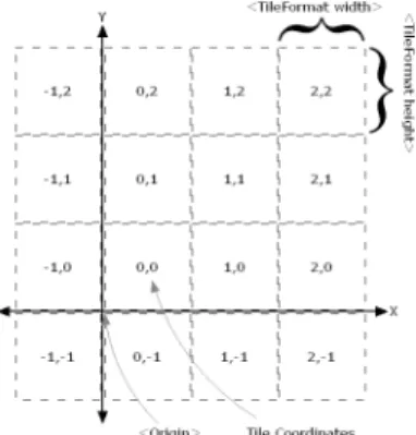
3.15 Tile map origin and coordinates scheme (source: OSGeo (2012)). . . 47
3.16 Tiles hierarchical grid arrangement (adapted from Xu et al. (2012)). . . 47
3.17 GeoWebCache Architecture (source: OpenGeo (2013b)). . . 49
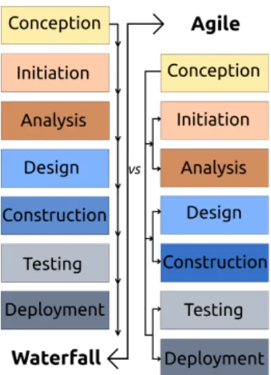
3.18 Waterfall vs Agile Methodologies (adapted from Prakash, Kumar, and Mishra (2013)). . . 52
4.1 National Atlas of Sports System Architecture (source: de Abreu Freire and Painho (2014)). . . 55
4.3 QGIS Project. . . 58
4.4 Tiles Production Schema. . . 59
4.5 Mock-up: Initial View. . . 61
4.6 Mock-up: Collecting View with Map Panel (BaseLayers). . . 61
4.7 Mock-up: Displaying Picture Panel over Form View. . . 61
4.8 Mock-up: Displaying Saved Records List and Map Panel. . . 61
4.9 ST Resources Content. . . 62
4.10 m-SportGIS: Start View. . . 64
4.11 m-SportGIS: Technician ID (“ID Técnico”) View. . . 64
4.12 m-SportGIS: Facility ID (“ID Instalação”) View and Select Field. . . 72
4.13 m-SportGIS: MultiListOverlay and MultiListOverlayItem Classes. . . . 73
4.14 m-SportGIS: MultiListOverlay Class in Sports Activities (“Modalidades”) Field Set. . . 74
4.15 m-SportGIS: Technical Features (“Características”) View. . . 75
4.16 m-SportGIS: Informations (“Informações”) View. . . 75
4.17 m-SportGIS: Example of Record Validation Alert. . . 76
4.18 m-SportGIS: List of Saved Records and Spatial Location View. . . 76
4.19 m-SportGIS: Data Edition (Saved Record) View. . . 77
4.20 m-SportGIS: Saved Photo Indexed to a Record View. . . 77
4.21 m-SportGIS Package Folder Structure. . . 78
4.22 m-SportGIS assets/www Content. . . 78
4.23 WebGIS: Displaying Sports Facilities Spatial Distribution. . . 79
4.24 Displaying Statistical/Demographical Analysis. . . 79
4.25 Displaying Sports Facilities Spatial Analysis. . . 80
4.26 Displaying Outputted Report. . . 80
4.27 Number of Collected Facilities by Month. . . 81
List of Program Listings
3.1 ST 2 Component (Fieldset) Code Fragment. . . 37
3.2 Script Tags to Load OpenLayers API and Google Maps API (version 3.X). 41 3.3 Instances and Methods to Create and Render a Simple OSM. . . 41
3.4 Instantiation of the Hybrid Layer of Google Maps. . . 41
3.5 Instantiation of Offline Layer . . . 42
3.6 Instantiations of OSM and Google Map and Layer . . . 42
4.1 m-SportGIS MainView. . . 62
4.2 Instantiation of Toolbar and Save Button. . . 64
4.3 Instantiations of Location Objects . . . 66
4.4 m-SportGIS Map Instantiation. . . 67
4.5 m-SportGIS Show Picture Function. . . 68
4.6 m-SportGIS Show Camera Function. . . 69
4.7 Submit all data records function . . . 74
B.1 m-SportGIS Loader Function (Ext.Application). . . 101
B.2 m-SportGIS StartView . . . 102
B.3 Tree List of Mozambique Administrative Divisions. . . 103
B.4 m-SPortGIS MultiList class. . . 104
B.5 m-SportGIS MultiListOverlay Class. . . 104
B.6 m-SportGIS MultiListOverlayItem Class. . . 105
B.7 Validations (rules) in Model. . . 108
B.8 Facility Controller. . . 111
B.9 Map Controller. . . 120
B.10 PictureView Buttons Functions. . . 126
B.11 m-SportGIS index.html. . . 127
B.12 Java Statement to Launch Cordova API. . . 127
B.13 Android Manifest. . . 128
C.1 Example of TileCache Configuration File. . . 129
C.2 Header Settings for Map Files. . . 130
C.3 Map Object Code Fragment in moz_3857.map . . . 131
1 Introduction
1.1 Background
Governmental organizations produce critical data about the nation’s population, econ-omy, services, and resources. These institutions are coming under increasing pres-sure, both societal and financial in nature, to develop and implement Information and Communication Technologies (ICTs), particularly Internet-based solutions, inside and surrounding their administrations. These emergent technologies (e.g. e-Government, e-Infrastructures or electronic public administration services) are being appraised as priorities in several activities by a majority of governments around the world, support-ing a new paradigm of society and modernization, committed to public service, maksupport-ing it more efficient, effective, transparent, more citizen friendly, and more capable of de-livering cross-agency public services (e.g. storage system and knowledge exchange) in an integrated way (Pollitt, Thiel, & Homburg, 2007; Soares & Amaral, 2011).
po-litical boundaries. All of this data can be combined, interrelated, and analyzed using GIS tools (Gaffney, 2002). Geospatial data articulated with other data sources pro-vides efficient means for planning, decision-making, and management of resources and activities in organizations, bringing forward cost savings, process quality, and efficiency increase. It is estimated that more than 80% of the data that population have collected so far constitutes geospatial data; this type of data is largely used in many aspects of socio-economic activities (J. Zhang, Liu, & Wang, 2010). ISs are instruments which assemble, store, process and deliver proper information to an organization or society, in such a way that the information is accessible and useful to those who wish to use it, including managers, staff, clients and citizens (Buckingham, Hirschheim, Land, & Tully, 1986).
powerful tools in Public Administration, developed with support of both traditional and new ICTs, contemplating a more extensive and intelligent mode of policy-making, holding a transformation effect on the structures, processes and functions of the public services (Donk & Taylor, 2000). Geospatial technologies, mobile computing, data stor-age and transfer, and the Internet are continuing drawing effective assets for a wide range of urban planning projects, assuming a relevant role in research and generate resources proceding from sources of field information. The mobility of the mapping systems has always been a concern. Mapping in a mobile distributed environment has been investigated and developed by researchers and engineers since the late 1980s, en-couraged by the availability of location-aware technology for civilian uses (e.g. facilities mapping) and concerns about the mobility of mapping systems. Mobile information technology has emerged from a combination of the Internet and wireless communication (J. Drummond, R. Billen, E. João, 2007). Mobile computing systems and hardware are experiencing significant progresses, and they are changing the way GIS is being used by moving GIS, in particular data collection tasks, from the desktop into the user’s hands, making the mobility an enticing aspect of GIS (Döner & Yomral, 2008). Mobile map-ping technology has evolved to a stage which allows geospatial industries to apply it in order to obtain high flexibility in data acquisition, more and richer information with less time and effort, and high productivity (R. Li, 1997). Handheld computers (e.g. tablet PCs) integrating location-based services, digital orientation, wireless communications, and sensing technologies, are useful equipments to gather geospatial data directly into a digital spatial environment, boosting field data collection in a more expeditious and operational way. Tablet PCs also bring the power to process data and disseminate it, including its storage, transfer, and synchronization in databases, and its combination with other data sets (Döner & Yomral, 2008). Others advantages of Mobile GIS are reflected in data integrity by validating it at the time of its registration. Mobile GIS can offer a user-friendly interface to its users (without GIS background), and can reduce transaction costs due to reduced errors at the source, faster communication protocols, and direct position recording. Mobile computing and mapping technologies are being exposed as an revolutionary and low-cost solution for data collection in a range of sci-entific backgrounds (Aanensen, Huntley, Feil, Al-Own, & Spratt, 2009; Chen & Xiao, 2011; De Donatis & Bruciatelli, 2006; Green & King, 2004; Lane, Miluzzo, Lu, Peebles, & Choudhury, 2010).
1.2 Problem Statement and Motivation
Throughout this century there has been a trend towards a decrease in the amount of research into field data collection. In developed countries is comparatively easier to gather data than in developing countries. The lack of rich data (including spa-tial data) available is more notorious in these last ones due to both, geospaspa-tial data infrastructure policies, and high cost of conventional data collection and data process-ing methods (Montoya, 2003). The existent need of reliable infrastructure, competent tools, ubiquitous connectivity, and proper expertise makes data collection operations very arduous. The ability to handily interact and process raw data enables individuals and organizations to effective create information crucial to plan and manage services and resources, and make better decisions. Most of the current organizations collect data using traditional methods — paper forms — facing their inefficiency issues, such as data inputs errors, time consuming and inconsistency in data transcription, and long delays until information about that data is available (Anokwa, Hartung, & Brunette, 2009). Consequently, particularly in developing countries, and in the spatial informa-tion sphere, when a project specificainforma-tions require advanced informainforma-tion, organizainforma-tions actually realize the real importance of carrying on modern, cost effective, and appro-priate data collection solutions in field operations (mobile mapping) (Döner & Yomral, 2008; Montoya, 2003). In developing regions, the actual expansion of mobile technology usage, and improvement of technological infrastructure is inciting high motivation to use that technology, expecting to overcome current deficiencies in data availability.
In Mozambique, the current governmental technical situation lacks of a platform to plan and manage sports activities and venues (facilities, infrastructures), and to share relevant information with communities and stakeholders (Républica de Moçambique, 2002). In this sense, Mozambican sports bodies demand a cost effective solution to gather detailed data including spatial attributes, customized with sports specifications. This mapping solution should meet the needs of MJD in terms of usability, data in-tegrity, maintenance costs, and information details.
1.3 Objectives
The main goal of this project is to develop a location-aware mobile software app — m-SportGIS — as a vehicle to create an inventory of sports facilities. This data is a crucial source to allow sports data analysis, planning, and management in the MJD. The project research involves analysis and implementation of low-cost resources to build the mobile software solution, targeting tablet PCs (and smartphones) running Android operation system. That solution will be a pioneer tool to the Mozambican Govern-ment, capable of collecting, validating, storing, editing, visualizing, and transferring data (alphanumeric and media) processedin-situ (field). Afterwards, stored data (in a server database), together with statistical data from National Statistics Office (“Insti-tuto Nacional Estatística” (INE)) of Mozambique, are the data sources of a SDI with spatial functionalities (analysis and edition tools). To face m-SportGIS development life-cycle, and regarding the achievement of a successful product, the research of ade-quate methodologies and approaches to software development in organizations can be very valuable, since they propose adequate software development standards. To build a handy system and functionalities is necessary:
• research, evaluate and identify the feasible and suitable OS technologies and tools to develop a mobile app (with mobile web technology);
• research on feasible hardware resources requirements;
• research and develop a spatial framework interface and the process of location-based service to work on both conditions, online and offline map service;
• design the app architecture and components; • create an aesthetic GUI;
• implement a data insertion and validation process, and a data storage method; • implement a data transfer service technique;
• build a prototyping and testing procedure for the app; • create an app manual.
1.4 Assumptions
The conception, development and implementation of this project is conducted based on the following assumptions:
• The institution MJD is capable to effectively utilize the acquired knowledge, which is a condition of access to information, and it drives to attain competitive advantage;
• Free and Open Source Software (FOSS) technologies provide a low-cost software development solution, namely in what concerns to software licensing costs, and it constitutes the software option to deploy this app;
• The app takes an aesthetic GUI being really intuitive to involved operational-level staff, who probably lack of experience and knowledge in new hardware/mobile equipments and GIS technologies;
• The institution stakeholders own suitable resources/hardware for the surveying works, and system stakeholders have training to make good use of the resources; • The Internet and mobile wireless broadband technology is available for
commu-nications and data exchanges, at least in the government installations.
1.5 General Project Methodology
To conduct the development of the software app, a research on GIS data collection methods and tools was undertaken. Inside this field the use of mobile digital technol-ogy and location-based services was studied. Considering these approaches, a research on mobile GIS collection in sports inventory systems was reviewed, and a research on sports spatial planning was undertaken. To implement m-SportGIS using low-cost re-sources, web, mobile, and spatial development frameworks were analyzed. Regarding Android devices specifications, where the app is being installed, requirements of native functionalities accessed using web based code was also analyzed. For the map interface, both online and offline spatial services and servers were studied; in this field, attending to the offlline capabilities, the conception of cache mechanisms were analyzed. Con-cerning the development and implementation of software in the core of a governmental organization, convenient methodologies in information systems development were ex-amined and an approach was considered to hold the life-cycle of the app. Before the development of m-SportGIS, a market research of current mobile GIS mapping and apps was undertaken. The app development contemplated system requirements anal-ysis, data production, code production, implementation and testing stages. Project is concluded commented final considerations, and further developments.
1.6 Structure
The project comprises five chapters and reflects the investigations and works taken to accomplish the intended goals of the current dissertation work (Figure 1.1).
the m-SportGIS solution and its main objectives are enumerated. Furthermore, as-sumptions for the deployment of the software app are bringing forward. This chapter ends with a presentation of the general work methodology, followed by a delineation of the project structure. In the second chapter, GIS data collection and mobile GIS technology concepts are reviewed, together with its advantages in sports facilities data collection and information management. The chapter ends with a description of the mobile GIS mapping state of the art, enumerating data collection apps in use available in the market. The third chapter explores technologies, frameworks, and mechanisms to build mobile apps and mapping services. Particularly it is presented different mobile software development approaches, and it exhibits different mapping implementations to serve spatial data to the user. This chapter ends with a review of software devel-opment methodologies in organizations, focusing on web-based systems contributions to the modernization of the information platform in governmental bodies. Then, it is presented an adopted methodology for m-SportGIS development. The fourth chapter comprises all the development stages undertaken to produce the mobile mapping solu-tion, from system requirements analysis, data preparation and processing, coding, and production. In this chapter it is also presented an overview of the integrated GIS system — mobile component, server component, server database. It also presents sports data statistics in Mozambique, showing the effective impact of m-SportGIS usage inside the organization. The chapter ends with considerations on the app implementation. The last chapter includes project conclusions and contributions regarding the success of the work, presenting advantages and limitations of m-SportGIS, stating also suggestions for further developments.
2 Mobile GIS Data Collection in Sports
Inventory Systems
2.1 Introduction
Over the last decade, mobile computing systems had made significant progress, and the enhancement of technologies such as the Internet, telecommunications, GPS and mobile computing devices are changing the way GIS is being used, by moving GIS from the desktop into the field user’s hands, and making the mobile an enticing aspect of GIS. The potential of mobile GIS and others mobile computing methods to add superior value to support efficient scientific data acquisition and management is widely acknowledged (Döner & Yomral, 2008; Wagtendonk & Jeu, 2007). Mobile-computing technologies in GIS distributed environment are progressively becoming the means for capturing and visualizing electronic spatial data in a variety of technical and socio-economic sectors. GIS products are now used in a large number of apps that deal with spatial data to drive socio-economic planning, marketing analysis, facilities management, and environmental assessment (Longley, P., Maguire, D., Goodchild, M., Rhind, 2011).
Traditional data collection using paper forms and maps meant overlong streamlined work-flow, from data collection, to post-processing (e.g. evaluation) to make spatial information available, leading to a low data service life. Too many processes vulnerable to produce errors were implicit, reducing quality and accuracy of data, hindering data quality control (Chen & Xiao, 2011; Yan, Yu, Wu, & Ma, 2009). The need to explore new ways of data collection has been actually a crucial matter.
2.2 GIS Data Collection
Data collection is recognized as one of the most time-consuming, expensive and error-given tasks in any GIS project. It is common that technicians and researchers use a mix of survey instruments, maps, and paper-based forms to acquire geospatial and attribute data in geosciences fieldwork (Wagtendonk & Jeu, 2007). Regardless of conventional fieldworks methods have proven to be adequate in different inventory and monitoring operations, a crescent community of scientific researches suggests that the use of hand-held computers, mobile GIS, and related mobile location technology (e.g. GPS) has several distinct advantages in comparison to traditional paper and data entry collection techniques, improving process efficiency, integrity, and capacity (Aanensen et al., 2009; Tamelen, 2004; Wagtendonk & Jeu, 2007). This is especially true in developing coun-tries where current collection and analysis of administrative data are rare and limited due to poor infrastructure and organization (Seebregts et al., 2009). Often, data input on paper-based forms is unstructured and stored values are corrupted. This problem induces errors, data quality issues, inconsistencies, and workload burden during data transcription to digital formats.
There are several sources of geographic data, and different methods are available to enter them into a GIS. The two main methods of data collection are data capture (direct data input) and data transfer (input of data from other systems). Mobile mapping software is usually explored for direct input data, but it is able to handle with both methods; it is important to identify the type and source of data produced from mobile devices. Scientific studies and governmental administration require large scale data and associated attributes (R. Li, 1997). This constitutes one more important reason to adopt mobile GIS tools in spatial data collection.
The largest mobile mapping benefits come in the post-processing phase, where all those traditional data methods and techniques are overcome. A Strengths-Weaknesses-Opportunities-Threats (SWOT) analysis of mobile computing methods for fieldworks has been addressed by Wagtendonk and Jeu (2007), taking into account their success and added value in the long term (Tabela 2.1).
In this process of adapting technology to assist planning and management, it becomes essential for technical staff enrolled with the project, understand the reliability of using the technology to collect data, compared with pen and paper methods, and the steps that can be taken in programming mobile computers to aid in the collection of reliable data (Guadagno et al., 2004).
GIS Data Collection Participation: Empowering People
informa-Strengths Opportunities Data collection efficiency (e.g.smart menus) Wireless information retrieval
More objective data collection Real-time streaming of field data Minimized post-processing time Monitoring and virtual supervision
Spatial and attribute accuracy Dynamic changes to data collection strategy Real-time error control and validation Seamless integration of post-processing work Searchable access to field materials Faster field data distribution (handy GUI) Wireless integration with other devices
Weaknesses Threats
Complex system development (specific skills requirement) Non well-trained field operatives
Development, implementation, and maintenance costs New risks (data loss) in its transfer and integration Vulnerability of equipment Lack of resources for regular system updates
Growing technical dependency
Table 2.1: SWOT Analysis of Mobile Computing Methods for Field Mapping (adapted
from Wagtendonk and Jeu (2007)).
tion technologies, conceiving new schemes of representation and new ways to address significant questions to society (John Wilson and Stewart Fotheringham, 2008). Current mobile technology tools such as tablet PCs/smartphones empower potentiali-ties for data collection, extending spatial planning and GIScience to groups of people to participate in technological projects and decisions, contributing to develop their com-munities and promoting improvement of public services (Devisch & Veestraeten, 2013). Participatory methods are mentioned as an attempt to utilize GIS technology in the context of the needs and capabilities of communities that will be involved with, and affected by development projects and programs (Kienberger, 2001).
2.3 Mobile GIS Technology
We live in a networked society founded upon modern ICT linking computers with com-puters, computers with individuals and between individuals on an unprecedented scale. Mobility is a revolutionary phenomena that has transformed the way we work, perceive, and access information. The most important current trend in the software development world is, without a hint of a doubt, the mobile frontier, and in particular, the rise of the smartphone and the touch tablet PC (Kosmaczewski, 2012). Increasingly powerful mobile devices, their ability to be location-handled, mobile computing, and the rapid growth of high speed networks, are expanding the possibility of employing information and their content based on the location, to support organizations establishing services and products for the information community.
Yomral, 2008). Others advantages of Mobile GIS are reflected in data accuracy through the validation at the time of data registration, reduction in transaction costs due to errors minimization at the source and faster communication protocols, direct position recording, and user-friendly solution for the field workers.
Goodchild in Longley, P., Maguire, D., Goodchild, M., Rhind (2011) exposes an inter-esting perspective on the implications of GIS becoming more distributed, based upon four different locations: the location of the GIS user and user interface (UI), denoted by U; the location of the data being accessed by the user denoted by D; the location of data processing, denoted by P; the area/field site that is the focus of a GIS project, denoted by S. Traditionally, in GIS projects U = D = P 6= S, this is, the UI, the
data, and the data processing all occur at the same location, this means they occur at a laboratory rather than at a field site. In the new era of distributed and mobile GIS, it is possible for U 6= D 6=P =S, that is, the UI, the data, and the data processing can be materialized at different locations, and some or all of them can take place at the field.
As the technology has become more affordable, portable, and easier to use, together with innovations in hardware (programmable mobile phones) and software, the smart-phone has lead as the universal mobile telecommunication computing technology, world-wide adopted by a world-wider community of professional users (e.g. social science re-searchers), as a tool for collecting data, and accessing information on the move (R. Kwok, 2009; Raento, Oulasvirta, & Eagle, 2009). As a reflection of advances in mobile technology, mapping industry has been developing mobile GIS software (e.g. GeoCol-lector for ESRI ArcPad system) to simplify capturing, editing, and displaying location-based data more conveniently. In the recent years, significant advances have taken place in GPS technology for the compact portable electronic containers such as tablet PC, specially in terms of integrated positioning, navigation, and timing. The ability of tablet PCs to run rich mapping software apps, and to position themselves, allow field technicians to capture spatial information in real-time and real-space.
2.3.1 Tablet PC and Smartphone Technology
1/4G LTE2 connection support, a music player, and several others features such as
GPS antenna, digital compass, digital camera, microphone, accelerometer, gyroscope (sensors of motion, vibration, and orientation detection), and touch support. These kind of embedded features make smartphones capable handheld devices able to process geospatial information. The same author defines a tablet PC as a touchscreen flat device (7 to 11 inches size range) running a mobile operating system (such as i-OS in-stead of Mac-OS), or a touch-optimized version of a desktop operating system (such as Windows for tablets instead of Windows Phone), holding WiFi support and/or 3G/4G connections. These devices (later to the iPhone 2007) are open and programmable com-puters affordable by third party developers that can make use of cross-compile code and existing software such as JavaScript (JS) libraries (e.g. Ext JS, jQuery, Dojo) to support apps development. The hardware is controlled by powerful operating systems (e.g. Android, Apple iOS, Mobile Windows) supporting the apps community with Software Development Kits (SDKs), APIs, and software tools.
Mobile devices are much more efficient in the form factor (size, shape, weight, etc.), chip type, internal storage capacity, battery lifetime and operating system compared to conventional computers. Along with hardware development, the operating systems running on these devices are becoming more compact and functional (Lane et al., 2010). Thanks to them and to the sensing, positioning, computing, and communication functionalities incorporated in tablet PCs, we are breathing an emergence boost of personal, group, and community-scale geospatial apps (Lwin, 2011).
Economic factors around location services and products and the versatility (programma-bility) of tablet PCs are greatly enhanced by the availability of OS code for software developers to produce and deploy their own apps directly on the devices. OS technolo-gies concede the use of their source code for the development of proprietary and/or free software apps. OS manufacturers like Android/Open Handset Alliance3 provide open
and free SDKs to user community to develop, modify and distribute custom software apps to be run on the mobile platform. In addition to the variety of data — text, pho-tos, location, audio, video, barcode scans — that can be collected, mobile platforms have proven to be definitely faster at both, collecting the data and making it available to project planners and decision makers (Anokwa et al., 2009).
Mobile Communication
People lean to use their mobile devices just about everywhere, however mobile networks are not always there to support them, even when they are, coverage can be expensive and sporadic. Developing for mobile means designing for this reality. Despite the fact that tablet PCs are evolving in sophistication, and developments within mobile and
1CDMA: Code Division Multiple Access standard
2LTE: Long Term Evolution standard
web technologies provide the opportunity to expand approaches in new data collection, visualization and analysis, it is presumable to notice hardware resources constraints and challenges when developing embedded features in those equipments. It is important to focus on defining specific mechanisms and use whichever client and server-side tech-nologies available to improve the efficiency of data processing, taking into account that typically mobile devices have to rely on communication technologies, namely user posi-tioning system and wireless connection for data interchange/interoperability (Sumrada, 2002; Wroblewski, 2011). Sending and receiving data using wireless Internet connec-tions (3G/4G/Wi-Fi) introduces a variable amount of latency due to the nature of network nodes/points (stationary or dynamic stage) that can be very unpredictable. Mobile devices typically know intermittent connectivity to the network, much more ev-ident in developing countries, where the services offered on a mobile device may only be accessible occasionally. Therefore any client-side app (e.g. m-SportGIS) that interacts with communication services on mobile platforms needs to be designed to operate in an opportunistic manner, leveraging such services when they become available (Berger, Mcfaddin, Narayanaswami, & Raghunath, 2003).
Positioning: Global Positioning System (GPS)
system, achieving through its usage position accuracy averages of 10 m (GPS), 30 m (Wi-Fi), and 500 m (cellular). Most tablet PCs and smartphones models are GPS-enabled, making them handy mapping tools in several GIS-based projects.
2.4 Spatial Planning for Sports Venues Management
MJD sets clear expectations regarding country sports planning by “providing the right facilities in the right places”. “Spatial planning goes beyond traditional and use plan-ning to bring together and integrate policies and programmes, which influence the na-ture of places and how they function” (Sport England, 2005). Spatial planning states for the physical aspects of location and land use, but also factors that make places attractive to live in: health provision, public services, employment opportunities, en-vironmental quality, crime prevention, etc., and a wider, more inclusive approach to decision-making (Figure 2.1).
Citizen access to sports education and activities is a right established in the Mozam-bique constitution. The search of opportunities to participate in sports infrastructures and facilitates sustainable development is recognized as fundamental to the health and well-being of communities. MJD, working together with partners, seeks to engage planners and technicians at regional and local levels, to ensure that interests relying on sports and its recreations are well represented, promoted, and developed, attending to the interests of all, including the aspirations of its partners in public, private and voluntary sectors (Républica de Moçambique, 2002).
MJD, alike others developed sports organizations (e.g. English Sports Council4), aims
to ensure a good spatial planning for sports venues (facilities, infrastructures) based on prosperous assessments of needs for all levels of sports and all sectors of the community. This analysis allows to identify opportunities to plan new resources and services that meet the current and future demands to sport participation (England, 2013). Spatial planning involves partnership through the development of shared aspirations, and a willingness to make creative use of land use planning in combination with a range of other policy instruments, such as community strategies.
The commitment view of these organizations intend, in addition to hold a sports system, provide organizational, planning, and regulation measures (legislation), promote sports evolution, ensure the existence (and good management) of sports venues of quality, improve quality and performance of top-level sports, and promote intra and inter-institutional communication and cooperation. Tabela 2.2 shows registered outcomes of implemented sports planning projects in socio-economic domain.
m-SportGIS constitutes the primary tool to support the spatial planning system. Ac-cording to the German Federal Institute of Sport Science — BISp5 — and Cadima,
4sportengland.org
p p
Spatial Planning
Community Safety
Local Economic
Viability
Quality of Life and Well-Being Raising
Standards in Schools
Health Improvement
Environmental Sustainability
Figure 2.1: Principles of sports spatial planning (Sport England (2005)).
Themes for Spatial Planning Outcomes of Sport and Active Recreation Innovations Environmental sustainability Increasing participation on sport and active recreation
Community safety Improving levels of performance Local economic viability Widening access (new opportunities for people) Improving quality of life and well-being Improving health, and social and cultural well-being
Health improvement Stronger and safer communities Raising standards in schools Improving education
Benefiting the economy (sustainable growth) Efficient use of resources
Table 2.2:Sport framework: spatial planning activity and outcomes of innovation
(adapted from England (2013); Sport England (2005)).
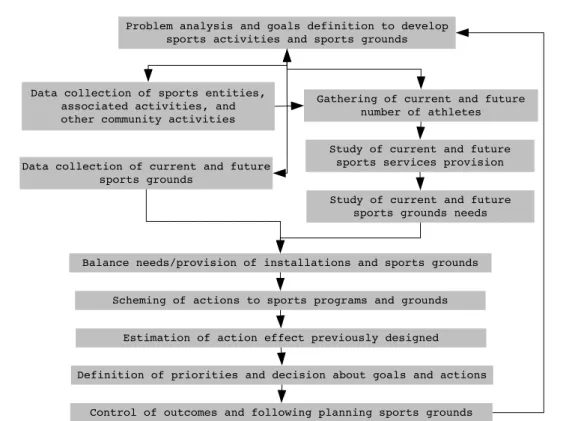
Fernandes, Viseu, Parente, and Brito (2002), an essential duty in the management of in-stallations, sport grounds, and recreational areas leads to research and inventory useful data about the current and intended type and number of sport venues. Further, is also important to take into consideration policies on sports practice trends of population, besides the provision of services by clubs, organizations, Olympic Committee, and oth-ers public and private institutions (Républica de Moçambique, 2002). The BISp also notice that the sports practice is only experienced if there are available installations and appropriate sports grounds conditions.
Problem analysis and goals definition to develop sports activities and sports grounds
Balance needs/provision of installations and sports grounds Data collection of current and future
sports grounds
Study of current and future sports grounds needs Gathering of current and future
number of athletes Data collection of sports entities,
associated activities, and other community activities
Study of current and future sports services provision
Estimation of action effect previously designed Scheming of actions to sports programs and grounds
Control of outcomes and following planning sports grounds Definition of priorities and decision about goals and actions
Figure 2.2: Guidelines for sports grounds planning (adapted from Sportbuchhandlung
(2000)).
2.4.1 Projects in Sports Data Collection
In a research study about citizen access to sports activities in Portugal, Cunha (1997) mentioned that the sports domain is defined based on criterion, such as the identifica-tion of particular goals that leads to agents’ acidentifica-tions and deal with the processes and activities, the existence of an organizational structure where sports actions are planned and practice, the presence of agents as human resources and athletes to manage pro-cesses and take them into action, the recognition of the target population depending on the way they live the sports sphere, and the statement of the organizational processes associated with an established board of activities.
To build a very complete sports venues attributes inventory for the MJD, it became necessary investigate what sort of specifications sports agencies consider relevant to embody in a field census report. Analyzing some sources about projects carried out by Portuguese organizations, such as INATEL6 and Porto de Mós County7 (Instituto
Português do Desporto e Juventude, 2012), and information about the African Olympic Games (Maputo, 2011)8, made possible to create a list of sports venues characteristics.
This information was the base to develop a structure of sports data in m-SportGIS
6www.inatel.pt/content.aspx?menuid=21(accessed on 22 October 2012).
7www.municipio-portodemos.pt/page.aspx?id=24(accessed on 30 October 2012).
(Tabela A.4).
Recreational Areas
According to Cunha (1997), sports industry legislation classifies the facilities type based on its sports activities as recreational, educational, specialized (for competition), and specific for sports entertainment. The first type of facilities intend to shelter sports ac-tivities as leisure practices; the second consist of infrastructures conceived to organize sports education trainings (e.g. large football field, sports hall, swimming pool) at-tending to reach competition levels; the third type of facilities coordinate a selection of specialized activities (e.g. golf field, canoing site); and the fourth type are special facil-ities that associate specialized activfacil-ities with entertainment components (e.g. stadium seating, social media sites, and technology).
2.5 Mobile GIS Mapping: State of the Art (Related Work)
mining industries, to provide basic geological materials (information from accurate raw data) for territorial planning, mineral exploration, engineering geology, etc. (Chen & Xiao, 2011; De Donatis & Bruciatelli, 2006; Jones, McCaffrey, Wilson, & Holdsworth, 2004). In forest management inventory, where conventional data surveying and pro-cessing methods need high-intensity labor force, but with low accuracy due to large amounts of data involved, forestry science workers pay close attention to mobile map-ping, which shows remote sensing images and vector maps on the device, and displays the current position of the user in the vector and grid map. Mobile GIS supports a modern electronic governmental forestry service — e-forestry — integrating automatic mapping and warehousing (Dong, Liu, Wang, & Chen, 2010; C.-g. Li & Jiang, 2011). In the context of participatory planning projects (e.g. National Spatial Data Infrastruc-ture), US citizen communities employ smartphones to register, mapping, and tracking almost anything that is conceivable with importance for location analysis; smartphones are perceived as “networked mobile personal measurement instruments”. Projects re-lying on this technology are thus referred to as second-generation “citizen science” or m-citizen science (Devisch & Veestraeten, 2013).
2.5.1 Employment of Handheld Devices in Mapping
Scientific research investigating the use of tablet PC/smartphone technology to gather field data collection is relatively novel. Digital surveying of facilities is not know yet. In this sense, the research has been taken analyzing the use of mobile mapping in different backgrounds as mentioned before. An investigation about mapping apps for smartphones disclosed examples such as EpiCollect9, and Magpi10, in environmental
studies. The IBM Almaden Research Center has designed an iPhone app — Creek Watch11 — to monitor watersheds, where users with the phone’s GPS enabled, take a
photo and submit crucial pieces of data based on observations (IBM, 2010). The Center for Embedded Networked Sensing at the University of California, has also developed an Android app to locate invasive species in Santa Monica mountains, by making geo-tagged observations and taking photos, to study the spread of habitat-destroying by invasive plants and animals (What’s Invasive12) (The Center for Embedded Networked
Sensing, 2010). Computer scientists at the University of Washington have launched an Android app — Ultra Mobile Field GIS — to acquire georeferenced data of public facilities (e.g. bicycle stands and their capacity, car parking lots, and illegal garbage dumps) to assist administrators in maintaining the campus landscape and managing the student facilities (Lwin, 2011). Docking special sensors to smartphones have also been conducted to run environment-centric apps (e.g. Haze Watch13) in Australian urban
9epicollect.net
10magpi.com/login/auth
11creekwatch.researchlabs.ibm.com
12whatsinvasive.org
3 Hybrid Mobile Development, Mapping
Mechanisms, and Software Development
Methodologies
3.1 Hybrid Mobile Development
3.1.1 Thinking Mobile
storage, network connectivity, multimedia, sockets and threads, drawing and anima-tion, and advanced form controls (Kosmaczewski, 2012). The growth in power of the mobile web is bringing innumerable possibilities, particularly in developed countries where smartphones/tablet PCs constitute an economical way to access and collaborate with online data and services.
3.1.1.1 Designing Mobile Content
The power of the apps comes from people’s ability to not only view and consume con-tent, but to contribute and create content as well; input on mobile is just as important as output. Managing data and displaying it on a screen employing UI framework wid-gets constitutes a prime way to users interact with data. A mobile user has a different context than a desktop user; field sets on mobile platform come with their own set of constraints and capabilities that delineate how they should be conceived. Working with UI objects for this platform requires special considerations regarding their layout due to the restricted screen size, and how much data inputs the app needs to handle; for instance, design how nested objects must be rendered to be accommodated in a touch-capable mobile container, where a virtual keyboard pops-up and takes part of the room available on screen. Developing forms represents a common task in every app developer’s life. Create forms can be a dull subject, both for the user, who is filling them out, and for the developer, who creates them. Depending on the type of field and data required, different types of input fields for mobile browsers can be used. The mobile device serves as a blank canvas for interactive elements; optimizing mobile labels means take advantage of new input types, attributes, and masks to make mobile input easier than ever, choosing handy layouts for sequential, non-linear, and in-context forms, and tuning input field using mobile device capabilities (Wroblewski, 2011). Considering how touch gestures are used to navigate and interact with objects and screens promotes new ways to create content affording natural user interactions, and therefore appropriate mobile on-hover menus and transitions (Firtman, 2013; Pilgrim, 2010; Williams, 2012).
3.1.2 Mobile Applications: Native vs. Web vs. Hybrid
which libraries can they use to speed up the development, and what level of standard support holds the major mobile browsers (Kosmaczewski, 2012). Building mobile web apps offers us browser-based apps and advanced features consigned to full-screen or native web apps (e.g. Wikipedia app), using native web APIs such as Cordova1 (
aka. PhoneGap2) (Firtman, 2013). An API works as an interface for developer’s code,
in-cluding commands (working as methods) rendering the more complex stuff that is done in the background or by third-party software. The deciding factors regarding one or another development approach are, ultimately, the user’s requirements and expecta-tions from the mobile solution, developer’s capabilities, project specificaexpecta-tions, available tools, administrative and security concerns, budget, time-lines, and long-term goals.
3.1.2.1 Native Applications
Native code-based apps run “natively granting the best access to the capabilities of the device (e.g., camera, file system, accelerometer) — handling the actual UI behav-ior — assuring the best UX (e.g., motion gestures recognition), and mobile web apps (browsers) do not. Native mobile apps respond 10-15% times faster than web apps, offer higher security, and are more customizable. Table Tabela 3.1 shows pros and cons of native app implementation. Nevertheless, based on mobile software development experiences, programmers cannot reuse the UX — analysis, design, implementation, deployment — from a specific device when they are creating an app for another. Op-erating systems — iOS (App Store), BlackBerry (App World), and Android (Google Play Store) — require skills of expert programmers in a specific mobile vendor SKDs and IDEs to deal with its own conventions which its users expect. When the IT team is deploying an enterprise native mobile app for one platform — distribution/installation through mobile app stores (e.g., Google Play, App Store, App World) — chances are it will not be able to create one for every platform, due to the cost of maintaining them — Apple’s iOS demands Objective C; Google’s Android relies on Java; Microsoft’s Windows Phone 7 requires Silverlight; Samsung’s Bada needs C++; Blackberry uses Java, WebWorks, and Adobe Air solutions (Fowler, 2012; Williams, 2012). The per-formance judgment that native apps are faster can take relevance when they require large amounts of graphics processing, Central Processing Unit (CPU), and Random-Access Memory (RAM) (e.g.,3D games or image-processing), but there is a negligible or unnoticeable performance penalty in a well-built business app using web technology (Charland & Leroux, 2011).
3.1.2.2 Web Applications
The mobile web, from a user’s perspective, falls essentially in web content accessed from a mobile device (mobile-optimized web browsers); from a developer’s perspective,
1cordova.apache.org
Pros Cons
Full access to mobile device features Longer development cycle
Deep integration capabilities Non-portable code
Deeper security implementations Expensive development andsupport
Highly responsive and smooth performance
Accessibility via app stores (control, restriction, submission
and update approval cycle)
Rich UX / Performance Needs skilled developers of nativecode for every mobile OS
Easy installation and payments Superior customization
Table 3.1:Native mobile app: pros and cons (source: Boston Technology Corporation
(2013)).
the mobile web it is a group of best practices, design patterns, and new code (Firtman, 2013). iPhone’s launch (2007) brought forward the best way to experience the mo-bile web due to the Momo-bile Safari built on top of a WebKit operating system platform (David, 2012). Web technology communities such as Mozilla Foundation3 have been
changing the restrictive native apps abilities in terms of hardware features access, and addressing the balance in favor of web standards. Tabela 3.2 depicts the main pros and cons of web app development. Contrasting with the web apps of yesterday which were not tied to the operating system and capabilities of hardware, developers are now required to create apps to be compatible across browsers, platforms, and devices (e.g., Android’s WebKit-based browser). WebKit is a lightweight, yet powerful, rendering engine browser, emerged out of the KDE project’s HTML layout engine KHTML4 and
JS engine KJS5
, and further implemented by Apple in Mac OS X with the help of an adapter library and renamed WebCore and JavaScriptCore(Ubuntu, 2008). Its explo-sion comes from the fact that it powers many of the leading mobile platform browsers (e.g., Chrome, Dolphin, Safari, Opera). The core feature of WebKit is its support to HTML5, adapting the latest W3C specifications as they are published (Hales, 2013). As of Mid-2013 its market share6,7 is evidently in the edge of both engines used by
Internet Explorer (IE) and Firefox (Trident and Gecko, respectively). Respecting to current most popular and flexible mobile operating system — Android — and bringing forward its native APIs available to web developers, through JS APIs, the Web com-munity can potentially reach into the same APIs available to native app developers (Williams, 2012).
HTML5, CSS3, and related cutting-edge technologies are very well supported in many
3mozilla.org
4en .wikipedia .org/ wiki/ KHTML 5en .wikipedia .org/ wiki/ KJS( KDE)
6gs.statcounter.com/#browser-ww-monthly-201210-201310
mobile web browsers8. Technical capabilities like location detection, device orientation,
offline storage, forms, and touch events are available on many mobile web browsers today. Figure 3.1 presents a capability scope comparison between web and native apps. These features enforce programmers to definitely act about how users are handling apps throughout their activities. An advanced mobile web app can play a really interesting role as a portable platform; device manufacturers do the work of carrying on the web platform to their device, ensuring a good UX that is consistent with other web apps on that device.
Pros Cons
Lightweight solution / Powerful technology Slower performance than native
solutions
Reusable and scalable code Limited offline functioning
Web developer expertise Limited multimedia support
Inexpensive coding and deployment Cannot leverage all native OS
features Can be freely accessed / Vendor
independence
Cannot replicate native touch-and-feel Shorter time-to-market (develop,
distribute and update) Mobile browser incompatibility
Inconsistent rendering across browsers
Table 3.2: Mobile Web App: Pros and Cons (source: Boston Technology Corporation
(2013)).
Figure 3.1: HTML5 vs. Native features scope
(icapps.com/html5-vs-native, accessed on 4 October 2013).
3.1.2.3 Hybrid Applications
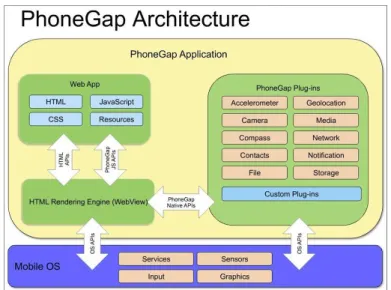
A Hybrid app is part native app, part web app (aka. native web app). It is effectively a web app, but hosted inside a native app container (full-screen WebView). The app is developed with web technologies — HTML5, CSS and JS — and packaged and compiled as a native app. This blending makes it mobile platform independent (Figure 3.2). It is installed, launched and used like any native app. This approach relies on native-to-the-device capabilities offer by web-to-native wrappers such as Cordova/PhoneGap which communicate between JS and native code, either one way or bidirectionally (Boston Technology Corporation, 2014; Firtman, 2013).
Figure 3.2: Hybrid Capability = Native + HTML5 Aptitutes
(wiki.developerforce.com/page/Wiki, accessed on 27 September 2013).
Going Native
Native mobile apps can be built taking advantage of native APIs, such as Cordova / PhoneGap, capable of delivery native apps for multiple platforms. Cordova has been developed by Adobe and Nitobi, under Apache License Version 2.0, and allows devel-opers to create native-like apps using web technologies. It provides a JS-based API with device-specific native backing code (cordova.js and cordova.jar) that works in par-allel with the Software Development Kit (SDK) of the target platform (e.g., Android SDK Tools9, iOS SDK10), granting to mobile web developers access to device built-in
functionalities (e.g., media/camera, local storage, file system) from the client JS code Apache Cordova (2013). Figure 3.3 depicts a native web app built upon its structure. Often, organizations build hybrid apps looking to get a presence in the app market without spending significant resources and costs. “About 70-80% of our code can be reused across apps. That saves us a lot of time and a lot of skill. It is very hard to find different native skills and combine them in one team, but it is comparatively easy to educate people in JS (Appcelerator, 2013; Williams, 2012). Setting up a software de-velopment environment, incorporating a UI framework such as ST11 or jQuery Mobile
9developer.android.com/sdk/index.html
10developer.apple.com/library/ios
(jQM)12, and a native API, a native-like app can be developed with web technologies
(HTML, CSS, and JS) (Figure 3.4). Taking these tools, the same code components can be reused on different mobile operating systems (iOS, Android, Blackberry, Windows Phone, Palm WebOS, Bada, and Symbian) with few minor changes, reducing the devel-opment costs (Budiu, 2013; Cowart, 2013). Others popular mobile cross platform tools are Titanium13and Xamarin14(Wayner, 2013). Attending to the hardware held by the
project client, the Integrated Development Environment (IDE) was set up focused on the Android Cordova branch.
Figure 3.3: PhoneGap Architecture (source: slideshare.net/loianeg/curso -phonegap-cordova-aula-01-introduo-ao-phonegap)
Application (m-SportGIS)
Others
Android iOS Blackberry
Web View
Multiple Mobile Web-Based App Framework (e.g. Touch)
Native API's (e.g. PhoneGap)
Figure 3.4: Mobile Web-based App Framework Structure (adapted from Williams
(2012)).
3.1.3 Designing JavaScript-Driven Mobile Applications
Mobile JS-driven apps refer to browser-based software created for handheld devices which can be connected wirelessly. Mobile devices hold relevant differences between
12jquerymobile.com
13appcelerator.com/titanium
each other in terms of performance characteristics. The success of any mobile web app depends on two factors: design and performance. Web-based standards assist well mobile apps relying on dynamic data, as it can use Asynchronous JavaScript and XML (Ajax) to quickly deliver content to the app over the network. It can also cache and store data to be used offline when there is no network connectivity (Williams, 2012). Improvements in the app’s performance rely on offline capabilities, animations on the UI, and backend services that retrieve and send data via RESTful or WebSocket end-points (Hales, 2013). Minimizing network connections and the need to transmit data — efficient media handling, effective caching, and employing longer data-oriented oper-ations with fewer connections — is undoubtedly one of the best ways to improve mobile performance (Kosmaczewski, 2012). Leverage Web Storage15 (
aka. Local Storage or Document Object Model (DOM) Storage) to store objects (i.e. HTML, CSS, and im-ages) in the background can yield an alternative and better UX — twofold conception: the more that can be done on the client-side, the fewer trips across the network and the better UX provided (Google Developers, 2013c; Matsudaira, 2013; Sencha Inc., 2011; Zakas, 2013).
JS engines on mobile browsers (e.g., WebKit) focus on the idea of sending the “right” data across the network, keeping code small both in size and execution time on mobile devices regarding performance cost (Google Developers, 2012; Matsudaira, 2013). As concerns the UI and hardware-acceleration, CSS code should be preferred for graphics presentation and effects, since it can be handled by graphics processing unit (GPU) of the device (Kosmaczewski, 2012). ST libraries offer the best UX on iOS and high-powered Android devices (Garcia et al., 2013). Hales (2013) stats that projects like jQuery are enhancing JS-driven apps, since developers are improving web standards and specifications, and device providers are coming up on implementing them, inciting the OS community to participate in those implementations.
3.1.3.1 Client-Side Architecture
Nowadays, web technology client-side development requires more attention and invest-ment in the architecture of HTML-driven apps. Developers have never been more concerned with performance in the client-side platform. Current web browsers work as client-side platforms, and apps run inside of them. Front-end code is now packaged in native apps, extensions, and operating systems that are all driven by HTML5. Before HTML5, the architecture of advanced web apps was mostly managed on the server. Current browsers are much more powerful, including support to all kind of interesting data. The technology that drives the UI is evolving as browsers become more mo-bile and allow more hardware access through JS APIs (e.g. Cordova). Both UI client and server domains hold data that requires to be presented and data that needs to be collected. Today, the dependence on the server can be negligible, since intermittent
RESTful or WebSocket connections are associated to the UI through a client-side/JS framework. The architecture of client-side apps is still in an elementary stage, but tools and processes to organize code and app structure are getting better over time. JS is definitely considered the assembly language of the current Web-based projects (Hales, 2013; Zakas, 2011). HTML5, the Open Web, and mobile devices have helped push the browser-as-a-platform forward, giving browsers the capabilities of storing data and running applications in an offline state.
Storage on the Client Device
Cliente-side storage relies on data passed to the browser’s storage API, which stores it on the local device in the same area as it stores other user-specific information. Each storage object provides access to a list of key-value pairs, also called items. Keys are strings. Any string (including the empty string) is a valid key. Values are similarly strings. Beyond saving data, APIs let us retrieve data, perform searches, and batch manipulations. The storage ability relies on a simple structure of key-value pairs like any JS object, and it has become one of the most popular HTML5-related additions to the web developer toolkit (Hales, 2013; Mahemoff, 2010). A few popular methods related with client-side operations are listed bellow (Mahemoff, 2010; W3C, 2013b).
• getItem(key) method returns the current value associated with the given key; • setItem(key, value) method checks if a key-value pair with the given key already
exists associated with the object; if it does not, a new key-value pair is added; if the given key exists, its value is updated;
• removeItem(key) method causes the key-value pair with the given key to be re-moved from associated with the object; if no item with that key exists, the method does nothing.
Security
The localStorage object security relies on the same-origin principle — the store is tied to the origin of the site that creates it (typically this amounts to the site domain/-subdomain), so it cannot be accessed by any other origin. Origins are the fundamen-tal currency of the Web’s security model. Stores and origins are therefore associated 1:N, where N is the number of distinct storage mechanisms represented by the current browser/origin (e.g., “file:///index.html”) (Mahemoff, 2010).
3.1.4 Mobile Web-based Standards
3.1.4.1 HTML5
The HTML5 is the latest iteration of the HTML standard (markup language), and includes a collection of new features, improvements to existing features, and scripting-based APIs. Its specification16 is managed by the Web Hypertext Application
Tech-nology Working Group (WHATWG)17 and and the World Wide Web Consortium
(W3C)18, and was designed with the core principle of simplification of the whole HTML
specification, make web content easier to code, use, and access, and ensuring that it works on just about every platform (Goldstein, A. and Lazaris, L. and Weyl, 2011). At its core are CSS and JS, which provide limitless capabilities for providing media rich content on multiple web and mobile platforms (AppFoundation, 2013). HTML5 allows developers to produce more meaningful and machine-readable content. Creating offline and location-based apps bring us the great importance of HTML5 built-in API’s such as Web Storage (e.g.,local storage) and Geolocation19(Hales, 2013). Mobile web
apps providing location services over a map interface — most popular map services are offered by Google Maps API20and OpenLayers API21— handle the location dimension
using scripts to determinate its data associated with the hosting device. This data is acquired by applying a client specific algorithm, creating a position object, and popu-lating it with appropriate data (W3C, 2013a). HTML5 has never been so important to the mobile industry, particularly to produce cross-platform mobile apps.
3.1.4.2 CSS3
Designing mobile web apps predicates the control over appearance features such as an-imations and transitions. CSS3 introduces the appearance for DOM elements. While HTML5 is concerned with the structure of a web app, CSS3 is concerned with its presen-tation. CSS is a simple mechanism for adding styles to HTML markup. Previous to the
16whatwg.org/html
17whatwg .org 18w3 .org
19dev.w3.org/geo/api/spec-source.html
20developers.google.com/maps/documentation/javascript/tutorial