Farm2.0: Using Wordpress to Manage
Geocontent and Promote Regional Food
Products
Farm2.0: Using Wordpress to
Manage Geocontent and
Promote Regional Food Products
Dissertation supervised by
Ricardo Quirós PhD
Dept. Lenguajes y Sistemas Informaticos
Universitat Jaume I, Castellón, Spain
Co-supervised by
Werner Kuhn, PhD
Institute for Geoinformatics
Westfälische Wilhelms-Universität, Münster, Germany
Miguel Neto, PhD
Instituto Superior de Estatística e Gestão da Informação
Universidade Nova de Lisboa, Lisbon, Portugal
Farm2.0: Using Wordpress to
Manage Geocontent and
Promote Regional Food Products
Abstract
To Dad,
Acknowledgements
Without encouragement from Dr. Emilio Camahort, I never would have had the confidence to ensure my thesis handled the topics I was most passionate about studying - sustainable agriculture and web mapping. I am similarly indebted to Andy Wilson, who relentlessly insisted that I was capable of creating everything I had imagined and offered me invaluable (moral and technical) support.
This project would have been impossible without incredibly generous guidance from Dylan Kuhn, whose Geo-Mashup Wordpress plugin supports a major component of my work. I also want to express my gratitude to Mark Cunningham and Rob Felty (developers of the TDO Mini Form and Collapsing Categories Wordpress plugins, respectively), as well as Brock Angelo and Bruce McKenzie, for additional counseling through my PHP/CSS/javascript/Wordpress crash course.
Thanks to Andrew Turner, Mikel Maron, Anselm Hook, and Andrew Hudson-Smith who all offered me advice, encouragement, and geo-wankinsh inspiration the past six months.
Brian Stross, Leo Zonn, and Rodrigo Sierra - your various observations and exclamations from Longhorn country have been wonderfully supportive.
Thank you Rania, Kate, Carlos, Jia Jia, Ledjo, and Luc for being such fantastic friends and classmates. Finally, because even in my mostly ghastly moments of stress and confusion, I always had awesome reassurance a phone call or email away, infinite thanks to Adam, Mom, Dad, Faith, Miles, Zoila, Eleanor, Rachel, and Maia.
Index
1 Introduction 1
1.1 Motivation: Spanish rural development and quality labels 1
1.2 Objective: a geoCMS for promotion of quality labels 3
1.4 Methodology: tools and system design 4
1.5 Thesis outline 5
2 Background: the Web 2.0 and geocontent 6
2.1 A definition of geocontent 6
2.2 Geolocation formats 7
2.3 Content collection: geoparsing and geotagging 9
2.4 Content publishing: mashup maps and syndication 10
3 GeoCMS: managing geocontent 13
3.1 Functions of a GeoCMS 13
3.2 Existing geo-enabled WCMS frameworks 14
4 Farm2.0 functional design 18
4.1 The Wordpress platform 18
4.2 Requirements analysis and implementation 18
4.3 Geocontent flow 22
5 Farm2.0 information architecture & graphic design 24
5.1 Information architecture 24
5.2 Farm2.0 controlled vocabulary 25
5.3 General site navigation and search 27
5.4 Geocontent navigation and search 28
5.5 Graphic design 30
6 Implementation and extensibility 34
6.1 Implementation requirements 34
6.2 Extensibility 34
7 Conclusion 36
7.1 Discussion of results 36
7.2 Future work 36
References 38
1 Introduction
In this chapter, we discuss the demographic, ecological, and economic challenges faced in rural areas of Spain. We present the European Union’s quality labeling scheme and explain how it attempts to reduce rural depopulation, prevent environmental degradation, and strengthen the rural economy. We go on to describe the difficulties encountered by stakeholders as they seek to advance the visibility of quality labels. In light of research on quality label marketing, we propose the use of online technologies to promote regional products. We base our objective on addressing the problems identified in the current system and define a set of project goals accordingly. A description of the tools and methods used is provided, along with an outline of subsequent chapters.
1.1 Motivation: Spanish rural development and quality labels
In recent decades, rural Europe has experienced notable declines in population, agricultural profits, and employment (O'connor, 2006). Recognizing that over 56% of European Union citizens reside in rural areas, and that rural land accounts for more than 91% of total EU territory, sustainable rural development has been identified as a major EU priority. Current policies encourage agricultural activities that produce value-added products and reform the food supply chain to promote economic, social, and environmental sustainability in rural areas.
In particular, rural Spain demands urgent sustainability efforts: In 1965, agriculture accounted for 16% of the Spanish Gross Domestic Product and provided 35% of total employment (O'connor, 2006). By 2008, these figures had dropped to 12% and 2.4%, respectively (FIAB, 2008).
The Spanish agricultural sector is distinguished in the European Union by being comprised almost exclusively (96.35%) of small enterprises with an average of 15.5 employees (FIAB, 2008). At a median size of 25 hectares, these operations are dwarfed by farms in the UK (81 ha), France (52 ha) and Germany (46 ha). Additionally, due to the country’s relative isolation during the Franco regime and late entry into the EU, Spain has not been able to construct significant infrastructures for industrial agriculture or implement modernized farming techniques to the extent of its EU counterparts (Dominguez, 2006). Furthermore, nearly 80% of Spain’s utilized agricultural area (UAA) is classified as less favorable area (LFA) due to poor soils, difficult access, or mountainous terrain (EEAC, 2008). These factors constrain avenues for rural development and have made it difficult for Spain to compete in an increasingly competitive global market, and prompt many farmers to simply abandon their holdings.
Citing this rural exodus their greatest concern, Spanish policy makers have involved themselves in the European Union’s Common Agricultural Policy (CAP) through a specialized national framework supported by EU funding (European Commission, 2007). The agreement focuses on three objectives:
• Reduce rural depopulation by strengthening competitiveness of agriculture and forestry sectors. • Protect and restore the ecology of rural areas.
• Maintain and improve the quality of rural life through diversifying the rural economy and building local capacity.
The document specifies a compulsory measure to increase the production of value-added products. The country’s continued practice of low intensity agriculture, direct sales, and traditional production of specialty products seem to make it an ideal candidate for this approach. Indeed, many recent research indicate that quality labeling initiatives are an essential strategy for Spain’s rural sustainability (Dominguez, 2006; Briz, 2007; van Ittersum, 2007; Parrott, 2002; Villelas, 2005).
Quality labels as a means of economic growth
multinational scheme with the Protected Designation of Origin (PDO) and Protected Geographical Indication (PGI)labels1:
A product bearing the PDO logo must have proven characteristics which can result solely from the terrain and abilities of producers in the region of production with which it is associated. A product bearing the PGI logo has a specific characteristic or reputation associating it with a given area, and at least one stage in the production process is carried out in that area. (European Commission, 2009.)
Implementation challenges for Spanish quality labels
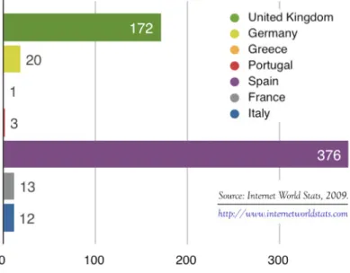
As a component of CAP, the labels are intended to encourage agricultural diversity, increase producer revenues, and ensure product quality for consumers (European Commission, 2009.; European Agricultural Fund for Rural Development, 2005.; European Commission, 2008). The labels are much more prevalent in the Mediterranean member states. Spain has 138 PDO and PGI labels - within the EU only France and Italy have more, see Figure 1.1. This geographic inclination towards the use of quality labels can be attributed to the a cultural emphasis placed on terroir and artisan production. The French term terroir articulates the idea that both the environmental characteristics of a region - its climate, soil and terrain - as well that the and cultural context of production - traditional processing and recipes - imbue products with unique characteristics (Parrott, 2002).
Figure 1.1 Percentage of total European Union PDO and PDI products from each member state.
Unfortunately, appreciation of regional quality does not always dictate the behavior of Spanish consumers. In a 2003 study performed by the Spanish consumer association (OCU), researchers found that geographic origin is only considered important during product purchase by 18% of shoppers (Villelas, 2005). In fact, the majority of Spaniards are not even aware of quality and origin labeling schemes (Giraurd, 2006). While the attitude of these shoppers is towards the idea of PDO and PGI products is favorable (Libery, 1998; Giraurd, 2006) they are not always willing to pay higher prices for such products (McCluskey, 2003). Consequently, the added income earned by farmers who participate in quality certification amounts to a modest €635 a year. In contrast, organic farming, though adopted only by a small number of Spanish farmers2, generates an average of €5,624 increased
yearly income per farm (Dominguez, 2006).
Efforts must therefore be undertaken to disseminate information about PDO and PGI products such as that will ultimately justify higher prices for shoppers. This type of information must highlight the extrinsic attributes of PDO and PGI products - craft, origin, and brand - as well as experiential
1 The European Union has recently implemented a third certification, Traditional Specialty Guaranteed (TSG). The label has yet to be broadly implemented, and Spain only has 3 TSG products registered. This project will handle the PDO and PGI certification schemes which are considerably more established and examined in the literature.
characteristics such as taste, appearance, and aroma (Hervieu, 2007; Briz, 2007). Experts suggest focused communication strategies targeted toward niche markets, and recommend a marketing emphasis on the specific regions and processes of production (Dominguez, 2006; Briz, 2007; van Ittersum, 2007; Villelas, 2005). The publication of time-honored regional recipes, a theme that has been receiving revived attention in recent years, also appears to be a promising approach to quality label marketing (Briz, 2007).
Spanish regulatory boards, in addition to enforcing quality controls, are responsible for product promotion. While the future importance of this duty is seen as extremely important by these institutional actors3, PDOs and PGIs do not currently possess the funding necessary to undertake
large scale marketing such as television advertisement or point-of-sale marketing (Sanz Cañada, 2005). Moreover, there are sizable challenges apparent in the institutional themselves: There is a lack of cooperation between regulators and other invested parties including private enterprises, non-governmental organizations, and university researchers. Additionally, while the percentage of internet users in the Spanish population is higher than the EU average and growing substantially faster than that of any other country (see Figure 1.2), little has been done to utilize this medium for product promotion. One explanation for this lack of innovation in this area is that regulators lack highly qualified human resources, especially in the area of new information technologies (Briz, 2007).
Figure 1.2 Increase in the number of internet users in seven EU member states between 2000 and 2008.
1.2 Objective: a geoCMS for promotion of quality labels
Farm2.0 serves as a prototype web portal that promotes PDO and PGI products in the Spanish community of Valencia. Designed according to the suggested marketing approaches discussed above, the fundamental goals of the system are to:
• Provide online information about the meaning of PDO and PGI labels.
• Educate consumers about the natural and cultural contexts of production for each product. • Allow users to locate retailers where products may be purchased.
In fact, most regulators already have portions of this information on existing websites. Unfortunately, reflecting the atomized PDO and PGI supply network itself, these sites are generally difficult to find and provide no form of unified navigation. Farm2.0 aims to serve as a hub for all Valencian product
promotion, and would provide links to existing sites and other resources. A single go-to resource for Valencian consumers would capitalize on the diversity of regional products and help to build up a broader brand recognition for the area as a whole. Furthermore, a survey of existing Valencian PDO and PGI sites revealed that none of them currently use any maps beyond a simple static map of their offices. Yet the very definition of PDO and PGI quality labels is geographic, and a dynamic web map would allow users to find vendors, browse recipes geographically, and explore the areas in which the products originate.
In recognition of the institutional challenges (small budgets, lack of coordination, and a dearth of skilled employees), as well as the potential of Web 2.0 innovations (user-created content, dynamic web design, and format standards for content aggregation and publication), the following technical goals
are proposed:
• Implement the system with free and open source software.
• Support management of content by by employees with minimal technical skills in multiple, dispersed organizations.
• Make the platform extensible so that other Spanish regions could use it out-of-the-box with a small number of customizations.
• Enable users to create site content: information about PDO and PGI vendors and producers as well as traditional recipes with PDO and PGI ingredients.
• Integrate user-friendly geographic referencing of user-generated content. • Visualize content in a map interface.
• Utilize existing online content and make Farm2.0 content available in standard formats for reuse.
These objectives are met by developing a geoCMS to facilitate the collection, management , and publication of spatially referenced content. The Farm2.0 system incorporates a user-friendly back-end interface for multiple administrators to manage a publicly visible site. This portal, alimentaValencia, allows registered users to contribute content in the form of geotagged PDO and PGI vendor or producer locations and regional recipes.
1.4 Methodology: tools and system design
A number of web content management systems (WCMS) and web mapping technologies were investigated for potential use in this project and are detailed further in Chapter 2. Ultimately, the following tools were chosen to provide optimal performance, high usability, and appealing interface design.
Software & platforms
Development of the Farm2.0 web map utilizes a combination of free, publicly available technologies to support the map interface and user-generated content, though commercial software application was used for graphic design.
• Apache4 free of cost, open-source, standards-compliant HTTP web server.
• MySQL5 free of cost, GNU General Public License relational database management system (RDMS).
• PHPMyAdmin6 free of cost, open-source MySQL administrator • Adobe Photoshop commercial graphics editor
• Mozilla Firefox with Firebug7 extension free of cost, open-source browser and extension for editing and debugging during web development; used for Javascript and CSS
• Wordpress8 free of cost, open-source publishing platform; used with a customized theme and plugin suite described in Chapter 3
Programming languages, APIs, and markup languages
• Google Maps API9 free of cost javascript library; must comply with terms of service • PHP 5.210 imperative, object-oriented server-side scripting language originally built and
especially suited for dynamic web pages
• Javascript11an imperative, prototype-based scripting language for client-side web development
• Cascading Style Sheets12 (CSS) a stylesheet language used to specify formatting and graphic styles displayed in a markup language for web documents
• GeoRSS13 a schema to encode geographic objects into really simple syndication (RSS) feeds
1.5 Thesis outline
Topics covered in this thesis are outlined below.
Chapter 2 Background: the Web 2.0 and geocontent
This chapter begins with the proposal that geocontent is distinct from the traditional concept of geographic data. Geocontent formats, along with methods of collecting and publishing geocontent, are discussed.
Chapter 3 GeoCMS: managing geocontent
Geocontent management is described in within the established Web Content Management System (WCMS) framework. Existing platforms for managing geocontent are reviewed.
Chapter 4 Farm2.0 functional design
An overview of the Wordpress platform and its ‘out-of-the-box’ functionality is provided. This is followed by a detailed explanation of the the plugins and modifications used to meet requirements specifications of the Farm2.0 system. The chapter ends with a description of geocontent handling . Chapter 5 Farm2.0 information architecture & graphic design
An overview is given of the Farm2.0 site structure, controlled vocabulary, and navigation tools. Graphic design requirements are discussed before explaining how a customized theme and icon set were implemented.
Chapter 6 Implementation and extensibility
Details are provided to describe the technical and administrative and steps that would be necessary to implement Farm2.0 platform. Further options for usage of the platform to manage additional geocontent are also suggested.
Chapter 7 Conclusion
A review of the system objectives is performed and possibilities for future work are proposed.
7 http://getfirebug.com/. 8 http://wordpress.org/.
9 http://code.google.com/apis/maps/. Terms of service: http://code.google.com/apis/maps/terms.html 10 http://es.php.net/.
11 http://www.w3schools.com/jsref/default.asp. 12 http://www.w3.org/Style/CSS/.
2 Background: the Web 2.0 and geocontent
The Web2.0 is characterized by the use of the internet as a platform for software and services that deliver continually-updated, user-generated technologies and information. By harnessing this collective intelligence with participatory architectures such as public application programming interfaces (APIs), social networking software, collaborative content classification, wikis, and blogs, the Web 2.0 establishes ‘architectures of participation’ that improve as they are used (O'Reilly, 2005). These technologies, coupled with new location-aware consumer electronics, have provoked a fundamental paradigm shift in the discipline of geography (Crampton, 2008; Goodchild, 2007; McConchie, 2008; Turner, 2006). The increasing ubiquity of user-generated geospatial data and mash-up maps put together with open APIs have blurred the traditional roles of mapmaker and map reader. Meanwhile, strident advances in web programming enable dynamic sites with interactive multimedia maps, which have superseded paper maps as the predominant cartographic end-product.
Such transformations have not gone unnoticed by academics. Technical aspects of web mapping, or
cybercartography (Fraser Taylor, 2003; Monmonier, 2005) is an active research topic. Data structures and processing are handled from a geoinformatic perspective (Badard, 2001; Jones, 2002) while specialists in Human Computer Interaction (HCI) evaluate the usability of web map interfaces (Nivala, 2007; Richmond, 2005; Koua, 2006). Further work has focused on the potential of online geovisualization for collaboration (Brodlie, 2005), knowledge discovery (Peuquet, 2002; Cartwright, 2004), and as components of a GIS (Kraak, 2004).
Citing their capacity to integrate distributed data sources, utilize multimedia, and involve a diversity of users in map creation, some have gone so far as to hail mash-ups as the future of Geographic Information Systems, a so called GIS/2 (Miller, 2006). Applications that use online maps to facilitate Public Participation GIS (PPGIS) and Volunteered Geoinformation (VGI) (Goodchild, 2007; Haklay, 2006; Kingston, 2000; Sieber, 2003; Tulloch, 2002), have prompted other geographers to examine social issues such as credibility (Bishr, 2007) and power structures (Crampton, 2001).
Neogeography has been widely adopted as a term to describes work done “outside the realm of traditional GIS...people creating their own maps, on their own terms...by combining elements of an existing toolset (Turner, 2006).” There are fundamental (and often controversial1) differences between
neogeography and the established discipline of GIS. Among them, geographic information itself has evolved to include a range of spatially referenced media, and it is this phenomenon that is the focus of this chapter.
2.1 A definition of geocontent
Geocontent, as referred to in this project, is distinct from the established concept of geographic data. Generally, geographic data refers to vector and raster files that spatiotemporally reference attribute values. Demographic, political, and environmental geographic data have become essential information sources in areas as diverse as consumer behavior, landscape ecology, and urban planning
(Longley, 2005). This data has historically been analyzed by professionals using desktop GISs, though recent web technologies have revolutionized the field2.
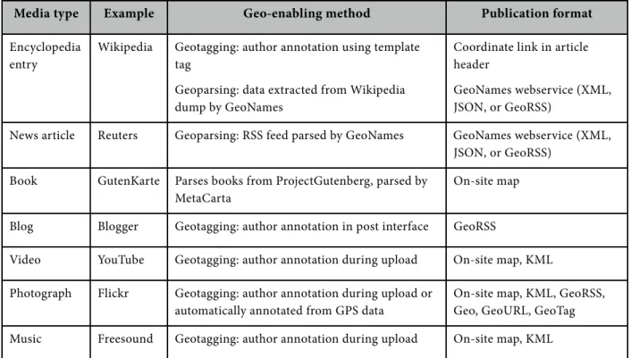
Geocontent, in contrast, refers to web content that has been spatially referenced. This content may be text, such as encyclopedia articles, news stories, books, or blogs. It could also be multimedia material such as videos, photographs, or music, see Figure 2.1. Geocontent thus includes geographic data, but in it’s most simplified form: Latitude and longitude coordinates are added to the preexisting content as metadata tags.
Media type Example Geo-enabling method Publication format
Encyclopedia entry
Wikipedia Geotagging: author annotation using template tag
Geoparsing: data extracted from Wikipedia dump by GeoNames
Coordinate link in article header
GeoNames webservice (XML, JSON, or GeoRSS)
News article Reuters Geoparsing: RSS feed parsed by GeoNames GeoNames webservice (XML, JSON, or GeoRSS)
Book GutenKarte Parses books from ProjectGutenberg, parsed by MetaCarta
On-site map
Blog Blogger Geotagging: author annotation in post interface GeoRSS
Video YouTube Geotagging: author annotation during upload On-site map, KML
Photograph Flickr Geotagging: author annotation during upload or automatically annotated from GPS data
On-site map, KML, GeoRSS, Geo, GeoURL, GeoTag
Music Freesound Geotagging: author annotation during upload On-site map, KML
Figure 2.1 Examples of geocontent available on the internet.
At the time of this writing, there are 611,745 geotagged Wikipedia articles in the GeoNames database (GeoNames.org, 2009.), and over 2.7 million photographs have been geotagged on Flickr in this month alone (Yahoo!, 2009). Considering the rapidly growing market for location aware electronics including mobile phones, GPS navigation devices, and GPS-enabled digital cameras (Global Information, Inc. , 2008), the demand for tools to easily incorporate geographic data into online content will only increase.
2.2 Geolocation formats
There are several formats utilized to encode geographic location into metadata for multimedia content. GML
In 1999, the Open Geospatial Consortium approved Geographic Markup Language3 (GML) as a
standardized XML grammar for encoding geographic information (Stefanakis, 2008). Although there are restricted GML profiles available for simplified use, the full model includes specifications for
2 Non-experts now widely participate in generating online maps through initiatives such as OpenStreetMap
(www.openstreetmap.org/) and Google Map Maker (http://www.google.com/mapmaker). Platforms such as Geocommons (http:// www.geocommons.com/) and Up2Maps (http://www.up2maps.net) enable users to find geographic data online and produce sophisticated cartographic visualizations for analysis. In the institutional arena, universities and governments are developing robust Spatial Data Infrastructures (SDI) for the to connect various GIS to share and standardize geodata sources and processing tools online. The European initiative INSPIRE (http://inspire.jrc.ec.europa.eu) is an example.
features (physical geographic entities), geometry (the shape of region), a coordinate reference systems, time, coverages, and even map styling specifications. Despite having been adopted by the US Census Bureau and Great Britain’s Ordnance Survey, the format has not been embraced for widespread use by the mainstream IT sector (Singh, 2004), nor the general public (Maron, 2006).
HTML geographic tags
Another early standard, proposed in 2002 (Hansen, 2009.), was the GeoURL4 format. It uses latitude
and longitude coordinates contained within an HTML header: <meta name="ICBM" content="39.470239,-0.37680"> <meta name="DC.title" content="My Website">
A similar effort, GeoTag5 was introduced in 2007 and inserts an HTML tag in the following format:
<meta name="geo.position" content="39.470239,-0.37680">
A third HTML encoding, the Geo6 is a subset of tags for the hCard microformat (used for encoding
contact information for people and businesses): <div class="geo">
<abbr class="latitude" title="39.470239">N 37° 24.491</abbr> <abbr class="longitude" title="-0.37680">W 122° 08.313</abbr> </div>
KML
Though all of the aforementioned formats are in use today, there is still no universal standard for spatial encoding. That said, two XML-based geographic formats have become ubiquitous on the internet, Keyhole Markup Language (KML) and GeoRSS.
KML7 was developed for three dimensional geographic data in Earth Viewer, the virtual globe
software that was acquired by Google in 2004 and renamed Google Earth. In addition to specifying feature, geometry, and time elements, KML also encodes attributes such as BalloonStyle, specifically for visualization in Google Earth and thus can be seen as complementary to GML (Lake, 2008). The huge popularity of Google Earth has prompted widespread adaptation of the KML format (Stefanakis, 2008), and the OGC approved KML as an open standard in 2008.
GeoRSS
The W3C developed the first GeoRSS, somewhat inadvertently, in 2003 (Schutzberg, 2006). W3C Basic Geo, often called geo:lat/geo:lon, adds a ‘Point’ class containing latitude and longitude values to XML documents. The format, originally intended as a RDF encoding, has nonetheless been widely adopted to encode RSS feeds. Although this version of GeoRSS is now deprecated, its widespread implementation continues (Doyle, 2009). Flickr, for example, includes W3C Basic Geo, in addition to GeoRSS-Simple, in their ‘geofeed’ (Catt, 2007).
GeoRSS-Simple extends the number of classes available for encoding, allowing the feed to represent a greater range of geographic properties, such as lines, polygons, elevation. It also include tags for describing features and relationships between features. It is meant, however, to be concise (Doyle, 2009.), so its most basic (point) encoding is accomplished in a single line:
<georss:point> 39.470239,-0.37680 </georss:point>
4 http://geourl.org/.
5 http://geotags.com/geo/geotags2.html. 6 http://microformats.org/wiki/geo.
GeoRSS-GML sacrifices simplicity for upward-compatibility. It is a formal GML Application profile and allows for support of more features and alternate reference systems (GeoRSS-Simple is confined to WGS-84).
<georss:where> <gml:Point>
<gml:pos> 39.470239 -0.37680 </gml:pos> </gml:Point>
</georss:where>
Google Maps began supporting GeoRSS feeds in 2007 and in 2008, ESRI added the capability to view GeoRSS in ArcGIS Explorer (ArcGIS Explorer Team, 2008). Further support for GeoRSS feeds is also available from Mapufacture8, a user friendly web-mapping application that allows users to aggregate
GeoRSS feeds from multiple sources and view them on a customized map. Additionally, there are several services such as RSS2 Google Earth9 that can convert GeoRSS feeds into KML files for viewing
in Google Earth.
2.3 Content collection: geoparsing and geotagging
Since geocontent is generated by the spatial referencing of existing materials, it is not created per se. Consequently, geocontent collection involves acquiring a media item and then assigns coordinate values to it. Media may be obtained from a variety of sources including a really simple syndicate (RSS) feed, a collective multimedia repository such as Flickr or Youtube, or files from a personal computer. Once acquired, there are two ways to assign spatial coordinates to the content: geoparsing and geotagging.
Geoparsing
Geoparsing semantically analyzes textual data by identifying and ranking place names within the text (Scharl, 2007). The extracted location names are then sent submitted to a geocoding services which query gazetteers (place name indices) for retrieval of precise spatial coordinates including latitude, longitude, and altitude (Hill, 2002). One such geocoding service, GeoNames, compiles public domain geographic data including place names (toponyms) and postal codes. Their database, which contains over 6 million toponyms, is searchable and downloadable, free of charge, to the public. It is also accessible through various web services, including RSS & GeoRSS to KML10 which accepts RSS feeds and outputs keyhole markup language (KML) files for viewing
in a geobrowser such as Google Earth. Services, such as findNearbyWikipedia, utilize data that GeoNames retrieves periodically from Wikipedia dumps (GeoNames.org, 2009).
MetaCarta11, a commercial company, also provides geoparsing and geocoding services free of charge.
Gutenkarte12 downloads public domain texts from Project Gutenberg, and then feeds them to
MetaCarta's GeoParser API. Place names are extracted from the classic documents, matched with geographic coordinates, and visualized on an interactive map.
Because geoparsing is an automated technique, it can handle large quantities of data quite easily. It is not without its drawbacks, however. False positives can result from the extracting of a place name that belongs to multiple locations (e.g. Madrid, Spain and Madrid, New Mexico). A document may mention more than one place, or a place name may change over time. Measures are implemented to minimize errors, perhaps by considering language-dependent lexical cues or identifying the names of people to provide context for disambiguation. A set of rules can be
8 http://mapufacture.com/.
applied to prevent the assignation of a document to multiple places, or locate two documents with the same place names at nearby coordinates. Despite these sophisticated protocols, a small number of errors remains unavoidable (Scharl, 2007).
Geotagging
In general, geotagging must be done by users manually. Exceptions include data gathered by location-aware mobile devices and digital cameras, GPS navigation systems, and IP address geolocation. In all other cases, geotagging requires that a user specify the location of a given piece of content.
The HTML geographic tags described in 2.2 require users to obtain their latitude and longitude coordinates and modify their HTML files by hand. While these are relatively simple tasks and instructions are provided, the typical user with no web programming experience might not feel capable of implementing these tags.
Many multimedia sharing sites such as Flickr, Panoramio, YouTube, and Freesound also allow users to geotag media as they upload them. These interfaces, in contrast to the HTML geographic tags, are designed to be highly usable and offer automatic address geocoding, draggable map markers, and the ability to use both tools in combination to accurately plot their location.
Manual geotagging may allow more precision than geoparsing, but ambiguity is still an issue. Users, for instance, may accept the geocoded result of an address input without double checking to ensure that the intended location was chosen. A marker might appear to be correctly positioned at a low zoom level and submitted as a tag only to appear inaccurately positioned once it is displayed at a larger scale. Beyond this, a user may simply forget or misunderstand the source of a media acquisition.
Whether it is implemented through (manual) geotagging or geoparsing, the collection of geospatial content is ultimately dependent on a human reasoning. By placing a marker on a map or noting the name of a place in a text, the user assigns media an explicit metadata attribute to characterize their personal understanding of an implicit geographic characteristic. User-generated geographic data is thus dependent on qualitative spatial reasoning, and as the diversity of sources expands there will likely be increasing heterogeneity in the accuracy and precision of such data (Elwood, 2008).
The image in Figure 2.2 illustrates this phenomenon: The image represents about 1.2 million geotagged photos from Flickr, with each dot colored according to a (text) tag specifying the name of a state. It is striking that such distinct boundaries can be generated from these tags, but also important to notice that a handful of photos have been textually tagged with a state name that conflicts with the geotagged coordinate location.
2.4 Content publishing: mashup maps and syndication
In step with the rise of geocontent, the past few years have witnessed a veritable explosion of online mapping. Major media sources such as the New York Times now frequently provide interactive maps with user-generated content13 to accompany their articles, while mash-up maps have become
indispensable to users whether they’re searching for an apartment14, locating a recycling center15, or
keeping track of local events16. These examples demonstrate the enormous appeal of maps as a form of
13 For a recent example, see the NYTimes map of Twitter tweets in the US during the Super Bowl: http://www.nytimes.com/ interactive/2009/02/02/sports/20090202_superbowl_twitter.html.
14 Housingmaps.com, made in 2005 and often cited as the first map mash-up, plots housing classifieds from Craigslist.org as an overlay in Google Maps (RIA News , 2006.): http://housingmaps.com.
15 Open Green Map provides a collaborative map for worldwide users to locate, comment on, and annotate resources supporting environmental activism (Parker, 2006): http://greenmap.org/dev/ogm/en/greenmap.
Figure 2.2 Boundaries of the lower 48 US states as delineated by user-supplied tags on Flickr photos. The right image shows a close-up of the northeastern US. This visualization17 was created by Jim Bumgardner, is under
Creative Commons license, and has been used with his permission.
content browsing, which, some argue, is attributable to the fact that they are an inherently good form of communication: Maps serve as an intuitive and efficient browsing interface because they display information on the Earth itself, an accessible and recognizable metaphor for users (Scharl, 2007). Once coordinate values are attached to content, an information repository essentially becomes a set of spatial annotations. Flickr, Panoramio, Freesound, and YouTube all offer interactive maps of their geotagged content and also allow users to search for content by location. Offering another degree of complexity and sophistication, Google’s MyMaps18 application allows users to import and export both
KML and GeoRSS formats and add their own locations to create personalized maps. These are may be embedded into websites or viewed on top of Google’s extensive platform and thus enriched by services such as driving directions, public transportation information, and even Street View imagery in an ever-increasing number of cities.
UMapper19, meanwhile, gives users a choice of base maps including OpenStreetMaps, Microsoft
Virtual Earth, Yahoo Maps and Google Maps. Their rich Flash interface can import GeoRSS and KML feeds and provides a range of overlay options for creating lines, bounding boxes and circles with custom symbology. When completed, the map may be exported as ActionScript 3.0 or KML. Additionally, they offer analytics and wiki services so that users can open their maps up to collaborators and monitor viewing statistics.
Another project, worldKit20, streams a variety of content including RSS feeds and Web Map Services
(which can provide satellite imagery) onto a Shockwave Flash (SWF) web maps. It integrates several geocoding services, and functions as either a standalone map or as a component of a broader project. The platform has been used for range of applications, from neighborhood storytelling projects21 to an
interactive map of historic world population growth22.
17 Available on Flickr: http://www.flickr.com/photos/krazydad/2986774792/. 18 Requires registration: http://maps.google.com/maps?tab=ol.
19 http://www.umapper.com/. 20 http://worldkit.org/doc/.
Although available for US locations at the moment, Outside.in23 aggregates GeoRSS feeds so that
users can browse content based on their location. They also offer GeoToolkit which allows users to embed maps into their web content, analyze statistics on map usage by site visitors, and publish their content to the Outside.in aggregator.
Outside of online mapmaking software and proprietary APIs (such as that of Google), number of users and organizations have developed their own maps using Free and Open Source Software (FOSS). OpenLayers24, for example, is widely used to create dynamic web maps, and is capable of
integrating data in KML and GeoRSS formats in addition to more complex OGC geographic data formats such as Web Coverage Services (WCS) for georeferenced raster data, Web Feature Services (WFS) for GML formats, and Web Map Services (WMS), for georeferenced map images and legend information. Such formats are designed for distributing geographic data for use in GIS analysis and are key to creating Spatial Data Infrastructures (SDIs)2. In general, these specifications are overly
complex for geocontent, though several of the GeoCMS platforms discussed in Chapter 3 are capable of handling them.
3 GeoCMS: managing geocontent
Web 2.0 technologies and content publication methods require new paradigms of content management (Tramullas, 2005). Web content management systems (WCMS) are utilized by enterprises and institutions to facilitate the collection, management, and publication of online materials (Boiko, 2001). Traditionally these systems have offered simple scripting interfaces to enable the production of static HTML web pages that were then uploaded by a designated webmaster to a public web site via file transfer protocol(FTP) (Nakano, 2002). Visitor numbers and content volume have risen dramatically over the last decade, and it is also increasingly imperative to publish and aggregate content dynamically. As a result WCMS have evolved to incorporate sophisticated capabilities such as automatic versioning, intelligent error checking, and automatic updating. These new tools enable employees with minimal technical expertise to create and manage large quantities of content directly through a user-friendly back-end interface, while maintaining a clear, professional public site (McKeever, 2003).
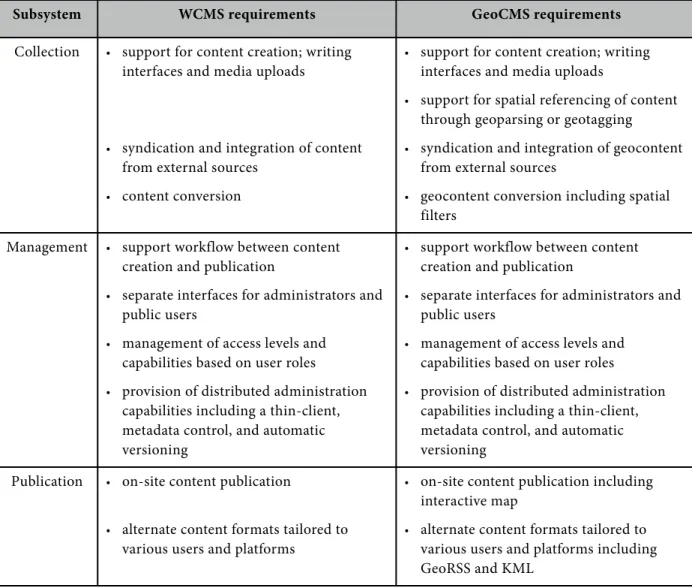
The introduction of spatially referenced materials, however, adds new dimensions (quite literally) to a WCMS framework. In Chapter 2, we described the standard formats used to store the geographic data in geocontent, prominently KML and GeoRSS. It was explained that existing methods of attaching this data, geoparsing and geotagging, while imperfect, are widely adapted and can be implemented fairly easily through a range of services. Finally is also a wide appeal to interactive web maps and many platforms to support geographic content visualization. The missing component, then is the overall system of content management, a specialized GeoCMS, to integrate these methods and technologies. An examination of the parallels between web content management and geocontent management allow us to define the expected functionality of a GeoCMS, see Figure 3.1.
3.1 Functions of a GeoCMS
In WCMS terminology, the collection subsystem is used to both create content and acquire it from various sources. It must include interfaces for administrators, and possibly users, to write and upload media. If outside content requires reformatting or filtering, it must also handle these conversion tasks (Boiko, 2001; Tramullas, 2005). A GeoCMS adds the requirements necessary to collect geocontent including support for spatial referencing of written content or included media. Conversion of external content may also include geographic filters.
The management subsystem is the most complex component of a WCMS, as it integrates all components into a single framework. It incorporates the creation activities with the steps necessary for publication to online audiences. Additionally, the management subsystem provides separate interfaces for administrators and public users, and manages capabilities and access levels based on these roles. Finally, it supports distributed administration through a browser interface, metadata control, and automatic versioning (McKeever, 2003). A GeoCMS should support all these functionalities.
Subsystem WCMS requirements GeoCMS requirements
Collection • support for content creation; writing interfaces and media uploads
• syndication and integration of content from external sources
• content conversion
• support for content creation; writing interfaces and media uploads
• support for spatial referencing of content through geoparsing or geotagging
• syndication and integration of geocontent from external sources
• geocontent conversion including spatial filters
Management • support workflow between content creation and publication
• separate interfaces for administrators and public users
• management of access levels and capabilities based on user roles
• provision of distributed administration capabilities including a thin-client, metadata control, and automatic versioning
• support workflow between content creation and publication
• separate interfaces for administrators and public users
• management of access levels and capabilities based on user roles
• provision of distributed administration capabilities including a thin-client, metadata control, and automatic versioning
Publication • on-site content publication
• alternate content formats tailored to various users and platforms
• on-site content publication including interactive map
• alternate content formats tailored to various users and platforms including GeoRSS and KML
Figure 3.1 A comparison of WCMS and GeoCMS requirements.
3.2 Existing geo-enabled WCMS frameworks
Several WCMS have begun to incorporate geocontent management. Interestingly, no previous academic publications discussing GeoCMS frameworks were found during this research, aside from a single article that acknowledges that Location Based Services rarely exploit such a platform (Raper, 2007). That said, there are several open-source platforms that have promising geospatial components. TikiWiki1, a PHP-based wiki platform, and PrimaGIS2, an application for the the Plone3 CMS, both
integrate the MapServer4 web mapping application and allow users to upload shapefiles and raster
imagery. TikiWiki has yet to implement location attributes for blog entries, photos and other media (Martin, 2007). PrimaGIS is capable of geotagging media files using their iGeoAware interface. Both lack functionality for importing KML or GeoRSS. In both cases, dates on the documentation pages and broken links to example maps might indicate that the development of geo-enabling extensions has stalled, and no implementations were found for inspection. There are several other similar
1 http://info.tikiwiki.org/tiki-index.php. 2 http://www.primagis.fi/.
examples of WCMS platforms with apparent geocontent functionality, but poor documentation and few visible implementations. The remainder of this chapter will focus on four WCMS that have been recognized for their potential to handle geographic content, see Figure 3.2.
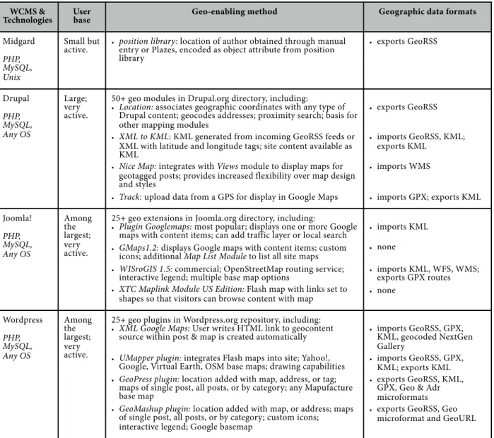
Midgard
The open-source CMS Midgard5, was one of the first CMS to add a substantial toolset for aggregating
and creating GeoRSS feeds in 2006 (Turner, 2006). This is done through a position library6 that
encodes locations for Midgard objects (articles, topics, etc.) according to the location of the author. Location information is obtained through manual entry, Plazes7 data, or even through Flickr photo
feeds. Once appended to content, the location data is published as GeoRSS tags in site feeds. Drupal
Drupal8, a widely used open-source CMS, has several modules that implement GeoCMS capabilities.
These include Nice Map, a WMS client; KML Parser, for aggregating KML contents; and Location, which enables site content to be syndicated in GeoRSS. Recently, functionality has even been added that even allows users to aggregate KML and GeoRSS feeds into an RDF data store9. The platform has
the advantage of having a highly active community of contributing users, and one can expect that their geographic extensions will continue develop at a fast pace. In general, the geo-enabling modules in Drupal focus on transformation between formats and associating content with locations rather than producing plug-in maps. Though Drupal is notoriously complex to configure (Daniūnas, 2008; Reilly, 2006), proponents of the system argue that the learning curve is significantly flattened with each version. Nonetheless, the remaining stigma may discourage adoption of Drupal as a GeoCMS for organizations and enterprises that lack skilled technicians.
Joomla!
Joomla!10 is another popular open-source CMS. Like Drupal, it has an extremely active user base that
consistently contribute new extensions for the platform. Among these there are a variety of options to support GeoCMS functions. Google Maps Multipage11, for example, enables users to load marker data
from an XML file or GeoRSS feed and display them as markers in Google Maps or Google Earth. KML export is also available. WisRoGIS12 is a particularly advanced extension that handles WMS and
WFS layers in addition to GeoRSS and KML and also provides routing services based on OpenStreetMap’s Routing Service. WisRoGIS, however, is a commercial extension that costs €53. In contrast to the Drupal modules which are almost exclusively free of cost (drupal.org, 2008.), a handful of Joomla!’s most powerful extensions are commercial.
Wordpress
Although frequently considered a specialized weblog platform, Wordpress13 has been popularly
implemented as a WCMS for several years (Bernier, 2006). It is regarded as having an extremely user-friendly interface and strong content classification functions (Tramullas, 2006), which has made it a practical content management platform for institutions such as libraries (Dodson, 2008.; Mitchell, 2008; Xiao, 2008), schools (Couros, 2006; Archambault, 2008), and science laboratories (Ikeno). High-profile implementors of Wordpress as a CMS include the United States Postal Service and the Ford Auto Show (Frangos, 2008). Functionalities that enable content management in Wordpress are
5 http://www.midgard-project.org/.
6 Description: http://bergie.iki.fi/blog/the-midgard-position/. 7 http://plazes.com/.
8 http://drupal.org/.
9 Description of this feature: http://www.developmentseed.org/blog/2008/dec/06/talking-about-places-you-dont-have. 10 http://www.joomla.org/.
offered by plug-ins (discussed in Chapter 4). Similarly, a wide range of plugins are available to handle geocontent, see Figure 3.2. In contrast to Drupal modules that are used in combination to achieve customized location solutions, Wordpress plugins tend to be targeted toward an audience with less web-development expertise who desire simple one-plugin map implementations.
Numerous comparisons of WCMS platforms are available on the internet, yet the high speed of development in this field renders them obsolete fairly quickly. The CMS Matrix14 offers one the most
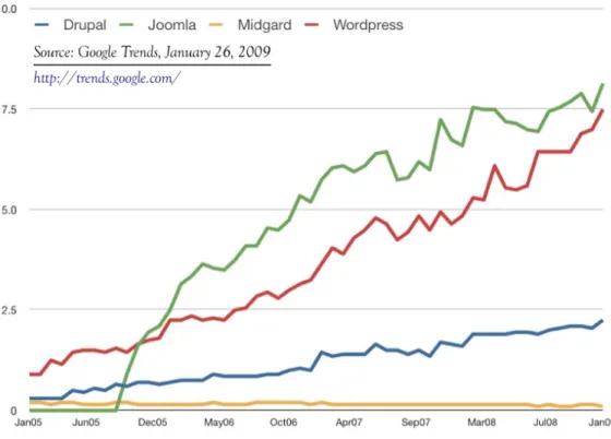
inclusive and up-to-date comparisons of capabilities and technologies. Because WCMS frameworks can often be downloaded from multiple sites and more than one time by a single user, it is difficult to quantify the number of installations of each framework that currently in use at any given time. In the absence of such data, a comparison of Google searches for the name of four GeoCMS frameworks is shown in Figure 3.3. This at least gives an impression of relative online interest in the various platforms.
14 http://www.cmsmatrix.org/. WCMS &
Technologies User base Geo-enabling method Geographic data formats
Midgard PHP, MySQL, Unix Small but active.
• position library: location of author obtained through manual entry or Plazes, encoded as object attribute from position library
• exports GeoRSS
Drupal PHP, MySQL, Any OS Large; very active.
50+ geo modules in Drupal.org directory, including:
• Location: associates geographic coordinates with any type of Drupal content; geocodes addresses; proximity search; basis for other mapping modules
• XML to KML: KML generated from incoming GeoRSS feeds or XML with latitude and longitude tags; site content available as KML
• Nice Map: integrates with Views module to display maps for geotagged posts; provides increased flexibility over map design and styles
• Track: upload data from a GPS for display in Google Maps
• exports GeoRSS
• imports GeoRSS, KML; exports KML
• imports WMS
• imports GPX; exports KML
Joomla! PHP, MySQL, Any OS Among the largest; very active.
25+ geo extensions in Joomla.org directory, including:
• Plugin Googlemaps: most popular; displays one or more Google maps with content items; can add traffic layer or local search • GMaps1.2: displays Google maps with content items; custom
icons; additional Map List Module to list all site maps • WISroGIS 1.5: commercial; OpenStreetMap routing service;
interactive legend; multiple base map options
• XTC Maplink Module US Edition: Flash map with links set to shapes so that visitors can browse content with map
• imports KML
• none
• imports KML, WFS, WMS; exports GPX routes • none Wordpress PHP, MySQL, Any OS Among the largest; very active.
25+ geo plugins in Wordpress.org repository, including: • XML Google Maps: User writes HTML link to geocontent
source within post & map is created automatically
• UMapper plugin: integrates Flash maps into site; Yahoo!, Google, Virtual Earth, OSM base maps; drawing capabilities • GeoPress plugin: location added with map, address, or tag;
maps of single post, all posts, or by category; any Mapufacture base map
• GeoMashup plugin: location added with map, or address; maps of single post, all posts, or by category; custom icons; interactive legend; Google basemap
• imports GeoRSS, GPX, KML, geocoded NextGen Gallery
• imports GeoRSS, GPX, KML; exports KML • exports GeoRSS, KML,
GPX, Geo & Adr microformats • exports GeoRSS, Geo
microformat and GeoURL
Figure 3.3 Google search volume index of Drupal, Joomla, Midgard, and Wordpress. Scale is based on the average worldwide traffic of Joomla in all years.
4 Farm2.0 functional design
Having chosen Wordpress as our WCMS platform, we will first give an overview of its basic system structure. This is followed by a review of the Farm2.0 system requirements and a description of the customizations that are necessary to implement those functionalities.
4.1 The Wordpress platform
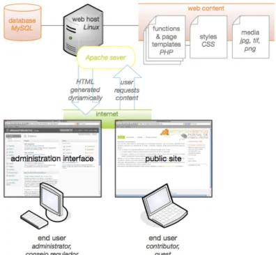
Wordpress is self-hosted publication software, so it is installed on a server and edited online. PHP templates retrieve content from the database as they are requested from the client browser, and the HTML that appears onscreen is generated dynamically. This is known as dynamic publishing. Some publishing platforms such as Blogger and MovableType, use static publishing methods which create new HTML files as content is published or comments are made. Static publishing platforms have the advantage of loading faster, and they do not require the content to be hosted on the user’s web server. However, since HTML elements such as headers and sidebars are duplicated on every page, static publishing requires much more space. Dynamic publishing, however, allows changes to content or styles, in addition to comments from users, appear instantly online. For these reasons, sites with dynamic content and actively contributing visitors are often best served by a dynamic platform (Douglass, 2005). An overview of the basic Wordpress structure utilized in Farm2.0 is shown in Figure 4.1.
Figure 4.1 Wordpress is a self-hosted dynamic publishing platform.
The Wordpress platform is customizable through plugins, which add specific functionalities, and
themes which control the way the content is displayed. There are a number of plugins and themes that are regularly used to implement WCMS capabilities. Farm2.0 theme and style choices will be discussed in Chapter 5, while the remainder of this chapter will cover the use and customization of plugins to meet system requirements.
4.2 Requirements analysis and implementation
the GeoCMS functional requirements defined in Section 3.1. A list of all plugins used, with links to documentation and downloads, is available in Appendix A2.
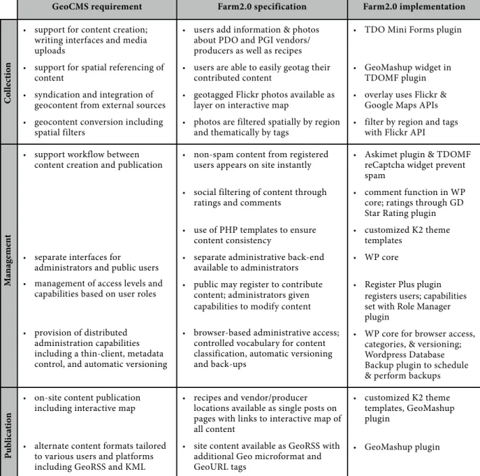
GeoCMS requirement Farm2.0 specification Farm2.0 implementation
• support for content creation; writing interfaces and media uploads
• support for spatial referencing of content
• syndication and integration of geocontent from external sources
• geocontent conversion including spatial filters
• users add information & photos about PDO and PGI vendors/ producers as well as recipes
• users are able to easily geotag their contributed content
• geotagged Flickr photos available as layer on interactive map
• photos are filtered spatially by region and thematically by tags
• TDO Mini Forms plugin
• GeoMashup widget in TDOMF plugin
• overlay uses Flickr & Google Maps APIs
• filter by region and tags with Flickr API
• support workflow between content creation and publication
• separate interfaces for
administrators and public users
• management of access levels and capabilities based on user roles
• provision of distributed administration capabilities including a thin-client, metadata control, and automatic versioning
• non-spam content from registered users appears on site instantly
• social filtering of content through ratings and comments
• use of PHP templates to ensure content consistency
• separate administrative back-end available to administrators
• public may register to contribute content; administrators given capabilities to modify content
• browser-based administrative access; controlled vocabulary for content classification, automatic versioning and back-ups
• Askimet plugin & TDOMF reCaptcha widget prevent spam
• comment function in WP core; ratings through GD Star Rating plugin
• customized K2 theme templates
• WP core
• Register Plus plugin registers users; capabilities set with Role Manager plugin
• WP core for browser access, categories, & versioning; Wordpress Database Backup plugin to schedule & perform backups
• on-site content publication including interactive map
• alternate content formats tailored to various users and platforms including GeoRSS and KML
• recipes and vendor/producer locations available as single posts on pages with links to interactive map of all content
• site content available as GeoRSS with additional Geo microformat and GeoURL tags
• customized K2 theme templates, GeoMashup plugin
• GeoMashup plugin
Figure 4.2 Overview of Farm2.0 requirement specifications and plugins used to meet them.
Content creation
In Wordpress, there are two main content types, pages and posts. Pages are meant for more permanent content that users need to appear styled in a certain way through specific page templates. Posts, in contrast, are used for new content, and are organized into categories so that their display can be managed collectively (Douglass, 2005).In Farm2.0, pages include the Inicio (start) page, indexes of recipes and posts, and the interactive map. Each product has its own page as well, and the regulatory board for that product is capable of modifying the content on that page through the administration panel. Discussion of the page content type is revisited in Chapter 5.
In Farm2.0, users cannot create pages. Instead, public users add content in the form of posts. This content may be a recipe, a PDO/PGI producer, or a PDO/PGI vendor. Users should be able to
spatially reference their content and attach additional media, in the form of uploaded photos. Whereas in the standard Wordpress platform content creation is performed from the administrative back end, public users should not have access to this interface and therefore cannot create posts. We have modified this with a plugin, TDO Mini Forms that builds a form to turn user-generated content gathered from a form into a post. The plugin comes with a set of widgets that allow the creation of custom fields, such as “phone number” so that content elements can be retrieved individually from the database. There is a widget that displays the GeoMashup plugin interface so that content can be spatially referenced within the form. Users to search for a location by name, drag a marker on an interactive map, or perform a combination of both actions to set a location for their content. The interface for post submission is shown in Appendix A1.
Content creation also includes the syndication, and conversion if necessary, of outside data. In the case of Farm2.0, geotagged photos from Flickr should appear as optional map layers. The overlay itself is handled by customizing the javascript in the GeoMashup plugin by adding a GGeoXML object with the addOverlay function from the Google Maps API. In this case, the XML object being imported is a Flickr feed of geotagged photos in Valencia. The purpose of including these photos on the map is to give users a feel for the natural and cultural context of PDO/PGI food products, it is necessary to filter out photos that are irrelevant and inappropriate. This is done by adding tags to the feed parameters so that included photos are not only filtered spatially, but thematically as well. Two Flickr overlays are available in the map, one for photos tagged naturaleza, cosecha, granja (nature, harvest, farm) and another for photos tagged comida (food). The resulting overlays are dynamic, so they will include different photos as the Flickr repository grows. Examples of the overlay are shown in Figure 4.3.
Figure 4.3 Overlay of Flickr photos tagged with naturaleza, cosecha or granja.
Content management
Comment spam, content posted in web sites to promote a user’s own site, is a continual problem that plagues websites where users have the capability to add comments or content (Douglass, 2005). Wordpress supports comment moderation, but this problem is complicated for the Farm2.0 system by the aforementioned modifications to allow users to publish posts. In order to combat spam, two plugins are used. Askimet runs submitted content through a hundreds of filters to determine whether content is spam, and is available as a Wordpress plugin. The TDOMF plugin allows form submissions to be run through the Askimet service before publication. Additionally, TDOMF includes a reCaptcha widget. ReCaptcha takes phrases from scanned manuscripts that computers cannot read through Optical Character Recognition (OCR).1 In TDOMF, content will not be accepted unless the user
correctly types the letters, ensuring that they are not mechanized spam posters (often called spambots).
Another element of managing content could also be considered a type of content creation; the use of social filtering through user-generated ratings and comments. Wordpress includes commenting capability by default, while users are given the ability to rate posts through the GD Star Rating plugin. These functionalities allow site visitors to evaluate post content based on existing ratings and comments or add their own.
The Register Plus plugin is used by Farm2.0 to extend Wordpress registration handling. Register Plus utilizes the site logo on the registration and login screens to maintain graphic consistency. (Normally the Wordpress logo appears on these screens.) It also allows custom emails to be sent to users upon registration, utilizes the previously mentioned reCaptcha widget, and redirects public users to the page they were previously on once they log in. (Without the plugin, users are taken to the administration panel.)
Wordpress has a built in role management, but Farm2.0 requirement specifying administrator-only access to the administration panel complicates with this default functionality. To define user levels and capabilities, the Role Manager plugin was installed. This allows public users to contribute posts through TDOMF while restricting their access to the back-end interface. For a complete listing of roles and capabilities, refer to A3 in the Appendix. Roles are implemented for one or more
Administrators, who have full capabilities including Wordpress update, plugin installation, page creation, and role management. The Consejo Regulador (Regulatory Council) role, given to each of the individual regulatory councils of every PDO/PGI product, allows modification of one product page as well as the ability to moderate comments. Once a user registers, they are automatically given the role
Colaborador (Collaborator), and can contribute posts and comments once they log in with the password emailed to them by Register Plus. Posts will not appear until they have been approved by a Consejo Regulador or the Administrator. Wordpress also integrates the use of gravatar, globally recognized avatars, which are photos or icons attached to a user’s email address. Increasingly popular, any user can choose their avatar by registering at Gravatar.com2. Their chosen image will then show
up automatically next to their comments on any of the numerous websites that use the system. In Farm2.0, this comments, ratings, and gravatars help to lend a social-networking aspect to the system and foster a feeling of community.
The Wordpress platform, as discussed in the introduction to this chapter, already implements a separate, browser-based administrative interface, see Appendix A5. Versioning is also done automatically, so previous content on pages can be restored if needed. The WP Database Backup plugin provides regularly scheduled database backups. Backups may be saved to the server, downloaded, or emailed to a specified address.
Category management is also available in the Wordpress platform by default. In Farm2.0, the Administrator role has all category management capabilities. TDOMF automatically categorizes recipes as recetas and stores, producers, or informal sale points as comerciantes. Users can then choose the products under which their post will be categorized, and have the option of choosing multiple products for a single post. More information on categories is available in Chapter 5.
Content Publication
As a content publication platform, Wordpress handles most aspects of content publication with PHP templates that retrieve data dynamically from the database, as described in Section 4.1. In addition to the templates included in the K2 theme, several custom page templates were created. Creation of the customized styles and graphics is discussed in Chapter 5.
Map publication is handled through the GeoMashup plugin, which automatically implements the core GeoCMS functions in Farm2.0. The latitude and longitude data obtained by the GeoMashup widget is stored for each post. A PHP template tag is added to the template for single posts to display a small map on each page to display the origin or location of a recipe, farm, or vendor. There is also a link on each post to view the location on the global map containing all posts. The GeoMashup version implemented in Farm2.0 is actually a beta that is to be released soon for download. In this version, the legend is interactive, so various categories of icons can be turned on and off. If the global map is linked to from a product page, it only shows locations that are in that product category and a button appears that allows viewers to switch on all posts. Further details on the cartographic choices and functions in the map are detailed in Chapter 5.
GeoMashup also automates publication of Farm2.0 geocontent using several of the geocontent standard formats. GeoRSS Simple tags are added to the site’s RSS feed, while Geo microformat and GeoURL tags are also encoded in individual post pages.
4.3 Geocontent flow
The flow of geocontent in the Farm2.0 system begins with a user geotagging their content through the GeoMashup widget in TDO Mini Forms. Geotagging is accomplished by utilizing the Google Maps API either though their geocoding service (for address entry), or a map listener that records coordinates upon a click event. The user may re-search or move the marker. The latitude and longitude of the marker at the time the post is saved is stored in a GeoMashup-created table in the Wordpress database. When the post is displayed, a PHP template tag retrieves the coordinates from the database and displays them on a small Google Map with a generic marker. Below the map, a link to the global map is displayed. When clicked, the user is taken to the global map which is centered on the post from which they came.
If the user goes to the global map through the top menu on the site, all posts are displayed on the map and the view is centered on the most recent post. Turning on and off categories in the interactive legend toggles the display of posts in that category through dynamic queries to the GeoMashup database. Clicking on a marker in the global map reveals an excerpt of the post and a hyperlink to the single page. When the user is viewing the page for a specific PDO/PGI product, a link in the sidebar takes them to the global map with only locations in that product category toggled. Any time when the global map is rendered without all posts displayed, a button to display all posts appears.
The Flickr API services are used to aggregate geotagged photos for display on the map, These are filtered by theme and region, as previously discussed.
Figure 4.4 Geodata flow in the Farm2.0 system.
5 Farm2.0 information architecture & graphic design
The technical structure of the Farm2.0 system as discussed in the previous chapter cannot stand alone. To the contrary, the functionalities supported by the system must be substantiated by a usable, intuitive information architecture. Additionally, the graphic design of the site must support site usability and create visual appeal. In this chapter, an overview is given of the Farm2.0 site blueprint, controlled vocabulary, and navigation tools. Graphic design requirements are discussed before explaining how a customized theme and icon set were implemented.
5.1 Information architecture
Information architecture involves the organization and labeling of websites to support findability and usability (IAI, 2008). The process begins with the logical definition of granularity and relationships between site components. In the case of Wordpress, the out-of-the-box architecture was originally designed primarily for use of the platform as a weblog, and posts, essentially blog entries, were the only built-in content type. By default, posts are displayed in reverse chronological order as the central content, with other information, such as hyperlinks or a search box, visible in sidebars, headers or footers. However, a number of PHP template tags allow users to sort and display posts, links to posts, or post excerpts in these areas with great flexibility. For example, users frequently have links to their most popular or recent entries shown in a sidebar.
As an increasing number of users have begun to use the software as a WCMS, however, the system has evolved to handle an additional content type: Since the release of Wordpress 1.5 in 2005, users can also create “static” pages. Though they are still generated dynamically by templates, pages are static in the sense that they exist apart from the usual category/date hierarchy (Lynch, 2005). Pages can be given permanent locations in the site and maintain a separate hierarchy through the use of subpages
that are assigned to parent pages.
Farm2.0 makes extensive use of pages to organize content. The top menu displays the four parent pages, inicio (start), productos (products), recetas (recipes), and Dónde comprar (where to buy). The start page has a short description of the alimentaValencia1 site including an explanation of the PDO and PGI quality labels and a contact link to email the site administrator. The sidebar that is visible on all pages except the map has links to the site’s GeoRSS feed, a list of the five most recent contributions to the site, the login page (unregistered users see registration information on this page instead), and site search. The search results page displays a list of posts (vendors or recipes) that contain the search terms.
The product parent page has a list of the PDO/PGI products from Valencia.2 The product names are
links to subpages for each product. These product subpages contain photos and descriptions of the products along with hyperlinks to the product regulators’ external sites. They also contain dynamic sidebar links to a list of contributed recipes and the interactive map. These links are dynamic in that they attach a PHP parameter to the URL that instructs the search results page template or map page template to display only recipes or map markers in that product’s particular category (details in Section 5.2).
The recipes page contains a link to the form users can use to add a recipe, a link to browse recipes in the map, an interface for browsing recipes by category (see Section 5.2), and an alphabetical list of all recipe posts. Similarly, the where to buy page contains a link to the form for users to add a vendor, a
1 Farm2.0 is meant to be extendible, and every implementation of the system should have a name that reflects the location and language of the region that it promotes. The name alimentaValencia comes from the Spanish word alimentar, which is a verb meaning to feed (a person or animal), to nurture or cherish (a belief), and to boost (an ego or motor).