INSIGHTS OF MESO AND MICRO-SCALE PROCESSES FOR THE CAXIUANÃ FOREST
REGION FROM HIGH RESOLUTION SIMULATION
RENATA LEITÃO DA CONCEIÇÃO MESQUITA
1,2; RENATO RAMOS DA SILVA
1,31
Universidade Federal do Pará/Instituto de Geociências/Programa de Pós-Graduação em Ciências
Ambientais (UFPA/IG/PPGCA), Belém, PA, Brasil
2
Instituto Brasileiro do Meio Ambiente e dos Recursos Naturais Renováveis (IBAMA), Macapá, AP, Brasil
3
Universidade Federal de Santa Catarina (UFSC), Departamento de Física, Florianópolis, SC, Brasil
[email protected], [email protected]
Received March 2011 – Acepted December 2011
ABSTRACT
Meteorological data and high resolution numerical simulations were used to estimate spatial ields in
eastern Amazonia where is located the Forest and the Bay of Caxiuanã. The study were performed
for the period of November 2006, when occurred the ield experiment COBRA-PARA. Analysis of the MODIS sensor from the Terra Satellite images show the occurrence of various phenomena such
as local cloud streets, precipitating convective systems and an important inluence of the interfaces
between the forest and water surfaces. Numerical simulations for November 7, 2006 showed that the model represented well the major meteorological processes. The results show that the Caxiuanã
Bay causes signiicant impact on adjacent meteorological ields mainly through advection by the
northeast winds that induce to colder canopy temperature to the west of the bay and convective rainfall. Simulations with high resolution (LES) produced spatial patterns of temperature and humidity
aligned with the winds during the daytime, and at nighttime the patterns are inluenced mainly by the presence of the bay. Correlations between the mid-level winds and the latent heat luxes showed
that there is a change from negative correlations for the early hours to positive correlations for the afternoon and early evening.
Keywords: Caxiuanã, BRAMS, LES, local circulations
RESUMO: ESTUDO DOS PROCESSOS DE MICRO E MESO-ESCALA PARA A REGIÃO DA FLORESTA DE CAXIUANÃ A PARTIR DE SIMULAÇÕES DE ALTA RESOLUÇÃO
Dados meteorológicos e simulações numéricas de alta resolução foram usados para estimar campos espaciais na região leste da Amazônia onde se situam a Floresta e a Baía de Caxiuanã, no Estado do Pará. O estudo foi feito para o período de Novembro de 2006, quando foi realizado o experimento de campo COBRA-PARÁ. Análises de imagens do sensor MODIS mostram a ocorrência de vários
fenômenos locais como avenidas de nuvens, sistemas convectivos precipitantes, e importante inluência das interfaces entre a loresta e as superfícies aquáticas. Simulações numéricas para o dia 7 de
novembro de 2006 mostraram que o modelo representou bem as principais variáveis meteorológicas. Os resultados mostram que a Baía de Caxiuanã provoca importante impacto nos campos meteorológicos adjacentes, principalmente, através da advecção pelos ventos de nordeste que induzem a temperaturas do dossel mais frias a oeste da baía. Simulações de alta resolução (LES) produziram padrões espaciais de temperatura e umidade alinhados com os ventos durante o período diurno e mudanças noturnas causadas principalmente pela presença da baía e chuvas convectivas. Correlações espaciais entre os
ventos de níveis médios e os luxos verticais de calor latente mostraram que existe uma mudança
de correlações negativas para as primeiras horas do dia passando para correlações positivas para o período da tarde e início da noite.
1. INTRODUCTION
The Amazon is a major ecosystem of the Earth. Its mechanism on the water recycling is very important for the global climate system. For instance, the evapotranspiration of the forest is fundamental for the strength of the precipitating squal lines (Ramos da Silva et al., 2008). Otherwise, biogenic particles emitted by the forest is an important component as cloud condensation nuclei that induces to rainfall formation (Pöschl et al., 2010). Furthermore, the region is habitat of a large number of species and possible environmental changes could cause irreversible impacts on the ecosystem biodiversity, depending on the resilience of the biota (Walker and Salt, 2006). For instance, land-cover and climate changes could lead to a permanent savanization of parts of the region (Oyama and Nobre, 2003). Other recent studies have point out to an increase on the forest net productivity by elevated carbon dioxide in the atmosphere, but the response can diminish with time mainly due to the nitrogen cycling (Norby and Zak, 2011).
The eastern region of the Amazon is now under careful monitoring and investigation. For instance, at the Caxiuanã region in the state of Pará, the Large Scale Biosphere-Atmosphere Experiment in the Amazonia (LBA) program installed meteorological towers to record several micro-climate variables (Andreae et al., 2002). In addition to micro-climate monitoring, the regions is now part of the “Programa de Pesquisa em Biodiversidade” (PPBIO), which is monitoring the local biodiversity changes. Recent studies in this region shows that environmental conditions such as severe drought can cause impoverishment of the local biodiversity, such as on
the spiders population (Ruivo et al., 2007). Despite signiicant advances obtained by ield experiments, there is a dificulty in
obtaining continuous meteorological data at various points in the region, often due to the limitations of accessibility.
Numerical model is an important tool for improving the understanding of meteorological and climate processes. These models have been used on several studies for the Amazon region such as on the regional impacts of deforestation (Ramos da Silva et al., 2008, Gandu et al., 2004); studies of the local hydrometeorological processes (Ramos da Silva and Avissar, 2006); global climate impacts (Nobre et al., 1991) and local weather predictions (Ramos da Silva et al., 2007). In areas with
more restricted and dificult access, the numerical models can be
applied with high resolution to improve the spatial knowledge and to better understand the physical processes. Silva Dias et al. (2004) used the BRAMS (Brazilian Developments on Regional Atmospheric Modeling System) to demonstrate the
importance of the river breeze in the region near the conluence
of Rio Tapajos and Amazonas; Gandu et al. (2004), simulated the atmospheric effects of substituting forest for pasture in
eastern Amazonia. In another study, Ramos da Silva and Avissar (2006) used the same model to study aspects of mesoscale to a deforested region of the Amazon rainforest showing that high-resolution models are needed to represent more complex the performance of Amazonian mesoscale meteorological processes.
This study uses a high resolution model approach that allows to represent aspects of meso and micro-scale of the study area, enabling the understanding of meteorological phenomena in the region of Caxiuanã National Forest, and also the region of the PPBio Project where studies related to biodiversity have been developed.
2. DATA AND METHODS
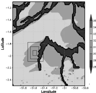
The Caxiuanã National Forest is a conservation unit consisting of a primary forest area in the municipality of Melgaço in central-western state of Para, approximately 400 km west of the capital Belém. The grid of the PPBio, in which the project has developed its research and data collection relating to biodiversity, is located at 1º57 ‘36.7920”S and 51º36’55.0800”W, within the limits of Caxiuanã National Forest (Figure 1).
2.1 Numerical model BRAMS
In this study we used the numerical model BRAMS (Brazilian Developments on Regional Atmospheric Modeling
System), version 4.2. This model version, adapted to Brazilian surface characteristics, is derived from the atmospheric model RAMS (Regional Atmospheric Modeling System) (Pielke et al. 1992; Cotton et al., 2003). This regional model has been widely used to study climatic and environmental processes in the Amazon region (Silva Dias et al, 2002a, 2004; Gandu et al., 2004; Ramos da Silva and Avissar, 2006; Cohen et al., 2007; Ramos da Silva et al., 2008). Its multiple applications allow simulating the atmospheric phenomena of meso and micro scale with different resolutions and can be used to understand the operation of convective systems and storms, estimating precipitation, wind, and temperature, and the study of interactions between regional atmosphere and biosphere. The BRAMS has several modules (sub-models) that simulates interacting processes such as the heat exchange between water and soil-vegetation-atmosphere (Walko et al, 2000a), the turbulent processes in the surface layer and boundary layer (Mellor and Yamada, 1974; Deardorff, 1980), the exchange of solar and thermal radiation (Harrington, 1997), and the microphysics of clouds and precipitation (Walko et al., 2000b).
The use of BRAMS in LES mode (Large Eddy Simulations), is generally applied in grids with cells smaller than 100 meters spacing, allowing to simulate the large eddies (LES) by using the parameterization option developed by Deardorff (1980). These simulations usually are performed over small domains due to the very high resolution that implies in a large number of grid points, and time steps in the order of seconds (Avissar and Schmidt, 1998; Avissar et al., 1998).
2.2 Field experiment COBRA-PARÁ
The COBRA-PARA (Caxiuanã: Observations of the
Biosphere River and Atmosphere of Para) ield experiment,
was conducted from October 30 to November 15, 2006. This
ield campaign aimed to make simultaneous measurements of the contributions of carbon luxes in the atmosphere, soil and
river, besides studying the role of local circulations on these measures in the region of Caxiuanã (COBRA-PA, 2006). In this
study we used the radiosonde proiles data recorded during the
experiment to provide the initial conditions and to evaluate the modeling simulations. The radiosondes were launched from a clearing in the Caxiuanã forest every 3-hour for the period of the experiment (Monteiro da Silva et al., 2010).
2.3 Description of numerical experiment
BRAMS was conigured with the surface characteristics
of the region such as local topography, vegetation and soil types. The model was set up with four interacting nested grids, with the large grid domain covering the limits of Caxiuanã National
Forest and its surroundings, and the smaller grid domain corresponding to the site of the PPBio research program (Figure 1). The large grid domain was set up with spatial resolution of 1350 meters, and the smaller grid with resolution of 50 meters. The intermediate grids had 450 and 150 m horizontal spacing, respectively. The vertical resolution was variable with initial spacing of 50 meters in the lowest layer of the model, increasing upward by a factor 1.1 to the vertical spacing of 800 meters,
which is ixed up to the top of the model. We also deined 12 soil
levels having the following depths: 0.2, 0.4, 0.6, 0.8, 1.0, 1.3, 1.5, 2.0, 3, 0, 3.5 and 4 meters. The surface water temperature
in the Bay of Caxiuanã was deined as constant with a value of
30.5 ° C based on measurements made during the experiment COBRA-PARA experiment. For the atmosphere it was adopted an initial condition based on a vertical profile obtained from a spatially homogeneous sounding collected during the Experiment COBRA-PARÁ for winds, temperature, and moisture. The boundary conditions adopted was an advecting type as developed by Klemp and Whilhelmsom (1978).
A numerical simulation was performed for a period of 24 hours to assess a daily evolution of the micro-and meso-scales processes and their interactions. The 24 hours simulated corresponded to the period between 12:00 UTC on November 7, 2006 and 12:00 UTC on November 8, 2006.
3. RESULTS AND DISCUSSION
Model performance was evaluated by comparing the model results with those obtained with the radiosondes during the COBRA-PARA ield experiment. The main meteorological variables evaluated were the zonal and meridional winds, temperature, relative humidity and the forest canopy temperature.
For the zonal wind (u) profiles, we observed the predominance of easterly trade winds for both the simulation and the observations (Figure 2a). The model results show strong winds (above 08 m/s) on 07 November, mainly in the layers between 1200 and 2500 meters. However, the persistence of strong observed winds were not well simulated by the model
for the irst hours of 08 November (not shown). These results
suggest that these jets are remote phenomena that propagate into the region. In fact, simulations by Cohen et al. (2006) showed that low level jets in this region should be caused by the
low drag coeficient of the water surfaces, especially over the
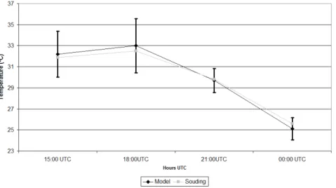
Figure 2 - Simulated proiles and radiosonde at 1800 UTC, for 07 November, 2006, namely: (a) zonal wind proile (u), (b) meridional wind (v), (c) temperature (° C) and (d) relative humidity (%).
UTC (Figure 2c) showed a difference of 1 ° to 2 ° C between the model results and the radiosoudings. Results for relative humidity
at 18:00 UTC show good agreement with the observed proile
mainly for the boundary layer (Figure 2d). For the levels between 1000m and 2700m the presence of clouds causes a high moisture
variability which is depicted by the nearby simulated proiles.
In general, the model simulated well the irst hours of
understand the convection evolution that occurs mainly during the daytime and over the PPBio site. Further studies should
include a high resolution boundary condition ields to produce
a nudging for this study region and allow longer integrations. Figure 3 shows a comparison between simulated canopy temperature and data recorded by the radiosonde, at approximately 20 meters above the ground. The simulation of canopy temperature shows that observed values from radiosonde were within the error bar indicating that the model simulated well the canopy temperature (Figure 3). The evolution of average temperature from canopy is satisfactory throughout the simulated period, compared with the values of temperature radiosoundings.
Figure 1 shows an important result on the interaction between the mesoscale and microscale in which we observe
the inluence of Caxiuanã Bay and other water bodies on the
canopy temperature variation near the rivers. The predominant northeast winds in this region advect the cooler temperatures toward west of bay affecting the canopy temperature at this time of the day (14:00 UTC).
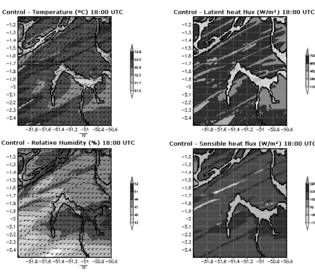
Figure 4 shows model results for temperature, relative
humidity, latent and sensible heat lux for 18:00 UTC. In general,
these meteorological variables show spatial patterns aligned with the northeasterly predominant winds. Further analysis show that at this time of the day near surface meteorological processes
and surface luxes are highly affected by the converging winds.
Above the Bay Caxiuanã and other water surfaces it is noted
that wind low is intensiied, indicating the inluence of the low roughness of these surfaces on the wind circulation. The luxes
of sensible and latent heat show a pattern that coincides with the
locations where the wind low is stronger. This pattern shows the
formation of hot plumes above the region at the indicated time,
as can be noticed in the ields of vertical motion (Figure 5a).
These results are consistent with observations from the MODIS images for this particular day (Figure 5b). Lower values in latent
heat lux are produced over the water surfaces indicating the
important hole of the forest on the transpiration and moisture transfer to the atmosphere.
The Large Eddy simulation (LES) obtained with the high resolution grid (grid 4) shows that spatial pattern of canopy
temperature is associated with the direction of wind low that
comes from northeast (Figure 6a). Analysis of model results shows that this pattern is seen until approximately 20:00 UTC. After that, the strong convection produces local storms that destroy this spatial pattern (Figure 6b).
The results also suggest a relationship between mid
level wind speed and sensible heat and latent heat luxes. The
spatial correlation between wind speed at the level of 735
meters and luxes of sensible and latent heat was analyzed for the grids 1, 2, 3 and 4. It is noted that for sensible heat luxes
(Figure 7), in the coarser grid 01, which simulates mesoscale phenomena, the spatial correlation with mid-level winds is negative. Probably this is due to mesoscale convective cells that form during the day and produce strong winds and gusts (downdrafts) with downward movements that inhibit the
sensible heat lux. The correlation is highly negative at the time
of 21:00 UTC when convection storms are very active. Results from the grids 3 and 4 show greater variability, but there is also a predominantly negative spatial correlation. This explains the
negative correlation between the winds and sensible heat lux at this time of the day. Analysis for the latent heat lux shows a
transition from negative to positive correlation over time (Figure 8). The grid shows a maximum correlation around 21:00 UTC, probably associated with mesoscale convective cells. Analysis for the LES (grid 4) shows a positive correlation especially at
dawn. These results suggest an inluence of the micro-scale
Figure 4 - Surface ields for grid 1, at the level of 24 m, at 18:00 UTC on November 7, 2006.
Figure 6 - (a) Canopy temperature (ºC) for grid 4 at 14:00 UTC on 7 November 2006; (b) Precipitation rate (mm/hr) and wind vectors for grid 4 at 21:50 UTC on 7 November 2006.
Figure 7 - Spatial correlation coeficient between the sensible heat
luxes and wind speed at the level of 735m.
Figure 8 - Spatial correlation coeficient between the latent heat luxes and wind speed at the level of 735m.
in the surface luxes such as the effect of local eddies, mainly
mechanically generated by the wind shear.
4. CONCLUSIONS
Meteorological data and high resolution numerical
simulations were used to estimate spatial ields in eastern
Amazonia where is located the Forest and the Bay of Caxiuanã and mainly near the site of the Project PPBIO experiments during the experiment COBRA-PA.
Analysis of the MODIS images show the occurrence of various phenomena such as local avenues of clouds,
precipitating convective system and an important inluence of
analysis show that the model simulates very well the canopy temperature, which is an important variable of interest to other researchers on the project PPBIO.
The results show that the Caxiuanã Bay causes major impact in the fields of canopy temperature, particularly downstream of the wind where the PPBio site is located. The advection by winds from the northeast produces cooler canopy temperatures over the west of the Bay as compared with temperatures in the east of the Bay. Thus, this mesoscale circulation is of fundamental importance for the local micro-climate of this region.
Simulations with high resolution capability (LES) show spatial patterns of temperature and humidity aligned with the winds during the daytime. The model results also showed that
stronger mid level winds cause less sensible heat lux and increased latent heat lux only in the early hours of the day. Spatial correlations for the latent heat luxes show that there is
a change from negative correlations during the early hours of the day into positive correlations for the afternoon and early
evening. This shows that the descendant lows associated with gust fronts have important inluences on the spatial distribution of surface luxes.
Although this case study has provided the irst micro-meteorological spatial ields for the region of PPBIO, it becomes
necessary in the future to explore other cases with different meteorological conditions.
5. ACKNOWLEDGMENTS
Renata Leitão da Conceição Mesquita thanks the
National Council for Scientiic and Technological
Development-CNPq - Brazil, the graduate student stipend granted. The authors thank the LBA project, Millennium LBA, PRONEX, Reman, PPBio of features provided for carrying out campaigns of data
collection, maintenance of ield sites, purchase of equipment,
among others.
6. REFERENCES
ANDREAE, M.O.; et al.: Biogeochemical cycling of carbon, water, energy, trace gases, and aerosols in Amazonia: The LBA-EUSTACH experiments. Journal of Geophysical Research, v. 07, n.8066, p.1-25, 2002.
AVISSAR, R.; SCHMIDT, T. An Evaluation of the Scale at which Ground-Surface Heat Flux Patchiness Affects the Convective Boundary Layer Using Large-Eddy Simulations. Journal of Atmospheric Science, v.55, p.2666-2689, 1998. AVISSAR, R.; ELORANTA, E.W.; GÜRER, K.; TRIPOLI, G.J.
An Evaluation of the Large-Eddy Simulation Option of the Regional Atmospheric Modeling System in Simulating a
Convective Boundary Layer: A FIFE Case Study. Journal of Atmospheric Science, v.55, p.1109-1130, 1998. COBRA-PARÁ. Caxiuanã: Observações na Biosfera, Rios e
Atmosfera no Pará, 2006. Disponível em: http://www3. ufpa.br/cobra-para/objetivos.php. Acesso em: 20 mai.2008. COHEN, J.C.P.; SÁ, L.D.A.; NOGUEIRA, D.S.; GANDU,
A.W. Jatos de baixos níveis acima da loresta Amazônica
em Caxianã. Revista Brasileira de Meteorologia, v.21, n.3b, p. 271-282, 2006.
COHEN, J. C. P.; BELTRÃO, J. C.; GANDU, A. W.;
RAMOS-DA-SILVA, R. Inluência do desmatamento sobe o ciclo
hidrológico na Amazônia. Ciência e Cultura, ano 59, n.3, p.36-39, 2007.
COTTON, W.R.; PIELKE, R.A.; WALKO, R.L.; LISTON, G.E; TREMBACK, C.J.; JIANG, H.; MCANELLY, R.L.; HARRINGTON, J.Y.; NICHOLLS, M.E.; CARRIO, G.G.; MCFADDEN, L.P. RAMS: Current Status and future directions. Meteorology and Atmospheric Physics. v.82, n.1-4, p.5-29, 2003.
DEARDORFF, J. W. Stratocumulus-capped mixed layers derived from a 3-dimensional model. Boundary-Layer Meteorology., v.18, p.495–527, 1980.
GANDU, A. W.; COHEN, JCP ; SOUZA, J. R. S. Simulation of deforestation in eastern Amazonia using a high-resolution model. Theoretical and Applied Climatology, v. 78, n. 1-3, p. 123-135, 2004.
HARRINGTON, J. Y. The effects of radiative and microphysical processes on simulated warm and transition season arctic stratus. Ph.D. dissertation. Colorado State University, 1997. 289 p.
KLEMP, J.B.; WILHELMSON, R.B. The simulation of threedimensional convective storm dynamics. Journal of Atmospheric Science , v.35, p. 1070–1096, 1978.
MELLOR, G. L.; YAMADA, T. A hierarchy of turbulence closure models for planetary boundary layers. Journal of Atmospheric Science, v.31, p.1791–1806, 1974.
MODIS Rapid Response Project at NASA/GSFC. Imagens do
sensor MODIS, 2006. Disponível em: http://www.rapidire.
sci.gsfc.nasa.gov .Acesso em: 13 ago. 2008.
MONTEIRO DA SILVA, L.; SÁ, L.D.A.; MOTA, M.A.S. Avaliação de características dos regimes de umidade na Flona de Caxiuanã-PA durante o Experimento COBRA-PARÁ. Revista Brasileira de Meteorologia, v.25, n.1, p. 01-12, 2010.
NOBRE, C.A.; SELLERS, P.; SHUKLA, J. Regional climate change and amazonian deforestation model. Journal of Climate, v. 4, p. 957- 988. 1991.
OYAMA , M.D.; NOBRE, C.A. A new climate-vegetation equilibrium state for Tropical South America. Geophysical Research Letters, v.30, n. 23, p.1-4. 2003.
PIELKE, R. A.; COTTON, W. R.; WALKO, R. L.; TREMBACK, C. J.; LYONS, W. A.; GRASSO, L. D.; NICHOLLS, M. E.; MORAN, M. D.; WESLEY, D. A.; LEE, T. J.; OPELAND, J. H. A Comprehensive Meteorological Modeling System - RAMS. Meteorology and Atmospheric Physics. v. 49, n. 1-4, p. 69-91, 1992.
PÖSCHL, U. el al.: Rainforest aerosols as biogenic nuclei of clouds and precipitation in the Amazon. Science, n.329, p.1513-1516, 2010
RAMOS DA SILVA, R.; R. AVISSAR. The hydrometeorology of a deforested region of the Amazon.Journal of Hydrometeorology, n.7, p.1028-1042, 2006.
RAMOS DA SILVA, R.R.; MOTA, M.A.; COHEN, J.C.P.; GANDU, A.W. Progressos na detecção e previsão de eventos meteorológicos extremos na Amazônia Oriental. Boletim da Sociedade Brasileira de Meteorologia, v.31, n.2-3, p.14-20, 2007.
RAMOS DA SILVA, R.; WERTH, D.; AVISSAR R. Regional Impacts of Future Land-Cover Changes on the Amazon Basin Wet-Season Climate. Journal of Climate, n.21 v.6, p.1153-1170, 2008.
RUIVO, M.L.P.; BARREIROS, J.A.P.; BONALDO, A.B.;SILVA, R.S.; SÁ, L.D.A.; LOPES, E.L.N.
LBA-ESECAFLOR Artiically induced drought in Caxiuanã
Reserve eastern Amazonia: soil properties and litter spider fauna. Earth Interacions, n.8, v.11, p.1-13, 2007.
SILVA DIAS, M. A. F. et al.: Clouds and rain processes in a biosphere atmosphere interaction context in the Amazon Region. Journal of Geophysical Research, n. 107, n. D20, p. 8072-8092, 2002a.
SILVA DIAS, M. A. F.; SILVA DIAS, P. L.; LONGO, M.; FITZJARRALD, D. R.; DENNING, A. S. River breeze circulation in eastern Amazonia: observations and modelling results. Theoretical and Applied Climatology, n.78, p.111–121, 2004.
WALKER, B.H.; SALT, D. Resilience Thinking: Sustaining Ecosystems and People in a Changing World. USA: Island Press, 2006. 174p.
WALKO, R.L.; BAND, L.E.; BARON, J.; KITTEL, T.G.F.; LAMMERS, R.; LEE, T.J.; OJIMA, D.; PIELKE, R.A.; TAYLOR, C.; TAGUE, C.; TREMBACK, C.J.; VIDALE, P.L. Vidale. Coupled Atmosphere–Biophysics–Hydrology Models for Environmental Modeling. Journal of Applied Meteorology., 39, 931–944, 2000a.