TOPOGRAPHIC REGISTERS OF PALEO-VALLEYS ON THE SOUTHEASTERN
BRAZILIAN CONTINENTAL SHELF
Luis Américo Conti1,2 and Valdenir Veronese Furtado2
1
Escola de Artes Ciências e Humanidades – Universidade de São Paulo (Av. Arlindo Bettio, 1000, 03820-000 São Paulo, SP, Brasil)
2
Instituto Oceanográfico da Universidade de São Paulo (Praça do Oceanográfico, 191, 05508-120 São Paulo, SP, Brasil)
A
B S T R A C TThe evolution of paleo-incised-valleys in the São Paulo State region of the southeastern Brazilian continental shelf is presented in this study in relation to the post Last Glacial Maximum (LGM) sea-level rises based on the submarine topography modeled by a detailed Digital Elevation Model and evidences noted in high resolution seismic profiles. The hypothesis that has guided this study is that the set of paleo-valley characteristics (i.e. the fluvial parameters of modern coastal drainage systems, the topographical shape and dimensions of the valleys and of the subsurface channels) may indicate aspects of the relation between the influence of the fluvial and the eustatic variation regime in geomorphological-stratigraphic registers. Models described in the literature sustain the view that faster marine transgressions tend to increase erosion in estuaries, which may explain the lack of registers of paleo-drainage both in topography and the sub-surface in areas with wider shelves. On the other hand, on narrower shelves, with a higher slope angle, the transgression process can preserve, or even enhance, the incised valley registers during shoreface retreat. In the area studied, we observed that the dimensions and form of the continental shelf varies from the northern to the southern part of the area, affecting aspects of the geomorphological registers of the submerged incised valleys.
R
E S U M OEste trabalho apresenta aspectos da relação entre a evolução da paleo-drenagem e evolução do nível do mar pós Último Máximo Glacial (UMG) para a região da plataforma continental do Estado de São Paulo. Para tal, foram analisados modelos topográficos de detalhe da região de Plataforma Continental a partir de Modelos Digitais de Terreno além de dados de subsuperfície obtidos a partir de linhas sísmicas de alta resolução. A hipótese que guiou este trabalho é de que o conjunto de características relativas aos paleo-vales (i.e. sua relação com a rede de drenagem atual, tamanho e forma dos vales em topografia de fundo além das características das feições de incisão dos canais em subsuperfície) podem caracterizar a relação entre a processos fluviais e eustáticos na formação desses registros geomorfológicos e estratigráficos. Modelos descritos na literatura sugerem que rápidas transgressões marinhas tendem a amplificar o efeito erosivo da passagem da linha de costa e afogamento dos canais estuarinos o que poderia explicar a falta de registros de paleodrenagem em plataformas continentais planas e largas; por outro lado, em plataformas mais estreitas e mais declivosas os processos regressivos podem preservar (ou até realçar) tais feições. Na área de estudo, foi possível observar que diferentes características de forma e dimensões da plataforma continental ao norte e sul da área estudada condicionaram o estabelecimento e preservação dos registros de paleodrenagem.
Descriptors: Continental shelf, Incised valleys, Bathymetry, Digital terrain model. Descritores: Plataforma continental, Paleo-vales, Batimetria, Modelo digital de terreno.
I
NTRODUCTIONThe characteristics and distribution of paleo-drainage registers were studied as an indicator of the evolution of the continental shelf evolution over the last regressive period (Post Last Glacial Maximum -18 ky BP) when most of the world´s shelves were exposed to subaerial erosional processes. Several __________
Contr. No. 879 do Inst. oceanogr. da Usp.
chanel incision surface and its relation to quaternary stratigraphy based on seismic analysis (THORNE, 1994; LERICOLAIS et al., 2001; HORI et al., 2002; NORDFJORD et al., 2005; SCHIMANSKI and STATTEGGER 2005), it is possible to identify and classify the main paleo-valley axis in the surface topography even though they are covered by marine sediments deposited during and after rises in sea-level (CORREA, 1996; HARRIS; O'BRIEN, 1996; COLLINA-GIRARD, 1999; ABREU; CAGLIARI, 2005; FINKL et al., 2005; STRAUB et al., 2007).
Different sedimentation model approaches focus on the erosion and valley incision during relative sea-level rises or falls (DALRYMPLE et al., 1994; ASHLEY; SHERIDAN, 1994; ZAITLIN et al., 1994), but there are few studies that characterize the topographic expression of the paleo-drainage registers. In order to address these issues this paper focuses on a geomorphological approach, analyzing aspects of submarine relief related to drainage patterns and regional morphological settings of the continental shelf based on Digital Elevation Model (DEM) processing.
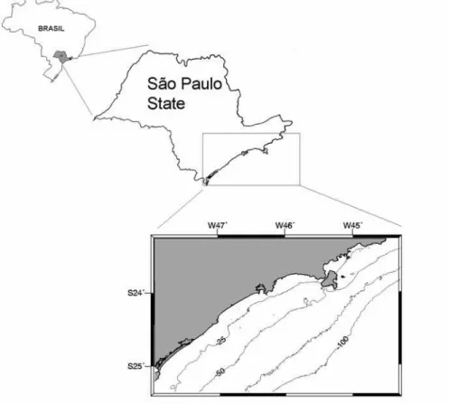
Study Site
Figure 1 shows the study site location. The continental shelf of São Paulo State, Brazil is a portion of a greater geomorphological region of the southeastern Brazilian coast called “Embaimento de São Paulo” (São Paulo Bight), an arc-shaped sector of the southeastern Brazilian margin extending from 23°S to 28°S (ZEMBRUSCKI, 1979). The geology and topography of the continental area is characterized by the Meso-Cenozoic tectonic processes that generated the mountainous landscapes known as “Serra do Mar”. This high relief area was thought to be the result of the erosional retreat of the major bounding fault scarps of the Santos Basin. Recent studies have suggested that the Serra do Mar evolved in two stages (ZALAN; OLIVEIRA, 2005). The first experienced a major uplift at the end of the Cretaceous, possibly related to alkaline magmatism (underplating), giving rise to a mega-plateau (300,000 km2). This uplift was followed during the Cenozoic by
the gravitational collapse of this mega-plateau leading to the formation of a series of rifts parallel to the coast, some of them presently located on the continental shelf (DOMINGUEZ, 2009). In the northern zone of
the study area, this feature lies parallel to the coastline (with mean altitudes of 800m) presenting irregular contour pattern that characterizes the coastal morphology, and gives way to several scarps intercalated with small coastal plains and pocket beaches. This particular characteristic has determined the development of several small size fluvial basins and the absence of major rivers. Due to the prevalence of a humid, tropical climate, leached materials eroded from the Serra do Mar are transported and discharged into the ocean by small creeks and debris flow down the hill slopes. The distance between the Serra do Mar and the shoreline increases in the southern region of the study area, allowing for the development of a coastal plain, the establishment a wider drainage system and the existence of the “Ribeira de Iguape” river.
The hydrodynamic conditions on the inner shelf are strongly dominated by wind- and wind wave-driven currents, but as suggested by Mahiques et al., 2002 and 2005, the sedimentation regime on the middle and outer shelves as well as on the upper slope are strongly influenced by the flow of the Brazil Current (BC).
The characteristics of the surface sediments of the Brazilian margin have been studied by several authors, including Millimann (1978), Mahiques et al. (2004) and Conti and Furtado (2006). The distinguishing characteristic observed is the predominance of fine palimpsest sands with considerable influence of mud and silt sediments in the southern part of the study area, probably to be associated with the influence of the La Plata river discharge.
M
ETHODSThe bathymetric data used in this work were the product of multiple hydrography soundings performed by the “Diretoria de Hidrografia e Navegação (DHN)” of the Brazilian Navy. Sixty-five thousand bathymetric points were computed to generate a Digital Elevation Model (DEM) of the area. Due to the high density of bathymetric samples, a simple kriging method was used to interpolate the data and generate a grid of the area, with dimensions of 2,331 lines by 3,696 columns with cell dimensions of 100 x100 meters.
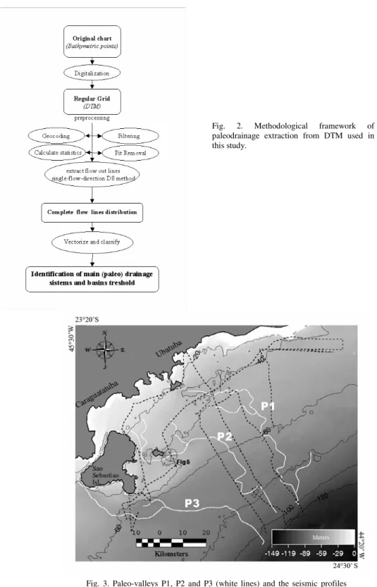
The bathymetric DEM grid was submitted to a set of processing operations to identify the drainage network pattern. This was preceded by a set of preprocessing operations such as the use of enhanced and high-pass filters and “pit removal operations”. Pits and local depressions in raster digital elevation models have been unavoidable obstacles in the extraction of drainage networks so several algorithms have been developed in order to overcome this problem. Most of the “terrain analysis” software packages have
algorithms for mathematical correction of topographical surfaces. The method used in this study has been based on the algorithm described by Planchon and Darboux (2001). Since the post transgressive marine processes tend to homogenize the shelf topography and disturb the continuity of the channels and valleys, the DEM was also submitted to the “breaching'” algorithm described by Rieger (1998). The algorithm valuates the local outlet of each closed depression in a DEM to determine whether the elevation of one or two cells at the outlet could be lowered to eliminate or reduce the size of the depression without reversing the direction of overland flow across the outlet (MARTZ; GARBRECHT, 1999).
The paleo-drainage network itself was extracted from the bathymetric grid using the algorithm of Runoff extraction “single-flow-direction D8 method” described in O’Callahan and Clark (1984). This method compares the elevation of each grid cell with the elevations of its eight adjacent neighbours (i.e. each cell within one row and one column) and a single flow direction is assigned along the steepest down-slope path. The surface drainage pattern defined by these overland flow directions allows for the derivation of the upstream drainage area or flow accumulation for each cell. Once the drainage network is delineated, the contributing areas for the source nodes of exterior links, and the contributing areas for both left and right banks of all channel links are identified (Lacroix et al., 2002). The next step was to classify the flow lines on the basis of the Strahler Stream Order algorithm (Strahler,1964). Highest order flow paths were vectorized and identified as the main paleo-valleys.
Due to the very gentle declivity angle of the continental shelf, it was impossible to extract further quantitative parameters from the model since most of the topographical characteristics of the original erosive terrain were masked; however, the main flow direction can still be preserved and identified. Figure 2 shows the methodological framework of the drainage extraction from Digital Terrain Models.
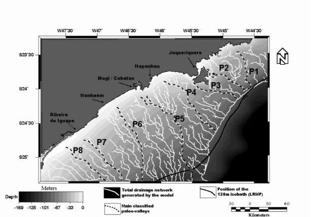
In order to characterize some of the incised channels in the subsurface of specific areas and correlate them with the paleo-valleys extracted from the DTM, registers of high-resolution sub-bottom profiles acquired by a Sparker were also analyzed. The profiles were located in the northeastern part of the area near São Sebastião island. The seismic source system was a 1000 J sparker fired at 1.6 second intervals. Figure 3 shows the location of the seismic survey .
Fig. 3. Paleo-valleys P1, P2 and P3 (white lines) and the seismic profiles positions (broken black lines). The circle in central part of the Figure indicates the location of the register presented in Figure 5.
R
ESULTSFigure 4 shows the distribution of the main paleo-valley network axis generated by the DEM. This paleo-drainage model shows a reasonable correlation with modern fluvial systems: eight main runoff valleys were identified, five of which can be directly associated with one single river and the other three have no direct link with present individual drainage valleys.
The most northerly valley (identified as “P1”) does not have a significant river associated with it although the geomorphology of the mainland may indicate the following. The Serra do Mar mountain complex is particularly close to the shore on this segment of the coast, which did not allow for the identification of important river basins; however, during transgressive periods, with the continental shelf exposed, all established drainage patterns should converge into one large river and be identified by the model. This submerged valley basin, calculated to have an area of 980,000 acres or approximately 4,000
square kilometers, is of regular shape. This feature can be tracked down to a depth of 128 meters.
São Sebastião island controls the configuration of the paleo-valleys already identified and described by Zembrusky (1979) and Furtado et al. (1996) as Búzios and São Sebastião, respectively, corresponding to the P2 and P3 of this present study. These systems are two of the most clearly distinguishable channel formations on the southeastern Brazilian shelf despite the absence of large rivers in this area of the coastal zone.
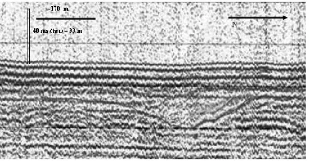
The most significant river is the Juqueriquerê, with a mean outflow of less than 20m3/s, being too small, therefore, to cut such an immense channel on the shelf. Both P2 and P3 attain a depth of 120 meters near the Last Regressive Maximum Position (LRMP), as seen Figure 4. Channel incision structures also can be seen in the upper reflectors on the seismic profiles (Fig. 5) in both cases, the presence of cut/fill features accompany the valleys down to a depth of approximately 75 meters.
Fig. 5. Sparker profiles indicating typical incised channel structures from the paleo-valley P2. twt = Two way time.
The paleo-valleys P4, P5 and P6 cover the widest part of the shelf for more than 100 km from the modern coastline to the LRMP. They are, nevertheless, clearly marked on the topography despite there being no registers of them on the middle and outer shelf seismic lines. The only channel features found on the seismic profiles are linked to the P5 valley on the inner shelf at the depth of 25 meters. The drainage associated with P4 and P5 is from rivers and creeks with a mean outflow of below 20 m3/s as in the case of the Santos, Mogi and Itapanhaú rivers. The P6 is clearly connected to the Itanhaém River, one of the largest river systems of the region with a mean outflow of 80 m3/s.
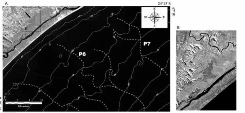
The largest river in the area is the Ribeira de Iguape with a mean outflow of 300 m3/s (with maximum values greater than 1500 m3/s). It
presents one paleo-valley associated with a topographical expression beginning at the 25 m isobath closely linked to the actual river mouth (P7). Further south, approximately 5 km away, another valley feature runs parallel to the first(P8). Based on the size of the valleys and their positions, it is reasonable to suppose that both features were linked to the Ribeira de Iguape River, which indicates a channel migration. P8 points to the middle of a barrier island called “Comprida” (Long Island) associated with a lagoonal system. Suguio and Martin (1978) described the evolution of the Comprida Island as a late Pleistocenic/Holocenic accretion with northward direction determined mainly by long-shore current processes.
An abandoned valley feature characterized by high humidity and typical vegetation was observed in coastal areas, on Landsat ETM+ Images, at the projected point of convergence of the two paleo-valleys. Seismic lines acquired between the Comprida island and the mainland showed a clearly defined incised channel exactly at the point projected from the P8.
The representation of the bathymetry (with the paleo-valleys) and the satellite image may be seen in Figure 6.
D
ISCUSSIONFig. 6. A. Combination of satellite image (Band TM-4 - near infrared spectral band), isobaths and main paleo-valley network (broken grey lines). B- Detailed region of the supposed abandoned valley (characterized by darker areas) from Ribeira de Iguape River converging on the shelf paleo-valley P8 identified by the DTM.
In the case of the Ribeira de Iguape river, especially, none of two paleo-valleys on the continental shelf presented any register of channel features in the subsurface on the continental shelf, only inside the lagoon system. This may be due to the fact that the sand that forms the basin on the shelf is the same as that covering it in transgressive processes, not producing enough impedance contrast between the seismic units.
Koss et al. (1994), Ashley and Sheridan (1994), Gutierrez et al. (2003), Weber et al. (2004) and
Hori et al. (2002) report that continental shelves correlate poorly with the hydrological fluvial regime and are associated more with the sea level fluctuation and the submerging processes of the incised valleys during marine transgressions. In the case of the present study area, the most remarkable paleo-valleys were found on the northern part of the shelf (e.g. P1, P2, P3), where the shelf is narrower. In the southwestern region, the paleo-valleys became smoother, even with larger rivers associated, as seen in Figure 7.
C
ONCLUSIONSIncised paleo-valleys on continental shelves can leave traces not only in the subsurface but also in the submarine topography, although these registers can be very subtle and difficult to identify. Consequently, the DEM can be a valuable tool for extracting and analyzing such continental shelf paleo-drainage systems.
In this study, DEM identified 8 main paleo-valley systems which show different degrees of correlation with the modern coastal drainage pattern. This characteristic indicates that the sea-level rise rate and the posterior marine erosion/deposition may have more influence on the size and shape of the drowned channels than their original topographic or hydrographic characteristics. The study site presents two different paleo-valley characteristics: Northward from São Sebastião island where the shelf is narrower, the paleo-valley registers on the topography are more evident even where there are no considerable river basins. These three paleo-valley (P1, P2 and P3) systems also present clear cut and fill registers in the sub-surface, as indicated in seismic profiles. Southward from São Sebastião Island, where the two largest rivers are located (Ribeira de Iguape and Itanhaém), the topographical registers are quite smooth and there are very few good seismic registers of channel features. The continental shelf in this area is almost 70% wider, so the horizontal marine transgression was considerably faster than on the northern shelf, which is consistent with the model developed by Koss et al.(1994) who propose that faster marine transgressions tend to increase the erosional processes in river mouths, thus explaining the lack of registers in the topography and the sub-surface.
A
CKNOWLEDGEMENTSThe authors wish to thank Dr Michel M. Mahiques of the Instituto Oceanográfico – USP and Dr Luis Antônio Pereira de Souza of the IPT (Instituto de Pesquisas Tecnológicas). This research project was financed by FAPESP (04/13575-2).
R
EFERENCESABREU, J. G. N.; CALLIARI, L. J. Paleocanais na plataforma continental interna do Rio Grande do Sul: evidências de uma drenagem fluvial pretérita. Revta Brasil. Geof., v. 23, p. 123-132, 2005.
ASHLEY, G. M.; SHERIDAN, R. E. Depositional model for valley fills on a passive continental margin. In: DALRYMPLE, R. W.; BOYD, R.; ZAITLIN, B. A. (Ed.). Incised-valley systems: origin and sedimentary
sequences. Spec. Publs Soc. econ. Paleont. Miner.,
Tulsa, v. 51, p 285-302, 1994.
BLUM, M. D.; THORNQVIST, T. Fluvial responses to climate and sea level changes. a review and look foward. Sedimentology, v. 47 (supl. 1), p. 2-48, 2000.
COLLINA-GIRARD, J. Observation en plongee de replats d’erosion eustatique a l’ile d’Elbe (Italie) et a Marie-Galante (Antilles): une sequence bathymetrique mondiale. C.r. Acad. Sci, . Paris, v. 328, p. 823–829, 1999
CONTI, L. A.; FURTADO, V. V. Geomorfologia da Plataforma Continental do estado de São Paulo. Revta Brasil. Geociên., v. 32, p. 12-31, 2006.
CORREA, I. C. S. Les variations du niveau de la mer durant les derniers 17.500 ans BP: l'exemple de la plate-forme continentale de Rio Grande do Sul — Brésil, Mar. Geol., v. 130, p. 163–178, 1996.
DALRYMPLE, R. W.; BOYD, R.; ZAITLIN, B. A. History of research, types and internal organization of incised-valley systems: introduction to the volume. In: DALRYMPLE, R. W.; BOYD, R.; ZAITLIN, B.A. (Ed.). Incised-valley systems: Origin and sedimentary
sequences. Spec. Publs Soc. econ. Paleont. Miner., Tulsa, n. 51, p. 3-10, 1994.
DOMINGUEZ, J. M. L. The Coastal zone of Brazil. In: DILLENBURG, S. R.; HESP, P. A. (Ed.). Geology and
geomorphology of Holocene coastal barriers of Brazil.
Berlin / Heidelberg: Springer Verlag, 2009.
FINKL, C. W.; BENEDET, L.; ANDREWS, J. L. Interpolation of seabed geomorphology based on spatial analysis of high-density airborne laser bathymetry. J. coast. Res. , v. 21, n. 9, p. 501-514, 2005.
FURTADO, V. V., BONETTI FILHO, J.; CONTI, L. A. Paleo river valley morphology and sea level changes on the southeastern Brazilian Continental Shelf. An. Acad.
Bras. Ciênc., v. 68 (supl. 1), p. 163-169, 1996.
GUTIERREZ, B. T.; UCHUPI, E.; DRISCOLL, N. W.; AUBREY, D. G. Relative sea-level rise and the development of valley-fill and shallow-water sequences in Nantucket Sound, Massachusetts. Mar. Geol., v. 193, p.295 -314, 2003
HARRIS, P. T.; O’BRIEN, P. E. Geomorphology and sedimentology of the continental shef adjacent to MacRobertson Land, East Antarctica: A scalped shelf.
Geo-Marine Letts, v. 16, p .287-296, 1996.
HORI, K.; SAITO, Y.; ZHAO, Q; WANG, P. Control of incised-valley fill stacking patterns by accelerated and decelerated sea-level: the Changjiang example during the last deglaciation. Geo-Marine Letts, v . 22, p. 127-132, 2002.
KOSS, J. E.; ETHRIDGE, F.; SCHUMM, S. A. An experimental study of the effects of base-level change on fluvial, coastal plain and shelf systems: J. sedim. Res., v. 64, p. 90-98, 1994.
LACROIX, M. P.; MARTZ, L. W.; KITE, G. W.; GARBRECHT, J. 2002. Using digital terrain analysis modeling techniques for the parameterization of a hydrologic model, Environ. Model. Software, 17, p. 127–136.
LERICOLAIS, G. ; AUFFRET, J. P. ; BOURILLET, J. F. The Quaternary Channel River : seismic stratigraphy of its palleo-valleys and deeps. J. Quat. Sci., v. 18, p. 245-260, 2003.
MAHIQUES, M. M.; SILVEIRA, I. C. A.; SOUSA, S. H. M.; RODRIGUES, M. Post-LGM sedimentation on the outer shelf–upper slope of the northernmost part of the São Paulo Bight, southeastern Brazil. Mar. Geol., v. 181, n. 4, p. 387-400, 2002.
MAHIQUES, M. M.; TESSLER, M. G.; CIOTTI, A. M.; SILVEIRA, I.C.A.; SOUSA, S.H.M.; FIGUEIRA, R.C.L.; TASSINARI, C.C.G.; FURTADO, V.V. and PASSOS, R.F.. Hydrodynamically-driven patterns of recent sedimentation in the shelf and upper slope off southeast Brazil. Continent Shelf Res 24: 1685-1697, 2004.
MAHIQUES, M. M.; BÍCEGO, M. C.; SILVEIRA, I. C. A.; SOUSA, S. H. M; LOURENÇO, R. A. and FUKUMOTO, M.M.. Modern sedimentation in the Cabo Frio upwelling system, Southeastern Brazilian shelf. An Acad Bras Cienc 77: 535-548. 2005
MARTZ, L. W. ; GARBRECHT, J. An outlet breaching algorithm algorithm for the treatment of closed depressions in a raster DEM. Computers, Geoscienses, v. 25, p. 835-844, 1999.
MEIJER, X. D. Modelling the drainage evolution of a river-shelf system forced by Quaternary glacio-eustasy. Basin Res.,v. 14, n. 3, p. 361-377, 2002.
MILLIMAN, J. D. Morphology and structure of the upper continental margin of Southern Brazil, Bulletin of the American Association of Petroleum Geologists 62, pp. 1029–1048. 1978
NORDFJORD, S.; GOFF, J. A.; AUSTIN, JR., J. A.; SOMMERFIELD, C. K. Seismic geomorphology of buried channel systems on the New Jersey outer shelf: Assessing past environmental conditions. Mar. Geol.,v. 214, p. 339-364, 2005.
O'CALLAGHAN, J. F.; MARK, D. M. The extraction of drainage networks from digital elevation data. Comput. Vis., Graph., Image process., v. 28, p. 323–344, 1984. PLANCHON, O.; DARBOUX, F. A fast, simple and
versatile algorithm to fill the depressions of digital elevation models. Catena, v. 46, p. 159–176, 2001. REYNAUD, J.; TESSIER, B.; PROUST, J. N.,
DALRYMPLE, R., BOURILLET, J. F.; DEBATIST, M.; LERICOLAIS, G.; BERNÉ, S.; MARSSET, T. Architecture and sequence stratigraphy of a Late Neocene incised valley at the shelf margin, Southern Celtic Sea. J. sedim. Res., v. 69, n. 2, p. 351-364, 1999.
RIEGER, W. A phenomenon-based approach to upslope contributing area and depressions in DEMs. Hydrolog. Processes , v. 12, p 857-872, 1998.
SCHIMANSKI, A.; STATTEGGER, K. Deglacial and Holocene evolution of the Vietnam shelf: stratigraphy, sediments and sea-level change. Mar. Geol. , v. 214, p. 365– 387, 2005.
STRAHLER, A. N. Quantitative geomorphology of drainage basins and channel networks. In: VEN TE CHOW (Ed.)
Handbook of applied hydrology. New York: McGraw-
Hill, 1964.
STRAUB, K. M.; JEROLMACK, D. J.; MOHRIG, D.; ROTHMAN, D. H. 2007. Channel network scaling laws in submarine basins. Geophys. Res. Lett., v. 34,2007. L12613, doi:10.1029/2007GL030089.
SUGUIO, K.; MARTIN, L. Quaternary marine formations of the states of São Paulo and southern Rio de Janeiro. In: INTERNATIONAL SYMPOSIUM ON COASTAL EVOLUTION IN THE QUATERNARY, 1978, São Paulo. Spec. Publ. , n. 1, p 1-55, 1978.
TESSON, M.; LABAUNE, C.; GENSOUS, B. Small rivers contribution to the Quaternary evolution of a Mediterranean littoral system: The western gulf of Lyon, France. Mar. Geol., v. 222– 223, p. 313–334, 2005. THORNE, J., 1994. Constraints on riverine valley incision
and the response of sea-level change based on fluid mechanics. In: DALRYMPLE, R.W.; BOYD, R.; ZAITLIN, B.A. (Ed.). Incised-valley systems: Origin and sedimentary sequences: Spec. Publs Soc. econ. Paleont. Miner., Tulsa, n. 51, p. 29–44, 1944.
WEBER, N. ; CHAUMILLON, E.; TESSON, M. ; GARLAN, T. Architecture and morphology of the outer segment of a mixed tide and wave-dominated-incised valley, revealed by HR seismic reflection profiling: the paleo-Charente River, France. Mar. Geol., v. 207, p. 17–38, 2004.
ZAITLIN, B. A.; DALRYMPLE, R. W.; BOYD, R. The stratigraphic organization of incised-valley systems associated with relative sea-level change. In: DALRYMPLE, R.W.; BOYD, R. B.A. ZAITLIN, B. A. (Ed.). Incised-valley systems: Origin and sedimentary sequences. Spec. Publs Soc. econ. Paleont. Miner., Tulsa,n. 51, p. 45–62, 1994.
ZALÁN, P. V.; OLIVEIRA, J. A. B. Origem e evolução estrutural do Sistema de Riftes Cenozóicos do Sudeste do Brasil. Bolm Geociênc. Petrobras, v. 13, n. 2, p. 269-300, 2005.
ZEMBRUSCKI, S. G. Geomorfologia da Margem Continental Sul Brasileira e das Bacias Oceânicas Adjacentes. In: CHAVES, H. A. F. (Ed.). Geomorfologia da margem continental Brasileira e
das áreas oceânicas adjacentes. Rio de Janeiro:
REMAC, 1979. p. 129-174. REMAC Project n. 7.