www.rbgf.org.br
DOI: 10.22564/rbgf.v37i4.2028
GEOELECTRIC CHARACTERIZATION FOR IMPLANTATION A LANDFILL
IN SIMÕES FILHO, BAHIA, BRAZIL
Rogério de Jesus Porciúncula
1and Luiz Rogério Bastos Leal
2ABSTRACT.The present study brings the results from the integration of applying a geoelectrical method and direct investigation methods in the qualitative and quantitative characterization of the geological-geotechnical environment. The purpose was to establish a local hydrostratigraphic model, in order to survey information that would aid in the implementation of cells for the final destination of urban solid waste over the sediments of the São Sebastião Formation, in Simões Filho, Bahia, Brazil. Twelve vertical electrical soundings, two SPT soundings and one geological sounding composed the quantitative surveys and techniques used. Unidimensional inversions presented mean error of 4.1%. Bidimensional inversions presented 5.7% mean error. Lower-value geoelectrical facies (< 1,000 Ohm.m) were attributed to occurrences between the silt and clay fraction, while higher-value facies (> 1,000 Ohm.m) corresponded to occurrence between the silt and sand fraction. The hydrostratigraphic model included a confined aquifer, represented by a succession of alternating sandy and clay-rich layers with subhorizontal contact, often laterally truncated, with at least two thick layers of clay occupying the first 100 m in depth. Moreover, water occurred in permeable porous layers, between depths of 40 and 50 m, approximately. Regarding the degree of compactness, in the first 100 m in depth, soils were classified as medium to hard.
Keywords: final waste disposal cells, geoelectrical method, hydrostratigraphic model, standard penetration test.
RESUMO.O presente estudo traz os resultados da integração do método geoelétrico a métodos diretos de investigação, utilizados para caracterização qualitativa e quantitativa do ambiente geológico-geotécnico. O propósito foi estabelecer o modelo hidroestratigráfico local, de modo a levantar informações que auxiliem na implantação de células de destinação final de resíduos sólidos urbanos sobre os sedimentos da Formação São Sebastião, no município de Simões Filho, Bahia. Doze sondagens elétricas verticais, 02 sondagens SPTs e 01 sondagem geológica compuseram o quantitativo de ensaios e técnicas utilizados. As inversões unidimensionais apresentaram erro médio de 4,1%. As inversões bidimensionais, de 5,7%. Os fácies geoelétricos de menores valores (<1.000 Ohm.m) estão atribuídos à ocorrência entre a fração síltica e a argilosa, e de maiores valores (>1.000 Ohm.m), à ocorrência entre a fração síltica e a arenosa. O modelo hidroestratigráfico inclui um aquífero do tipo confinado, representado por uma sucessão de camadas arenosas e argilosas intercaladas em contato subhorizontal, por vezes truncadas lateralmente, com no mínimo duas camadas espessas de argila nos primeiros 100 m de profundidade, e ocorrência de água, quando em camadas permoporosas, entre as cotas de 40 a 50 m, aproximadamente. Quanto ao estado de compacidade, nos primeiros 10 m de profundidade, os solos são classificados como médio a rijo.
Palavras-chave: células de disposição final de resíduos, método geoelétrico, modelo hidroestratigráfico, SPT.
Corresponding author: Rogério de Jesus Porciúncula
1Universidade Federal do Recôncavo da Bahia, Centro de Ciências Agrárias, Ambientais e Biológicas (CCAAB), Núcleo de Estudos dos Impactos da Mineração (NEIM), Rua Rui Barbosa, 710, Centro, 44380-000, Cruz das Almas, BA, Brazil – E-mail: porciuncula@ufrb.edu.br
2Universidade Federal da Bahia, Instituto de Geociências, Núcleo de Estudos Hidrogeológicos e do Meio Ambiente (NEHMA), Rua Barão de Geremoabo, S/N, Federação, 40050-090, Salvador, BA, Brazil – E-mail: lrogerio@ufba.br
482
GEOELECTRIC CHARACTERIZATION FOR IMPLANTATION A LANDFILLINTRODUCTION
The issue of final disposal of solid waste is a recurring problem in most urban centers. It is a matter of concern because of the way in which this waste is disposed and how the places that receive them are managed. Landfills are a type of solid waste management system still adopted in many countries. In Brazil, Federal Law No. 12,305 of 2010 (Brasil, 2010), which implemented the National Policy on Solid Waste, established that Brazilian municipalities should use more sustainable models for the final disposal of their waste, replacing dumps and/or controlled landfills as a measure for environmental protection. If on the one hand, landfills partly solve some of the environmental problems related to inadequate disposal of solid waste, on the other, they can represent potential sources of pollution, affecting the air, soil, subsoil, surface water, groundwater and biota. Thus, this system requires studies that evaluate and characterize the environmental conditions in which this type of enterprise will be implemented.
Cavalcanti et al. (2001) conducted a previous electrical geophysical study in the region of the Aterro Metropolitano Centro landfill, located in Salvador/BA, for the hydrogeological characterization of the terrain; Elis & Zuquette (2002) presented and discussed the results of geoelectrical surveys conducted in an area of inadequate disposal of solid waste in the municipality of Ribeirão Preto/SP; Grellier et al. (2007), in turn, conducted a study on the Orchard Hills landfill, Illinois, USA, in which they correlated measurements of electrical resistivity to moisture in the waste mixture; Moreira et al. (2011), based on an annual geoelectrical monitoring survey regarding waste ditches, found that this residue presented a progressive increase in resistivity due to its residence time; Porciúncula & Lima (2012) characterized the hydrogeological environment and measured the contamination plume from activities of fuel and service stations in the municipality of Alagoinhas/BA; Foti (2013) exemplified several applications that integrate geophysical methods for the reconstruction of geoenvironmental and geotechnical models of different sites; Farhana et al. (2016) observed that the electrical resistivity of waste is inversely proportional to the heterogeneity of the content of the mixture.
The objective of the present study was to characterize the geological-geotechnical environment based on the integration of a geoelectrical method and direct investigation methods, in an area projected for the implementation of urban waste disposal cells.
STUDY AREA
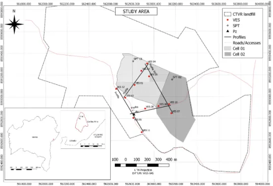
The study area, the municipality of Simões Filho, is located in the Recôncavo Basin, state of Bahia, between UTM coordinates (WGS-84S) 561800 to 564000 (longitude) and 8592400 to 8593800 (latitude). Figure 1 shows the location and general setting of the study area. The cell polygons, main accesses and position of the survey points are also illustrated in this figure.
Geologically, the study area is situated over the sediments of the São Sebastião Formation (Lower Cretaceous, Barremian-Aptian). These sediments consist of quartzose sandstones that are poorly selected, yellow-reddish in color, friable, feldspathic, and interleaved with variegate clays rich in silt (Ghignone, 1979). The area hosts the largest reservoir of groundwater in the Recôncavo Basin, the São Sebastião aquifer.
Outcrops of the São Sebastião Formation are locally observable from road cuts. Some of these outcrops are presented in Figure 2. They indicate that the sandy/silt-rich and clay-rich/silt-rich layers (centimetric to metric) are alternated in subhorizontal contact (Figs. 2A, 2B, 2C and 2D), presenting lateral (Fig. 2D) and tilted variations, occasionally, as noted by the altimetric difference of the interfaces between layers A and B identified in Figures 2C and 2D. Both photographs were taken from the same spot, in diametrically opposite directions.
THE GEOELECTRICAL METHOD
Geophysical surveys were conducted using the geoelectrical method, which aims to investigate variations in subsurface resistivity (Koefoed, 1979). This method can be broadly applied: in hydrogeology and geoenvironmental studies for investigations on the depth of the saturated zone, mapping of contamination plumes, placement of wells, determination of underground flow, monitoring of saline wedge; in geotechnical studies for mapping faults, fractures, cavities, fresh rock, thickness of the weathering mantle, to assist in the implementation of enterprises and utilities such as landfills, fuel stations, tunnels and bridges; in geology for the identification of a stratigraphic model, width of layers, mapping of lithologic contacts and geological structures.
The procedure basically consists on introducing by means of an artificial source and electrodes an electrical current in the terrain, followed by the measurement of the difference in electrical potential obtained (Telford et al., 1990). After the data collected are treated and processed, it is possible to determine subsurface resistivity. Results are expressed in the form of curves, maps, profiles and/or sections that, through their interpretation, supply information on subsurface geoelectrical behavior.
Figure 1 – Location and setting of the study area. The cell polygons and position of the survey points considered in the
present study are highlighted.
Figure 2 – Photographic records of outcrops of the São Sebastião Formation adjacent to the study area. Sandy strata are
484
GEOELECTRIC CHARACTERIZATION FOR IMPLANTATION A LANDFILLMETHODOLOGIES
Direct geological methods (surface geologic mapping and geotechnical and geological soundings) and indirect investigation through the geoelectrical method were integrated in the present study.
Geologic mapping was conducted previously and comprised field visits to observe lithologic, structural and geomorphological elements. Visual-tactile analyses, photographic records, measurements of direction and structural attitudes, and survey of hydrogeological attributes were the main procedures adopted during this stage of the study.
Soundings were conducted based on the Brazilian norm NBR 15492 (ABNT, 2007), using mechanized auger and probe. The material excavated underwent tactile and visual analysis for geologic description, following NBR 6502 (ABNT, 1995).
The geoelectrical acquisition campaign was conducted over the course of the month of November 2017, using vertical electrical sounding (VES) with Schlumberger electrode configuration. The instruments used in the field encompassed basically: a transmitting unit, which allows the supply of output tensions of the order of up to 1,000 V, associated with a milliammeter, where the injected electrical current is read, fed by a 12 V battery; and a receptor unit, millivoltmeter; as well as cables, reels and non-oxidizable electrodes that are interconnected and arranged over the surface of the terrain investigated.
The VES centers and the position of the electrodes in the geoelectrical profiles were taken using UTM coordinates with a geodesic GPS.
The data surveyed were registered in tables, treated in spreadsheets, interpolated and submitted to unidimensional and bidimensional inversion, generating apparent resistivity profiles and maps and inverted sections of true resistivity, which model the geological-geotechnical environment assessed qualitatively and quantitatively.
Unidimensional inversions were conducted using the program RESIST successively, creating an initial model with estimates on the number, width and resistivity of layers obtained per automatic inversion carried out in RES1D. In this option, the program conducts the inversion generating an equal number of layers to the number of points measured that compose the VES. An initial model for the final inversion in RESIST was constructed by grouping layers of resistivity that were close to each other, considering a lower number of layers. Bidimensional inversions were conducted using the program RES2DINV applying the least
squares method and considering the altimetric heights of the geoelectrical sounding centers.
RESULTS
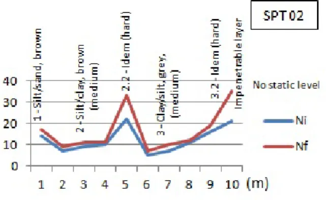
Figure 3 illustrates an example of an SPT sounding profile, which was carried out before the geoelectrical surveys. Note that the profile is located within the polygon of the future cells, in lower terrains of the study area. Moreover, it contains information on the type of material and rate of resistance to penetration, obtained by inserting a sampler through successive strikes with a hammer weighing 65 kg, in free-fall from a height of 75 cm. The graph showing resistance to penetration in function of the depth marked by the blue line corresponds to the sum of strikes needed to insert the sampler into the initial 30 cm, while the red line represents the amount for the final 30 cm.
Figure 3 – Percussion sounding (SPT 02).
The sounding demonstrated that, over the first 10 m in depth, the soil is predominantly rich in clay and silt, reaching an impenetrable substrate at approximately 11 m in depth, no reaching the water level. The mean rates of initial (Ni) and final (Nf) resistance to penetration were 12.2 and 16.4, respectively. The classification for the soil, considering state of compactness and consistency, according to NBR 6484 (ABNT, 2001), was that of soils predominantly composed of clay and silt, varying between medium and hard.
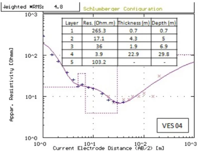
The inflexion and concavity of VES 01 (Fig. 4), conducted in the upper quotas, were turned upwards. This configuration is attributed to the possible occurrence of a clay-rich/silt-rich layer, at 8 m in depth, measuring at least 25 m in thickness. This layer was mapped in SPT, being impenetrable at 10 m in depth. In turn, VES 04 (Fig. 5), located in topographically lower portions, presented two inflexion points, which suggests the occurrence of two possible clay-rich/silt-rich layers interleaved
Figure 4 – Vertical electrical sounding (VES 01). Figure 5 – Vertical electrical sounding (VES 04).
Figure 6 – Trough samples of the Pz. Figure 7 – Vertical electrical sounding (VES 09).
with sandy/silt-rich layers. The occurrence of the clay-rich layer, at times silt-rich in nature, identified in the SPT soundings until approximately 10 m in depth, is marked by a curve descent due to the decrease in resistivity that it promotes. Moreover, it presents ascendant terminality, indicating proximity to electrically more resistant horizons, suggesting basal sandy substrate. The mean error, considering the 12 unidimensional inversions was of approximately 4.1%. The interval varied between 2.3 and 6.8%. Only one VES exceeded the error of 5%.
Water is inferred to occur between the altitude quotas of 40 to 50 m, approximately, when in sandy lithologies, based on some of the electrical soundings, such as VES 09 (Fig. 7), and information on water level at the piezometer (Pz) that was installed at 60 m in depth.
A piezometer well of 95 m (and a piezometric level of 59 m in depth) was installed considering the preliminary results of this study.
The purpose of the equipment was to optimize the local hydrostratigraphic model and serve as a background and a monitoring station for local groundwater quality. Interpretations regarding VES 09 (Fig. 7), adjacent to the piezometer, support the model of interleaved sandy and clay-rich layers with, at least, two thick layers of clay/shale (layers 4 and 7), confining the aquifer within the first 100 m in depth, as shown in Figure 6. These results can be compared to show the correlation in the stratigraphic model.
Figures 8A and 8B show the result of two of the four bidimensionally inverted geoelectrical profiles based on aligned
486
GEOELECTRIC CHARACTERIZATION FOR IMPLANTATION A LANDFILLVES profiles, comprising transects. These inversions were carried out considering the altimetric variation of surface.
Generally, geoelectrical facies with greater values, signaled in warm colors (red to orange; > 1,000 Ω.m), correspond to materials with greater predominance of silt and sand fractions. In turn, the geoelectrical facies with lower resistivity values (signaled in colors from green to blue; < 1,000 Ω m) correspond to materials that are relatively richer in dry silt and clay. These can be shales and silt-rich clays.
Profile 01, with SSW-NNE orientation, taken from the slope direction, crossing the region of Cell 01, allowed the imaging of a thick layer of clay, which occurs from near the surface to depths beyond those presently investigated. This layer was confirmed through SPT sounding profile 01 until 11 m in depth, which was the point when depth became impenetrable. Moreover, the layer is associated with silt and presented a mean rate of resistance to penetration of 14 strikes, considering the first 10 m.
Moreover, higher terrains were shown to have a relatively more resistive (Profile 03) geoelectrical signature, while terrains in lower altitudes presented a more conductive signature (Profile 04).
Two schematic sections were constructed based on the results of the uni and bidimensional inversions integrated to information from the geotechnical and geological soundings (Figs. 8C and 8D), which characterize the study area regarding interpretation. Section 01, composed of VES 03, 01, 02 and 04, cuts across approximately the center of the area of Cell 01 in the slope direction. In turn, section 02, also in the slope direction, partially cuts the polygonal area of Cell 02. Both sections indicate a confined aquifer model, with sandy to silt-rich layers interleaved with clay-rich/silt-rich layers, in subhorizontal contact, with lateral variations and discontinuities of these layers.
CONCLUSIONS
The integration of a geological-geotechnical characterization, conducted with geoelectrical geophysical surveys, and direct soundings, yielded relevant information for the planning of urban solid waste disposal cells in a landfill. Moreover, the investigation served as a background survey of the geoelectrical behavior of the area before the implementation and operation of this enterprise in the municipality of Simões Filho, metropolitan region of Salvador, Bahia. The SPT soundings indicated that the first 10 m of soil is predominantly composed of silt and clay and characterized as having medium to hard compactness, becoming impenetrable at approximately 11 m. The unidimensional inversions of VES presented mean error of 4.1% and indicated that the clay-rich
layer in the SPT soundings extends to depths of the order of 20 to 30 m in the area of the cell polygons. The inversions also showed that the stratigraphic pattern in the first 100 m is of alternated clay-rich and sandy to silt-rich layers, with at least two thick layers of clay/shale. The bidimensional inversions reached approximately 35 m and presented mean error of 5.7%. They presented contrasting electrical resistivity values, of the order of tens to thousands of Ohm.m, varying laterally and vertically. Lower electrical resistivity values predominated the lower terrains, while relatively higher terrains showed predominance of higher values. The facies of lower values (< 1,000 Ohm.m) were attributed to the occurrence of a silt to clay fraction, while higher values (> 1,000 Ohm.m) were attributed to a silt to sand fraction. The piezometer profile of 95 m installed confirmed and optimized the model of interleaved sandy to clay-rich layers. Thus, the integration of the data and results indicate a confined aquifer model, composed of successive sandy to clay-rich layers, with occasional occurrence of silt, interleaved in subhorizontal contact, with lateral variation and occurrence of water between quotas of 40 to 50 m in height, when in sandy fractions. Expansive properties of the clay layer subjacent to the cell polygons should be analyzed.
ACKNOWLEDGMENTS
The authors thank NEHMA/UFBA for infrastructure, CNPq for financed research scholarship and the Professors Olivar Lima, Sandro Machado and Cristovaldo Santos for their contributions and suggestions.
REFERENCES
ABNT – Associação Brasileira de Normas Técnicas. 1995. Rochas e solos – Terminologia. (Rocks and soils – Terminology). Rio de Janeiro, RJ, Brazil. 18 pp. NBR 6502. [In Portuguese].
ABNT – Associação Brasileira de Normas Técnicas. 2001. Solo – Sondagens de simples reconhecimentos com SPT – Método de ensaio. (Soil – Standard penetration test - SPT- Soil sampling and classification – Test method). Rio de Janeiro, RJ, Brazil. 17 pp. NBR 6484. [In Portuguese].
ABNT – Associação Brasileira de Normas Técnicas. 2007. Sondagem de reconhecimento para fins de qualidade ambiental – Procedimento. (Borings in order to analysing environmental quality – Procedure). Rio de Janeiro, RJ, Brazil. 31 pp. NBR 15492. [In Portuguese].
BRASIL. 2010. Lei nº 12.305 de 2 de agosto de 2010. Institui a Política Nacional de Resíduos Sólidos. Brasília, DF, Brazil.
Figure 8 – Bidimensionally inverted profiles and interpretative geological section based on the aligned VES profiles, corresponding to cells 01 (A and C) and 02 (B and D).
488
GEOELECTRIC CHARACTERIZATION FOR IMPLANTATION A LANDFILL CAVALCANTI SS, SATO HK & LIMA OAL. 2001. Geofísica elétrica na caracterização da hidrologia subterrânea na região do Aterro Metropolitano Centro, Salvador, Bahia. Revista Brasileira de Geofísica, 19(2): 155-168.ELIS VR & ZUQUETTE LV. 2002. Caracterização geofísica de áreas utilizadas para disposição de resíduos sólidos urbanos. Revista Brasileira de Geociências, 32(1): 119–134.
FARHANA SS, WEEKES JS, MELIKECHI N, HOSSAIN S, FLUMAN DA & RANA MM. 2016. In-situ moisture content measurement of fresh municipal solid waste by wenner resistivity method. Journal of Solid Waste Technology and Management, 42(3): 184–189.
FOTI S. 2013. Combined use of geophysical methods in site characterization. In: COUTINHO RQ & MAYNE PW (Eds.). Geotechnical and Geophysical Site Characterization 4. Proceedings ISC-4: the Fourth International Conference on Site Characterization. Pernambuco, Brazil. Taylor & Francis Group, London, v. 1 p. 43-61.
GHIGNONE JI. 1979. Geologia dos Sedimentos Fanerozóicos do Estado da Bahia. In: Geologia e Recursos Minerais do Estado da Bahia, Textos Básicos. SME/CPM: 23–117, Salvador.
GRELLIER S, REDDY KR, GANGATHULASI J, ADIB R & PETERS CC. 2007. Correlation between electrical resistivity and moisture content of municipal solid waste in bioreactor landfill. Geotechnical Special Publication, 163: 1-14.
KOEFOED O. 1979. Geosounding principles: Resistivity sounding measurements. Elsevier, Amsterdam. 276 pp.
MOREIRA CA, BRAGA ACO & HANSEN MAF. 2011. Estimativa do tempo de produção de chorume em aterro controlado por meio de medidas de resistividade elétrica. Revista Brasileira de Geociências, 41(3): 549–557. PORCIÚNCULA RJ & LIMA OAL. 2012. Geoelectric evaluation of subsurface contamination at a gas and service station, Alagoinhas, BA, Brazil. Revista Brasileira de Geofísica, 30(2): 201-212.
TELFORD WM, GELDART LP & SHERIFF RE. 1990. Applied Geophysics. Cambridge University Press, Cambridge, 770 pp.
Recebido em 30 de outubro de 2019 / Aceito em 3 de janeiro de 2020 Received on October 30, 2019 / Accepted on January 3, 2020