Journal of Integrated Coastal Zone Management / Revista de Gestão Costeira Integrada 20(1):27-48 (2020) http://www.aprh.pt/rgci/pdf/rgci-n213_Oliveira.pdf | DOI:10.5894/rgci-n213
The evolution of the European framework for coastal
management, linked to the new environmental challenges.
The Portuguese case
Sónia Oliveira
@, Delminda Moura, Tomasz Boski
@ Corresponding author: [email protected]
University of Algarve, Centre for Marine and Environmental Research (CIMA), Portugal.
ABSTRACT: The sharing of space by various human activities leading to social conflicts and threats to ecosystems, alongside increased awareness of the threats to coastal zones has created the need to legislate on coastal planning and integrated management by developing international guidelines. A new management challenge has emerged due to climate change that had not previously been considered in legislation or policies. Therefore, the European tools and frameworks applied in Portugal, their implementation and effectiveness will be analysed. Extensive bibliographic data was analysed including EU directives and policies, and Portuguese governmental documents from national to a municipal level. We found that all the European Union guidelines and frameworks are being implemented in the Portuguese Governmental planning and are very well substantiated, whereas the base of all land management instruments (IGT), have a questionable implementation, mainly due to the number of entities involved and the long implementation process.
Keywords: Integrated Coastal Management; Europe, Portugal, Directives, Climate Changes.
RESUMO: A partilha de espaço por várias atividades humanas que levam a conflitos sociais e ameaças aos ecossistemas, juntamente com o aumento da consciencialização sobre as ameaças às zonas costeiras, criou a necessidade de legislar o planeamento costeiro e a gestão integrada, desenvolvendo diretrizes internacionais. Um novo desafio de gestão surgiu devido às alterações climáticas, que não haviam sido consideradas anteriormente na legislação ou nas políticas. Por conseguinte, serão analisadas as ferramentas e quadros europeus aplicados em Portugal, a sua implementação e eficácia. A base bibliográfica estudada foi extensa, incluindo diretivas e políticas da UE e documentos governamentais portugueses, de nível nacional a municipal. Evidenciámos que as diretrizes e quadros de referência da União Europeia estão a ser implementados no planeamento do Governo Português e são muito bem substanciadas, enquanto a base de todos os instrumentos de gestão territorial (IGT) tem uma implementação questionável, principalmente devido ao número de entidades envolvidas e o longo processo de implementação.
Palavras Chave: Gestão Costeira Integrada; Europa, Portugal, Diretivas, Alterações climáticas.
1. INTRODUCTION
Coasts worldwide extend for 20% of the Earth’s surface and half of the world’s population live within 60 km of the coastline (Nicholls, 2007; Collet and Engelbert, 2013).
Several kinds of classification have been used to group coastal areas according to their morphostructural characteristics or genesis (e.g., Suess, 1888; Johnson, 1919; Shepard, 1973; Inman and Nordstrom, 1971; Finkl, 2004). For instance, aiming to develop a comprehensive coastal classification, Finkl (2004) proposed an approach based on morphological units subdivided in terms of litholoy of the substratum, age, geodynamics, climate, relief and erosional-depositional processes and forms. Littoral morphology and evolution depend on the nature of the bio-physical support, sedimentary balance, marine climate and exposure to waves, sea level changes, inherited morphology and the time during which littoral zones are being acted upon by morphodynamic agents. Due to climate change, the increase in mean sea level (MSL) is expected to accelerate, making the management of the growing occupation of the coast a priority. Governments facing with MSL rise have recognized the urgency in promoting integrated coastal management (Antunes and Taborda, 2009; IPCC, 2013).
The European Commission describes coastal zones as attractive, productive areas with diverse valuable habitats and ecosystem services (European Commission, 2013a). Coastal zones support a diverse range of related industries such as fisheries, tourism and oil industries that in turn provide enormous economic interest (Cummins
et al., 2003). Densely populated coastal regions due to
excessive anthropogenic pressure can also be dynamic environments posing hazards to ecosystems, human life, and the economy by imposing stress on finite coastal systems and resources (Rabenold, 2013; Cummins
et al., 2003). Therefore, an integrated management of
all actions that share the coastal area is necessary and imperative to safeguard the sustainable development and the maintenance of ecosystem services, reinforcing the need to legislate on coastal planning and integrated management.
For coastal management, the European Commission defines as coastal area/region: i) a region with a sea border (382 EU regions meet this criterion); ii) a region where more than half of the population is living less than 50 km from the sea (63 further regions satisfy this criterion); and, iii) the Hamburg region, which was added to the list of EU coastal regions due to its strong maritime influence. Therefore, in 2013, coastal regions accounted for 40% of European Union territory, with a total of 446 coastal regions in 23-member states (including the
United Kingdom), being considered the most desirable places to live and work in, and being in high demand for leisure activities (Rabenold, 2013).
1.1 Ecology and Human Occupation
The dense population of coastal regions and over exploitation of the sea can damage ecosystems, leading to the limitation of public access to the foreshore, erosion, siltation and, in the worst cases, render coastlines more vulnerable to storms and natural disasters (Nicholls, 2007; Cummins et al., 2003). By 2013, 58.1% of fish stocks were being fully exploited, 31.4% depleted, overexploited or recovering, with the remaining 10.5% being underexploited or moderately exploited (FAO, 2016). The development of engineering structures and human housing along the coastline restricts the ability of inter-tidal habitats to move landward as sea levels rise. Water quality is affected by pollution from ships, coastal industries and from land-based sources such as agriculture and industries that release waste into rivers (GESAMP, 2001). The explosive growth of the population in the coastal zone, partly due to tourism, has increased the pressures on the coast, especially along the French, Spanish, and Portuguese coasts, and the southern coast of the United Kingdom (RIKZ, 2004).
Aiming to systematise the planning strategies, due to common problems, Connolly et al. (2001) categorised coastal zones taking into account the main processes that contribute to their evolution, based on the Irish example as follows: i) coastal development, pressure imposed by social and economic driving forces such as urban expansion, retirement, second homes and tourism industry; ii) coastal agriculture, one of the biggest sources of pollution which has led to a reduction in semi-natural habitats and to a decrease in biological diversity (McGarrigle, 1999); iii) coastal erosion and floods, pressure imposed by high demographic numbers and infrastructures inducing a greater erosion of the coast by the retreat of cliffs and the breakup of the sediment budget (see examples in Teixeira, 2014; Kwasi, 2014); iv) tourism and recreational use, increase in tourist numbers has been shown to threaten areas of high ecological and resource value in coastal marine environment; v) coastal industry, ports and harbours, releasing high volumes of chemicals in the water, increasing the damage to several habitats; vi) fishing and aquaculture industry, sustainability of fisheries has become questionable; vii) water quality, direct discharge of urban wastewater, domestic and industrial sewage into coastal waters via drainage networks and aquifers; and, viii) offshore resources, that may lead to the loss of landscape and seascape as a result of accidental spills (see example in Cummins et al., 2003).
Most of the above-mentioned impacts occur worldwide in coastal areas, reinforcing the need to achieve an effective, integrated coastal management. Therefore, international guidelines on integrated coastal management need to be further improved, despite the efforts already made.
1.2 Purpose and organisation
This work aims to review the European tools and frameworks on Integrated Coastal Management (ICM) and evaluate their implementation and effectiveness, using Portugal as a case study.
First, European guidelines and management tools to achieve integrated coastal management are analysed, followed by an assessment of their adaption to the impact of climate change on coastal systems. Later sections assess the Portuguese legal and administrative settings and how Portugal is dealing with EU demands for achieving good integrated coastal management. For organisational purposes and better understanding, the Portuguese acronyms are presented throughout the manuscript in italic.
The EU produces a range of official documents to implement and support policies and legislation. Obligations for the Member States are introduced through legislative documents while others are set with a non-binding effect. According to Qiu and Jones (2013) the EU Law can be organized in “primary” and “secondary” with treaties establishing the basic rules for decisions and actions that must be included in secondary legislation such as regulations, directives and decisions. To aid in the better understanding of this manuscript, a short description of some of these documents is made bellow (EU Monitor, 2020):
i) Treaty is a legal binding agreement, subject to international law, between countries on any given subject.
ii) Regulation is a binding legislative act applied entirety across the EU.
iii) Directive is a legislative binding act that establishes a set of objectives which all member states must fulfil, but each state can decide how.
iv) Decision is binding act in its entirety, unless explicitly stated otherwise.
v) Act is an instrument in writing to verify a legislative act being used sometimes as foundation for a treaty. vi) Protocol is annexed to a treaty and stipulates detailed measures or actions on a specific part of that treaty.
vii) Green Paper is a document published to stimulate
discussion on given topics at European level and may serve as a basis for later legislative proposals.
viii) Communication is a policy document with no legal effect, a way for the European Commission to voice their opinion on an issue.
ix) Recommendation does not impose any legal obligation on those to whom it is addressed. It allows the institutions to make their views known and to suggest a line of action.
x) Guidelines are non-binding acts that set out a framework for future acts in a policy area.
xi) Reports are issued by the European Commission to report and assess current policies. A report may provide a basis for policy development.
2. EUROPEAN GUIDELINES AND TOOLS
TO ACHIEVE INTEGRATED COASTAL
MANAGEMENT
The awareness established in the scientific community and among high ranking government officials about coastal issues has allowed for the discussion and creation of several necessary international policies, some of which have already been referred to in previous sections. The earliest efforts in this regard were made by developed coastal nations, as coastal zones became degraded due to inappropriate development and poor planning (Vallega, 1996; Cicin-San and Knecht, 1998).
Within Europe, the first implementation of coastal policies was done in 1973, with the conclusion of the Council of Europe Committee of Ministers Resolution on the Protection of the Coastline. This resolution officially stated that Europe’s coastlines were at risk and that member states should join forces to protect them. To reduce or eliminate problems resulting from densely populated coastal regions and overexploitation of the sea and coastal zones, the now widely recognised concept of Integrated Coastal Management (ICM) was consolidated. The ICM concept was an attempt to resolve the increasing anthropogenic pressures on coastal resources, prompting countries internationally to take an interest in the quality and management of their coastal environments. Previously known as Integrated Coastal Zone Management (ICZM), within Europe the concept was defined in 1976 and ratified by the Council of the European Union in 2010 (Millemann, 1995; Council of the European Union, 2008).
In the literature, several definitions and explanations can be found for the ICM concept, but the underlying principle is always the same: manage the coast taking into consideration all the different components and
stakeholders. The definition of ICM varies according to the different authors, with some based on the use while others place emphasis on processes (Knecht and Archer, 1993; Olsen et al., 1999; Olsen and Nickerson, 2003; Cicin-Sain and Knecht,1998; Ehler, 2003). All conclude that integrated coastal management is an extremely complex process concerning the balance between the resilience of natural ecosystems and the needs of human society (Cicin-Sain and Knecht, 2000).
The concept of ICM was embraced by nations around the world as a central concept in the management of coastal zones and ocean areas as one of the principal recommendations of Agenda 21, which was adopted at the United Nations Conference on Environment and Development (UNCED) – the Earth Summit – in Rio de Janeiro, 1992. It gave both international prominence and political legitimacy to the concepts of ICM and sustainable development. Coastal states were required to provide an integrated policy and decision-making process, including all involved sectors, to promote compatibility and a balance of uses in the coastal area to guaranty the present and future generation’s needs (Robinson, 1992). The main principals of ICM as identified by the EU include: a wide-ranging view of inter-related problems; decision making based on good data and information; working with natural forces; involving all stakeholders and all relevant parts of the administration; and, use of a range of instruments (laws, plans, economic instruments, and information campaigns). This will contribute to ensure coherence between policies, plans and programmes, and the effective nesting and implementation of plans and programmes at different scales of intervention. The overall result should be clear for policy and decision-making in order to facilitate the sustainable development of maritime economies and enhance the livelihoods of coastal communities (European Commission, 2007b). In Agenda 21 of 1992, not only the ICM was defined but also the capacity building concept. This concept involves human resource development, the creation of coastal organisations and promotion of an overall policy environment to generate appropriate responses to emerging needs (UNDP/UNDOALOS, 1994). Agenda 21 also aimed to create infrastructures, encourage people capacitation, produce training materials (i.e. texts, notes, cases), and work with academics to aid professionals in spreading the regional and global importance of protecting the coasts (Cicin-Sain et al., 2000). This goal also imposed changes in education, research centres and governmental councils.
Before the acceptance of the concept and guidelines imposed by Agenda 21, different disciplines concerned with the study of oceans and coasts operated independently,
using different languages and different underlying worldviews and structures (Cicin-Sain et al., 2000). The study and analysis of oceans and coasts and government policies were oriented around single disciplines and single sectors. For example, geology was applied to coastal problems such as beach and cliff erosion, sedimentary balance between fluvial input and alongshore drift; physical oceanography was used to determine the magnitude and direction of the ocean currents and waves that affect the coastal morphodynamic processes, pollutant dispersion and ecosystems and, social sciences were applied to determine the behaviour of coastal residents and user groups. The study of a region was independent according to each scientific theme but, with the ICM, the frontiers between disciplines are supposed to be breached and the evaluation of an area embraces all disciplines and the interaction between them. Integrated coastal management, in effect, represents a new paradigm of management for the managers, and a new way of thinking and educating for the scientists (Cicin-Sain et al., 1995).
In parallel to the previous concepts and developments, between 1973 and 1981, the First European Community action programmes on the environment were launched with special care concerning matters of ecological management in coastal areas. In 1975, the Wetlands Convention, also called the Ramsar Convention, was enforced, an intergovernmental treaty adopted in 1971 that represents the first of the global treaties on conservation. Also, the Birds Directive 79/409/EEC adopted in 1979, is the oldest piece of EU legislation on the environment, that emphasises the protection of habitats for endangered and migratory species and that was amended in 2009 becoming the Directive 2009/147/EC.
The First European Community action programmes also led to the European Coastal Charter, which was prepared by the Conference of Peripheral Maritime Regions in Europe and led in 1982 to the Resolution of the European Parliament (European Communities, 1982). Both underlined the need for integrated planning of coastal areas and therefore, in 1983, the European Regional/ Spatial Planning Charter was adopted by the Conference of Ministers Responsible for Spatial/Regional Planning – CEMAT (Council of Europe, Committee of Ministers, 1984). The CEMAT did further work establishing the Model Law on Sustainable Management and the European Code of Conduct for Coastal Zones (Council of Europe, 2000). Hence, establishing the general management principles to achieve sustainable development and preservation of environmental values in coastal areas.
In 1985 the Environmental Impact Assessment (EIA) Directive was adopted by the European Economic Community, which applies to a wide range of public and
private projects, which are defined in Annexes I and II of the same directive (85/337/EEC). The projects in Annex 1 have mandatory guidelines related to infrastructures, defining, for example, structures for hazardous waste disposal and that airports must have a basic runway length ≥ 2100 m. For projects listed in Annex II, the national authorities must use a screening procedure and decide whether an EIA is needed. The directive was amended three times, in 1997, 2003 and in 2009, the latter due to the increasing amount of carbon dioxide added to the atmosphere by anthropogenic emissions which introduced the need to include this variable in the directives, adding projects related to its transport, capture and storage.
Between 1992 and 1994 the Council Directive 92/43/ EEC was adopted. It concerns the conservation of natural habitats and of wild fauna and flora also known as the Habitats Directive – SCI (Council of the European Union, 1992). Habitat loss and degradation are the most serious threats to the conservation of wild birds and landscapes. Accordingly, the directive places great emphasis on the protection of habitats for endangered and migratory species. It established a network of Special Protection Areas (SPAs) including all of the most suitable territories for these species. In the European Union, under the Birds Directive, the Important Bird and Biodiversity Areas (IBAs) are identified through the application of international scientific criteria and constitute a network of sites essential for the conservation of birds with unfavourable conservation status, which were used as the basis to designate SPAs. Since 1994, all SPAs are also included in the Natura 2000 ecological network, set up under the Habitats Directive 92/43/EEC.
In parallel to the previous concepts and developments, the Ecosystem Approach (EsA) emerged, initially in the late 1980s and early 1990s as a topic of discussion in research and policy communities working on the management of biodiversity and natural resources (Hartje et al., 2003). It aimed to manage the ecosystems, based on the multiple functions that they perform and the multiple uses that they may have, and to optimise the use of an ecosystem without damaging it (Haines-Young and Potschin, 2011). The EsA is transversal to various policies, including ICM and Marine Spatial Planning (MSP). The ICM depends on the EsA’s approach to guaranty a broad‐scale approach in research and management that considers people’s behaviour and their relationship to the environment.
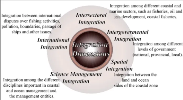
Several efforts have been made to develop international guidelines and protocols on integrated coastal management that guarantee the best conduct in coastal areas. Cicin-Sain and Knecht (1998), assume that the
central aspect of ICM is integration and that several dimensions of integration are involved in ICM (Fig. 1).
Figure 1. Conceptual scheme according to Cicin-Sain and Knecht 1998. The integrated management along the dimensions referred to in Figure 1 is difficult to achieve due to the involvement of oceans, coasts and international divergent sectoral government agencies, and governance at different levels, each with their own interests, mandates, and perspectives. To aid in achieving integrated management, Cicin-Sain and Knecht (1998) and Cicin-Sain et al. (2000) emphasise the importance of having incentives that promote continued collaboration among ICM entities. It is also important to provide training and education programmes based on coastal and ocean activities, uses, natural systems, and physical processes. This way developing the appropriate mind sets and skills that coastal managers and the general population need (Vallega, 1999), while also providing technical information about sustainable coastal zone management, and stimulating a broad debate among the various stakeholders. This would hopefully lead to a consensus regarding the measures necessary to stimulate Integrated Coastal Management in Europe (Fig. 2). This resulted in two documents; the first was a Communication on “Integrated Coastal Zone Management: A Strategy for Europe” in which six overarching ideas for ICZM were proposed by the European Parliament. This document recommended a wide-ranging perspective, building on an understanding of specific conditions, working with natural processes, using participatory processes, ensuring the support and involvement of all relevant administrative agencies, and using a combination of instruments and approaches (European Commission, 2000a). The second document was a proposal for European Parliament and Council Recommendation concerning the implementation
of Integrated Coastal Zone Management in Europe (European Parliament, Council of the European Union, 2002). The recommendation defines the essential characteristics of ICZM focussing on integration across sectors and knowledge-based approach (European Commission, 2000b).
In 2000, the EU Water Framework Directive (WFD), establishing a framework for the community action in the field of water policy, entered into force (European Parliament, Council of the European Union, 2000). Some amendments have been introduced into the Directive since 2000 but the Directive still focuses on 8 key aspects of the implementation: i) Coordination in international river basin districts; ii) Risk assessment of surface water bodies; iii) Groundwater management; iv) Artificial and modified water bodies management; v) Establish a value for waters; vi) Monitoring programmes; vii) Establish a common scale for Europe’s waters; and, viii) Reducing dangerous chemicals in Europe’s waters. Although these principles do not directly concern the coastal zones, the quality of coastal habitats are related to the quality of the water coming from the drainage basins and adjacent aquifers. Therefore, they are very important to consider. Taking in consideration the WFD, in 2001 the Strategic Environmental Assessment (SEA) was enforced and applied to a wide range of public plans and programmes (European Parliament, Council of the European Union, 2001). It is mandatory for programmes and plans that (i) apply to agriculture, forestry, fisheries, energy, industry, transport, waste/water management, telecommunications, tourism, town and country planning or land use; and (ii) have been determined to require
an assessment under the Habitats Directive; therefore setting the framework for future development consent of projects in the EIA Directive.
Between 2007 and 2008 a green paper was adopted in Europe, launching ‘An integrated maritime policy for the European Union’ (European Commission, 2007a). This policy aims to educate and enhance Europe’s knowledge and awareness of maritime affairs, development and sustainable growth and the sustainable use of oceans and seas, stressing the importance of coastal regions. Moreover, the European Union adopted the Marine Strategy Framework Directive (MSFD) which aims to protect the marine environment and natural resources and creates a framework for the sustainable use of marine waters.
In 2011, the Biodiversity Strategy was adopted by the EU establishing 6 targets and 20 actions to help stop global biodiversity loss by 2020. This reflected the commitments taken by the EU in 2010, within the International Convention on Biological Diversity. Furthermore, in 2013 an additional Proposal Directive of the European Parliament and of the Council established a Framework for Maritime Spatial Planning and Integrated Coastal Management to promote the sustainable growth of maritime and coastal activities and the sustainable
use of coastal and marine resources. The Proposal Directive of the European Parliament and of the Council requires the mapping of all human activities at sea, identification of future spatial development, spatial plans and coordination of relevant policies in integrated coastal management strategies. It employed an approach that respects the limits of ecosystems, including the assessment of plans and strategies in accordance with the provisions of Directive SEA on strategic environmental assessment, economic activities and hazards in coastal areas that will improve interaction between land- and sea-based activities. This would also help the regional implementation of several other EU policies relevant for marine and coastal areas, such as Marine Strategy Framework Directive, the Water Framework Directive, the Natura network, Habitats Directives and the Biodiversity Strategy.
In addition to emitting guidelines and frameworks, the EU financially supports the implementation of integrated management projects, depending on the nature of the project. Funding possibilities are vast under the structural funds and the cohesion policy of the EU. Some of the funding tools are the EU’s funding instrument for the environment (LIFE+), the European Agricultural Fund for Rural Development (EAFRD), the Development Cooperation Instrument and the Intelligent Energy programmes. To aid in the distribution of information to the general and scientific population, two information platforms were also created; OURCOAST and Coastal Wikipedia. The OURCOAST database provides case-studies and best-practice examples to support ICZM implementation while the Coastal Wikipedia gathers coastal management knowledge, research and results of the EU co-funded research project ENCORA.
Coasts worldwide differ due to physical, social, economic, biological and cultural factors therefore there is no one standard for implementing an ICM solution. On the contrary, ICM must be adapted to each region. For instance, the ICZM Protocol on Integrated Coastal Zone Management in the Mediterranean was used to achieve a dynamic process for the sustainable management and use of coastal zones. To achieve this, the fragility of coastal ecosystems and landscapes, the diversity of activities, their interactions, uses and their impact on both the marine and land parts had to be taken into account (UNEP/MAP/PAP, 2001; UNEP/MAP/ PAP, 2008). Other strategies to maintain and guarantee integrated management are to create working groups across Europe with the main goal to access and guarantee the equilibrium of the regional ecosystem. For example, in 2010, a common working group was created between the Baltic Marine Environment Protection Commission (HELCOM) and Visions and Strategies around the Baltic
Sea (VASAB), to cooperate in the ICZM and Maritime Spatial Planning of the Baltic Sea.
In general, the implementation of an ICM policy, programme or project in a region requires several integrative stages. Olsen et al. (1998) breaks these several stages into five steps: (i) identification of issues; (ii) plan preparation; (iii) formal adoption and funding; (iv) implementation; and, (v) monitoring and evaluation. The interactive nature of the ICM process requires feedback among the stages, which may alter the sequence or require repetition of some stages (Cummins
et al., 2003). The evaluation of the regional and country
management plans is an excellent strategy to maintain the care of the area and guarantee the implementation of the directives, protocols and laws of the EU that will be discussed further on in this work using Portugal as a case study.
3. INTEGRATED COASTAL
MANAGEMENT AND CLIMATE CHANGE
IMPACTS ON COASTAL SYSTEMS
Climate change is a key threatening process to biodiversity and natural systems evolution (Krockenberger et al., 2003; Gonzalez et al., 2010; Sommer et al., 2010) and it will exacerbate many already existing threats (Auld and Keith, 2009; Tanner-McAllister et al., 2017). Climate change may cause serious impacts on human and environmental systems. This issue for which scientific evidence exists challenges the world (IPCC, 2014). It is reported that the changing climate may result in increasingly extreme events worldwide, leading to heavier socioeconomic damages (IPCC, 2012; Rummukainen, 2012). This issue has been receiving more attention from both the public and, especially, governments, and researchers have been devoted to exploring effective measures to mitigate adverse consequences (Yuan et al., 2017).
The 2015 United Nations Climate Change Conference, held in Paris, negotiated the Paris Agreement, a global plan for the reduction of the effects of climate change, with parties setting the limit of temperature increase to be below 2ºC, aspiring 1.5ºC (UNFCCC, 2015
)
. In 2016, 174 countries began adopting it within their own legal systems aiming to limit global warming to below 2 °C. At the European level, developments started with the most prominent document being the EU Strategy for Adapting to Climate Change by the Commission Communication COM (2013) 216 (European Commission, 2013b). This instrument gave new impetus to the adaptation dimension in the field of climate policy and encouraged member states which did not yet have a climate change adaptation policy to develop one or, as in the case ofPortugal, to deepen existing policies and move from a more analytical dimension of the problem towards a more operational dimension and the application of adaptation measures. Also, EU Regulation 525/2013 reinforced reporting obligations on climate change related issues and introduced, for the first time, the obligation to systematise and report on adaptation-related information to all member states, both in terms of internal adaptation efforts and in terms of international support to the third countries (Article 15 and 16 of European Parliament, Council of the European Union, 2013). Finally, reference should be made to an effort to systematise and make available information relevant to the development of adaptation policies by the European Environment Agency in the European Climate Adaptation Platform/Climate-Adapt (http://climate-adapt.eea.europa.eu/) which, since 2012, has collected and made available information on each member state as well as results of relevant European research projects per theme.
4. THE PORTUGUESE CASE
Portugal is the westernmost country of mainland Europe, located on the Iberian Peninsula in southwestern Europe (Fig. 3.A). From an administrative point of view, the country consists of 18 districts, further divided into 308 municipalities. Portugal also has two autonomous regions, Azores, and Madeira, with their own regional governments. The Portuguese mainland is bordered to the west and south by the Atlantic Ocean and to the east and north by Spain. The coastline stretches between the Minho and Guadiana estuaries along approximately 987 km with a morphologically diverse coast. Portugal operates in a highly centralised way, organised in Nomenclature of Territorial Units for Statistics (NUTS) in accordance with EU regulation (EU statistical office- Eurostat), which implies that, in practice, the municipalities have relatively limited responsibilities. NUTS are hierarchically sub-divided into three levels according to their demographic dimension (in Portugal: 3 NUTS I, 7 Nuts II and 25 NUTS III).
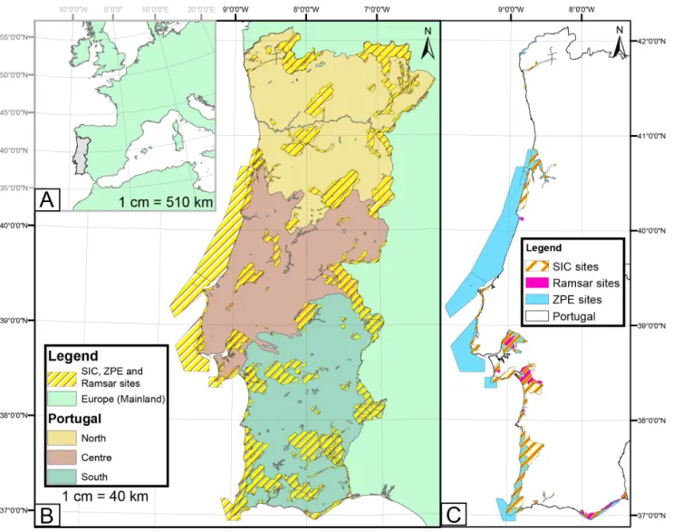
Portugal has 13 Natural Parks of which 5 are located on the coast (Litoral Norte; Sintra-Cascais; Arrábida; Sudoeste Alentejano e Costa Vicentina; and Ria Formosa). In Portugal there are also 165 sites (50895 km2) in the Natura 2000 network
composed of sites under the Habitats Directive (SCIs), the Birds Directive (SPAs) and the Ramsar Convention, according to which they were divided by the Portuguese state into Special Protection Zone (ZPE), Sites of Community Importance and National List (SIC) and Ramsar sites (Fig.3.B.). Most of them overlap and more than 50% of the national sites have at least part of their
area, if not the entire area, within the coastal zone. This reflects the biodiversity and the need for conservation of the Portuguese coasts.
In continental Portugal, the recent and abrupt growth in activity related to recreation and economic activities, including increasing marine and coastal industries, live and non-live resource exploitation and aquaculture, led to the cluttered expansion of the urban centres and scattered construction, which contributes to the mischaracterisation and devaluation of the landscape (APA, 2016). About 60% of the population inhabits the coastal zone near larger cities but it rises to 80% in the summer months (European Commission, 2016). Considering data available from the Database of Contemporary Portugal (PORDATA- https://www.pordata.pt/), in 2018, nationally there was a total of 10 283 800 inhabitants and 3 604 407 buildings. The increased occupation of the coast and the diversity of activities often leads to incompatibility with the natural dynamics. This results in numerous and increasingly frequent situations of conflict, leading to contradictory intervention strategies, increased erosion, decreased water quality and degradation of ecosystems. Considering all the impacts categorised by Connolly
et al. (2001), Portugal is a good case study to evaluate
integrated coastal management and the efforts taken to establish the international guidelines.
4.1 Coastal legal and administrative framework
The threat caused by human pressure, agricultural intensification, industrialisation, high urban growth, increased tourism, unsustainable exploitation of resources and the lack of investment in literacy and preservation led to the need to protect the coast and, therefore, regulated standards arose to legally protect, plan and develop the entire system.
Close to a hundred entities (6 ministries, 11 secretaries of state, 27 institutes and general directors and 51 municipalities) currently decide about what is happening on the coast, including the Portuguese Environment Agency (APA), the Port Administrations, the Institute for Nature Conservation and Forests (ICNF), the Administration of Hydrographic Regions (ARH), and the National Commission of the National Ecological Reserve (CNREN) (Schmidt et al., 2014).
The European Regional/Spatial Planning Charter that presented and suggested criteria for the guidance of planning and regional planning to improve the quality of life, effective distribution of activities and protect the environment was adopted by Portugal in 1990.
In 1995, the combination of the Coastal Zone Management Plans (POOCs), public water reservoirs
(POA, Water Supply Management Plans) and of protected areas (POAP, Protected Area Management Plans), into a special set of plans called Special Plans of Spatial Planning (PEOTs) was approved, aiming for a more integrated management.
By the end of the 1990s, almost all municipalities in the country either had, or were developing, a municipal director plan and were approving regional spatial plans. The first Framework Act of Land Use, Spatial Planning and Urbanism Public Policy (Lei de Bases Gerais
da Política Pública de Solos, de Ordenamento do Território e de Urbanismo - LBPPSOTU) appeared in
1998, indicating the duty to ensure proper organisation and sustainable use of national space, valuing the economic, social and cultural level (Law No. 48/98). The territorial management system was organised into three distinct levels (national, regional and municipal) being adjusted in 2007 with the simplification of plans approvals and the addition to the PEOTs of the special
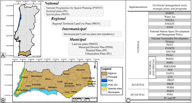
plan for estuaries, POE - Estuary Management Plans (Portuguese Law No. 54/2007). In 2014, Portuguese Law No. 31/2014 cancelled the previous legislation, putting in place a new law on general grounds of the LBPPSOTU. This new basic law relies on an inclusion of environmental policies on spatial and urban planning, an incentive for inter-municipal cooperation and the intention to simplify and streamline the operation of the system planning. The approach to planning via Territorial Management Tools (IGT) is divided into four areas (national, regional, intermunicipal and municipal) and is indicated as IGT plans and planning programmes (Fig. 4.C.). The plans set out the options and concrete actions for the planning and organisation of the territory, also defining land use, while the planning programmes set out the strategic framework for territorial development, with programme guidelines defining the spatial distribution of national policies to consider at each level of planning.
Figure 3. Location of the study case. A) Portugal’s location within Europe. B) Portugal with natural parks, SIC, ZPE and Ramsar sites. C) SIC, ZPE and Ramsar sites at the coast.
Several tools and baselines were created in Portugal such as the National Programmes for Spatial Planning (PNPOT), a territorial development tool of strategic nature which sets out the main options relevant to the organisation of the national territory. It constitutes the reference framework to consider in the development of other land management instruments and is an instrument of cooperation with other member states for the territorial organisation of the European Union (Portuguese Law No. 58/2007).
The growth in coastal zones led to the creation of the National Strategy for Sustainable Development for 2005/15, which consists of a coordinated set of actions that sets a 12-year horizon to ensure rapid and vigorous economic growth, greater social cohesion, and a high and increasing level of environmental protection. Furthermore, the National Strategic Tourism Plan (PENT), was revised by the Resolution of the Council of Ministers No. 24/2013, and aimed, by 2015, to ensure a sustainable increase in the contribution of tourism to the national gross domestic product (GDP), increase skilled employment and accelerate the growth of the sector. The National Strategy for Integrated Coastal Zone Management (ENGIZC), approved by Council of Ministers Resolution No. 82/2009, complies with Recommendation 2002/413 / EC of the European Parliament, which lays down the general principles and options for an Integrated Strategy for Integrated Coastal Zone Management in Europe. The new Strategy should incorporate the Marine Strategy Framework Directive (MSFD) and new benchmarks addressing the need to ensure a clear articulation with the planning and management of maritime space and with the conservation of the marine environment. ENGIZC brought some national clarity to physical aspects, not only for planning policies, but also for coastal zone management and planning. These are defined as: Littoral, Coastal Zone, Coastal Border, and Coastline. ENGIZC established as vision to be achieved by 2029 a developed and sustainable coastal zone, based on a systemic approach and valorisation of its resources and identity values, supported by scientific knowledge and managed according to an integrative model (Resolution of Council of Ministers No. 82/2009).
The national maritime space extends from the baselines to the outer limit of the continental shelf beyond 200 nautical miles; a large area that must be managed. Therefore, several strategies and plans must be in place to ensure its safety. The National Strategy for the Sea (ENM) - Council of Ministers Resolution No.163/2006 of 12 December, was reviewed and published for the period of 2013-2020. Its aim is to ensure better use of the
resources of the ocean and coastal zones, promoting the economic and social development in a sustainable and environmentally friendly manner, through coordinated efficient, accountable and committed organisation, that actively contributes to International Oceans Agenda (DGPM, 2013). Projects identified in the 2008 National Strategy for the Sea action plan included the establishment of a National Network of Marine Protected Areas (e.g. the Important Bird and Biodiversity Areas (IBA)), and bureaucratic simplification of Portuguese Maritime Spatial Planning. It aimed to simplify administrative procedures related to sea activities and focus on four areas: maritime transport, recreation, living resources, and non-living resources.
Furthermore, with the approval of the Water Law in 2005, a new approach to spatial plans regarding water resources was adopted, transposing the European legal EU Water Framework Directive, laying the foundations and institutional framework of sustainable water management (European Parliament, Council of the European Union, 2000). Portugal created Regional Hydrographic Administrations (ARH) to oversee the management and implementation of the Regional Hydrographic Management Plans (PGRHs) that integrated into a river basin district. The first PGRHs developed under this legal framework were in force from 2009 to 2015 and to be reviewed and updated by 2015 and thereafter every six years. The Continental Portugal
PGRHs for the period 2016-2021 were only approved
in November 2016 while the PGRH for the autonomous regions are still pending. Additionally, the National Programme for the Efficient Use of Water (PNUEA) has as its main purpose the promotion of the efficient use of water in Portugal, especially in urban, agricultural and industrial contexts, contributing to minimise the risks of water scarcity and to environmental conditions in water resources (Governo de Portugal and APA, 2012a).
4.1.1 Sectorial and Special Plans
The sectorial plans (PS) are also established at the national level, according to the sectorial European policies establishing the territorial impact of the programming or implementation of public policies in the various sectors of the central government. Every sector within Portugal has its own legislative specifications but the base is the same. When giving detailed examples, this work will use as its example the Algarve area, between Odeceixe and Vilamoura (Figs. 4.A. and B).
The sectorial plan most relevant for ICM is the Maritime Spatial Plan (POEM) with the goal of managing potential and existing maritime uses and activities, being complementary to coastal zone management. Marine
Strategy Framework Directive (MSFD) implementation and effective articulation with the EU Water Framework Directive was coordinated by the Portuguese national water authority (ex-INAG, currently APA- https://www.apambiente.pt/) and the team also included representatives such as the Task Group for the Extension of Continental Shelf and Seas Affairs and organisations such as the Institute for Nature Conservation and Biodiversity (ICNB) and the Portuguese Agency for the Environment (APA). This emphasised the strategic importance of wide representation in the development of Marine Spatial Planning (MSP). Based on the international experience, the Portuguese MSP involved a baseline study and analysis, followed by scenario development leading to preliminary plan proposals (Calado et al., 2010). Additionally, the Portuguese MSP team developed a website to encourage active stakeholder participation, ensuring efficient communication between the MSP team and the public (https://www.msp-platform.eu/countries/portugal).
Furthermore, to safeguard and enhance the Habitats Directive (SCI) and the Special Protection Areas (SPAs) of the continental territory, as well as the maintenance of species and habitats in a favourable conservation status, Portugal established the Sector Plan of the Natura 2000 Network (PSRN2000).
The Portuguese Special Plans of Spatial Planning (PEOTs) establish the means by which the government
can intervene in special areas by defining the measures and actions permitted, restricted or prohibited per the objectives of each programme, to safeguard the natural resources and values.
According to European Directives and importance of biodiversity hotspots the Natural Parks (POPN), the Sector Plan of the Natura 2000 Network and the Important bird and Biodiversity Areas (IBA) must be considered as sectorial plans and policies having specific legislation focusing on protection and conservation of species. Each POPN has a Strategic Plan for Integrated Requalification and Enhancement that established the development of an integrated and coordinated policy for coastal areas. Also following European policies, resumed in Figure 2, the Portuguese Decree-Law No. 349/93, regulated the preparation and approval of Coastal Zone Management Plans (POOCs), these plans have greatly contributed to the management of coastal areas. They aim to establish the protection of natural resources and system values, ensuring sustainable land use and supporting the integrated management of coastal areas (Portuguese Decree-Law No. 380/99 and Resolution of Council of Ministers No. 33/99). Therefore, they arose as a framework instrument for the improvement, upgrading and management of the present resources on the coast. These plans are concerned with the valuation of existing resources and the conservation of environmental and landscape values,
Figure 4. A) Portugal and Algarve with the scheme of the management regime of the rocky coast land territory, according to Law No. 31/2014. B) Algarve and its administrative division in municipalities and the POC OV boundary, C) The territorial management tools,
especially with the protection and integrity of biophysical space, so that there is some compatibility between the protection of natural heritage and landscape. To achieve these goals, the POOCs have been established for nine sectors in Portugal and are intended to manage the system and regulate the Public Maritime Domain, except areas under port jurisdiction, and their implementation occurred between 1998 and 2005 (see Fig. 5.A.). These plans define specific coastline activities, regulating the beach use, protection and conservation of nature, the socio-economic development, efficient use of space and protection of the environment and natural resources, and establish the defence and promotion of historical and cultural heritage. The main goals are: i) defining safeguard regimes; ii) protection and management by establishing preferred uses; iii) conditional and prohibited uses in the intervention area, and, iv) articulation and harmonisation, of intervention schemes and measures contained in other IGT and planning instruments of coastal and inland marine waters (Article paragraph 3, point 1, Portuguese Decree-Law No. 309 / 93).
The POOC covers a strip along the coast, which is known as land protection zone, which is 500 m wide onshore and can extend to 1000 m when justified by the need to protect coastal biophysical systems, and a maritime range up to 30 m of water depth, with the exception of areas under port jurisdiction (Portuguese Decree-Law No. 309 / 93). The preparation of a POOC must be considered nationally and take into account the community guidelines on integrated management of coastal zones and water resources, including the Water Framework Directive, the Marine Strategy Framework Directive and the National Strategy for Integrated Coastal Zone Management (ENGIZC). The latter reinforced the integrative vision for the protection of the coastal zone, considering the Water Framework Directive and the Marine Strategy Framework Directive. In doing so they guarantee its articulation with the planning and management of the maritime space and with the conservation of nature, for a period of 20 years (Resolution of Council of Ministers No. 82/2009). The various sectors that play an important role in the coastal zone (tourism and leisure, maritime transport, fisheries, port activity, energy production, scientific research, among others) are joined to promote cross-sectorial policies (Ferreira et al., 2015). Therefore,
POOCs must include the values described in ENGIZC
and contribute directly to their implementation strategy. The main objectives of the coastal planning plans were: the planning of the different uses and specific activities of the coast, the classification of beaches and regulation of beach use, valuation and qualification of beaches considered strategic for environmental reasons or tourism and the defence and conservation of nature.
In this context, it can be said that the management of Portuguese coastal zones is achieved through ENGIZC and PEOTs, which follow the guidelines of the European policy for integrated coastal zone management and, considering the jurisdiction area of the PEOTs in force in the coastal zone, a total of 27 instruments will be relevant for coastal management.
Associated with subsequent changes in the legislation, institutional framework and evaluation made to POOC in 2012, the Decree-Law No. 159/2012 was published, regulating the development, review and implementation of POOC. This decree imposed a new approach to the coastal zone, in a logic of greater flexibility and integrated management, covering the entire coastline, including areas under port jurisdiction. In addition, interventions under the POOC must meet measures envisaged under the Regional Hydrographic Management Plans (PGRH), to improve the ecological status of water bodies. Also the POC has to be articulated with the provisions of the Sector Plan of the Natura 2000 Network with the adoption of measures for the conservation of habitats and species and their rationale, with the main frame being the files and cartographies.
In 2014, with the publication of the Framework Act of Land Use, Spatial Planning and Urbanism Public Policy (LBPSOTU), the land management system was changed (Law No. 31/2014). According to the new basic law, the special plans (which include POOC, POA and POAP) shall be renamed Coastal Zone Management Programmes (POC) maintained nationwide, but taking a more programmatic level, establishing exclusive safeguard schemes for natural resources and values through guiding principles and standards of management.
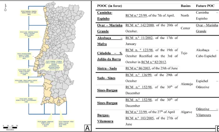
Currently, almost all of the continental POOC are being revised, which will result in the development of five
POCs, using the limits of the 5 river basin districts and
giving rise to the new programmes, as shown in the Figure 5.B. (APA, 2016).
The revision of the POOCs were decided due to their evaluation in 2006 by the Ministry of Environment, Spatial Planning and Regional Development that determine the need to review the provisions of these land management instruments, the upgrade of plan proposals, unequal treatment of land and sea tracks protection, lapses, inaccuracies and cartographic disabilities, inflexibility of beach plans and non-execution of the operating units of planning and management (APA, 2016). The results and insights obtained in the ENACC, 2013 report on adaptation to climate change and the Coastline Work Group (GTL) final report were also incorporated in the creation of the POC. The results of this report point to the need to adopt a new strategy, adaptation, which
integrates other types of responses beyond protection, namely relocation and accommodation. The combination of these three strategies proves to be the most appropriate solution since it allows for greater sustainability of the social, economic and environmental options. The main goals of the POOCs are still imposed in the new POC but are restructured and enhanced, being organised around a set of key components: i) the Spatial component, through mapping the areas to be protected and safeguarded; ii) the strategic component, associated with the principles set for an approach able to establish the mitigation actions; iii) the normative component, based on the provisions of the Legal Regime of Territorial Management Instruments; and, iv) the management component, associated to the programming and monitoring of the implemented actions. This way the POCs should be prepared using the assumption that it is necessary to require safeguards and articulate different territorial management tools as well as a set of other legislation, projects and programmes focusing on the intervention area.
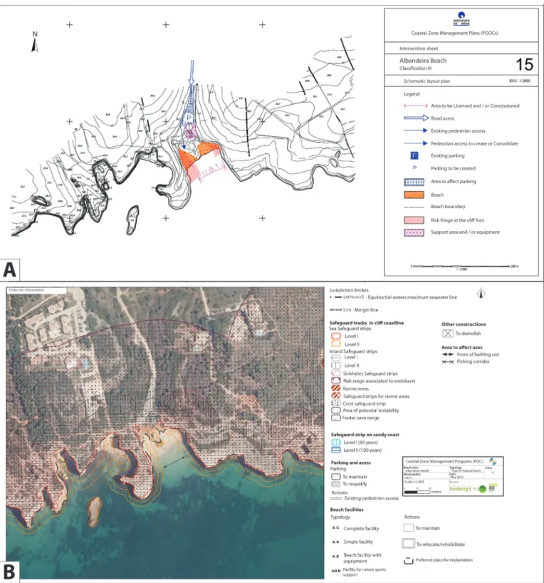
For instance, associated to the spatial component there are noticeable differences between the old (Fig 6.A) and new beach plans (Fig 6.B.), with an improvement in detail due to the inclusion of extra data to guarantee knowledge of all the hazard areas such as safeguard areas through all
the sector instead of only the beach area. Also carrying capacity has been defined for each beach plan taking into consideration the beaches available safe bathing zones per beach typology. These plans are more accurate and have a more integrated approach.
4.1.2 Regional and Municipal
The Regional programmes set out the strategic choices of the regional territory organisation and the appropriate regional structure model, defining the major options of public investment with positive regional impact (Fig 4). The Regional Spatial Plans or Regional Programmes (PROT) established guidelines and occupancy standards, usage and transformation of soil in a sustainable manner in the region under the general guidelines established in the National Programme for Spatial Planning Policy (PNPOT). The territorial model and the guidelines set out in PROT are also a key benchmark for the different sectorial policy interventions affecting the planning of the regional territory. Furthermore, the policy options set out in PROT provide guidance for plans to lower hierarchical order as the Spatial Planning Municipal Plans (PMOT) that incorporated the set of plans of a local scope Municipal Director Plan, PDM (CIEO, 2009; APA, 2016).
Figure 5- A) First Generation of POOCs Source: APA-APA – Planos de Ordenamento de Orla Costeira, at http://www.apambiente.pt/index. php?ref=16&subref=7&sub2ref=10&sub3ref=94, on 24-05-2018. B) Sectors of Portugal’s POOCs, the Council of Ministers approval and the
The Coastal Protection and Appreciation Action Plan for 2012-2015 (PAPVL), published in June 2012, results from the process of analysis and review of the Plan of Action for the Littoral 2007-2013 (Portuguese Government and APA, 2012 and APA, 2016). The
PAPVL presents the priority types of intervention such
as: i) Coastal Defence and Risk Zones; ii) Studies, Management and Monitoring; and, iii) Intervention Plans and Requalification Projects. The PAPVL 2012-2015 report provides a total of 303 actions, with most of the actions of high priority in the Coastal Defence and Risk Zone type (Portuguese Government and APA, 2012). The Office of the Secretary of State for the Environment of the Ministry of the Environment, Territorial Planning and Energy created the Coastline Work Group (GTL)
through Order no. 6574/2014 of 20 May (GTL, 2014). Furthermore, within each municipality there are Spatial Planning Municipal Plans (PMOT) that incorporate the set of plans of a local scope Municipal Director Plan (PDM), the Urbanisation Plans (PU) and the Detailed Plans (PP).
The PDM are mandatory and indicate the municipal territorial development strategy, the territorial model, infrastructure location options, collective equipment use and interdependencies with neighbouring municipalities. Although municipality interdependencies are stated in the PDM and can lead to conflicting decisions the intermunicipal programmes are of optional elaboration. Within the PDMs, the PU provides the framework for the application of urban policies such as land use regime and land transformation criteria while the PP defines the detailed occupation of any specific area of the municipal territory. These municipal plans and programmes are very useful for regional sustainability but as the governance is mainly national with municipalities having relatively limited responsibilities, the best decisions are not always achieved when related to specific areas.
4.2 Climate change specific legislation and tools
The EU Commissioner for Environment, Maritime Affairs and Fisheries assessed that the Portuguese mainland is mainly at risk of Sea Level Rise (SLR) and changes in both, the direction and the power of waves and storm surges. Consequently, they establish that Portugal’s coastal zones are very vulnerable to flooding, erosion, freshwater shortage, and potential loss of ecosystems. The steps for managing climate change began with the National Programme for Climate Change (PNAC) of 2006 that set up the instrument of Government policy that supports compliance with the Kyoto Protocol by the Portuguese State (Canaveira and Papudo, 2013). Now the PNAC 2020-2030 has as goals to: i) promote
the transition to a low-carbon economy, generating more wealth and employment; ii) to ensure a sustainable GHG emissions reduction path to reach a target of -18% to -23% by 2020 and -30% to -40% by 2030, compared to 2005, ensuring compliance with national commitments and putting Portugal in line with the European objectives and the Paris Agreement; and, iii) to promote integration of mitigation objectives into mainstreaming policies. In 2010 the National Climate Change Adaptation Strategy (ENACC) was approved with the first report being available in September 2013 (Resolution of Council of Ministers No. 24/2010). Although many
adaptation initiatives were already underway at both sectoral and local levels, the strategy allowed the public administration and sectors to reflect together and articulate both the awareness of climate change and its impacts, based on up-to-date scientific knowledge, as well as on the identification of the measures that Portugal will have to take to minimise the effects of climate change (Canaveira and Papudo, 2013). Furthermore, there is a strong commitment to link the stakeholders and the literacy of the population in general. Reports were produced outlining the predicted climate change and what should be done.
For the coastal areas where the previous POCs have actions, it was announced that due to the extension, environmental value, morphological diversity and vulnerability of the continental coastal strip, combined with the fact that it concentrates about 75% of the Portuguese population and 85% of GDP, the adoption of a Sector Strategy on Adaptation to Climate Change Impacts (ESAAC-RH) was fully justified. The latter results from the sectoral particularisation of the lines of action and the general adaptation measures defined in the framework of the ENAAC and most of these actions are starting to be incorporated in the management policies (Canaveira and Papudo, 2013).
In the light of the monitoring carried out by the entity responsible for the management of the water resources of the Municipal Plans of Territorial Planning involved in the coastal and estuarine borders, the approaches carried out, to a greater or lesser extent, have gradually considered climate change and adaptation in their regulations. The second generation of POOCs will explicitly introduce the incorporation of climate forcing scenarios and their adaptation measures for defined time horizons (50 and 100 years), which is an example of the ongoing review of the POOCs. The risk / safeguard bands contained in some POOCs, although not initially designed to absorb the impacts of climate change (e.g., intensification of the erosion process), have been projected as preventive risk mitigation functions, thus constituting an adaptation
Figure 6. Example of beach plans. A) Beach plan in the POOC (adapted from POOC available at https://www.apambiente.pt/index. php?ref=x146); B) Beach plan in the POC (adapted from APA, 2016).
measure. The calculation and dimensioning of risk and protection bands in the sandy coast, which incorporates the expected impacts in a scenario of climate change (e.g., mean sea level rise), which translates into a figure of planning, adaptation and preventive risk management over a minimum time horizon of 50 years is now to be included in the management plans (Canaveira and Papudo, 2013). At a local level, the Network of
Municipalities for Local Adaptation to Climate Change (ClimAdaptPT.Local) was formed in 2017 and includes 30 Municipalities of Portugal, as well as other public and private entities directly linked to climate change. The first annual seminar was on the 24th November 2017
and featured the active presence of several national and international experts on climate change adaptation, who, together with local authorities and decision makers from
all over the country and other participants, addressed a wide range of key issues in this area.
The ClimAdaPT.Local project aims to initiate a continuous process of elaboration of Municipal Strategies for Adaptation to Climate Change (EMAAC) and its integration in the tools of municipal planning such as POOCs and PDM. The aim is to achieve this objective by training the municipal technical staff, raising awareness of local stakeholders and developing tools and products to facilitate the elaboration and implementation of EMAAC in participating municipalities and, in the future, in other Portuguese municipalities (available at http://climadapt-local.pt/). For instance, in the Algarve region, the municipalities came together through the association of municipalities of the Algarve (AMAL) with the collaboration of universities and research centres. To create models used to simulate the evolution of the coastline at various time scales, with reference to the IPCC 2013 scenarios by characterising the various activities and variables (precipitation, heat waves, MSL rise, coastal erosion, lack of sediment supply) to create and adapt protection and defence strategies.
4.3 Socio-economic impact studies and tools
The Coastal Zone Management Programmes (POC) report of June 2016 produced by the Portuguese Agency for the Environment also includes several SWOT analyses with strengths, weaknesses, opportunities and threats per thematic sectors (e.g. Resources and natural values; Coastal Dynamics; Marine beaches; etc). The SWOT analyses was the only one that was mentioned in the report, but several others could have been done with more detail and precision.
A Political, Economic, Social, Technological, Environmental and Legal Factors (PESTEL) analysis can also be applied as a situation analysis, it is used to identify the key external forces that might affect an organisation and has been used in several types of studies such as Tourism (Mayaka and Prasad, 2011; Gregorić, 2014) and integrating ICZM (Ballinger and Rhisiart, 2011). Although not generally applied to coastal management, this model can represent an important tool for organising and evaluating possible effects of a coastal intervention. It also provides a simple framework to organise and identify the major forces affecting the studied area (Yuksel, 2012). Normally the PESTEL analysis is the base for the SWOT analysis but in the POCs there is no mention of it, so it is questionable if it was used or not.
Another framework used by the European Environment Agency (EEA) is the Driver-Pressure-State-Impact-Response (DPSIR) framework according to which there is a chain of causal link starting with ‘driving
forces’, through ‘pressures’, to ‘states’ and ‘impacts’ on ecosystems (environment and anthropic systems), eventually leading to political ‘responses’ (Kristensen, 2004). Both models may be defined and adjusted to address concerns that may be of special interest for different scaled study sites.
5. IMPLEMENTATION ANALYSES
OF EUROPEAN AND PORTUGUESE
DIRECTIVES
According to all the above statements, the European Union guidelines and frameworks are being implemented in the Portuguese Governmental planning and are very well based, but the implementation and clarity of land management instruments (IGT) is questionable.
The European Commission’s Integrated Coastal Zone Management evaluation identified the following Portuguese strengths and weaknesses (European Commission, 2007b): i) strengths – the developing national strategy mainly supported European guidelines; legal support is already in place with some consistency and long-term perspective; adaptive management is gradually being integrated; the importance of working with natural processes and using a wide range of planning and IGTs have been recognized; ii) weaknesses – the lack of climate change and sea-level rise consideration in monitoring processes; measures too general for the protection of vulnerable coastal areas; unclear stakeholder engagement; inadequate educational information; insufficient international cooperation; and a need to improve regional policies. The first problem seems to start with the current institutional framework of the coast. With a high number of entities having a say in the matter, it encourages a fragmentation of competencies and has been criticised for allowing a “divide-and-rule” policy. Furthermore, it creates a bureaucratic panorama progressively unreadable for citizens and ungovernable for policy makers (Schmidt et al., 2014). However, according to the Secretary of State for Spatial Planning, concentrating everything on a single entity would not be the solution. The Portuguese ICZM strategy is implemented via a governance model which operates on three levels (Alves et al., 2013): i) political platform; ii) operational platform; and, iii) knowledge platform that, for instance, due to the high institutional centralisation (government) and the omission of both social/public and market elements in the model, are not as recommended by literature on governance (e.g. Olsen et al., 2006, 2011). The governance is mainly national with municipalities having relatively limited responsibilities, leading to management decisions that do not consider the specific problems according to lifestyles and necessities of specific
municipalities. Broader public information sessions and involving different stakeholders throughout all phases of planning, programme, and project developments, with the necessary socioeconomic analysis via a SWOT is not enough.
Furthermore, the marine spatial planning (MSP) report and the expert conference in 2015 that discussed the Portuguese MSP legal framework acknowledged the Portuguese government’s merit and effort to regulate such an important and complex matter as MSP of its Maritime Space. However, the main conclusion reached by the congress was that both the Proposal and its development process have been unnecessarily opaque and may promote, rather than avoid, conflict, suspicion, legal uncertainty, and waste of time. They lack a solid legal framework and the necessary societal consensus. Stating that it is vital to improve the current legal framework, namely in terms of the proposed system’s actual capacity to promote the public interest, and to improve its clarity and its capacity to ensure the sustainability of future planning and management actions. Therefore, a conference report detailing all summarised aspects was sent to the Portuguese authorities on 30 January 2015, but the Proposal was officially published virtually unchanged (Ferreira et al., 2015). Parties in the National Parliament have already demanded its further discussion with the conference organisers interested in collaborating with the law-making authorities to improve the current legal framework. Reflecting the unstable bridge between governmental and scientific analyses.
Portuguese coastal zone spatial planning and management assumes an adaptive approach that allows the use of existing information to adapt the plan to the knowledge evolution and accommodate to the new circumstances, but there is a long process for approval and implementation of the management tools. For example, the POOCs were evaluated and it was decided in 2014 that they had to be revised and updated. Only one has been approved, while the POC Odeceixe-Vilamoura (POC OV) was only available for public discussion in 2016 and it is still not in force. According to the POC OV documents, there are actions (expected cost € 52,518,768) to be implemented from 2016 until 2021. In 2018, the new POCs are not yet in force so these plans have already been affected and delayed and the actions taking place on the Portuguese coast are still related to the outdated POOCs.
Furthermore, in the new POCs, the beach plans were reviewed, and detailed geological characterization and mean sea level rise projections were included but there are inconsistencies in methodologies and assumptions. For instance, the beaches carrying capacity, calculated per beach plan to establish the allowed number of beach
support infrastructures and parking area, does not take into account the seasonality, in several sectors in the summer months the carrying capacity is well exceeded. Therefore, how to enforce this limitation is an important question. There are several beaches that are so popular that people lie down under hazardous cliffs and on boat runners; there should be an applied study in these sectors to establish the accurate seasonal carrying capacity and management procedures based on it. Moreover, the calculation of the carrying capacity in the POCs is based on the typology of the beach and are simply the beaches available safe bathing zones/X m2 with X varying
according to the typology established in the Portuguese Decree n. º 159/2012. This is a very simplistic and inaccurate methodology considering the complexity of the coastal systems. According to Cifuentes et al. (1992) the calculation of the carrying capacity should consider several parameters, such as the area available per visitor, the weather conditions, the erosion rate of biophysical substrate, the possible influence of humans on flora and fauna and the frequency of maintenance works that might disturb visitors. The process consists of three levels: the physical load capacity (CCF), the actual load capacity (CCR) and the effective load capacity (CCE). In the Portuguese case, the three levels have not been considered, neither in the carrying capacity calculation nor in the definition of the beach typology and if it was, it is not mentioned in any document. Furthermore, all the coastal sectors should be analysed including the rocky cliffs next to the beach area; these are highly sought by tourists due to the elaborated landscape and the views. Generally, Portugal is still in a research and monitoring phase of climate change but at policy level, climate change considerations are being taken into account and some of the strategies adopted aim at minimising the impacts in the long run. To date, the main policy actions are the National Climate Change Programme (PNAC) and the National Climate Change Adaptation Strategy (ENACC). The Network of Municipalities for Local Adaptation to Climate Change (ClimAdaptPT.Local) although still at a beginning stage seems to be a good and solid bet for new and accurate policy making not only at the Municipal Director Plan level but also at national level. The incorporation of Sea Level Rise (SLR) in the coastal management programmes will improve the effectiveness of the plans and sustainability of the coastal sectors.
Furthermore, the management of coastal building in hazardous areas, as those affected by SLR, is very difficult, due to the lack of these guidelines in the past, depending on when the building was built and what legislation was in force at the time. For instance, now an infrastructure would not be built close to the cliff, but