1
Guidelines for the integration of biological and cultural values in a
1
Landscape Interpretation Centre: application in southern Portugal
2
Teresa Batista
1; José Manuel de Mascarenhas
2and Paula Mendes
33
1 CIMAC – Comunidade Intermunicipal do Alentejo Central, Rua 24 de Julho 1 7000-673 Évora
4
Portugal; Departamento de Paisagem, Ambiente e Ordenamento, Escola de Ciências e Tecnologia,
5
Universidade de Évora, ICAAM - Instituto de Ciências Agrárias e Ambientais Mediterrânicas, Núcleo da
6
Mitra, Ap. 94, 7002-554 Évora, Portugal. [email protected]; +351.266749420; +351.266749225
7
2 CIDEHUS and UNESCO Chair - Universidade de Évora, Palácio do Vimioso, Apartado 94, 7002-554
8
Évora, [email protected]
9
3 Departamento de Paisagem, Ambiente e Ordenamento, Escola de Ciências e Tecnologia, Universidade
10
de Évora, Rua Romão Ramalho, 59 7000-671 Évora, [email protected]
11
12
Abstract
13
The city of Évora (the Roman Ebora Liberalitas Julia) is the most important town in Alentejo province
14
(Southern Portugal) and is surrounded by a quite rich cultural and biological landscape involving
15
archaeological sites of several epochs, old field networks and farms, as well as specific multifunctional
16
cultural landscapes, the agro-forestry-pastoral systems called montados. Based on previous studies and
17
land surveys, in which where identified the best preserved sectors and marks around Évora concerning the
18
old cadastral systems, ecological corridors networks and the most important montados areas for
19
preservation, it is presented the main guidelines for the development of an interpretation centre for the
20
cultural and biological values in the Évora region.
21
The methodology applies GIS spatial analysis and multilevel approaches and gives the guidelines for the
22
integration of the different cultural and biological values in a holistic approach of landscape.
23
The conceptual model is presented as well as the results obtained for the Évora Region.
24
Keywords: Old Cadastral Networks, Montados, Biocultural Landscapes, Southern Portugal,
25
Interpretation Centre.
26
2
28
INTRODUCTION
29
There is a need for the awareness rising the biocultural landscapes, since they can not only contribute to
30
the preservation of the sense of place but also to the economic development of rural communities,
31
reversing the tendency of rural abandonment and desertification affecting many inland Portuguese
32
regions.
33
Several approaches can be applied to the touristic development of landscapes, such as areas and sites
34
classification, creation of protected areas, ecomuseums, parks, and others cultural and natural
35
museographical figures. Among these last ones the establishment of Visitors and Interpretation Centres is
36
the most common solution in European countries, since they generally involve few human and financial
37
resources, and contribute to sustainable tourism.
38
Through these Centres, knowledge on ecosystem and geographical features can be improve, giving the
39
visitor the necessary information about the landscape history and tangible and intangible heritage values.
40
Moreover they can promote awareness campaigns and education training.
41
The main objective of this paper is to define the main guidelines for the integration of cultural and
42
biological values in a landscape Interpretation Centre, as well as to characterize the Évora surroundings
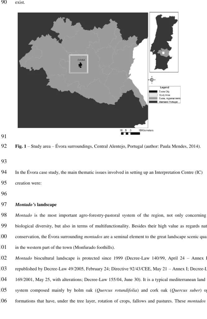
43
landscape and its biological and cultural values in order to identify the most suitable areas to implement
44
an Interpretation Centre.
45
46
METHOD AND MATERIAL
47
Biocultural landscapes
48
Cultural landscapes can be considered as ‘illustrative of the evolution of human society and settlement
49
over time, under the influence of the physical constraints and/or opportunities presented by their natural
50
environment and of successive social, economic and cultural forces, both external and internal’ (WHC
51
2005). This is a dynamic concept since cultural landscape it’s a long-term product of the scientifically
52
demonstrated nature/human interactive process (Fowler 2006). Cultural landscapes are undoubtedly
53
supported by natural environment, soils, water, vegetation and fauna, biodiversity. Biocultural landscapes
54
integrates both natural and cultural elements that interact giving a particular character to the landscape
55
that man shaped for centuries adding permanent disturbance into the system. The result of these
56
interactions is a biocultural landscape that is maintained in a particular balance by man. So biocultural
57
3
landscapes are a particular case of heritage landscape where both natural and cultural values are present.58
A biocultural landscape is related with an intertwined holistic system that has been shaped by human
59
management over long periods of time.
60
61
Interpretation Centres and biocultural heritage development
62
What is the heritage interpretation (HI)?
63
Heritage interpretation can be considered as a creative process of strategic communication which
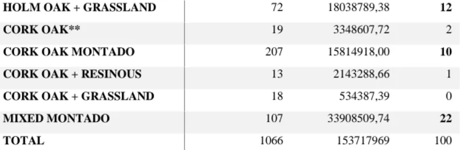
64
produces intellectual and emotional connexions between the visitor and the interpreted resource, allowing
65
the visitor to elaborate his own perception about the referred resource so that he can appreciate and
66
enjoying it (Morales Miranda and Ham 2008). However this concept is not unanimously accepted, it has
67
evolved along time, such has the interpretative practice, especially since the publication of “Interpreting
68
our Heritage” by Freeman Tilden in 1957, considered the interpreter’s “bible” for many people (Tilden
69
1957).
70
These conceptual changes have been analysed by Hector Bazán (2014) who defines heritage
71
interpretation as:
72
- an attractive, relevant, organized and thematic communication process regarding the
73
characteristics of a heritage good (natural, cultural or mixed),
74
- a way permitting the visitor to appreciate and enjoy such good,
75
- through intellectual and emotional links with it,
76
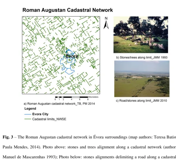
- promoting the creation of personal meanings about heritage and,
77
- a wish to preserve such heritage good so that the future generations can benefit from it.
78
79
The study area
80
The Évora city surroundings, located in Central Alentejo, Portugal, can be considered as a biocultural
81
landscape. It is composed by several important heritage values both natural and cultural as vegetation and
82
fauna diversity and rarity, the existence of important ecological corridors, montados
(agro-forestry-83
pastoral systems), two Roman cadastral networks from different epochs, a Medieval parcels network and
84
many archaeological and architectonic sites.
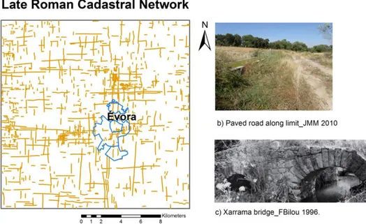
85
The study area includes 36100 ha around Évora (the Roman Ebora Liberalitas Julia), that is the most
86
important town in Alentejo province (Southern Portugal) (Fig.1) and it’s involved by a biocultural
87
4
landscape where, as referred before, many archaeological and architectonic sites (walls, roads, bridges,88
houses) of several epochs, old parcel networks and specific agro forestry pastoral systems, the montados,
89
exist.
90
91
Fig. 1 – Study area – Évora surroundings, Central Alentejo, Portugal (author: Paula Mendes, 2014).
92
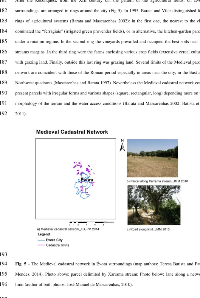
93
In the Évora case study, the main thematic issues involved in setting up an Interpretation Centre (IC)
94
creation were:95
96
Montado’s landscape97
Montado is the most important agro-forestry-pastoral system of the region, not only concerning its
98
biological diversity, but also in terms of multifunctionality. Besides their high value as regards nature
99
conservation, the Évora surrounding montados are a seminal element to the great landscape scenic quality
100
in the western part of the town (Monfurado foothills).
101
Montado biocultural landscape is protected since 1999 (Decree-Law 140/99, April 24 – Annex B-1
102
republished by Decree-Law 49/2005, February 24; Directive 92/43/CEE, May 21 – Annex I; Decree-Law
103
169/2001, May 25, with alterations; Decree-Law 155/04, June 30). It is a typical mediterranean land use
104
system composed mainly by holm oak (Quercus rotundifolia) and cork oak (Quercus suber) open
105
formations that have, under the tree layer, rotation of crops, fallows and pastures. These montados are
106
5
quite diverse in biodiversity, tree coverage and structure (Batista et al. 2014)
. One of the main107
characteristics of these multifunctional traditional landscapes is the persistence of native scattered
108
vegetation throughout the landscape, constructing a heterogeneous mosaic from a variety of grazed,
109
shrubby and cultivated land uses. The montado is a quite old land use system. As Stevenson already
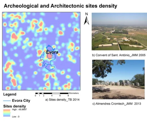
110
stated in 1985 and 1988, a forestry-pastoral system has its origins between 2500 and 1500 B.C. (Batista et
111
al. 2010). Its transformation into an agro-forestry-pastoral system is described in municipal regulations
112
from the 16th century, showing the existence of cereal breeding under arboreous cover. However,
113
according to Fonseca in 2003, it was during the 18th century that this practice was generalised (Batista et
114
al. 2010). Nevertheless as referred by Ferreira in 2001, it was mainly by the end of the 19th century that
115
the great expansion of the cultivated montado happened (Batista et al. 2010). Important structural
116
alterations in the economy of these systems took place during the 20th century: the Iberian black pig,
117
making the best use of acorns, prevailed until the sixties after which it suffered a great regression with the
118
African swine fever; on the other hand, the growth of mechanised cereal culture was responsible for a
119
great regression in the holm oak montado area and, since the seventies, the reconversion of the system
120
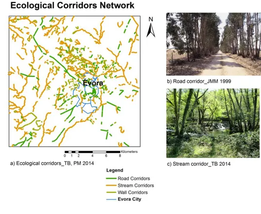
into forestry-pastoral, with the increase of bovines and decrease in sheep production (Batista et al. 2010).
121
This biocultural formation is ‘one of the most aesthetically pleasing and biologically rich landscapes in
122
Europe’ (Pinto-Correia and Mascarenhas 2001). According to the World Heritage Convention
123
classification, the montado landscape is clearly a type of continuing landscape.
124
Cork oak and holm oak montados occupies around 43% of the study area (15.372 hectares), in different
125
tree densities and associations mainly with annual crops, grasslands, broadleaf (mainly eucalyptus),
126
resinous (pines) and mixed montados. Table 1 provides some landscape metrics for holm oak and cork
127
oak typologies: number of patches (NP), class area (CA) and class area proportion (CAP). The main
128
localization is in the northwest and west part of the study area where we can find examples of cork oak
129
and holm oak montados (Fig. 2).
130
131
132
Table 1 – Landscape metrics for montados typologies
133
MONTADOS TYPOLOGIES NUMBER OF PATCHES (NP)
CLASS AREA (CA) (M2)
CAP (%)
HOLM OAK* + BROADLEAF 2 28240,00 0
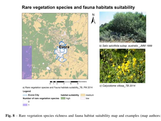
HOLM OAK + RESINOUS 12 1327560,00 1
6
HOLM OAK + GRASSLAND 72 18038789,38 12
CORK OAK** 19 3348607,72 2
CORK OAK MONTADO 207 15814918,00 10
CORK OAK + RESINOUS 13 2143288,66 1
CORK OAK + GRASSLAND 18 534387,39 0
MIXED MONTADO 107 33908509,74 22
TOTAL 1066 153717969 100
*Holm Oak – Quercus rotundifolia; ** Cork Oak – Quercus suber
134
135
136
Fig. 2 –Montado’s landscapes typologies map (author: Teresa Batista, 2014). . Examples of cork oak
137
(above) and holm oak (below) montados (author: Teresa Batista, 2014).
138
139
Old Cadastral Networks
140
In the Évora surroundings there are remains of three old cadastral systems:
141
• Roman Augustan cadastral network
142
• Late Roman Empire cadastral network
143
• Medieval cadastral network
144
The existing marks of those boundaries, have an unquestionable heritage value since they are the "raw
145
material" used by researchers to analyse old cadastral networks. According to the World Heritage
146
7
Convention classification these three cadastral networks can be placed between the relict (or fossil) and147
the continuing landscapes (Batista et al. 2010).
148
149
The Roman Augustan cadastral network
150
Dated from the I century b.C., the Roman Augustan field network system (cadastral system), would result
151
from a land division operation granted to native people when the Roman Évora (Ebora Liberalitas Iulia)
152
became a municipium (Clavel-Lévêque and Plana-Mallart 1995). Traces of a probable cadastral structure
153
were identified with a 30-31 degrees of inclination and NW/SE orientation (the same than the kardo
154
maximus and the decumanus maximus of the urban structure) and a theoretical matrix of 20 x 20 actus
155
(710 x 710 m, approximately) (Clavel-Lévêque and Plana-Mallart 1995; Plana-Mallart 2002; Barata and
156
Mascarenhas 2002) (Batista et al. 2011). Surveys of the terrain have shown that many network limits are
157
still manifest in elements such as cobblestones and stretches of hollow paths, rural tracks, banks, ancient
158
stone walls, boundary stones, canalized water courses, etc. (Batista et al. 2010) (Fig.3).
159
160
Fig. 3 – The Roman Augustan cadastral network in Évora surroundings (map authors: Teresa Batista and
161
Paula Mendes, 2014). Photo above: stones and trees alignment along a cadastral network (author: José
162
Manuel de Mascarenhas 1993); Photo below: stones alignments delimiting a road along a cadastral limit
163
(author: José Manuel de Mascarenhas 2010).
164
8
165
The Late Roman Empire Cadastral Network
166
Dated of the III century, the Late Roman Empire cadastral system followed land renormatio operations in
167
Ebora surroundings that have begun during the Dioclecian government and his colleagues with tax
168
purposes (jugatio), as recognized in Lusitania at Pax Julia and Conimbriga (Mantas 1990; Mantas 1999,
169
Batista et al. 2010). This cadastral network, with the centuria quadrata module has well (710 x 710 m),
170
shows an orientation close to N/S and is related with important existing roads (kardo and decumanus
171
ways), cross roads and other structures (Fig.4). Certain alignments are coincident with administrative
172
limits (Batista et al. 2010).
173
174
Fig. 4 – The Late Roman Empire Cadastral Network in Évora surroundings (map authors: Teresa Batista
175
and Paula Mendes, 2014). Photo above: paved road along a castration limit of the Late Roman cadastral
176
network (author: José Manuel de Mascarenhas, 2010); Photo below: Xarrama bridge (author: Francisco
177
Bilou, 1996).
178
179
The Medieval cadastral network
180
9
After the Reconquest, from the XIII century on, the pattern of the agricultural fields, on Évora181
surroundings, are arranged in rings around the city (Fig 5). In 1995, Barata and Vilar distinguished four
182
rings of agricultural systems (Barata and Mascarenhas 2002): in the first one, the nearest to the city,
183
dominated the “ferragiais” (irrigated green provender fields), or in alternative, the kitchen-garden parcels
184
under a rotation regime. In the second ring the vineyards prevailed and occupied the best soils near the
185
streams margins. In the third ring were the farms enclosing various crop fields (extensive cereal culture)
186
with grazing land. Finally, outside this last ring was grazing land. Several limits of the Medieval parcels
187
network are coincident with those of the Roman period especially in areas near the city, in the East and
188
Northwest quadrants (Mascarenhas and Barata 1997). Nevertheless the Medieval cadastral network could
189
present parcels with irregular forms and various shapes (square, rectangular, long) depending more on the
190
morphology of the terrain and the water access conditions (Barata and Mascarenhas 2002; Batista et al.
191
2011).
192
193
Fig. 5 – The Medieval cadastral network in Évora surroundings (map authors: Teresa Batista and Paula
194
Mendes, 2014). Photo above: parcel delimited by Xarrama stream; Photo below: lane along a network
195
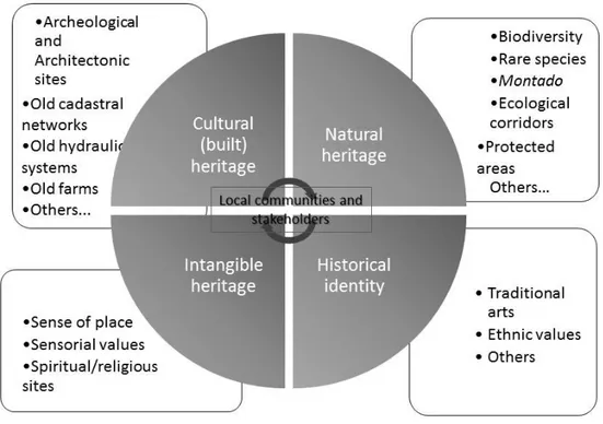
limit (author of both photos: José Manuel de Mascarenhas, 2010).
196
10
Many of these three cadastral networks limits could be identified through the analysis of maps, aerial198
photographs and satellite images and are still materialized by various elements (road marks, slopes, old
199
stone plain walls, property limits, canalized water lines and others).
200
Recent studies carried out by the authors, analysed the relations between Évora old cadastral networks
201
and actual landscape structure (Batista et al. 2012). This study focused the relation between the old
202
cadastral networks and the current land property boundaries, applying the plan persistence perception
203
developed by Marchand in 2000, which allows in particular the understanding of the parcel networks
204
resilience in a long-lasting context (Robert 2003). It focused also the contribution of old cadastral
205
networks to the present ecological corridors mesh, since many ecological corridors are supported by
206
ancient walls and fences. The results revealed that 53% of the Roman Augustan cadastral network
NW-207
SE, 35% of the Late Roman Empire cadastral network N/S and 61% of the Medieval cadastral network
208
are still today land properties limits and 41% of the total ecological mesh is provided by these old
209
cadastral networks (Batista et al. 2012).
210
211
Archaeological and architectonic sites
212
The importance of Évora along the times is mainly related with its location near a remarkable landscape
213
site: the Distribution Centre of the Sado, Tejo and Guadiana basins, and the relatively abundant hydric
214
resources. These conditions help to understand why agricultural and shepherd activities took place in that
215
area since long time, and why it was the main passage way of the center-south road of Lusitânia,
216
particularly in the Roman, Medieval and Modern periods (Barata and Mascarenhas 2002). So, around this
217
old city numerous traces of human intervention such as pre-historic habitats, megalithic monuments, hill
218
forts, roman villae, convents, monastic and secular farms, can be found. During a project developed in
219
Évora University (Mascarenhas 1995), a built heritage (archaeological and architectonic) survey was
220
realized and the heritage value of each monument estimated through a linear combination function where
221
several criteria and weighting coefficients were used (Mascarenhas 1995; Batista et al. 2010). Also the
222
inventory made by the Évora municipality enriched the previous studies with more sites found around the
223
city. The study area integrates more than 400 archeologic and architectonic sites. In the Évora
224
municipality territory, one of the most important pre-historic cromlech in Europe: the Almendres
225
cromlech is located (Fig. 6).
226
11
227
Fig. 6 – Archaeological and architectonic sites density in Évora surroundings and examples (map author:
228
Teresa Batista, 2014). Photo above: Fort and Convent of Saint Antony of Mercy, and Évora Aqueduct
229
(author: José Manuel de Mascarenhas, 2005); Photo below: cromlech of Almendres (author: José Manuel
230
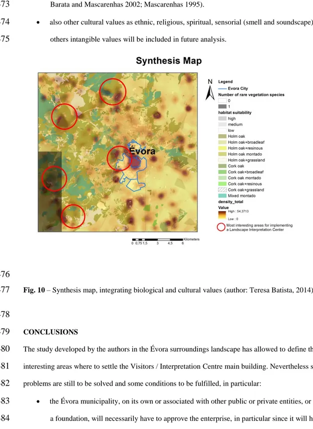
de Mascarenhas, 2013).231
232
Ecological Corridors233
Ecological corridors are considered as one of the most important features in landscape, because of their
234
important role in connecting patches, reducing fragmentation and isolation, transporting water, energy
235
and materials. Forman and Godron (1986) define corridors as ‘narrow strips of land which differ from the
236
matrix on either side’. Hoechstetter (2009), argue that corridors can be regarded as a special case of a
237
patch: a ‘longish’ patch, which is separately considered because of its important functional role in
238
landscapes. Corridors can also be defined according to their functional character as ‘narrow strips of
239
habitat surrounded by habitat of other types’ (Farina 2006). Corridors are especially characterized by the
240
connectivity over large distances and sharp environmental gradients from one side to the other (Forman
241
and Godron 1986). Corridors can be classified as: line corridors (such as roads, hedgerows, propriety
242
boundaries, drainage ditches and irrigations channels); strip corridors; stream corridors (border water
243
Road Corridor
Jmm, 1999
12
courses) (Forman and Godron 1986). Especially important are the vegetation corridors associated with244
habitats and connectivity. The most important ecological corridors in the study area are riparian, line
245
hedges along walls, fences and roads corridors (Fig. 7). These can be composed by trees (arboreal),
246
shrubs and grass in several different compositions. As we seen before, 41 % of these corridors are
247
coincident with the old cadastral networks (Batista et al. 2012).
248
249
Fig. 7 – Stream and road vegetation galleries: localization map and examples (map authors: Teresa
250
Batista and Paula Mendes, 2014). Photo above: trees alignment along a cadastral limit (author: José
251
Manuel de Mascarenhas, 1993); Photo below: riparian gallery along a stream (author: Teresa Batista,
252
2014).
253
254
The vegetation corridors contribute to the ecological networks effectiveness. Bennett and Wit defined in
255
2001 such type of network as ‘a coherent system of natural and/or semi-natural landscape elements that is
256
configured and managed with the objective of maintaining or restoring ecological functions as a mean to
257
conserve biodiversity while also providing appropriate opportunities for the sustainable use of natural
258
resources’ (Jongman 2008).
259
13
Vegetation rare species and fauna habitat suitability261
Évora districts presents several ecosystems included in the Natura 2000 network, with emphasis on
262
montados (Habitat 6310), with a sparse cover of oaks evergreen (Quercus suber and Quercus
263
rotundifolia), grassland and fallows, forming a diverse net of habitats with high conservational value
264
namely Poetea bulbosae grasslands (Habitat 6220 *) and other valuated vegetation as mediterranean
265
temporary ponds grasslands (Habitat 3170*) and chasmophytic vegetation (Habitat 8220) existing on
266
siliceous rocky slopes. On marginal, abandoned or declivous slope areas the scrublands evolve to serial
267
maquis communities such as strawberry-tree (Arbutus unedo) shrubland (Habitat 5330). ).There are also
268
some important riparian forests that contact with montado like small leaf ash (Fraxinus angustifolia)
269
thermophile woodlands (Habitat 91B0), willow woodlands of Salix salviifolia subsp. australis (Habitat
270
92A0), European alder (Alnus glutinosa) (Habitat 91E0), and intermittent streams communities like
271
tamarisk communities (Habitat 92D0). Finally rare, endemic or menaced taxa can be found associated to
272
these habitats like: Limodorum abortivum ( L.) Swartz, Narcisus Jonquilla L., Halimum verticillatum
273
(Brot) Senen, Narcisus bulbucodium, N. fernandesii, and Ruscus aculeatus (Costa et al. 2012; Ramirez et
274
al. 2013).
275
276
On other side, the montado biocultural landscape is a fauna heritage hotspot, hardly related with
277
agriculture and forestry-pastoral activity in the region. The most emblematic species are Streptopelia
278
turtur and steppe species, like Tetrax tetrax and Otis tarda. Mammals like Genetta genetta and Lutra
279
lutra are also important and related with these type of landscape. It occurs also some less frequent reptiles
280
like Macroprotodon cucullatus, and Hemidactylus turcinus e Emys orbicularis species, which have
281
indeterminate status. The Évora region has a medium to high fauna heritage value and habitat suitability
282
(Fig. 8), which needs to be preserved (Batista et al 2010).
283
284
285
286
287
14
288
Fig. 8 – Rare vegetation species richness and fauna habitat suitability map and examples (map authors:
289
Teresa Batista and Paula Mendes, 2014). Photo above: Salix salviifolius subsp. australis (author: José
290
Manuel de Mascarenhas, 1993); Photo below: Calycotome villosa (author: Teresa Batista, 2014).
291
292
RESULTS
293
The landscape as a biocultural interpretative set
294
The interpretation of a territory should be approached as a process through which such territory is
295
understood as a biocultural product, i.e., a physical space where contributions of the different cultures
296
related to it are present and which, consequently, should be considered a biocultural resource (Izquierdo
297
Tugas et al. 2005). Such resource needs data collection, or interpretative set, which gives sense to its
298
communication and interpretation (information centres, explanation devices, etc.). Through these
299
elements, the visitor can approach and enjoy the territory by choosing the heritage fragments that he is
300
interested in, which were not presented before in a very coherent way.
301
The concept of interpretative set is an integrated model showing the biocultural heritage of a territory,
302
perceived as an organization and presentation system of the heritage resources. According to Sánchez de
303
las Heras in 2002, this set allows to understand the territory as an inhabited and open museum in a
304
15
continuous transformation (Izquierdo Tugas et al. 2005). His concept can indeed be extrapolated to the305
landscape level, a phenosystem of the territory (González Bernáldez 1981). The syntagma to interpret a
306
landscape can be understood as to explain a landscape. The landscape is equivalent to a text that one tries
307
to turn readable, so it requires the explanation of the adopted point of view, the reading grids used and the
308
philosophical presuppositions on which the analysis is based. This means to be exposed to critics as the
309
approach to the matter is subjective (Partoune 2004). However, according to this author, the interpretation
310
can also be considered in a linguistic sense, as commonly observed in the environment
311
visitor/interpretation centres and other similar structures, where a translation into the visitors’ language is
312
recommended. Such method based on a simple availability of information does not permit to exchange
313
the message; it is needed to stimulate the public through animation actions to understand landscape
314
dynamics, hoping that it lead to a behaviour of care and protection among the visitors. However
315
landscape is a privileged domain for the emotional communication, to share emotions, thanks to the
316
intervention of field interpreters, which are in general more efficient than self-interpretation tools as
317
boards, leaflets, slideshows, and others. The best results of an interpretation work are obtained in a
318
collective sensitisation and learning context (Partoune 2004).
319
320
The heritage interpretation (HI) contribution to the touristic sustainability of a territory
321
Presently there is a strong debate about the HI potentialities as a tool not only for sustainable tourism but
322
also for environmental sustainability of a territory (Martin Piñol 2011b; Martin Hernanz and Martin Gil
323
2013). According to these authors, HI contributes to conservation through the change of visitors’ behavior
324
and the consequent impact reduction, through a better preservation of the resources and a better visitors’
325
flow management, restricting the access to sensitive areas.
326
As a tool for the sociocultural sustainability of tourism, the HI allows to increase the visitors’ satisfaction,
327
by offering interesting experiences and better opportunities to enjoy the heritage and the landscape. It also
328
contributes to create a feeling of pride and belonging in the local population, promotes the authenticity of
329
the cultural manifestations and passes the territory values onto the visitors (Martin Piñol 2011b; Martin
330
Hernanz and Martin Gil 2013).
331
As Montesellin referred in 2006, on the economic point of view, HI can help sustainability by stimulating
332
the creation of new niches and work opportunities, mainly qualified, by furthering a balance between the
333
economic benefit and the desirable visiting levels and by boosting the local communities to take
334
16
advantage of the resources to create business-related activities of high added value (Martin Hernanz and335
Martin Gil 2013).
336
In Europe the HI has been used mainly as a heritage development tool but its potentialities as a
337
management tool for public use have been little seized. So it seems necessary to change planning and
338
management processes substantially, by adding new criteria permitting to apply more strictly the HI
339
principles.
340
341
What are Visitors and Interpretation Centres of a biocultural landscape?
342
Visitors and Interpretation Centres are equipment’s supporting the management of the tourist activity with
343
different characteristics and functions generally linked within a same welcome structure.
344
In the Visitors Centres (also called reception centres or welcome centres), landscape information is given
345
by a qualified staff, who often presents the synthesis of the local heritage values (natural and cultural) and
346
motivates the wish of better know the referred landscape. In order to facilitate the visit and the correct use
347
of the heritage resources, leaflets, web pages, and other information material, should be provided (Martin
348
Pinõl 2011a). According to this author, it is also important for the visitor to receive a personalized
349
attention in order to clarify doubts, especially about what to observe and how to reach the most interesting
350
sites. As a complement to this support, interactive computer systems often provide additional information
351
regarding the services, times, geographical context, routes, tracks and trails, recommendations, access
352
limitations to some places and heritage elements particularly sensitive in which the visit is conditioned.
353
In general, this kind of centres has also a merchandising space where the visitor can buy publications as
354
well as other articles and very often typical regional products.
355
Finally, unlike the interpretation centres, these visitors centres give no keys for a right heritage
356
interpretation, as stated by Carolina Martin Piñol (2011a).
357
On the other hand, the interpretation centre should be conceived as a reference point which allows to read
358
the interpretative set and works as a central nucleus permitting the distribution of the visitors among the
359
different heritage elements spread over the landscape. A strategy to present the landscape is developed in
360
this centre; it consists in placing the more relevant heritage under a common conceptual marker (concept
361
of interpretation key) and under a presentation unit (interpretative set or landscape-museum) (Izquierdo
362
Tugas et al. 2005).
363
17
To transform natural and cultural (intangible inclusive) heritage resources into highly potential tourist364
products, they must be presented to the visitors in an understandable way. Therefore, according to
365
Morales Miranda, the main function of an interpretation centre is to offer the required keys and reading
366
tools for these heritage resources and the respective context (Martin Piñol 2011a).
367
This kind of centre aims not only at bringing knowledge to the visitors but also at leading them to take
368
interest in the structures and passing its values onto them (Chaumier and Jacobi 2008; Bessard and
369
Robine 2008). This is done through a specific museum planning and promotion actions, including field
370
circuits with explicative thematic panels adapted to several means of locomotion and integrated in the
371
landscape and orientated visits by guides. During these visits there is an attempt at giving the sensorial
372
and emotive aspects the same importance as to the cognitive ones. In the peculiar case of a biocultural
373
landscape, it is also a matter of understanding its history, its cultural and natural heritage values.
374
Then, the Visitors / Interpretation Centre (IC) concerning the Évora biocultural landscape should be
375
physically composed of two main different parts:
376
the main reception centre settled in a building selected among the main important areas;
377
field circuits that integrate the main natural and cultural values.
378
Finally, the IC should be considered a place where the argument lines of an interpretative speech about a
379
biocultural landscape meet. It is the space where a whole vision is given, as well as cultural, education
380
and tourist proposals (Izquierdo Tugas et al. 2005).
381
382
Integration of cultural and biological values
383
The perfect way to integrate biological and cultural values in the same area is to apply the holistic
384
perspective of landscape. As we refer before, rural areas are man managed landscapes that integrates both
385
natural and cultural values in the same region.
386
The central issues of a heritage landscape are historical identity, connecting man and society with nature,
387
natural values, identified and managed by society, cultural values, built up and managed by society and
388
that are recognizable, intangible values, lived and recognized by community and the connection with
389
local community. The Fig.9 shows a schema where different heritage values existing in the same area are
390
integrated. These values are the following:
391
Cultural heritage – built heritage from different epochs, composed by archeologically and architectonic
392
sites, old cadastral networks, old farms, old hydraulic systems, historical features and others;
393
18
Natural heritage – composed by fauna and vegetation heritage (biodiversity and rarity), protected394
species and communities, vulnerable ecosystems (stream corridors), geological, geomorphological and
395
paleontological formations, as well as other important biotic and abiotic structures in landscape;
396
Historical identity – cultural values of local communities, battlefields and other historic events sites,
397
traditional arts, ethnic values and others;
398
Intangible heritage – like the sense of place, the sensorial values like colours, smells, breeze, noises,
399
spiritual and others. In most of the cases this type of heritage integrates the cultural heritage.
400
Many authors integrate historical identity and intangible heritage values in the cultural heritage domain.
401
402
403
Fig. 9 – Guidelines schema for the integration of biological and cultural values in to an Interpretation
404
Centre (author: Teresa Batista, 2014).
405
406
Creation of a biocultural landscape interpretation centre in Évora surroundings: some guidelines
407
The creation of an interpretation centre concerning the Évora biocultural landscape should be developed
408
through a sequential process with the following main phases (Morales Miranda 2002):
409
19
1st phase:
411
Contribution of the interpretation process to a better management of the biocultural heritage.
412
Account of the project strengths and weaknesses; cost-benefit analysis.
413
Interpretative planning, a rational process consisting in:
414
formulating aims,
415
analysing human and financial resources and their potentialities,
416
analysing the targeted publics and the touristic context,
417
defining the messages to be passed on,
418
defining the interpretation means and the required equipment and services,
419
giving recommendations to execute the programs and suggestions to evaluate the efficiency of
420
the intervention.
421
The result of this process is an interpretation plan.
422
423
2nd phase:
424
Specific delineation of means, equipments and programs according to the guidelines of the interpretation
425
plan.426
427
3th phase:428
Execution of the works and implementation of the programs according to the interpretation plan and
429
specific delineations.
430
Detailed museography and scenography program (Drouguet 2005):
431
Programming a museology for which the subject, limits and transversal themes will be defined;
432
Structuring circuit contents;
433
Documentary and iconographic selection;
434
Creating interactive sceneries.
435
Concerning the promotional material (Drouguet 2005): internet site; reproduction of maps, inscriptions,
436
pictures and old films of the landscape, and assessment of their multiple values; elaboration of flyers and
437
field guides, for internet use inclusive; geographic applications to GPS and mobile phones. Along the
438
trails: explanatory thematic boards and signs.
439
20
4th phase:
441
Presentation of the biocultural heritage to the visitor: an action that gives sense to all the previous effort.
442
443
5 th phase:
444
445
Evaluation based on the plan recommendations or on other strategies considered appropriate by the
446
experts of the interpretation service.
447
448
6th phase:
449
Feedback by incorporating the evaluation results in the programs, since the whole system should be fed
450
by its own analysis, in order to better captivate the public.
451
452
DISCUSSION
453
The strategy to select the best sites to the IC implementation (most interesting areas) and to install field
454
circuits, is based on a synthetic map integrating the old cadastral networks limits density, the
455
archaeological and architectonic sites density, the ecological corridors network, the presence of
456
vegetation rare species, the fauna habitat suitability and the montados land cover. Through GIS combine
457
function, all the layers were integrated in order to obtain the best locations for the development of all
458
cultural and natural values.
459
460
The Fig. 10 presents the synthesis map, with the identification of the most interesting areas from the point
461
of view of the integration of multiple natural and cultural values. However:
462
The areas where there is a greater concentration of archeological structures will not have always
463
the vocation for installing visitor trails. Actually, if some of the structures are very sensitive, it is
464
not advisable to direct many visitors to these spots; the same question arises when rare
465
vegetation species and formations or some fauna habitats are concerned; in both cases, the visits
466
should be organized and guided by experts;
467
it may happen that areas with few heritage elements have some cultural or natural (biotic or
468
abiotic) structures which are highly attractive and very suitable for visits;
469
this last aspect is relevant and shows the need to develop this study in a near future in order to
470
estimate the heritage value of the elements existing in the different spots. This can be done
471
21
through methodologies already applied by the authors (see in particular Batista et al. 2014;472
Barata and Mascarenhas 2002; Mascarenhas 1995).
473
also other cultural values as ethnic, religious, spiritual, sensorial (smell and soundscape) and
474
others intangible values will be included in future analysis.
475
476
Fig. 10 – Synthesis map, integrating biological and cultural values (author: Teresa Batista, 2014).
477
478
CONCLUSIONS
479
The study developed by the authors in the Évora surroundings landscape has allowed to define the most
480
interesting areas where to settle the Visitors / Interpretation Centre main building. Nevertheless several
481
problems are still to be solved and some conditions to be fulfilled, in particular:
482
the Évora municipality, on its own or associated with other public or private entities, or as part of
483
a foundation, will necessarily have to approve the enterprise, in particular since it will have to
484
acquire plots and possibly buildings which will receive the Visitors / Interpretation Centre, and
485
will have to find financing for the project;
486
the main nucleus of the centre should be settled preferably in an old farm building with heritage
487
value;
488
22
the success of the interpretation centre as an enterprise comes not only from the quality of the489
scientific and cultural project but also from the project management which must be carefully
490
prepared and highly detailed. According to Carolina Martin Piñol (2011b), most failures which
491
have taken place in Spain during the last years result from unacceptable management programs,
492
due to the poor or null cultural profitability and to the functioning and maintaining costs of the
493
centres.
494
the success of the enterprise depends a lot on the municipality commitment and on the tourist
495
equipment’s of quality existing in the area, as hotels and restaurants, as referred by Martin Piñol
496
(2011b). Évora city satisfies this aspect as it is classified UNESCO World Heritage Site, is a
497
member of the Most Ancient European Towns Network, and presently attracts an important
498
tourist flow.
499
As final conclusion, only the integration of biological and cultural values gives landscape all its
500
multifunctional dimension and brings the visitor the complete experience of landscape interpretation.
501
502
ACKNOWLEDGMENTS
503
To “Territorial and Environmental Observatory of Alentejo, Extremadura and Centro (OTALEX C)”
504
project co-financed by the Cross border Cooperation Program Spain Portugal (POCTEP) - European
505
Regional Development Found (EFDR), to the Institute of Agrarian and Environmental Mediterranean
506
Sciences (ICAAM), University of Évora and to Intermunicipal Community of Alentejo Central (CIMAC),
507
for financial support.
508
509
REFERENCES
510
Barata FT and Mascarenhas JM (2002) Preservando a Memória do Território/ Preserving the Land’s
511
Memories - O Parque Cultural de Tourega -Valverde/ The Tourega-Valverde Cultural Park. Centro de
512
Estudos de Ecossistemas Mediterrânicos - Universidade de Évora, Évora
513
514
Batista T, Mascarenhas JM de, Mendes P, Mantas V (2010) Heritage Landscapes in Évora surroundings:
515
a GIS approach. In Yildizci AC et al. (eds.) Cultural Landscape. Book of proceedings of the 27 th.
516
ECLAS Conference Istambul2010. ECLAS and ITU, Istambul, pp 791-802
517
23
Batista T, de Mascarenhas JM, Mendes P (2011) The fourth dimension in landscape analysis: changing of519
heritage and ecological values in the Évora cultural landscapes. In: Lechnio J (ed.) Four dimensions of
520
landscape. The Problems of Landscape Ecology XXX: 183-193
521
522
Batista T, Mascarenhas JM, Mendes P (2012) Relations Between Évora Old Cadastral Networks And
523
Actual Landscape Structure. Oral presentation on the XV International Conference of Historical
524
Geographers (Praga 6-10 August 2012). Book of Abstracts, p.120
525
526
Batista T, Mascarenhas JM, Mendes P, Pinto-Gomes C (2014) Methodological proposal for the
527
assessment of vegetation heritage value: application in Central Alentejo (Portugal). In: Silva IM, Marques
528
TP, Andrade G (edrs) Landscape: a place of cultivation. Book of proceedings of ECLAS Conference
529
Porto 2014. School of Sciences –University of Porto, Porto, pp 266-270
530
531
Bazán H (2014) Los cambios en la definición de interpretación del patrimonio. Boletin de Interpretación
532
30:11-14
533
534
Bessard M and Robine N (2008) Les centres d’interprétation dans leur relation à la recherche et à la
535
diffusion. La Lettre de l’OCIM 119: 12-17
536
537
Chaumier S and Jacobi D (2008) Nouveaux regards sur l’interprétation et les centres d’interprétation. La
538
Lettre de l’OCIM 119: 4-11
539
540
Clavel-Lévêque M and Plana-Mallart R (editors) (1995) Cité et Térritoire. Annales Littéraires de
541
l'Université de Besancon, Besancon
542
543
Costa JC, Neto C, Aguiar C, Capelo J, Espirito-Santo MD, Honrado J, Pinto-Gomes C,
Monteiro-544
Henriques T, Sequeira M, Lousã M (2012) Vascular plant communities in Portugal (Continental, the
545
Azores and Madeira). Global Geobotany 2: 1-180
546
24
Drouguet N (2005) Questions méthodologiques autour de la conception des centres d’interprétation. La548
Lettre de l’OCIM 98: 13-20
549
550
Farina A (2006) Principles and Methods in Landscape Ecology. Springer, Dordrecht
551
552
Forman R and Godron M (1986) Landscape Ecology. John Wiley and Sons, New York
553
554
Fowler P (2006). World Heritage Cultural Landscapes: What are they?. World Heritage Review, 44.
555
http://whc.unesco.org/uploads/activities/documents/activity-477-2.doc. Accessed 12 December 2014
556
557
González Bernáldez F (1981) Ecologia y Paisage. H Blume, Madrid.
558
559
Hoechstetter S (2009) Enhanced methods for analysing landscape structure: Landscape metrics for
560
characterising three-dimensional patterns and ecological gradients. Rhombos, Berlin.
561
562
Izquierdo Tugas P, Juan Tresserras J, Matamala Mellin JC (coord.) (2005) Centros de interpretación del
563
patrimonio: Manual Hicira. Diputació Barcelona, Barcelona.
564
565
Jongman R (2008) Ecological networks are an issue for all of us. Journal of Landscape Ecology 1(1):
7-566
13
567
568
Mantas V (1990) Teledetecção e urbanismo romano. Geociências, Revista da Universidade de Aveiro 5
569
(1): 75-88
570
571
Mantas V (1999) O espaço urbano nas cidades do Norte da Lusitânia. In: Colmenero AR (ed) Los
572
Origenes de la Ciudad en el Noroeste Hispánico, vol. I. Diputación Provincial de Lugo, Lugo, pp 355-391
573
574
Martin Piñol C (2011a) Estudio analítico descriptivo de los Centros de Interpretación patrimonial en
575
España. Disertación, Universitat de Barcelona
576
25
Martin Piñol C (2011b) Los Centros de Interpretación, un fenómeno de cambio de milenio. Boletin de578
Interpretación 25: 7-8
579
580
Martin Hernanz I and Martin Gil F (2013) Reflexiones en torno al uso de la Interpretación del Patrimonio
581
para la sostenibilidad turística en áreas rurales. Boletín de Interpretación 28: 6-8
582
583
Mascarenhas JM (1995) ÉVORA: Archéologie et Conservation du paisaje Environnant. In:
Clavel-584
Lévêque M and Plana-Mallart R (edrs) Cité et Térritoire. Annales Littéraires de l’ Université de
585
Besançon, Besançon, pp 227-230
586
587
Mascarenhas JM and Barata FT (1997) O Território de Ebora, e a Organização e Ordenamento da
588
Paisagem Envolvente. In: Sarantopoulos P (coord) Paisagens Arqueológicas a Oeste de Évora. Câmara
589
Municipal de Évora, Évora, pp 61-71
590
591
Morales Miranda J (2002) La interpretación del patrimonio natural y cultural: todo un camino por
592
recorrer. Instituto Andaluz del Patrimonio Histórico.
http://www.iaph.junta-593
andalucia.es/Dossiers/dossier1art7.html. Accessed 05 December 2014
594
595
Morales Miranda J and Ham SH (2008) A qué interpretación nos referimos?. Boletin de Interpretación
596
19: 4-7
597
598
Partoune C (2004) Un modèle pédagogique global pour une approche du paysage fondée sur les nouvelles
599
technologies de l’information et de la communication. Dissertation, Université de Liège
600
601
Pinto-Correia T and Mascarenhas JM (2001) Montado (Dehesa) of Portugal and Spain. In: Green B, Vos
602
W (eds.) Threatened Landscapes. Conserving Cultural Environments. Spon Press, London and New York,
603
pp 100-101
604
605
Plana-Mallart R (2002) Le territoire d’Ebora en Lusitanie. In: Clavel-Lévêque M, Orejas A (dir) Atlas
606
historique des cadastres d’Europe II. EUR 19717, Dossier 7. Commission Européenne - Direction
607
Générale de la Recherche, Bruxelles
608
26
609
Ramírez B, Fernández L, Cabezas J, Jiménez A, Mendes P, Vila-Viçosa C, Batista T, Pinto-Gomes C
610
(2013) Bioclimatologia, Biogeografia e Vegetação Potencial na área OTALEX C. In: Ceballos F, Puerto
611
M, Batista T, Carriço C (coord. ed.) 2013 OTALEX C: Resultados del Proyecto. DGTOTU- Junta de
612
Extremadura, Mérida, pp 73-82
613
614
Robert S (2003) L’analyse morphologique des paysages entre archéologie urbanisme et aménagement du
615
territoire – Exemples d`études de formes urbanes et rurales dans le Val-d’Oise. Dissertation. Université
616
Paris I Panthéon -Sorbonne.
617
618
Tilden, F (1957) Interpreting our Heritage. University of North Carolina Press, Chapel Hill.
619
620
WHC (2005) Operational Guidelines for the Implementation of the World Heritage Convention.
621
UNESCO World Heritage Centre, Paris