WORKING PAPERS, N
o07, ABRIL/2015
BUILDING DIALOGUE THROUGH
MAPS
Peter Spink, Centro de Estudos de Administração Publica e Governo
da Fundação Getulio Vargas de São Paulo
Lupicínio Iñigues-Rueda, Department de Psicologia Social,
Universidad Autonoma de Barcelona
Building dialogue through maps
Peter Spink Centro de Estudos de Administração Publica e Governo – FGV/SP Lupicínio Iñigues-Rueda Department de Psicologia Social, Universidad Autonoma de Barcelona Mary Jane Paris Spink Pograma de Estudos Pós-graduados em Psicologia Social, Pontificia Universidade Católica – São Paulo Abril 2015
1. Introduction
The head thinks where the feet walk1
“The right to the city cannot be conceived of as a simple visiting right or as a return to traditional cities. It can only be formulated as a transformed and renewed right to urban life (p.158 Henri Lefebvre Writings on Cities Oxford: Blackwell, 1996)
In seeing like a State, James Scott (1998) emphasized the role and importance of a number of social simplifications introduced in late medieval statecraft, which “not only permitted a more finely tuned system of taxation and conscription but also greatly enhanced state capacity”. Thus standardization of weights, land surveys, population surveys, registers, dictionaries for language, surnames and many other bits and pieces of modern day life that we assume as natural are in fact the consequence of attempts to deal with issues of public health, poor relief and many other aspects of ordered life.
“These state simplifications, the basic givens of modern statecraft, were, I began to realize, rather like abridged maps. They did not successfully represent the actual activity of the society they depicted, nor were they intended to; they represented only that slice of it that interested the official observer. They were, moreover, not just maps. Rather they were maps that, when allied with state power, would enable much of the reality they depicted to be remade. Thus a state cadastral map created to designate taxable property holders does not merely describe a system of land tenure; it creates such a system through its ability to give its categories the force of law”. (p.3)
1 We owe the sub title of this paper to Father James Crowe who has been working in the greater south
From the point of view of those involved in different fields of action, these “abridged maps” are similar to focal planes. They bring into focus what is of interest both textually and contextually, whilst un-focusing the rest. Focusing and un-focusing are equally active and equally peformative. This performative power of mapping is the underlying theme of the
hidden cities project currently underway at the Center for Public Administration and
Government of the Getulio Vargas Foundation in São Paulo; but the way this came to be recognized was anything but simple and far from logically deductive.
This paper seeks to show how the creative use of maps can be key to unlocking problems of dialogue and coordination amongst different public action agencies, organizations and the communities they serve. It is composed of eight sections, including this introduction. Section 2 discusses the methodological approach, which draws on the experience of interactive field stations and the action research tradition and in section 3, the general territorial conditions are presented. Section 4 discusses the dynamics of maps and mapping and in section 5 the themes of positioning and public action languages are introduced. The 6th section discusses some early results and shows some of the maps, whilst the 7th section brings in the focal plane perspective, which has served as an important device for discussing the results in local settings. Finally in the 8th part we discuss the challenges for multi-level democracies of hybrid arenas.
2. Methodological approach
The starting point was an interactive research program that drew on both the action research tradition and the 1950s approach to university extension through field stations (Sommer, 1990). The early focus of the program - which continues with support of the FGV/SP Research Fund2 – was on urban vulnerability and the prevention of disasters associated with heavy rainfall (floods and land-slides), especially in those settings in which different sets of social and institutional actors in different cultural, jurisdictional, organizational and professional insertions seek to develop agreements about substantive questions that require joint action and resource investment.
2 Over the last 30 yearse the authors have had support from many different national and international
That this was no easy setting was realized from the outset from discussions with civil defense professionals and other community based researchers. These discussions gave considerable support to ongoing theoretical work on public action languages, the multiple social languages that crisscross the political economy of public affairs and which may or may not connect with each other and, when do, may often be in conflict (see Spink 2013; Spink & Toledo Silva 2014). In such settings where connection is a random possibility, it had become very clear that amongst the key issues are: how to conceive and work with the complexity of different action languages and the different territories in which disasters were possible and, what social technologies and mechanisms of governance could help promote comprehension and fairness (in the sense introduced by Rawls) in the relationships between public sector organizations and vulnerable populations?
3. Introduction to the territory
São Paulo and the São Paulo metropolitan region is located in a broad water basin some 800 meters (2,500 feet) above sea level and surrounded by mountain ranges (figure 1). Even though it is only 35 miles (55km) from the port of Santos on the coast, all the water from its basin flows inland to form the Parana River, that in turn will pass Paraguay and Uruguay before reaching the sea in Buenos Aires, Argentina. Unlike most of the big cities of the world that can be found near the outlets of their rivers or at least considerable downstream (Cairo, Rome, Paris, London, New York to cite but a few), São Paulo is not just upstream, but sits on top of its catchment area.
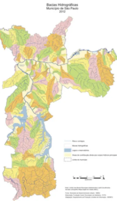
Despite the photographs which suggest that São Paulo is a flat maze of high rise buildings, it is in fact a city full of hills and valleys, from which and through which emerge and flow numerous small streams and rivers; nowadays running through concrete channels under major roads, many of which constructed in former river valleys. Figure 2, shows the many different hydrographic sub basins that are within the municipality of itself.
Figure 2: Hydrographic sub basins in the municipality Of São Paulo
São Paulo is fortunate to have a highly advance technological and scientific infrastructure, including universities and research centers3, amongst which is the State Government’s Institute for Technological Research (IPT). IPT is one of the few centers of applied research that has specialized in risk mapping and it was to the IPT that the research team turned to discuss the question of vulnerability to water based disasters. Amongst the different areas discussed was that of the sub-prefecture of M’Boi Mirim in the south zone of the city where over 50 areas are identified as having serious risks. (It is important to note that the IPT study was carried out for the municipality and looked at areas where there had been invasion of public land. Properties built on land that had been formally or quasi-formally divided into lots was not included. It is likely that in a number of cases these properties, especially those in which there has been subsequent rebuilding and extension, may also be under risk).
The CEAPG had made various contacts in this region over recent years and it was suggested we should talk to one of the faith-based social organizations in the region, linked to the Santos Mártires Catholic Church4 in Jardim Ângela, one of the two districts of the M’Boi Mirim regional sub-prefecture. The Santos Mártires Society was set up in 1988 following the formation of the parish in 1987, to respond to an urgent need for very basic social services at a time when these were non existent in this region.
Linked to the Church and the Society are a number of important social forums that gather together activists and representatives of different public organizations, service providers and universities concerned with social change. The most well known of these is the Forum in Defense of Life (Forum em Defesa da Vida), which has been meeting on the first Friday of every month since it was created in February 1997. At the time there had been a radical increase in violence in the region and Jardim Ângela had been declared the most violent place in the world (UN May 1996). The Forum serves as a horizontal gathering point to talk about social issues in the region and connects many key local actors with other institutional representatives.
The Forum is an open event with diverse participants who at each meeting introduce themselves in equally diverse manners. Who turns up is who makes the Forum at that point in time. For example: territorial belonging I am a resident of Vera Cruz”; political activism
“I am a member of the movement for urban mobility”; or profession and program (“I am a social worker at the Santos Mártires Society”). Some are from church based organizations (“I am a Franciscan missionary”; “I am a rabbi”); others are academics (“I am from the University of São Paulo”) and still others are linked to public services (“I am the director of a school”; a” basic health unit”, “the policeman in charge of the local community policing unit”, “a worker at city hall”). Each of them is a link to further networks of activists and to
day-to-day activities.
The south zone of São Paulo can be divided into three areas: the first is what those in the more wealthier central regions call the south zone (zona sul) which starts at the Paulista Avenue and goes out past the Ibirapueira park and the well urbanized houses and flats toward the regional airport at Congonhas. The second starts more or less at the airport and covers what used to be the municipality of Santo Amaro, founded some 400 years ago and annexed to São Paulo in 1935. It crosses the River Pinheiros and splits in two parts, one on either side
of the Guarapiranga reservoir and occupying a significant part of its catchment area. As it crosses the river (over three different bridges) it materializes expressions that are often heard when discussing the differences in distribution and quality of public services and the way the police act: this side of the bridge; the other side of the bridge. This is where the third area begins.
For the planners in the city hall, this is part of the periphery (periferia) of São Paulo; an expression that is used to talk about the outer zone of the city, towards its limits with adjoining municipalities. But it is also an expression that positions people as being working class – which in Brazil is often synonymous with having low incomes – with substandard housing, not very good education and often being problematic.
Figure 3: The sub prefectures of the São Paulo Municipality
Jardim Ângela and Jardim São Luís form one of these small “municipalities”: the sub prefecture of M’Boi Mirim. Together there are over 600,000 inhabitants, which would make it one of the thirty largest municipalities in Brazil. The whole area of the two south zones that surround the Guarapiranga Reservoir and make up a large part of its catchment basin has just over two million inhabitants (larger than the State of Rondonia). Very few people talk about M’Boi Mirim as a place; they talk about three areas, Jardim Ângela, Jardim São Luis and Capão Redonda (which is part of another prefecture) or about their own neighborhood (usually also described as Vilas or Jardim). But they will talk about M’Boi as the road – the only road – that goes through the center of the region and leads people to the train/bus network in Santo Amaro. When the M’Boi stops, nobody goes anywhere. (M’Boi comes from the indigenous Guaraní people’s word for snake and Mirim means small).
A recent document published by the Municipal Secretary for Social Assistance and Development (SMADS) analyzing the different regions of São Paulo states that in the region of M’Boi Mirim, some 36% of the population can be classified as being in high and very high vulnerability, which rises to 50% in Jardim Ângela. The description continues with an appraisal of social services:
“In relation to the network of social services, the area of the sub prefecture has 79 different service units capable of attending together 16,610 clients and is the most well equipped of the southern zone 1. Of these units the Municipality directly runs three (2 CRAS and 1 CREAS). Amongst the services that are contracted, the major part is focused on children and adolescents……….”
The three service units, of which only two are active, that are run directly by the municipality are the coordinating units for social welfare (known as reference centers in the terminology of the National Social Service system - SUAS). A simple calculation shows that the remainder – seventy-six – are run by other organizations in the region; that were there long before the effective arrival of the local state and the new social welfare system.
Being in a setting characterized by social and material vulnerability is serious enough, especially when the institutional framework has great difficulty in meeting the challenges that need to be faced. However being in a setting that is also to a certain extent invisible to those who can and do play a major role in determining government action takes vulnerability into a very different dimension – and certainly one which has very little to do with the current international development agency based debate on urban resilience. This was the beginning of the hidden cities project and our awareness of the importance of the politics of
4. You can’t map without maps
Life didn’t stop during the long period that the west depended on the Roman numeric system. However it is difficult for us to understand how shopkeepers dealt with questions like XXII chickens at IV each. Our modern numbers are Arabic inventions and include a very interesting idea: “0”. Numbers we could say, live in tables, they talk about percentages and call attention to size and comparisons – which can be very important. What is, for example, the relative size of Jardim Angela and Jardim São Luis in comparison with other Brazilian municipalities? Hardly a stone throw from the border of M’Boi Mirim are the municipalities of Embu Guaçu, Itapecerica da Serra and Embu das Artes. The first has a population of 62,769, the second of 152,614 and the third, 240,230. As they are municipalities, they have the full “kit” of institutions and institutionalities that are guaranteed by the Brazilian constitution. Jardim Ângela has a population of 295,434 and Jardim São Luis of 267,871 and as far as the constitution is concerned, they don’t exist. They are invisible to the institutional eye, hidden away and out of sight. The municipality of São Paulo created sub prefectures but these are organizational in form and their attributes can vary depending of the extent that the municipal executive is more centralized or decentralized. The former is the rule and the latter is only a hope.
These comparisons are important as they show an area that (a) would be a very significant municipality in its own right and (b) that its presence in terms of the municipality has grown from a population of 10,902 inhabitants (0,51% of the municipality) in 1950 to 563,305 (5%) in 2010. But what were Jardim Ângela and Jardim São Luis in 1950? What did the urban area look like at that time? This is where numbers give way to maps, not as descriptors but as actions that format territories.
maps made by the state statistical bureau, almost never identify the period in which Santo Amaro was a municipality in its own right.
For those who actively use street numbers (such as taxi drivers and delivery vans), the presence of Santo Amaro continues to today. The Brazilian tradition is to number streets from the point nearest the center of the town (1 or 2) to the point furthest from the center. As the observer moves outwards from the first south zone towards the second, there is a point at which street names change, numbers invert and begin to decrease. These are the old streets of Santo Amaro, whose archeological signs will lead the researcher – as if through a social version of Atlantis – towards the center of another hidden city, its church and squares. Few who travel from the center down the wide Ibirapueira Avenue know that they are on the old tram line from São Paulo to Santo Amaro and few who get to the wide circle of Socorro near the bridge of the same name know that it was here that the trams turned around to head back to São Paulo. There is no intention here of suggesting a simple causality between the “disappearance” of Santo Amaro and the later difficulties of M’Boi Mirim – but it is at least worth registering that the original M’Boi Mirim is a river some 16 kilometers still further south of the center of Santo Amaro and the road was the road to M’Boi Mirim. How that became the name for the sub prefecture is an open matter, but it certainly was not the name that the residents would have used to refer to themselves.
Paulo) and Aldaiza Sposati’s Cidade em Pedaços5. The Municipal Planning Secretariat, the Housing Secretary and the State agency EMPLASA have also produced very useful documents. Their maps, in general have – by the requirements of academic publications – to be fitted in to a standard printed page. Placing São Paulo onto a printed page leads to a maze of dots that have only a generalized relationship to territory and, at the best, provide broad tendencies. They are maps that social planners might use, but not maps that those who live in a specific place might use to think and discuss about what is around them.
In our work we have needed to discuss with people what happens and where; how they get from A to B; where the schools and health centers are located; where they go to pay the bills and register those things that need to be registered, even where the churches are, the police stations and the many other bits and pieces of daily life. As mentioned, this is an area of hills and valleys; one of the watersheds of the São Paulo basin. Hills, valley, water and self built housing – especially when the latter takes place without much guidance as to sites and services and in time goes from lateral to vertical expansion – usually spell danger, especially in the semi-tropical zone where rains can be very heavy and torrential. There is little point in showing risk areas as black dots on an empty map, when they are in the middle of streets and houses.
It is probably when the researcher is faced with the option of using a geo-referenced, Google type computer based map which may be great for zooming in and out on a computer screen, but not much use for holding a community based conversation in a garage that doubles as a chapel or a school hall, or getting people to point to how they get from A-B or search for the landmarks that are familiar, that the political economy of maps and mapping begins to become clearer. Maps help to show things but in doing so hide other things. In any street newsagent it is possible to purchase a town reference guide to the streets of São Paulo. These guides, that can be carried in a backpack or in a car are excellent for looking at the local level – similar to zooming in on a computer map. But any attempt to zoom partly out and see what connects to what, requires jumping from page to page. So in order to map you have to have a map and the possibilities of the one frame the scope of the other. Map and guide publishers will produce intermediary maps and do so for regional planners and other professionals at a considerable cost; for these will be on-off productions that will be framed and put on the wall so that technical staff can locate where they need to go. But they are far too costly to write on, stick pins or notelets.
After a number of experiments we found a standard street guide with a reasonable scale (approximately 6cm to the kilometer). By cutting and pasting we produced a fairly decent base template – a map on which to map – that fitted the largest size of standard commercial paper at the local copy-shop (approximately 60cm x 90cm). It covers an area of approximately 10 km by 16 kilometers, with very clear and key landmarks (the rivers, the roads, the reservoir, the parks). For US$ 8 a copy we had something that we could draw on, others could draw on, that could be stuck with tape on a wall and that nobody needed to be worried about knocking the computer off the table or about carrying around a projector or putting marks on an expensive map. We could all make mistakes and start again; we could try mapping one-way and then another. People could gather around and stick different colored circles and squares, develop different symbols for what went where.
As we experimented, drawing in the municipal boundaries, the sub-municipal boundaries, coloring in the principle roads, Kevin Lynch’s seminal work seemed to be watching from the bookshelf 6. We had a map on which to draw our maps and from which others could draw their maps; we could look at the different spatial arrangements used by service planners and others and – what is more – were no longer dependent on the continuity of city hall’s web site or the openly available information of this or that agency which may be here today but gone tomorrow (as was indeed the case in one of the areas of public services studied). Our hidden cities were no longer invisible.
Figure 5: an early map
From that point on we had a project and the hidden cities debate began. We had cities that we could talk about with others in way that they could relate to and check whether the little colored circles were really there, or were in the right place. We were not describing, but redescribing and in doing so were performing collectively different ways of being.
5. On positions and public action languages
are used to the slight fuzziness between different ways of looking and the more collective and collaborative ( that is connective) is a particular setting the more likely it is that we share – what to all extents and purposes – can be called a common social view.
It follows that the less collaborative, the less collective and therefore the less connected are the different parts of a particular setting the less likely this will be the case. In the day to day these different relationships can assume very different gradients and positions, as expressions such as “speaking as a resident of…..” testify. These different ways of “positioning” are also reflected not only in places but in the different social languages that circulate in the public sphere.
It is helpful to point to two major differences in positioning: that from the point of view of the major representative (president, governor, prime minister, mayor or similar) and that from the point of view of the citizen in the day to day. For the former, concerned with the implementation of programs and policies, the different services are like the different parts of a fan, each of which spreads out towards different groups or populations. When she or he gathers together the members of the executive (ministers, secretaries, program managers) her or his concern is with the coherence of these different activities as part of a government platform or action agenda. Friend (1977) referred to this as the “government policy space”. For the citizen in the day to day, the situation is the reverse. Her or his social reality is made up of very concrete questions and issues linked to different demands and rights. A single mother with a young baby who needs to work; an elderly person who needs to move around; a youngster looking for books that aren’t in her school library; another young person looking for cultural outlets. Their day to day (their “life space”) in relation to state action is made up of bits of different questions, which are treated by different bits of the different organizations whose actions fan outwards toward everyday life. The executive or cabinet or policy committee wants “implementation”; for the citizen, their family, friends and neighbors the concern is with where things are and how to get to them: “where do I have to go to solve XYZ”. Friedmann, 1992, used a similar approach in referring to those aspects of the day to day that were key in social power and the key role played by state agencies in helping or hindering the search for: financial resources; social networks; appropriate information; surplus time over subsistence requirements7; instruments of work or livelihood; social organization; knowledge and skills; and a defensible life space.
On top of these different starting points which are often simplified as top-down and bottom-up it is necessary to add that as the different parts of the fan enter into action so do different languages begin to appear; both from the top downwards and from the bottom up.
In discussing public affairs it is very common – if not almost inevitable – that the discussion at some time will come round to public policy. Indeed, we assume policy and public policy as natural synonyms for democratic activities (“what governments do and do not do”, Dye 1981). However as we have discussed elsewhere (Spink, 2013, Spink & Toledo Silva 2014), the centrality of policy and public policy is in fact very recent; at least when set against the many different advances of the modern period from the 17th century onwards.
The drift to public policy started to take effect shortly before, during and largely after the events of the Second World War when a number of the more senior democracies were advancing to consolidate a new kind of state-society-citizen-government relationship. Public policy may be the language used today when talking about the actions of governments in many different fields, but it certainly wasn’t the language or languages that set them in motion, many of which are still around enacting every-day affairs. They are just as performative (Austin, 1962) as public policy.
After all what do planners do if they don’t plan and produce plans; charities are, of course charitable and show brotherly and sisterly love; keepers of the budget prepare the budget which until recently would be carried to parliament in a little bag or bougette; rights activists are concerned with violations and issue mobilizers usually have no time for budgets, plans, policies, systems or even rights – they just want action. There may be cooperation and connections between these different ways of actively doing and being public affairs, but there are equally conflicts and disconnections.
not merely to the activities of the state directed to the public, but to quote from Dreze & Sen’s 1989 Hunger and Public Action:
By public action we mean not merely the activities of the state, but also social actions taken by members of the public – ‘both collaborative’ (through civic cooperation) and ‘adversarial’ (through social criticism and political opposition) […] the reach of public action goes well beyond the doings of the state and involves what is done by the public – not merely for the public. (1989 viii)
Their concern was with the whole problematic of hunger where, as they concluded, “the collaboration of the public is an indispensable ingredient of public health campaigns, literacy drives, land reforms, famine operations, and other endeavors that call for cooperative efforts” (p259), including the adversarial pressure for change. If we add to this not just the adversarial pressure but the action of the public directly for the public – also present in the solidarity and search for alternatives – then the public sphere begins to take on a different dimension. This has been a common theme in the work of Thoenig:
“The public service, both in the common law tradition and within the roman law perspective, does not have the monopolistic control of public affairs… from law and order, protection against fires, environmental policies to education, land use and social benefits. Hybrid institutional designs and vague statutes are common practice. […] The State is far from being the Lord and Master and having exclusive control of public affairs, from the definition of what should be the object of action, to the design and implementation of the services themselves”. (Thoenig, 2007 p.13)
Public action languages are not distributed in an equal manner. From one part of the broad public affairs field to the other, there will be preferences for ways of talking and performing action. For example, in the health field in Brazil there is much talk about rights; many national attempts at articulation are expressed in terms of systems and the Purchasing Law 8666, which all government buyers and financial managers know by heart, has more influence on determining what can or cannot be done than, for example, the budget. In urban affairs it is not possible to go very far without meeting planners and their planning instruments yet, in the same urban space citizen groups will mobilize around very specific issues which they want solved, plans or no plans.
In a reasonably effective and complex modern democracy we assume that there will always be disconnections but that these will be object of debate discussion and attempts at improvement8. We assume effort by those in direct contact with the public (Lipsky 1980); availability of information (production, clarity and access); deliberate intentionality by senior administrators; concern by representatives and actions by citizens themselves. However
citizenship is a relational concept that is performed in a person’s/grouping’s/collective’s relationship with officials of some kind.
To the extent that these different bits and pieces reach some reasonable degree of connectivity, we can argue that citizenship is possible. When these different bits and pieces hang in the balance, we might be led to suggest that citizenship is becoming precarious. When they go upside down and are fragmented, perhaps we have to face the prospect that citizenship – as it is commonly understood – is becoming impossible, or, more precisely, is being denied. In our hidden cities, invisibility as process can, it appears mean precisely that.
6. Early results: introducing institutional vulnerability
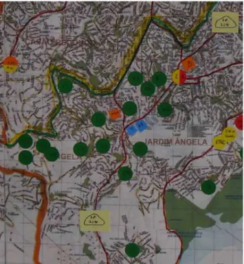
The illustrations that follow show the initial results of the “turning visible” exercise. Our first map, as well as noting the various jurisdictional boundaries with neighboring sub prefectures and adjoining municipalities, looked at the areas that had already been identified as being at risk of land slippage and flooding. The full map appears in figure 5, Figure 6 shows an enlarged part of it – very much as somebody standing by it would see.
Figure 6: areas at risk
The municipal social services department point to two key centers as the entry points to their support services. But their own map and web site does not show the over 70 services that are spread across the territory and receive financial support from the same secretariat to provide key social and welfare services. Many of these, like the crèches, were there before the local state arrived and are considered by the department as contracted out services. Due to recent changes they are not allowed to act as referral points and have to send people looking for support to one of the two coordinating centers that are located at the top of the map. (Which, incidentally, is where the sub prefecture is located, convenient for access to the center of the town and city hall but almost on the upper limits of the territory and 16 kilometers away from its southern boundary with a neighboring municipality).
Health, coordinated under the Unified Health System (SUS) has a broad network of basic health with some 32 health centers spread territorially, but slightly more in the north and center than in the south of M’Boi. The south has been a focus of recent expansion and land invasions. Health centers are open and there is a family health program that works on outreach. Its big problem is secondary health care, exams, surgery and more complex care requirements. There are two public hospitals that try to cover nearly a million people and thee are serious logistical problems with exams, with the mobility of key health personnel, many of which have to move in and out of the region daily.
Public transport until very recently was in virtual collapse with two main roads trying to cope with the demand of buses and a population that basically has to leave the region in the morning to work and return at night. Everything goes in and out along the roads which are also the places where a few banks, correspondent banking points such as the national lottery and a few large retail chains, and most of the commerce is located.
concrete floor and flat roof supported by reinforced pillars will sustain what over time could become several other dwellings, as the previous photographs show).
Figure 7: part of a display of maps in a community chapel Jardim São Luís
Using as a very simple indicator of vulnerability, the areas identified as being at risk9, we find that there are very few services – even health – that are well spread in relationship to them and those that are reasonably co-located are often from the various faith based social organizations linked to the catholic church. We will return to this theme in the final section.
7. The focal plane perspective
Any photographic camera lens will have a focal plane that can be adjusted either automatically or manually depending on what is in focus. On the more sophisticated digital cameras, it is possible to not only preset for flowers, mountains, faces, but also to get the camera to do that automatically. When someone take a picture of flowers, the background fades away, as also with faces; when they take a picture of mountains, the foreground fades
9 In the over 50 areas which are seriously at riske there can be anything from 20 to 300 or more families.
away. Depending on where the focus is, the rest – before or after – will fade away. This very simple image – mechanistic and certainly not very elegant – serves for what we are finding. From area to area of the public arena, the different agencies will “see like a state” but will do so not even in the unified manner proposed by Scott – which is complicated enough – but in their own way. The “state” on primary education; the “state” on social services, the “state” on culture.
It may seem obvious but it is necessary to re-emphasize that when health planners think health they think epidemiology (when the São Paulo State coordinators for dengue fever thinks health they think of mosquitos flying around – they don’t think of jurisdictional boundaries); when the State regional coordinators of education think education, they think primarily of middle and high school education, depending on the area maybe even primary school, but certainly not of infant education. As we move around the different maps it is as if we are moving between different focal planes. On each there is a whole life-world of activities, organizational responsibilities and mechanisms of coordination; not to forget the different languages. On each focal plane the view from the management team outwards and from the citizen inwards will be different in different ways.
In the everyday life of residents and user of a specific part of the map, the horizon is also made up of the myriads of places to buy food, pay bill, send letters, get buses and the hundreds of other aspects of urban life. Residents – those who reside in and are the focus of the different service managers concern – are constantly crisscrossing these different focal planes. They – and not the service managers and specialists – have no option: they have to act across the different sectors, move between the different planes, zigzagging backwards and forwards.
The many different service workers – on the other hand – are constantly required to remain within their focal plane. Some at least are concerned with the articulation and linkage of actions within the plane, but others are required to concentrate on the task at hand. The teams from the basic health service must report on and link potential patients with the next tier of services, or organize for them to do their exams; the center for technical education is concerned with its classes, students and teachers. The story changes from map to map, but the dynamic of perspectives continues. Here is a much earlier observation from George Herbert Mead (1932):
do not wish to belabor the point, which is commonplace enough, but to suggest that we find here an actual organization of perspectives, and that the principle of it is fairly evident. This principle is that the individual enters into the perspective of others, insofar as he is able to take their attitudes, or occupy their points of view. (p.346)
If we think about vulnerability in its social, material and institutional form it is clear that Mead’s limitations of social organization apply – at least in the case of our maps – to the third of these vulnerabilities. For if the different institutional actors – of which there are many – do not connect each with the other in their work, it is as if there were – for all practical effects – an assortment of randomly distributed fragments10.
“Is this where there is a service that helps adolescents? He is timid, doesn’t know what he wants in life, he is turned in on himself… where can I go?” (Young woman, 30-35 years with a baby on her hips who came through the door of one of the church based services in the region. In accordance with the protocol established by the municipal social services, she should be told to go to the “local” social services reference center which is about 30 - 40 minutes away by bus). It is lunchtime, nobody is around but the church admin worker asks her where she lives and tries to find at least some kind of contact that she can connect with. It is not difficult to see whom, the reference center or the church admin worker, is able to place themselves in the position of the other.
8. Multilevel democracy, democratic density and a different tale of two cities11
What does living in a democracy mean? One way to answer this question would be to refer to commonly found sets of institutions and reply in terms of those institutions. Thus, to take the three powers model, living in a democracy means living in a country in which there are: open and regular elections for representative assemblies and rulers, a separation between parliamentary and executive administrations, an independent judiciary and a constitutional court that is expected to hold the balance on constitutional issues.
Another would be to refer to academic definitions of democracy – largely from political science – and reply in a similar way. For example, if: Modern political democracy is a
system of governance in which rulers are held accountable for their actions in the public realm by citizens, acting indirectly through the competition and cooperation of their elected
10 It is useful here to return to Emery and Trist’s causal texture of organizational environments (1965e
Human Relationse 18e 21-32) from the point of view of the social person. Their type 1 environment was described as one in which positive and negative aspects were randomly distributed without connection. In such a setting the social organization can only work tactically on a very local base.
representatives.” (Schmitter and Lynn 1991), then, living in a democracy means being able
to hold rulers accountable by acting through representatives that are elected competitively. In both cases the answer is usually framed in some kind of territorial, nation-state language, which applies to all of those who are considered bono-fide citizens in that area. Territorial area is usually understood as applying to both national and sub-national arrangements and, whilst it is recognized that these can be subtly different in unitary and federative states, it is again usually understood that the same types of explanations hold, even though the precise way of doing so may change from the national to the subnational and in the basis of representation.
Both of these ways of seeking an explanation are good for aggregates, but do they hold up at the level of disaggregated units such as, communities, families and ordinary people in the day to day? Is what applies to the population in general the product of a distribution without a standard deviation (that is, applies to each equally) or is democracy as lived in, a distribution with significant deviations between different groups, regions and territories. Does it, in fact, mean the same thing or is democracy when seen from the top down very different from that which is seen from the bottom up?
The first empirical clues that it is indeed different, comes from the participation literature. For why would we be concerned about the participation of different sectors of society, or about requiring public consultation on planning issues, if one or the other or both of the starting approaches were to hold? What these and other empirical clues suggest is that democracy may be seen as equally applicable but in practice is open to various temporary and durable inequalities (Tilly, 1998).
Our concern in this concluding part of the text is with one of these inequalities which in the case of Brazil shows unfortunate signs of durability: extreme differences in the presence and reach of basic state institutions in relation to demographic and territorial density. We do so however not just as an observation on the lack of coordination between the different focal planes – and as often as not within each of them – but from a perspective that brings into play two very distinctive historical actors with territorial concerns: the Roman Catholic Church and the post-Westphalian National State.
The two cities
attacks on Rome – but his distinction can be used to look a different way with different results that certainly were not part of the Augustine plan.
For the Roman Catholic Church, souls are souls. People don’t opt to have souls or, following the sixteenth century ruling on original peoples, need to be registered as “soul bearing” people. They are born with souls in something that in the middle ages was very clearly called Christendom – the countries or domain of the Christians. The bureaucratic model of the church, developed slowly over time out of the Greek word for a dwelling, gradually consolidated itself in parishes, bishoprics and archbishoprics – all reaching up to Rome on the one hand, but also reaching down to everybody on the other. We know from the inquisition that there was no independent space “outside the church”; there was no defense from the inquisition based on not being a member of the church. You could be Jewish – but that was also a pretty uncertain status. In the mediaeval period, the construction of the lay state was to be a long way in coming – and even then in a very tenuous form. The model in both cases was to be adscriptive; people had no option – no opting out. Just as people were subject to god and the church in the first case, they became subject to the state in the second. Nobody is allowed to be a non-citizen.
The result, returning to the early church, was a very simple yet highly powerful early polity – that of the local church organization. In the UK the early parishes may have changed colors with Henry VIII’s break with the Church in Rome, but they remained key to a very early kind of welfare with the poor laws and the early parish councils.
throughout the rest of Europe other religious leaders left their marks on different communities that – long before the welfare state – assumed social obligations one to the other.
Hence there is nothing surprising – seen against this long background – in finding the catholic church active in supporting community based services in Jardim Angela. It may seem strange given the last decades od religious leadership from the top of the catholic hierarchy, but the worker priests and the liberation theology of Vatican II took as their basis the duty of the church to be inclusive and not exclusive (A principle that has recently been restated across many of the different churches and faith based organizations).
At the same time, as the events of the last 40 years have shown, the territorial organization of souls does not mean that the catholic church (in Latin America) has assumed the leadership of welfare reforms and provisions, or that we can rest assured that in the absence of the secular state, the religious state will fill the breach. On the contrary, both are equally fickle. We pay our taxes to one of them only and we may support the other at the local level in various ways, but neither is a substitute for the other. Just as the religious state can switch away from its dedication to welfare solidarity – as has been the case until very recently – so the elites of the secular state can offer minimum welfare provisions. But both are present and both are in their own way political and both in their own way offer possibilities of communal organization: by votes or by presence in parishes, churches and meetings.
Afterword
Bibliography
Austin, J. L. (1962) How to do things with words Cambridge Mass: Harvard University Press Dreze, J. & Sen, A. (1989) Hunger and Public Action London: Clarendon Press
Dye,T.R. (1981) Understanding Public Policy 4th edition. Englewood Cliff N.J.:
Prentice-Hall.
Friedmann, J. (1992) Empowerment: the politics of alternative development. Oxford: Blackwell
Friend, J. (1977) Community and Policy: coordination from above or below? Linkage, Institute for Operational Research, 2, 8-14.
Holston, J. (1991) Autoconstruction in Working Class Brazil. Cultural Anthropology 6,4, 447-465
Holston, J. (2008) Insurgent Citizenship:Disjunctions of Democracy and Modernity in
Brazil. Princeton: Princeton University Press.
Lara, F.L. (2010) The form of the informal: Investigating Brazilian Self-Built Housing Solutions. In: Felipe Hernandez, Peter Kellet e Lea Allen (eds). Rethinking the informal city:
critical perspectives from Latin America. New York: Berghahn Books.
Lipsky., M. (1980) Street-Level Bureaucracy: dilemmas of the individual in public services. New York,NY: Sage Foundation
Mead, G.H. (1932) The objective reality of perspectives. In: Anselm Strauss (ed) George
Herbert Mead on Social Psychology. Chicago: University of Chicago Press, 1956
Rochester, C. & Torry, M. (2010) Faith-based organizations and hybridity: a special case? In: David Billis (ed) Hybrid Organizations and the Third Sector: Challenges for Practice,
Theory and Policy. Basingstoke: Palgrave Macmillan. p. 114-133
Schmitter, P.C. & Lynn, T.K. (1991) What Democracy is…..and is not. Journal of
Democracy, 2, 3, 75-88/
Scott, J.C. (1988) Seeing like a State: How certain schemes to improve the human condition
have failed. New Haven Ct.: Yale University Press
Sommer, R. (1990) Local Research. Journal of Social Issues, 46,1, 203-214
Spink, P.K. (2013) Psicologia Social e Políticas Públicas: linguagens de ação na era dos direitos. (in) Marques,E. & Faria, C.A.P. A Política Pública como Campo Interdisciplinar. São Paulo: Editora UNESP
Spink,P.K. & Toledo-Silva, G. (2014) Public Action Languages and Governance from a Brazilian Perspective. Paper delivered to the Public Administration and Policy Panel, 23rd World Congress of Political Science, Montreal, Canada (19th – 24th July)
Ward,P. M, Jiménez, E.R. & di Virgilio, M. (2014) (Eds) Housing Policy in Latin American
Cities: a new generation of strategies and approaches for 2016 UN-HABITAT III London:
Routledge.
Thoenig J-C. (2007) Recuperando a ênfase na dimensão pública dos estudos organizacionais.
Revista de Administração Pública, 40th year Special Edition, 9-36.