www.nat-hazards-earth-syst-sci.net/10/957/2010/ doi:10.5194/nhess-10-957-2010
© Author(s) 2010. CC Attribution 3.0 License.
and Earth
System Sciences
Spatial dynamics of Fabiana imbricata shrublands in northwestern
Patagonia in relation to natural fires
F. J. Oddi, N. Dudinszky, and L. Ghermandi
Lab. Ecotono, INIBIOMA, CONICET-CRUB-UNCo, Quintral 1250, 8400 Bariloche, Argentina
Received: 10 February 2010 – Revised: 31 March 2010 – Accepted: 11 April 2010 – Published: 3 May 2010
Abstract. Fire is a critical disturbance in the structuring and functioning of most Mediterranean ecosystems. In north-western Patagonia, vegetation patterns are strongly influ-enced by fire and environmental heterogeneity. Dendroe-cology, together with satellite imagery and GIS, have been demonstrated to be useful tools in studies that relate to fire effects with patches, patterns and species dynamics at land-scape scale. Such studies can be approached from landland-scape ecology, which has evolved in the last years supported by the development of remote sensing and GIS technologies. This study evaluates the spatial dynamic of F. imbricata in re-sponse to fire using remote sensing, GIS and dendrochronol-ogy techniques, at landscape scale. Two sites were evaluated and one of them was affected by fire in the year 1999. The digital processing images (using the NBR spectral index) and the dendroecological analysis verified this. A fire, occurring in 1978, was also detected by the analysis of F. imbricata growth rings. The relation between F. imbricata shrubland dynamics and spatial configuration with fire, land topogra-phy and hydrogratopogra-phy was established in the study area.
1 Introduction
Fire is a critical disturbance in changing the structure and functioning of an ecosystem (Pickett and White, 1985) al-though ecosystems and species can adapt to wildfires (Bond and Van Wilgen, 1996). Fire effects on soil and vegeta-tion are strongly associated with fire regime (Bond and Van Wilgen, 1996) which is highly sensitive to changes in cli-mate and in land use (Veblen et al., 1999b; Medina, 2003). Changes in fire regime are one of the determining factors of vegetation cover (Kitzberger and Veblen, 1999). Therefore,
Correspondence to: F. J. Oddi
(foddi@crub.uncoma.edu.ar)
the knowledge of the fire regime, and its climate and an-thropogenic modifications, is of great importance to foresee vegetation responses and its changes. Vegetation recovering after fire depends on species characteristics and on weather conditions before and after the disturbance (Bond and Van Wilgen, 1996). For example, traits that allow shrubs post-fire recovery are the resprouting capacity, the recruiting of new individuals from the seed bank or both (Keeley, 1977; Gon-zales and Ghermandi, 2008). Regeneration and persistence success of obligate seeders (Keeley et al., 2006) depends on the fire frequency, which would determine if the individuals will reach sexual maturity before the next fire (Bellingham and Sparrow, 2000; Bond and Migdley, 2003).
at local scale with medium-high resolution images (Cocke et al., 2005; Epting et al., 2005; Heredia et al., 2003) and also at a global scale with low spatial resolution sensors like NOAAAVHRR, SPOTVegetation and Terra MODIS (Silva et al., 2005; Stroppiana et al., 2002). Another advantage of fire mapping by satellite images, is that the information of the burned area can be easily integrated with thematic layers of vegetation, land use and environment in a geographic infor-mation system (GIS) to analyse the relationship between fire and these variables.
The analysis of vegetation changes can be approached from landscape metrics that are used to make quantitative measurements of the spatial pattern found in a map, an aerial photography or a satellite image (Frohn, 1998). Landscape changes can be analysed through the alteration dynamic of the spatial pattern (Irastorza Vaca, 2006) and, therefore, can be related to phenomena occurring in the landscape (e.g. dis-turbances). From this point of view, the integrated use of these tools (dendrochronology, remote sensing, GIS) al-lows us to evaluate the relationships between disturbances such as fire, with vegetation dynamics and to relate them to landscape characteristics (the organization of landscape ele-ments, topography, hidrography).
In the forest – steppe ecotone of northwestern Patagonia – vegetation patterns are strongly influenced by fire (Ve-blen and Lorenz, 1987), topography, substrate type and pos-sibly the depth of water tables (Anchorena and Cingolani, 2002). Here, fire regime and environmental heterogeneity create a vegetation mosaic of grasslands and Fabiana
im-bricata shrublands (Ghermandi et al., 2004). In this re-gion, for the last 100 years, fire regime has been affected by climate variation, related to ENSO phenomena, and also by human land use (Veblen et al., 1999; Kitzberger et al., 2005). Precipitation exceeds the normal average during El Ni˜no years producing higher rates of vegetation growth and consequently higher fuel accumulation. After this, the occur-rence of a drier phase of La Ni˜na will dry the fuel favouring the occurrence and spread of intense and severe fires (Ve-blen et al., 1992; Ghermandi et al., 2004). Extensive fires have occurred in northwestern Patagonia after three El Ni˜no events followed by a strong La Ni˜na event since 1972 to 1999 (National Weather Service Climate Prediction Centre, 2008; Ghermandi, unpublished).
Fabiana imbricata is a shrub characteristic of the
North-western patagonian ecotone and that is frequently found in rocky substrates, and also drainage lines and streams, sug-gesting that it may be a facultative phreatophyte (Anchorena and Cingolani, 2002). This obligate seeder species recruits new individuals after a disturbance (Ghermandi et al., 2010) forming coeataneous shrublands (Ruete, 2006). According to this, high rates of F. imbricata recruitment were detected after a severe fire followed by a wet spring and models sug-gest that this is the best situation for the growth of F.
imbri-cata shrublands, also at different fire frequencies (Ghermandi
et al., 2010). Global climate change models suggest an
in-Fig. 1. Study area. Zone of sampling included in image Landsat
Path Row 232 88.
crease in the frequency and amplitude of the ENSO phenom-ena and for this more recruitment windows could be expected for F. imbricata.
Northwestern Patagonian grasslands are the most produc-tive of the region and the main source for cattle and sheep breeding. Frequent fires could stimulate F. imbricata en-croachment which means a setback for grassland palatable species and, therefore, a decrease in the forage availability, thus a consequential reduction of the stocking capacity.
The main objective of this study is to determine, at a landscape scale, the spatial dynamics of F. imbricata shrub-lands in response to fire using GIS and remote-sensing tools, and dendrochronology techniques in northwestern Patago-nian grasslands.
2 Methods 2.1 Study site
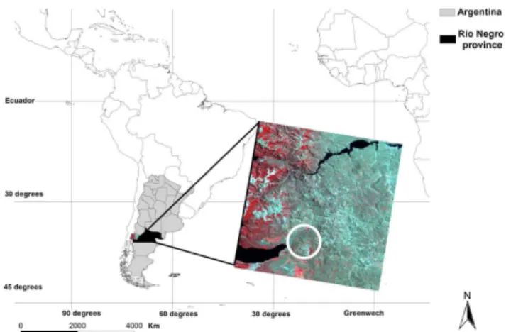
The study was carried out at the San Ram´on ranch, located 30 km east of Bariloche (R´ıo Negro province), NW Patag-onia, Argentina (41◦03′19′′S–71◦01′50′′W) (Fig. 1). This
23 846 ha ranch is situated in the Andean foothills and its main economic activity is livestock production. The climate is temperate with a Mediterranean precipitation regime, with 60% of precipitation occurring between May and August and mean annual precipitation of 580 mm. The mean annual temperature is 7◦C, with January (22◦C mean maximum
temperature) and July (−3◦C mean minimum temperature)
district (Cabrera, 1971; Le´on et al., 1998) that is charac-terised by tussock grasses. Stipa speciosa grassland domi-nates in the low sectors and Festuca pallescens grassland in the high sectors (Boelcke, 1957), with scattered shrubs of
Senecio bracteolatus, and Mulinum spinosum (Ghermandi et
al., 2004), leaving some areas covered by native shrublands of Fabiana imbricata and Discaria articulata (Anchorena et al., 1993; Anchorena and Cingolani, 2002). Incursions from the forest biome include upland types such as small patches of Austrocedrus chilensis. Patagonia grasslands are the most productive in the region, being widely used for forestry and stockbreeding. Grazing and fire are the more fre-quent grassland disturbances that strongly influence vegeta-tion dynamics in this area. In January 1999, a wildfire burned 17 500 ha (60% of the total ranch area) (Ayesa and Barrios, 1999), and quickly spread because of an exceptional 1998– 1999 drought, caused by a strong La Ni˜na event (National Weather Service, Climate Prediction Center). The study was conducted in two similar and nearby sites with different fire histories (here called fire and control). Concerning the “fire site”, two fire events are known, the oldest one occurred 36 years ago, whereas the second one occurred 10 years ago. It is also known that the 1999 fire (10 years ago) did not affect the “control site”.
2.2 Species description
Fabiana imbricata Ruiz et Pav´on (Solanaceae), is a native
evergreen shrub, characterised by its longevity (approx. 150 years) and which is 1.5–3 m tall. Its geographical distribution ranges from Mendoza to the center of Chubut in Argentina, and from Atacama to Valdivia in Chile. This species has stems with a high density of imbricata leaves and it has axil-lary flowers situated in axilaxil-lary or terminal branches. Its fruit is a septicide capsule of 6 mm which contains many reniform seeds of approx. 0.8–1.2 mm, which have a reticulate seed coat (Correa et al., 1971; Gonzalez, 2002). The flowering pe-riod extends from September to January. This species forms persistent seed pools in the soil (Gonzalez and Ghermandi, 2008) and its regeneration after a fire depends on seedling production (obligate seeder). The aerial parts of F. imbricata are used for medicinal purposes as a diuretic, digestive agent and to relieve kidney ailments (Razmilic et al., 1994) but it has no value as forage specie for cattle and sheep breeding. This species produce well-demarcated growth rings that can be easily identified (Barichivich et al., 2009).
2.3 Geoprocessing data
The 1999 fire-damaged area was determined by using TM satellite imagery processing (10 February 1999 Landsat 5 im-age, Path Row 232 88). Normal Burned Index (NBR) (Key and Benson, 1999) was tested to discriminate burned and un-burned areas. The NBR Index is defined as follows:
NBRi,j=(NB7i,j−NB4i,j)/(NB7i,j+NB4i,j) (1)
where NB7i,j and NB4i,j represent the values of the pixels i,j in the bands 7 and 4 of the Landsat TM images.
Global position system (GPS) was used for mapping the existing shrublands and to determine the vegetation pattern in the field in the two sites. The resulting data were then processed in the laboratory with GIS software (ArcGis). The determination of the vegetation pattern, the localization and the extension of the existing shrublands has been enabled by the use of GIS tools. The thematic layers of the existing shrublands were superimposed with the thematic layers of the shrublands previous to 1970 (San Ram´on vegetation map, Anchorena et al., 1993) by using GIS technology in order to estimate the temporal change in the shrublands location. Af-ter this, the 1999 wildfire data was also superimposed. All of the spatial data were then converted to the Gauss Kruguer (Zone 1) projection system, using the WGS84 system as a datum and ellipsoid of reference.
2.4 Dendroecological sampling and analysis
2.5 Landscape metrics
In order to identify the pattern generated by the patches in both sites, the data of the mapped shrubs were loaded in the GIS, calculating, at the same time, the characteristic mea-surements of the patches for each of the shrublands (Forman and Gordon, 1986). The indices measured were:
– A= Patch size (ha) – P = Perimeter (m2) – S= Patch shape index – I= Interior-to-edge ratio
where patch shape index and interior-to-edge (respectively) are defined as follows:
S=P /(2√π A) (2)
I=A/P (3)
3 Results
3.1 Geoprocessing data
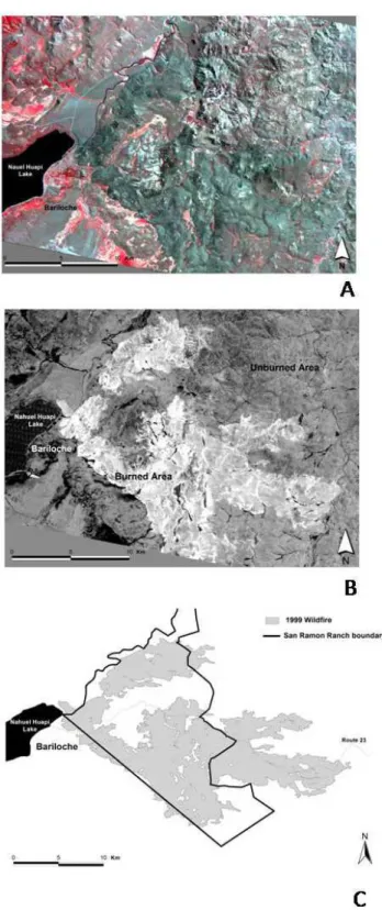
The NBR index was calculated on the Landsat TM image dating from 10 February 1999 (sixteen days after the out-break of fire), after it had been geometrically corrected. Fig-ure 2a shows the unprocessed image with a combination of bands 4, 3 and 2, whereas Fig. 2b exhibits the results ob-tained by the digital process. An adequate contrast between the burned and the unburned areas was generated in the im-age by the NBR index, allowing us to determine the burned area, which was then converted into a shape file data format and loaded to the GIS software (Fig. 2c).
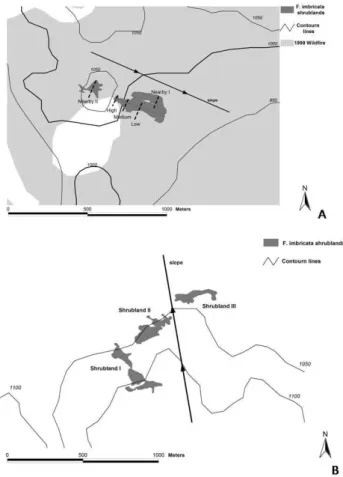
Data from those shrublands mapped with GPS, the area damaged by fire in 1999, as well as the contour lines, were superimposed in the GIS software. After this process, it was also possible to determine the shrublands location in both sites in relation to the 1999 fire and the land topography (Fig. 3). The shrubland orientation is parallel to the main ground slope (25%) in the “fire site”, being the lower part of the shrubland at an altitude of approximately 975 m a.s.l. and the higher part at an altitude of 1050 m a.s.l. On the other hand, two of the shrublands (Shrubland II and Shrubland III) show a tendency to be located parallel to the contour lines in the “control site”, whereas the remaining one (Shrubland I) borders a water course. Figure 4 shows each site in detail, while Fig. 5 the position of the rocky outcrop in relation to the shrublands – this is one of the main factors determining the fire behaviour in this region, as it acts as a natural fire break.
Fig. 2. Image digital processing. (A) Unprocessed Landsat TM
Fig. 3. Map of the area under study. This figure shows the mapped
shrublands, the area damaged by the fire of 1999, as well as the topography of both sampling sites.
Fig. 4. Map showing in detail the location of the shrublands under
study in relation to the 1999 fire and the topography. (A) Fire site.
(B) Control site (this site was undamaged by the fire in 1999).
Finally, those F. imbricata shrublands included in the veg-etation map of the ranch (Anchorena et al., 1993) (which was generated based on a series of aerial photographs dating from 1968), were also loaded to the GIS. Even though no
differ-Fig. 5. Spatial distribution of shrubs ages in both study sites. (A).
Fire site. (B) Control site.
ences can be found in the general location of the patches after comparing the shrublands existing in 1968 with the current ones in the sites under study, there is a shrubland patch, in the “fire site”, which is not present in the vegetation map of the ranch (Fig. 6a); in addition, an important difference can be observed in one of the shrublands in the “control site” (Fig. 6b).
3.2 Dendroecological analysis
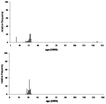
Figure 7 shows the age frequency distribution graphs for the shrubs sampled in both sites; while Tables 1 and 2 sum up the descriptive statistical parameters.
Fig. 6. Temporal change (1968–2009) in the F. imbricata
shrub-lands under study. (A) Fire site. (B) Control site.
Fig. 7. Frequency distribution of ages for shrubs sampled in the
both study sites. (A) Fire site. (B) Control site.
Table 1. Descriptive statistics of ages for both sampling sites and
for each sampling sub-site in the “fire site”.
Parameter Fire site Control site
mean 33.8 31.4 median 32 32 mode 33 32 s deviation 24.9 2.0 range 132 9 maximum 142 35 minimum 10 26
n 149 66
Parameter Low Medium High Shrubland Shrubland transect transect transect nearby 1 nearby 2
mean 31.2 32.7 125.8 10 10 median 32 33 140 10 10 mode 33 32 142 10 10 s deviation 2.6 0.8 23.3 0 0 range 14 2 50 0 0 maximum 35 34 142 10 10 minimum 21 32 92 10 10
n 111 10 8 10 10
medium transects), but in the remaining zone (high transect) next to the rocky outcrop (Fig. 5a), the age for most of the shrubs measured was around 142 years, indicating that the spatial configuration of age is closely associated to the close-ness to the rocky outcrop. On the other hand, in the “control site”, the age of all shrubs was around 32 years; no other shrub groups were found showing a different age. Figure 5 shows the spatial configuration of age in both sampling sites. 3.3 Landscape metrics
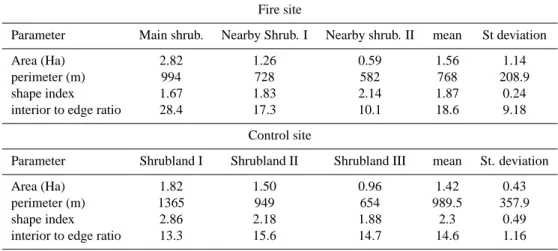
Table 2 sums up all landscape metrics used for the patches measured in both sites. No statistically significant differ-ences (α= 5%) were found between the fire and the “control site” in any of them. Mean values for the patch size were in the order of 1.56 ha for the “fire site”, and 1.42 ha for the “control site”, where all areas were more homogeneous than in the “fire site”. A different tendency is apparent for the patches perimeter, having a lower mean value and a lower deviation in the “fire site”. A higher medium value in the patch size and a lower perimeter renders the “fire site” with a lower interior-to-edge ratio (18.6 vs. 14.6).
4 Discussion
Table 2. Landscape metrics estimated for the studied Fabiana imbricata shrubland patches.
Fire site
Parameter Main shrub. Nearby Shrub. I Nearby shrub. II mean St deviation
Area (Ha) 2.82 1.26 0.59 1.56 1.14
perimeter (m) 994 728 582 768 208.9
shape index 1.67 1.83 2.14 1.87 0.24
interior to edge ratio 28.4 17.3 10.1 18.6 9.18
Control site
Parameter Shrubland I Shrubland II Shrubland III mean St. deviation
Area (Ha) 1.82 1.50 0.96 1.42 0.43
perimeter (m) 1365 949 654 989.5 357.9
shape index 2.86 2.18 1.88 2.3 0.49
interior to edge ratio 13.3 15.6 14.7 14.6 1.16
Fig. 8. Frequency distribution of ages for shrubs sampled in main
shrubland of the fire site. (A) Frequency distribution of ages for shrubs in the low transect. (B) Frequency distribution of ages for shrubs in the medium transect. (C) Frequency distribution of ages for shrubs in the high transect.
although it has scarcely been used in the Patagonian steppe region. The satisfactory result obtained by using the NBR in-dex in this study is in agreement with those reported by Bran et al. (2003), in a study in which this index had been used and which was carried out in northeastern Patagonia. The fire dating from 1999 in the San Ramon ranch has been, tak-ing its magnitude into account, one of the most conspicuous in the history of the region. The characteristics of the area burned by fire have been studied by several authors (Den-toni et al., 1999; Ayesa and Barrios, 1999) even though the analysis of those images was only visual, and no spectral in-dex was used. In that sense, this study complements the data obtained in previous studies, while offering good possibili-ties for further studies to evaluate and monitor fires in this region.
The dendroecological analysis enabled the determination of the areas which had been affected by fire in 1999 in the “fire site”. Here, the age of all shrubs sampled in the two nearby sites coincide with the period of time passed since the fire of 1999. This same analysis showed a unimodal fre-quency distribution, with low dispersion and being the statis-tics of central tendency, which estimate the age, grouped around 32 years for shrubs located in the lower and in the middle part of the slope of the main shrubland. The same pattern was found in the “control site”, which confirms that
F. imbricata regenerates after fire showing no recruitment of
Likewise, this study does not specify the type of fire and the conditions under which it developed, though it mentioned that it was a natural fire, with a decrease of 50% coverage and individuals of arboreal Berveris sp. and Maytenus boaria were severely affected and so we assume it was a wildfire of high severity. No satellite image can be found for that year to verify the fire occurrence, but the dendrocronological analy-sis, together with the above mentioned study, show that those sites were affected by the fire in 1978. The average age for shrubs analysed in the main shrubland in the high transect ranges from approximately 139 to 142 (with the exception of two being 92 and 100, respectively). The longevity of those shrubs and its spatial location on the rocky substrate indicate that F. imbricata is sheltered by the rocky outcrop from fire. These rocky outcrops are cited as shelters for plants and an-imals by many authors (Ward and Anderson, 1998; Douglas et al., 2000; Galende and Raffaele, 2007; Speziale, 2010). In the site under study, the area in which the high transect of the shrublands is located was called “Rocky/sheltered” by Anchorena and Cingolani (2002); besides, it is the habitat for isolated groups of dispersed individuals of Austrocedrus
chilensis, often multi-stemmed (Pastorino et al., 2004) and
scattered shrubs. The results obtained in this study could in-dicate that these zones can be considered as good shelters for F. imbricata when threatened by fire. According to this, there are no rocky outcrops bordering the shrubland in the “control site”, and the dendroecological analysis shows that there is only one age group in which no long-lived individ-uals were present; this could indicate that the site was uni-formly burned (having no sheltering areas). The spatial con-figuration showing a gradient of soil cover from the top to the bottom of the slope beginning with rocky outcrops, fol-lowed by Austrocedrus chilensis woody islands and ending in F. imbricata shrublands (Ghermandi et al., 2009) indicates that both the F. imbricata shrublands and the rocky outcrops act as natural fire breaks that shelter A. chilensis from fire. The results obtained in this study show no significant differ-ences in the patch metrics analyzed in both sites; however, further evaluation including more sampling sites is needed. The mean size of patches at both sites is very similar (1.56 at the fire site vs. 1.42 in the control site), while there seems to be major differences in the patches form (1.87 vs. 2.3 in shape index and 18.6 vs. 14.6 in the interior to edge ratio for fire site and control site, respectively). Size is a ma-jor variable that affects biomass, production and nutrient per unit area and species composition and diversity (Forman and Gordon, 1986). However, in this study, we found no evi-dence that the natural fires are related to the size of the patch. Also, the shape is one of the more important variables in the landscape because this is related to the patch’s edge effect. The patches’ edges play an important role in the ecosystem behaviour, as the environmental conditions and the species composition found there differ from those existing inside the patches (Forman and Gordon, 1986). With regard to fire, the fuel load produced in the patches’ edges and its influencing
area, is different from that which exists inside the patch and the surrounding matrix, and can determine the area, the size and the direction of the fire front (La Croix et al., 2008). Con-sequently, further research is needed to find out the relation-ship between the metrics of those patches of F. imbricata and environmental variables such as fire, topography and hydrog-raphy, in order to integrate these data with the establishment, expansion and the dynamic of this species. Both the shrub-land shape and the interior-to-edge ratio appear to be more closely related to the hydrography, the topography and the micro-topography than to the fire effect. The “Shrubland 1” borders the water course in the “control site”, with small de-viations which are produced by the soil micro-topography. The two remaining shrublands in this site (far away from the water course and having a smooth slope) are located parallel to the contour lines (see Fig. 4b). In the “control site”, the Main shrubland and the Nearby I present a longer shape and are orientated parallel to the steep slope of the ground (25%), which appears to influence their shape and location. On the other hand, the Nearby II shrubland, located in a place which is almost flat, the shape does not conform to any topographic pattern.
For instance, Anchorena and Cingolani (2002) have re-ported that F. imbricata was found bordering stream and wa-ter courses and, according to that study, this could be asso-ciated with the fact that this species is a facultative phreato-phyte. Regarding this, we believe that this pattern is gen-erated by the hydric dispersion of the seeds – as they are extremely small and without appendices and, therefore, they are not disseminated by the wind to farther distances. The post-fire recruitment of new F. imbricata individuals occurs when there is a wet spring after a fire (Ghermandi et al., 2010); accordingly, and as a consequence of the hydric con-ditions of soil bordering the streams, this species could gen-erate corridors like those normally seen in the area under study. Therefore, it is an important fact to take into account, as the dispersion has shown to be an essential factor in the spatial structure of communities (Heinz et al., 2005).
The integrated application of the tools used in this study, has made it possible to determine F. imbricata spatial dynam-ics of the analysed sites, showing the potential of these stud-ies at landscape scale, in relation to fire. Our results show, for this study area, that the population dynamics and the spa-tial configuration of F. imbricata are related to fire, but also to the soil topography and hydrography.
Acknowledgements. This research was funded by the Agencia de
Promoci´on Cient´ıfica y Tecnol´ogica -ANPCyT- (PICTO Forestal 36894 BID 1728). We thank Maximiliano Haidba˜ner (assisted in collecting field data), Andrew Hodgson (San Ram´on ranch manager), Norlan Tercero Bucardo (who has collaborated in the dendroecological analysis) and Ana Mar´ıa Rosa Montes who has helped with the English translation.
Edited by: R. Lasaponara
Reviewed by: M. J. Pastorino and another anonymous referee
References
Anchorena, J. and Cingolani, A.: Identifying habitat types in a dis-turbed area of the forest-steppe ecotone of Patagonia, Plant Ecol., 158(1), 97–112, 2002.
Anchorena, J., Cingolani, A. M., and Bran, D.: Mapa de vegetaci´on de Estancia San Ram´on, Comunicaci´on t´ecnica, 24, 63 pp., 1993. Ayesa, J. and Barrios, D.: Evaluaci´on del ´area afectada por incen-dios en la Estancia San Ram´on, Informe Tecnico INTA EEA, Bariloche, AR, 1999.
Barichivich, J., Sauchyn, D. J., and Lara, A.: Climate signals in high elevation tree-rings from the semiarid Andes of north-central Chile: responses to regional and large-scale variability, Palaeo-geogr. Palaeocl., 281(3–4), 320–333, 2009.
Bellingham, P. J. and Sparrow, A. D.: Resprouting as a life history strategy in woody plant communities, Oikos, 89(2), 409–416, 2000.
Boelcke, O.: Comunidades herb´aceas del norte de Patagonia y sus relaciones con la ganader´ıa, Rev. Inv. Agr., 11(1), 1–97, 1957. Bond, W. J. and Van Wilgen, B. W.: Fire and plants, Chapman &
Hall, 1996.
Bond, W. J. and Midgley, J. J.: The evolutionary ecology of sprout-ing in woody plants, Int. J. Plant Sci., 164(S3), 103–114, 2003. Bragg, T. B. and Hulbert, L. C.: Woody plant invasion of unburned
Kansas bluestem prairie, J. Range Manage., 29(1), 19–24, 1976. Bran, D., Cecchi, G., Ayesa, J., L´opez, C., Barrios, D., and Uma˜na, F.: Evaluaci´on y monitoreo de ´areas afectadas por grandes in-cendios en el NE de la Provincia de R´ıo Negro (Argentina) por medio de im´agenes SAC-C y Landsat-TM INTA, EEA Bar-iloche, Comunicaci´on T´ecnica de Relevamiento Integrado No. 82, 10, 2003.
Cabrera, A. L.: Fitogeograf´ıa de la rep´ublica Argentina, 1971. Cocke, A. E., Ful´e, P. Z., and Crouse, J. E.: Comparison of burn
severity assessments using Differenced Normalized Burn Ratio and ground data, Int. J. Wildland Fire, 14, 189–198, 2005. Correa, M. N., Barros, M., Nicora, E. G., and Cabrera, ´A.: Flora
patag´onica, Inta, 1971.
Chuvieco, E.: Teledetecci´on Ambiental, Ariel, Barcelona, 586 pp., 2002.
de Caso, M. I.: Efecto del fuego en los pastizales naturales patag´onicos, Tesis de Licenciatura, CRUB, Universidad Na-cional del Comahue, Bariloche, Argentina, 1984.
Dentoni, M. C., Defoss´e, G. E., Mu˜noz, M. M., Rodr´ıguez, N., and Colomb, H.: Estudio de Grandes Incendios: el caso de la Es-tancia San Ram´on, en Bariloche-R´ıo Negro, Argentina, Informe t´ecnico PNMF-CIEFAP-GTZ, 94 pp., 1999.
D´ıaz-Delgado, R. and Pons, X.: Spatial patterns of forest fires in Catalonia (NE of Spain) along the period 1975–1995 Analysis of vegetation recovery after fire, Forest Ecol. Manage., 147(1), 67–74, 2001.
Douglas, W., Matthes, U., and Kelly, P. E.: Cliff ecology: pat-tern and process in cliff ecosystems, Cambridge University Press, Cambridge, UK, 2000.
Epting, J., Verbyla, D., and Sorbel, B.: Evaluation of remotely sensed indices for assessing burn severity in interior Alaska us-ing Landsat TM and ETM+, Remote Sens. Environ., 96(3–4), 328–339, 2005.
Forman, R. and Godron, M.: Landscape ecology, Estados Unidos de Am´erica, John Wiley and Sons, 619 pp., 1986.
Frohn, R. C.: Remote sensing for landscape ecology: New metric indicators for monitoring, modeling, and assessment of ecosys-tems, CRC, 1998.
Gaitan, J. J., L´opez, C. R., Ayesa, J. A., Siffredi, G., Bran, D., and Uma˜na, F.: Caracterizaci´on y Cartograf´ıa de Valles y Mallines del Sudoeste de R´ıo Negro. Comunicaci´on t´ecnica, Area Recur-sos naturales, Relevamiento integrado 87, 2004.
Gajardo, J., Mena, C., Ormaz´abal, Y., and Morales, Y.: Cartograf´ıa local de ´areas quemadas empleando teledetecci´on, Ambiencia, 4, 107–122, 2008.
Galende, G. I. and Raffaele, E.: Space use of a non-native species, the European hare (Lepus europaeus), in habitats of the south-ern vizcacha (Lagidium viscacia) in Northwestsouth-ern Patagonia, Ar-gentina, Eur. J. Wildlife Res., 54(2), 299–304, 2008.
Ghermandi, L., Dudinszky, N., and Oddi, F.: Fabiana imbricata shrublands: natural firebreaks in the northwestern Patagonia?, European Geosciences Union, General Assembly 2009, Viena, Austria, 19–24 April 2009.
Ghermandi, L., Guthmann, N., Bran, D., and Collins, B.: Early post-fire succession in northwestern Patagonia grasslands, J. Veg. Sci., 15(1), 67–76, 2004.
Ghermandi, L., De Torres Curth, M. I., Franzese, J., and Gonza-lez, S.: Non-linear ecological processes, fires, environmental het-erogeneity and shrub invasion in northwestern Patagonia, Ecol. Model., 221(1), 113–121, 2010.
Gonzalez, S. and Ghermandi, L.: Postfire seed bank dynamics in semiarid grasslands, Plant Ecol., 199(2), 175–185, 2008. Haase, P.: An ecological study of the subalpine tree
Dracophyl-lum traversii(Epacridaceae) at Arthur’s Pass, South Island, New Zealand, New Zeal. J. Bot., 24(1), 69–78, 1986.
Heinz, K. S., Conradt, L., Wissel, C., and Frank, K.: Dispersal behaviour in fragmented landscapes: deriving a practical formula for patch accessibility, Landscape Ecol., 20(1), 83–99, 2005. Heisler, J. L., Briggs, J. M., and Knapp, A. K.: Long-term patterns
Heisler, J. L., Briggs, J. M., Knapp, A. K., Blair, J. M., and Seery, A.: Direct and indirect effects of fire on shrub density and above-ground productivityin a mesic grassland, Ecology, 85(8), 2245– 2257, 2004.
Heredia Laclaustra, A. H., S´anchez, S. M., Quintero, E., Pi˜neros, W., and Chuvieco, E.: Comparaci´on de distintas t´ecnicas de an´alisis digital para la cartograf´ıa de ´areas quemadas con im´agenes LANDSAT ETM+, GeoFocus, 3, 216–234, 2003. Johnson, E. A. and Gutsell, S. L.: Fire frequency models, methods
and interpretations, Adv. Ecol. Res., 25, 239–287, 1994. Keeley, J. E.: Seed Production, Seed Populations in Soil, and
Seedling Production After Fire for Two Congeneric Pairs of Sprouting and Nonsprouting Chaparal Shrubs, Ecology, 820– 829, 1977.
Keeley, J. E.: Utility of growth rings in the age determination of chaparral shrubs, Madrono, 40(1), 1–14, 1993.
Keeley, J. E., Fotheringham, C. J., and Baer-Keeley, M.: De-mographic patterns of postfire regeneration in Mediterranean-climate shrublands of California, Ecol. Monogr., 76(2), 235–255, 2006.
Key, C. H. and Benson, N. C.: Measuring and remote sensing of burn severity: the CBI and NBR, poster abstract, in: Proceedings Joint Fire Science Conference and Workshop, Vol. II, Boise, ID, 15–17 June 1999, edited by: Neuenschwander, L. F. and Ryan, K. C., University of Idaho and International Association of Wild-land Fire, 284 pp, http://jfsp.nifc.gov/conferenceproc/index.htm, 1999.
Kitzberger, T. and Veblen, T. T.: Fire-induced changes in northern Patagonian landscapes, Landscape Ecol., 14(1), 1–15, 1999. Kitzberger, T., Veblen, T. T., and Villalba, R.: Metodos
dendroe-cologicos y sus aplicaciones en estudios de dinamica de bosques templados de Sudamerica, Dendrocronologia en America Latina, 17–78, 2000.
Kitzberger, T., Raffaele, E., and Veblen, T.: Variable community re-sponses to herbivory in fire-altered landscapes of northern Patag-onia, Argentina, Afr. J. Range For. Sci., 22(2), 85–91, 2005. LaCroix, J. J., Li, Q., Chen, J., Henderson, R., and Ranjeet, J.:
Edge effects on fire spread in a disturbed Northern Wisconsin landscape, Landscape Ecol., 23, 1081–1092, 2008.
Le´on, R. J. C., Bran, D., Collantes, M., Paruelo, J. M., and Soriano, A.: Grandes unidades de vegetaci´on de la Patagonia extra andina, Ecolog´ıa Austral, 8(2), 125–144, 1998.
Miller, J. D. and Thode, A. E.: Quantifying burn severity in a het-erogeneous landscape with a relative version of the delta Normal-ized Burn Ratio (dNBR), Remote Sens. Environ., 109(1), 66–80, 2007.
Mitri, G. H.: An investigation in the use of advanced remote sensing and geographic information system techniques for post-fire im-pact assessment on vegetation, Metodol.Biomonitor Alterazione Ambientale, Trieste, Universit`a degli studi di Trieste, PhD XX Ciclo, 2007.
Morales, M. S., Villalba, R., and Boninsegna, J. A.: Climate, land-use and Prosopis ferox recruitment in the Quebrada de Humahuaca, Jujuy, Argentina, Dendrochronologia, 22(3), 169– 174, 2005.
Morgan, P., Hardy, C. C., Swetnam, T. W., Rollins, M. G., and Long, D. G.: Mapping fire regimes across time and space: under-standing coarse and fine-scale fire patterns, Int. J. Wildland Fire, 10(3/4), 329–342, 2001.
Pastorino, M. J., Gallo L. A., and Hattemer, H. H.: Genetic variation in natural populations of Austrocedrus chilensis, a cypress of the Andean-Patagonian Forest, Biochem. Syst. Ecol., 32, 993–1008, 2004.
Pickett, S. T. A. and White, P. S.: The ecology of natural disturbance and patch dynamics, Academic Press, 1985.
Razmilic, I., Schmeda-Hirschmann, G., Dutra-Behrens, M., Reyes, S., Lopez, I., and Theoduloz, C.: Rutin and scopoletin content and micropropagation of Fabiana imbricata, Planta Medica, 60, 140–140, 1994.
Ruete, A.: Arbustizaci´on en la estepa? Efectos de disturbios en la din´amica de matorrales de Fabiana imbricata en el noroeste de la Patagonia. Bariloche, Universidad Nacional del Comahue, 2006. Silva, J. M. N., S´a, A. C. L., and Pereira, J. M. C.: Comparison of burned area estimates derived from SPOT-VEGETATION and Landsat ETM+ data in Africa: Influence of spatial pattern and vegetation type, Remote Sens. Environ., 96(2), 188–201, 2005. Speziale, K. L., Ruggiero, A., and Ezcurra, C.: Plant species
rich-ness – environment relationships across the Subantarctic – Patag-onian transition zone, J. Biogeogr., 37, 449–464, 2010.
Stroppiana, D., Pinnock, S., Pereira, J. M. C., and Gregoire, J. M.: Radiometric analysis of SPOT-VEGETATION images for burnt area detection in Northern Australia, Remote Sens. Envi-ron., 82(1), 21–37, 2002.
Vaca, I. and De Montes, I.: Integraci´on de la ecolog´ıa del paisaje en la planificaci´on territorial: Aplicaci´on a la comunidad de Madrid, Madrid, Universidad Polit´ecnica de Madrid, 2006.
Veblen, T. T. and Lorenz, D. C.: Post-fire stand development of Austrocedrus-Nothofagus forests in northern Patagonia, Plant Ecol., 71(2), 113–126, 1987.
Veblen, T. T., Kitzberger, T., and Lara, A.: Disturbance and forest dynamics along a transect from Andean rain forest to Patagonian shrubland, J. Veg. Sci., 3(4), 507–520, 1992.
Veblen, T. T., Kitzberger, T., Villalba, R., and Donnegan, J.: Fire history in northern Patagonia: the roles of humans and climatic variation, Ecol. Monogr., 69(1), 47–67, 1999.