CITIZEN PARTICIPATION IN CITY PLANNING AND PUBLIC DECISION ASSISTED
WITH ONTOLOGIES AND 3D SEMANTICS
Thomas Panagopoulos; Centro de Investigação sobre Espaço e Organizações (CIEO), Universidade do Algarve, Campus de Gambelas, 8005-139, Faro, Portugal, email: [email protected]
Rita dos Reis Andrade; Faculdade de Ciências e Tecnologia, Universidade do Algarve, Campus de Gambelas, 8005-139, Faro, Portugal, email: [email protected]
Ana Paula Barreira, Faculdade de Economia, Universidade do Algarve, Campus de Gambelas, 8005-139, Faro, Portugal, email: [email protected]
ABSTRACT: Sustainable development of cities implies investigating cities in a holistic way taking into account many interrelations between various urban and environmental problems. Urban models are created with the objective of helping city planners and stakeholders in their decision-making processes. Models which represent in 3 dimensions the geometric elements of a city are called 3D city models. These models are increasingly used in different cities and countries for an intended wide range of applications beyond mere visualization. Such uses are made possible by adding semantics to the geometrical aspects, leading to semantically enriched 3D city models. This can be achieved by using the primary data and ontologies to achieve the semantic enrichment of 3D city models as well as their interoperability with other urban models. Objective of the paper is to present how semantically enriched 3D city models and ontologies may help in sustainable landscape city planning.
Keywords: “3D city models”, “semantic enrichment”, “urban ontology”, “interoperability”, “Geo-Information System”, “Knowledge Base”
INTRODUCTION
Recent studies see the city as a sustainable ecosystem where human needs have to be fulfilled while preserving the life support systems of the planet [1]. Complex interactions take place within cities and a holistic approach is mandatory to deal with urban issues in a sustainable way. This implies new tools and methods from various disciplines, with the aim of better integrating pieces of knowledge and presenting results in a way that allows decision-makers to carry out the best choices among different objectives and scales.
Long-term development in a volatile environment is a problem faced by almost every city. The strategy of urban development plays a key role in guiding the process of their development. However, there are so many factors affecting urban development, so it is very important to consider these complex factors comprehensively and develop a strategy consistent with the status of urban development.
In 1992 the United Nations Conference on Environment and Development focused world attention on the importance of sustainable management as a key component of sustainable development. The sustainability concepts of the Brundtland report demand the combination of ecological, economic, social and organizational
aspects of social development [2]. In this process, civil society organizations play a significant role in the mobilization of stakeholders for concrete projects in sustainable development and policy. In the 21st century, in our information era and knowledge-based society, the policy is designed, decided and implemented with a decision-making process that takes into consideration public participation and democratic governance.
In sustainable urban planning, public participation is seen as a means of achieving democratic decision through citizens’ involvement and public administration transparency. There is an increasing demand to develop interaction methodology and tools to support communication between authorities, citizens and concerned groups.
Meanwhile, sustainable urban design has become a major challenge for urban planners [3] and there is a requirement for computer-based tools which allow planners and designers to evaluate and analyze the environmental impacts of their proposed development. As an important component of landscape planning, visual impact assessment is mainly concerned with the direct impacts of the development upon views of the landscape through intrusion or obstruction, the reactions of viewers who may be affected and the overall impact on visual amenity [4].
The visual impact assessment should be made available for public review and demonstrate that
the proposed operations will achieve the visual quality objectives [5]. Most professionals in landscape reclamation use CAD software. Recent developments in computer network and communication show a lot of potential for supporting team design activities. Three-dimensional imaging for characterization of environmental sites is beneficial in perceiving the whole picture and in making better and quicker decisions because of the higher capacity in visualization and to facilitate this understanding new technologies, similar to that found in a flight simulator, were developed to help people visualize change [6].
In planning, decision making, and resource management geographic information systems (GIS) techniques has been known as one of the most advanced tools available to deal with complex problems, in particular with spatial dimensions, in a way of balancing the economic, environmental and societal objectives [7]. Integrating cityscapes in 3D GIS is not a new concept [8]. GIS was used by planners to assess the criteria requested to define the suitability of preserved landscape [9], to estimate changes in the visibility of land cover [10], to assess land-use impacts on biodiversity and conservation planning [11], in visual impact assessment and in urban landscape planning and design processes [12]. Public participation GIS (PPGIS) has emerged as a new research field to address public participation by using GIS. At the present time, most of researchers have focused on how to facilitate participants elicit preferences and propose solutions. However, they seldom include how to utilize participants’ feedbacks collected through PPGIS, in particular help the authorities/ decision makers to resolve the possible conflicts and build consensus among participants. Few projects addressed how to deal with public feedbacks in terms of analyzing data and providing continuous service.
The link of geographic information database systems with object-oriented computer assisted design has to be improved. GIS and environmental models are linked with computing architectures based on loosely coupled WEB geo-services [13]. However, these architectures fix mostly syntactic issues, but lack to address the semantic ambiguities and implicit details. A user needs detailed descriptions of the services, including the measurement units used, to discover the appropriate geo-service; thus these missing details hinder the discovery of geo-services. Some 3D city models have been recently created or are in the process of creation, but there is a real need to enrich current 3D city models so they can effectively deal with urban issues. Using
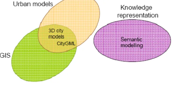
ontologies is an effective way to add rich semantics to current 3D city models (Fig. 1). Ontology is a term borrowed from philosophy that refers to the science of describing formal models that define concepts and their relationships within a scientific domain, such as urban planning, using mathematical logic.
Fig. 1. Ontologies as knowledge representation techniques used to integrate or interconnect urban data
and models with 3D city models.
Analogous to mathematical theory, an ontological concept denotes a collection of ‘instances’ that share common characteristics. Ontologies represent the underlying knowledge of some domain that we wish to represent for some purpose, namely the objects, concepts and other entities that are assumed to exist and the relationships that hold among them. Ontology modeling languages, such as the Web Ontology Language (OWL) [14] for the Semantic Web, are based on a subfamily of mathematical logic called ‘description logic’ [15, 16].
3D city models can be semantically enriched by integrating data from various urban issues including any useful non geometrical data such as social, legal or economic data. Using 3D city models makes possible simulations and evaluation of scenarios related to urban issues such as transportation, air quality or building energy consumption.
The public interested to such 3D city models is wide, including planners, designers, engineers, policy makers, authorities, decision-makers, citizens, investors and media. Also, the citizens of many communities are often the visionaries and are ahead of many government officials in their interest in developing sustainable landscapes [17]. It is crucial to give the opportunity to specialists and interested citizens to have a look on the results of the planned projects before their implementation starts [18]. The intended use is covering urban planning and design, preservation of historical buildings, infrastructure, promotion of economic development, and more. Using 3D city models, it is possible to visualize what a city will look like after a proposed change.
Current 3D city models are constructed from laser data, photos, maps, archives and databases containing location-based information (Fig. 2). These data become more commonly available as realtime visualization possibilities with free and 3D viewers such as Google Earth. Internet virtual reality projects will make possible to everyone to evaluate modifications in the landscape. Quick and original design of landscape reclamation projects using advanced 3D modelling techniques is essential.
Fig. 2. 3D city model from digital photos (source: Google earth).
Objective of the paper is to present how semantically enriched 3D city models and ontologies may help in sustainable landscape city planning with public participation.
METODOLOGY
Geospatial conceptual data models represent semantic information about the real world that will be implemented in a spatial database. When linked to a repository, they offer a rich basis for formal ontologies. Several spatial extensions have been proposed to data models and repositories in order to enrich the semantics of spatial objects, typically by specifying the geometry of objects in the schema and sometimes by adding geometric details in the repository.
In that context, the paper will explore new approaches for urban planning by combining Virtual Environments and Simulations to address sustainability issues. These approaches are based on the possibilities of reconstructing 3D models of the built environment using digital photographs [19]. The 3D models can then be combined with simulations in order to address sustainable urban development issues (Fig. 3).
Fig. 3. Example of semantic enrichment of 3D city models of air quality.
The City Geography Markup Language (CityGML) is the new and innovative concept for the modelling and exchange of 3D city and landscape models that will be used at the project. CityGML is an information model for the representation of 3D urban objects. It defines the classes and relations for the most relevant topographic objects in cities and regional models with respect to their geometrical, topological, semantical and appearance properties. Included are generalization hierarchies between thematic classes, aggregations, relations between objects, and spatial properties. In contrast to other 3D vector formats, CityGML is based on a rich, general purpose information model in addition to geometry and graphics content that allows employing virtual 3D city models for analysis tasks in different application domains like simulations, urban data mining, facility management, and thematic inquiries.
CityGML is realised as an open data model and XML-based format for the storage and exchange of virtual 3D city models. It is implemented as an application schema for the Geography Markup Language version 3.1.1 (GML3), the extendible international standard for spatial data exchange issued by the Open Geospatial Consortium (OGC) and the ISO TC211 [20]. CityGML does not only represents the graphical appearance of city models but especially takes care of the representation of the semantic properties, taxonomies and aggregations of Digital Terrain Models, sites (including buildings, bridges, tunnels), vegetation, water bodies, transportation facilities, and city furniture.
The AristotelsViewer will be used to evaluate new features for the 3D models. The AristotelesViewer was developed to visualize, edit and update 3D data given as GML data. It enables users and developers not only to visualize the scene, but
also to gain access to given semantics or metadata provided with the 3D models (Fig. 4). Afterwards it will be examined a framework for annotation. The CREAM framework (Creating RElational, Annotationbased Metadata), will be used because allows for relational metadata, defined as “annotations which contain relationship instances”. Relational metadata is essential for constructing knowledge bases which can be used to provide semantic services [21].
Fig. 4. Interoperability of semantic enrichment of 3D city models of air quality.
The annotation framework needs guidance from ontology. In order to allow for sharing of knowledge, newly created annotations must be consistent with the ontologies. To edit the urban ontologies will be used Protégé which is a free, open source ontology editor and knowledge-base framework. Protégé ontologies will be exported into a variety of formats including RDF(S), OWL, and XML. Protégé is based on Java, is extensible, and provides a plug-and-play environment that makes it a flexible base for rapid prototyping and application development. The Protégé editor is an extension of Protégé that supports the Web Ontology Language (OWL). OWL is the most recent development in standard ontology languages for Semantic Web vision. An OWL ontology may include descriptions of classes, properties and their instances. The OWL formal semantics specifies how to derive its logical consequences, i.e. facts not literally present in the ontology, but entailed by the semantics.
The Protégé editor enables users to:
Load and save OWL and RDF ontologies. Edit and visualize classes, properties, and
SWRL rules.
Define logical class characteristics as OWL expressions.
Execute reasoners such as description logic classifiers.
Edit OWL individuals for Semantic Web markup.
This work will improve the quality of public participation through incorporating PPGIS with decision making techniques, including Analytic Hierarchy Process (AHP) and Multi criteria decision analysis (MCDA). Integrating with GIS, the conventional decision making techniques will be extended to deal with issues with geographical dimensions as well as conflict resolution among a great number of participants. The work concentrates on the methods and models that could be applied to facilitate public elicit preference as well as support authorities to achieve group consensus.
This work aims at building an integrated public participation platform providing decision support to participants i.e. citizens, concerned groups and local authorities through the planning process (Fig. 5).
1. For the participants i.e. citizens, stakeholders etc. by combing GIS visualization and MCDA, provide participants acceptable approaches to elicit preference through selecting and weighting criteria.
2. For the authorities i.e. government agencies or other decision makers, by developing methods and tools to support local authorities to deal with public feedbacks including participants pattern analysis, public concerns identification, participants difference measurement, conflict resolution by using Multi Participants Multi Criteria decision making techniques. Help decision makers achieve public agreement based on participants’ opinions according to different democratic rules. 3. For concerned groups, by publishing citizens’ opinions together with GIS-based analysis functions as Web services. The concerned groups e.g. NGOs could have opportunities to approach and analyze public concerns and develop more applications from non-governmental perspective. Finally, a prototype system will be established to apply the proposed methods and models. From technology perspective, Google map together with ESRI family of products could be used to develop the prototype system. Ajax (Asynchronous JavaScript and XML), GeoRSS (Geographically Encoded Objects for RSS feeds) and Plone (open source content management system) could play of importance roles. A Web-based geo-referenced communication platform will be established by using googlemap API, where information with reference to geographical locations could be shared and exchanged between participants and authorities.
CONCLUSION
Our general conclusion is that providing semantic annotation, relational metadata in particular, is an important complex task that needs comprehensive support. Semantic enrichment of 3D city models still need further refinement, but they are unique in their design and implementation.
Information aggregation and presentation for decision processes, should further investigated. Usability assessment of 3D city models has to be explored.
The present work expects to improve local urban design projects development mainly in the urban details. Within the broader concept of sustainability the project expects to become a platform to address questions related with local XXI agendas, generating a channel for at a small-scale direct democracy practice.
An ontology-based system may improve the communication and interoperability of urban planning projects. Computer simulations such as digital fly-over videos may help in 3D imaging and characterization of the landscape. The presented ontology based system could help planners, and any other citizen interested in the design of sustainable cities with aesthetic and social value. It also could enrich the decision-making process and help governmental officials to take the appropriate decision: accept, reject or suggest modifications in any proposed rehabilitation project.
References
[1] Newman, P., Jennings, I. (2008), Cities as Sustainable Ecosystems. Principles and Practices. Island Press, Washington.
[2] Brundtland, G.H. (1987), Our common future Oxford University Press, New York.
[3] Yao, R., Steemers, K., & Li, B. (2006), Sustainable urban and architectural design. Chine Architecture and Building Press.
[4] Nicholson D.T. (1995), The visual impact of quarrying. Quarry management, 22(7):39-42. [5] Lucas O.W. (1991), Design of forest landscapes.
British forestry comition. Oxford University Press, New York.
[6] Ard R.H. (2000), 3D In-Context Visualization Supports Both ESRI GIS and CAD; Improves Communication During the Development Approval Process. Proceedings of the Twentieth Annual ESRI User Conference
[7] Panagopoulos, T., Antunes, M.D.C. (2008), Integrating geostatistics and GIS for assessment of erosion risk on low density Quercus suber woodlands of South Portugal. Arid Land Research and Management 22(2), 159-177.
[8] Luca L., Veron, P. Florenzano, M. (2006), Reverse engineering of architectural buildings based on a hybrid modeling approach. Computers & Graphics 30 160–176.
[9] Florent J.M., Musy T.A. (2001), Using GIS and outranking multicriteria analysis for land-use suitability assessment. Intern. J. of Geographical Information Science, 15:153-174.
[10] Koomen, E., Kaufholz, R., Rietveld, P., & Scholten, H. (2004), 3D-GIS and urban volume: Applying the third dimension in a morphological study of the Amsterdam urban landscape. In proceedings of the seventh AGILE conference on geographical information science (pp. 139–147).
[11] Theobald D.M., Hobbs N.T., Bearly T., Zack J.A., Shenk T., Riebsame, W.E. (2000), Incorporating biological information in local land-use decision making: designing a system for conservation planning. Landscape Ecology, 15:35–45.
[12] Kodmany A.K. (2000), GIS in the Urban Landscape: reconsfiguring neighbourhood planning and design processes. Landscape Research, 25:5– 28.
[13] ArcWeb, (2006), Environmental Systems Research
Institute. (ESRI), Redlands USA.
www2.arcwebservices.com/v2006/index.jsp. [14] McGuinness, D.L. and Van Harmelen, F. (2004)
OWL Web ontology language overview. W3C Recommendation (http://www.w3.org/TR/owl-features
[15] Baader, F. (2003), The Description Logic Handbook: Theory, Implementation, and Applications, Cambridge University Press.
[16] Sowa, J.F. (2000), Knowledge Representation: Logical, Philosophical, and Computational Foundations, Brooks Cole Publishing Co., Pacific Grove, CA, USA.
[17] Panagopoulos, T., Vargues, P.M. (2006), Visual impact assessment of a golf course in a Mediterranean forest landscape. In Lafortortezza, L and Sanesi, G.(eds.) Patterns and Processes in Forest Landscapes, Consequences of Human Management. Accademia Italiana di Scienze Florestali, Firenze, Italy, pp. 279-285
[18] Ramos, B., Panagopoulos, T. (2007), Integrating aesthetic and sustainable principles in stream reclamation projects. WSEAS Transactions on Environment and Development, 3, 189-195. [19] Pons, J.P. and Soubra S. (2008), 3D reconstruction
of large scale city models as a support to sustainable development. CDVE 2008, Y. Luo (Ed.) pp. 172–175, Springer-Verlag Berlin.
[20] Isikdag, U., Underwood J. and Aouad G. (2008), An investigation into the applicability of building information models in geospatial environment in support of site selection and fire response management processes. Advanced Engineering Informatics 22: 504–519.
[21] Uren, V., Cimiano, P., Iria, J., Siegfried, H., Vargas V.M., Motta, E. Ciravegna Fabio. (2006), Semantic
annotation for knowledge management:
Requirements and a survey of the state of the art. Web Semantics: Science, Services and Agents on the World Wide Web, 4: 14–28.
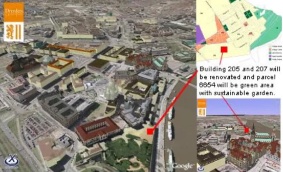
Fig. 5. Ontology-based links in the interface. Example for Dresden 3D city adapted form Google earth. The solid rectangles visually interconnect representations of the same building in different views