University of Minho
School of Engineering Department of Informatics
Bruno Daniel Mestre Viana Ribeiro
Platooning Simulation
in ITS Communications
University of Minho School of Engineering Department of Informatics
Bruno Daniel Mestre Viana Ribeiro
Platooning Simulation
in ITS Communications
Master dissertation
Engineering of Computer Networks and Telematic Services Dissertation supervised by
Prof. Alexandre Santos Prof. Maria Jo˜ao Nicolau
Acknowledgments
This research work would not have been possible without the help of many people, for their support and valuable contributions.
I would like to express my appreciation and sincere thanks to my supervi-sors from University of Minho, professupervi-sors Alexandre Santos and Maria Jo˜ao Nicolau. I am very grateful for their great effort in giving me useful advices and guidance throughout the development of my thesis.
I would also like to thank all my colleagues from Algoritmi Center at Uni-versity of Minho for their support, in particular to F´abio Gon¸calves for his truly valuable input and interesting discussions on Platooning.
I must express my gratitude to my parents and family for their inexhaustible support and endless encouragement throughout my life.
And last, but not least, a very special word of appraise goes to my girlfriend Raquel for her patience and for being supportive during the most stressful times.
Part of this research has been sponsored by the Portugal Incentive System for Research and Technological Development. Project in co-promotion no 002797/2015 (INNOVCAR 2015-2018).
Abstract
Vehicular Ad Hoc Networks (VANETs) is a term used to describe networks of moving vehicles equipped with devices that allow spontaneous commu-nication with other vehicles and infrastructures. Developing collaborative driving applications for VANETs is currently a hot topic and has an increas-ing popularity in the Intelligent Transportation Systems (ITS) domain. The goal of this thesis is to study the development and testing of advanced ITS applications, using Platooning as a use case. It presents a state of the art on typical ITS applications, its evaluation and corresponding implementa-tion and testing methods. The Platooning Management Protocol (PMP) was then implemented and tested by means of simulation, resorting to the V2X Simulation Runtime Infrastructure (VSimRTI) framework, which cou-ples Simulation of Urban MObility (SUMO) and Network Simulator 3 (ns-3). Results show that it is able to work in a smooth and efficient manner: the ma-neuvers happen during an acceptable interval, the proposed communication requirements are met and the lane capacity is increased.
Resumo
Vehicular Ad Hoc Networks (VANETs) ´e um termo usado para descrever redes de ve´ıculos em movimento, equipados com dispositivos que permitem uma comunica¸c˜ao espontˆanea com outros ve´ıculos e infraestruturas. Desen-volver aplica¸c˜oes de condu¸c˜ao colaborativa para VANETs ´e atualmente um t´opico muito estudado e cuja popularidade tem crescido no dom´ınio dos In-telligent Transportation Systems (ITS) - sistemas de transporte inteligentes. O objetivo desta tese ´e o estudo, desenvolvimento e teste de aplica¸c˜oes de ITS avan¸cadas, utilizando Platooning como caso de uso. Neste documento ´e ap-resentado o estado da arte relativo `as aplica¸c˜oes ITS tipicamente avaliadas e os respetivos m´etodos de implementa¸c˜ao e teste. O Platooning Management Protocol (PMP) foi implementado e testado atrav´es de simula¸c˜ao, utilizando a ferramenta V2X Simulation Runtime Infrastructure (VSimRTI), que acopla as ferramentas Simulation of Urban MObility (SUMO) e Network Simulator 3 (ns-3). Os resultados mostram que o protocolo funciona de forma leve e efi-ciente: as manobras decorrem num intervalo de tempo aceit´avel, os requisitos de comunica¸c˜oes s˜ao cumpridos e a capacidade das faixas ´e aumentada.
Contents
1 Introduction 1
1.1 Background . . . 2
1.1.1 Intelligent Transportation Systems . . . 2
1.1.2 ITS Applications . . . 5
1.1.3 Advanced ITS Applications . . . 7
1.2 Thesis Objectives . . . 9 1.3 Thesis Outline . . . 10 2 Related Work 11 2.1 Related Literature . . . 11 2.2 Related Projects . . . 16 2.3 Summary . . . 18 3 ITS Simulation 19 3.1 Simulation Tools . . . 20 3.1.1 Network Simulation . . . 20 3.1.2 Traffic Simulation . . . 21 3.1.3 Coupled Simulation . . . 23 3.2 Summary . . . 24
4 ITS Applications Taxonomy 25 4.1 Application Taxonomy . . . 25
4.2 Platooning Use Case . . . 34
4.3 Platooning Management Protocol . . . 36
4.3.2 Platooning Requirements . . . 45 5 Simulation Deployment 49 5.1 Deployment Decisions . . . 49 5.2 Simulation Scenario . . . 52 5.3 Messages . . . 79 5.3.1 Common . . . 80 5.3.2 Join . . . 81 5.3.3 Leave . . . 82 5.3.4 Merge . . . 82 5.4 Implementation Challenges . . . 84
6 Results and Analysis 87 6.1 Lane Capacity . . . 88 6.2 Maneuvers . . . 90 6.2.1 Join Maneuver . . . 90 6.2.2 Leave Maneuver . . . 91 6.2.3 Adjusting Gaps . . . 92 6.2.4 Merge Maneuver . . . 92 6.2.5 Dissolve . . . 93 6.3 Messages . . . 94 6.4 Distances . . . 96 6.5 Speed . . . 98
List of Figures
1.1 Vehicle Communication Modes [1] . . . 3
1.2 A classification of the existing ITS applications [2] . . . 6
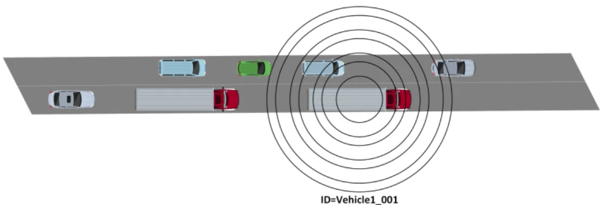
4.1 Platoon of vehicles . . . 34
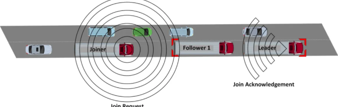
4.2 Create maneuver . . . 37
4.3 Join maneuver - Steps 1 and 2 . . . 39
4.4 Join maneuver - Step 3 to 6 . . . 39
4.5 Join maneuver - Step 7 and 8 . . . 39
4.6 Join maneuver - Final state . . . 39
4.7 Dissolve maneuver - Step 1 . . . 40
4.8 Dissolve maneuver - Step 2 . . . 40
4.9 Dissolve maneuver - Step 3 . . . 41
4.10 Dissolve maneuver - Final State . . . 41
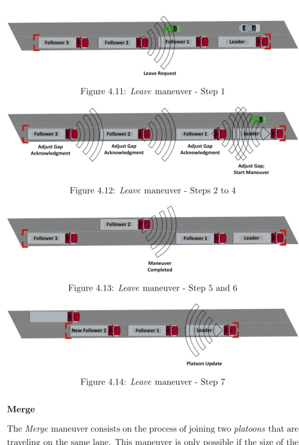
4.11 Leave maneuver - Step 1 . . . 42
4.12 Leave maneuver - Steps 2 to 4 . . . 42
4.13 Leave maneuver - Step 5 and 6 . . . 42
4.14 Leave maneuver - Step 7 . . . 42
4.15 Leave maneuver - Final State . . . 43
4.16 Merge maneuver - Steps 1 and 2 . . . 44
4.17 Merge maneuver - Step 3 . . . 44
4.18 Merge maneuver - Steps 4 to 6 . . . 44
4.19 Merge maneuver - Steps 7 and 8 . . . 44
4.20 Merge maneuver - Final State . . . 45
5.1 Scenario Maps . . . 53
5.3 Leader Vehicle 0 creates platoon A . . . 59
5.4 Vehicle 1 sends a Join Request towards Vehicle 0 . . . 61
5.5 Vehicle 0 acknowledges the Join Request from Vehicle 2 and sends a Adjust Gap message to Vehicle 1 . . . 63
5.6 Vehicle 1 informs the Leader that has reached the correct ad-justing position . . . 64
5.7 Vehicle 2 reaches the correct joining position and sends a Dis-tance Achieved message towards Vehicle 0 . . . 64
5.8 Leader Vehicle 0 sends a Start Maneuver message to Vehi-cle 2. When the VehiVehi-cle 2 informs that the maneuver is com-pleted, Vehicle 0 sends Platoon Updated messages to the string, and the platoon reaches a stable state - String is now composed of [Vehicle 0, Vehicle 2, Vehicle 1 ] . . . 65
5.9 Vehicle 3 awaiting instructions from Vehicle 0 . . . 67
5.10 Leader Vehicle 4 acknowledges the Join Request from Vehi-cle 6 and then proceeds to reject the request from VehiVehi-cle 7 (maximum string size is achieved) . . . 68
5.11 Platoon B stabilized after the Join maneuvers from Vehicle 5 and Vehicle 6 - String is now composed of [Vehicle 4, Vehi-cle 6, VehiVehi-cle 5 ] . . . 68
5.12 Leave Maneuvers I . . . 69
5.13 Leave Maneuvers II . . . 70
5.14 Vehicle 8 joins Platoon B at the rear . . . 71
5.15 Stabilized Platoons . . . 71
5.16 Vehicle 4 (Leader B) sends a Merge Request geocast message . 73 5.17 Vehicle 4 (and Platoon B ) approaching Platoon A . . . 74
5.18 Merge maneuver final state - Platoon A is now composed of [Vehicle 0, Vehicle 1, Vehicle 3, Vehicle 4, Vehicle 6, Vehicle 8 ] 75 5.19 Vehicle 8 Leave maneuver . . . 76
5.20 Stabilized Platoon A - [Vehicle 0, Vehicle 1, Vehicle 3, Vehi-cle 4, VehiVehi-cle 6 ] . . . 77
6.1 Lane Capacity during simulation time . . . 89 6.2 Mean message delivery delay values for each simulation . . . . 96 6.3 Vehicle’s distance to go value during simulation . . . 97 6.4 Vehicle’s speed value during simulation . . . 99
List of Tables
4.1 ITS applications and their communication requirements [3] . . 27
4.2 Basic Set of Applications (BSA) Definition [4] . . . 29
4.3 Requirements of Intelligent Transportation Systems (ITS) use cases [4] . . . 30
4.4 General requirements for applications [5] . . . 31
4.5 European Telecommunications Standards Institute (ETSI) ap-plications according to CAR2CAR classification . . . 32
4.6 Applications Requirements Summary . . . 33
4.7 Potential Wireless Communication Technologies for ITS Ap-plications . . . 34
4.8 Platoon Maneuvers Requirements . . . 46
5.1 Vehicle colors in Simulation of Urban MObility (SUMO) . . . 59
6.1 Mean capacity values during simulation runtime . . . 89
6.2 Join maneuver duration . . . 90
6.3 Rejected Join Request duration . . . 91
6.4 Leave maneuver duration . . . 92
6.5 Adjusting Gap durations . . . 93
6.6 Merge maneuver duration . . . 93
6.7 Dissolve maneuver duration . . . 94
6.8 Statistic results from messages latency of the first simulation run . . . 94
Acronyms
ACC Adaptive Cruise Control
AES Advanced Encryption Standard
ARC Adaptive Route Change
BSA Basic Set of Applications
C2C TMC to TMC
CACC Cooperative Adaptive Cruise Control
CAM Cooperative Awareness Message
CanuMobiSim CANU Mobility Simulation Environment
CDG Constant Distance Gap
CEN European Committee for Standardization
COLOMBO Cooperative Self-Organizing System for low Carbon Mobility at low Penetration Rates
COMPANION Cooperative Dynamic Formation of Platoons for Safe and Energy-Optimized Goods Transportation
CTG Constant Time Gap
DCC Decentralized Congestion Control
DSRC Dedicated Short-Range Communications
DynB Dynamic Beaconing
Energy ITS Development of Energy-Saving ITS Technology
ETSI European Telecommunications Standards Institute
EWA Emergency Warning Application
GCDC Grand Cooperative Driving Challenge
GLOSA Green Light Optimized Speed Advisory
GPS Global Positioning System
GTNetS Georgia Tech Network Simulator
GUI Graphical User Interface
HMI Human-Machine Interface
I2C Infrastructure to TMC
I2I Infrastructure to Infrastructure
I2V Infrastructure to Vehicle
iCS iTETRIS Control System
IEEE Institute of Electrical and Electronics Engineers
iGAME Interoperable Grand Cooperative Driving Challenge AutoMation Experience
IP Internet Protocol
ISO International Organization for Standardization
iTETRIS Integrated Wireless and Traffic Platform for Real-Time Road Traffic Management Solutions
ITS Intelligent Transportation Systems
JiST Java in Simulation Time
JiST/SWANS Java in Simulation Time/Scalable Wireless Ad-Hoc Net-work Simulator
MiXiM Mixed Simulator
MOTO Mobile Opportunistic Traffic Offloading
MOVE MObility model generator for VEhicular networks
NHTSA National Highway Traffic Safety Administration
ns-2 Network Simulator 2
ns-3 Network Simulator 3
OBUs On-Board Units
OEM Original Equipment Manufacturer
OMNeT++ Objective Modular Network Testbed in C++
OSM OpenStreetMap
PATH Partners for Advanced Transportation Technology
PER Packet Error Rate
PHEM Passenger Cars and Heavy Duty Emissions Model
PMP Platooning Management Protocol
RSA Rivest-Shamir-Adleman
RSUs Roadside Units
SARTRE Safe Road Trains for the Environment
SHA-256 Secure Hash Algorithm - 256
SUMO Simulation of Urban MObility
SWANS Scalable Wireless Ad-Hoc Network Simulator
TCP Transmission Control Protocol
TMC Traffic Management Center
TraCI Traffic Control Interface
TSIS-CORSIM Traffic Software Integrated System - Corridor Simulation
V2C Vehicle to TMC
V2I Vehicle to Infrastructure
V2V Vehicle to Vehicle
V2X Vehicle to Anything
VANETs Vehicular Ad Hoc Networks
VCS Vehicular Communication Systems
VEINS Vehicles in Network Simulation
VENTOS VEhicular NeTwork Open Simulator
VISSIM Verkehr In Stadten SIMulationsmodell
VSimRTI V2X Simulation Runtime Infrastructure
Chapter 1
Introduction
According to some researches [6] [7], it is expected that global Vehicle to Anything (V2X) communication modules in new vehicles will reach 62% and that Original Equipment Manufacturer (OEM) and aftermarket V2X mod-ules will grow to 423 million by 2027. Cadillac recently announced [8] that we should expect Vehicle to Vehicle (V2V) technology in 2017 Cadillac CTS. Toyota has already introduced vehicle-infrastructure communication systems in 2015 car models [9]. These are just some examples of the current state of vehicle communications in the automotive industry.
Vehicles equipped with communication capabilities may be able to exchange important information that can help prevent accidents, save lives, ease traffic flow or even improve the environment. Vehicles that are connected require very efficient and smooth Vehicular Communication Systems (VCS), essen-tially due to the very short delays that this type of connection depends upon (specially when the communication concerns the safety of the drivers). Some communication systems that may be adopted are traditional 3G/4G cellular or Wi-Fi, or specially designed systems like Dedicated Short-Range Communications (DSRC) or ITS G5. Cellular networks are typically applied in Vehicle to Infrastructure (V2I) solutions, whereas ad hoc networks are practically the only technology considered in V2V communications [10]. Intelligent Transportation Systems (ITS) are systems consisting of an intri-cate set of technologies applied to vehicles and infrastructures that ensure an
efficient and smart usage of the roads in general. They allow the control of traffic operations and even influence drivers behavior. These systems have the potential to improve safety, efficiency and productivity or even decrease levels of pollution.
ITS enable the rise of several applications relying on the exchange of infor-mation between vehicles themselves and infrastructures, allowing drivers to either manually or automatically make smarter driving choices. These appli-cation range from simple appliappli-cations such as Emergency Vehicle Warning to more advanced and complex solutions like Platooning.
There are two main approaches when assessing vehicular networks applica-tions (with different benefits and drawbacks): through simulation or field operational trials. Simulation allows the control of scenario parameters and the replication varying conditions, but its development is a challenging task. Field operational trials allow a realistic evaluation of systems but they are very expensive and possess serious safety and also technological constraints.
1.1
Background
This section provides an overview on the background of the project and its context. It contains a description of ITS and how the communication work on these systems, and a complete review on ITS applications and use cases, including advanced applications.
1.1.1
Intelligent Transportation Systems
ITS are defined by the European Parliament [11] as systems in which in-formation and communication technologies are applied in the field of road transport, including infrastructure, vehicles and users, traffic management and mobility management, as well as for interfaces with other modes of transport. There are a wide range of ITS applications, such as road safety applications, traffic efficiency and infotainment.
The ITS standards [12] are defined so that one can establish and enable interoperability, by specifying who communicates with whom (e.g. vehicle,
road-side infrastructure, etc.) and what type of messages must be used, which protocol (e.g. Internet Protocol (IP)) should be used and in which communication media (e.g. wireless frequency band), etc.
Since the regularity constrains differ from region to region (even country to country), there are several ITS standards developing organizations: Insti-tute of Electrical and Electronics Engineers (IEEE) and Society of Automo-tive Engineers (SAE) in the USA, European Committee for Standardization (CEN), International Organization for Standardization (ISO) and ETSI in Europe, etc.
Vehicle Communications
Luca Delgrossi states [1] that the idea of vehicle communication is that ve-hicles, roadside infrastructure (roads and highways), and back-end (telecom-munications and Internet backbones) work together.
VCS are networks where vehicle’s On-Board Units (OBUs) and Roadside Units (RSUs) work as communicating nodes that share information with each other, like traffic information or safety warnings. Since VCS use a co-operative approach, accidents and traffic congestions avoidance can become more effective than by using the traditional way (where vehicles try to solve problems by themselves). Figure 1.1 illustrates how typical vehicle commu-nication modes work. Below are described V2V modes of commucommu-nication.
V2V Local Broadcast In V2V Local Broadcast, a vehicle disseminates mes-sages to all other vehicles that are within the respective communication range. This communication mode is used to support cooperative appli-cations, mostly aimed to prevent collisions. This messages are used to inform nearby cars of current position, speed and such. However, due to the highly dynamic nature of traffic flow, the set of neighbors (vehicles) changes frequently. Thus, short range radios with native broadcasting capabilities are the best way to support this mode.
V2V Multi-Hop Dissemination In V2V Multi-hop Dissemination, mes-sages from a given vehicle are relayed by others in order to reach vehicles that are out of the source’s communication range. This mode may be used to support hard safety applications, but only if the number of hops is very low.
Infrastructure Communications
The following subsection describes how V2I and Infrastructure to Vehicle (I2V) communications work.
I2V Local Broadcast Vehicles receive local broadcasts from the roadside infrastructure (e.g. Poor road conditions information or traffic con-troller information). I2V Local Broadcast can be implemented through the use of radio transceivers deployed along the roadside. It may also be implemented by using other strategies like cellular or satellite services, etc.
V2I Bidirectional Communications V2I Bidirectional Communications are required by a lot of mobility and convenience applications. Some examples are Internet access navigation and media download. V2I Communications can also be used to broadcast messages from a vehicle to other vehicles through the applications servers infrastructure. This mode can be supported by either using short range or long range radios.
Additionally, it is possible for infrastructures to communicate with each other (Infrastructure to Infrastructure (I2I)) - this mode is mostly used for relaying
information.
Traffic Management Center Communications
The Traffic Management Center (TMC) is used for monitoring and control-ling traffic and the road network. There are three communication modes available for TMC: Vehicle to TMC (V2C), Infrastructure to TMC (I2C) and TMC to TMC (C2C). Through this communications, it is able to moni-tor the surrounding environmental conditions and manage the transportation resources in order to provide support for a better traffic flow (e.g. keep traffic moving safely after traffic incidents).
1.1.2
ITS Applications
ITS applications are developed to optimize driver safety and comfort. Vehicle communications bring a lot of benefits to users, such as improved safety for the driver (with solutions like Situation Awareness, Collision Avoidance or Post-crash Assistance), enhanced driving experience (e.g. Navigation, Rout-ing, Points of Interest ) or extended connectivity (office activity available in the car), etc. Given the wide range of existing (and upcoming) applications, one of the most critical tasks is to standardize the diverse communication requirements for each type of application.
Vehicle Communications Applications are typically divided [2, 13, 14] in two main categories: safety and non-safety. Figure 1.2 illustrates an example of how ITS applications can be described, according to [2].
The non-safety applications can be divided in two subcategories: Mobility (Efficiency) and Comfort (Connectivity and Convenience). Mobility appli-cations focus mainly in improving and managing the traffic flow. Resorting to live traffic updates, route guidance, navigation and such, traffic behavior can in fact be enhanced. These applications provide updated local infor-mation, maps and information of relevance, in order to improve the traffic flow, coordination and assistance. This type of traffic applications is typi-cally used in V2I scenarios. Connectivity and Convenience applications are more focused in assuring that the driving experience is more pleasant and
Figure 1.2: A classification of the existing ITS applications [2]
enjoyable to the driver. They provide functionalities needed by passengers and drivers for a convenient travel. They offer a wide range of features like email, media, access to social networks, etc. These applications are often delivered through the use of electronic devices (most of times through the driver’s smartphones) or in-vehicle devices. These applications may tolerate some delays but can also occasionally have a high data throughput demand. Connectivity and Convenience applications are also referred to as in-car com-fort entertainment - they do not use inter-vehicular communications in most
situations.
Safety applications can also be sub-divided [15, 16] in two kinds: Soft Safety and Hard Safety. Soft Safety applications mean to increase drivers safety but, since they do not require immediate attention, they are less time-critical. They notify the driver of not so imminent dangers like icy roads, traffic jams, reduced visibility, etc. Usually, the typical driver reaction to this notifica-tions is to proceed more carefully or to take an alternate route. On other hand, Hard Safety applications are used to prevent accidents or, at least, minimize the severity if the crash is unavoidable. Thus, this kind of applica-tions requires a minimum communication latency and high reliability when delivering messages, so that the driver can react in time. Forward Collision Warning and Emergency Electronic Brake Light are examples of Hard Safety applications. Safety applications rely on real-time information and typically resort to V2V communications. They are used to avoid traffic accidents. Vehicles and RSUs share information that is used to predict dangerous situ-ations.
1.1.3
Advanced ITS Applications
ITS applications vary from basic management systems (such as car naviga-tion and variable message signs) to more advanced applicanaviga-tions that rely on real time live information and feedback from surrounding sources. These kind of advanced solutions aim to provide innovative services, enabling the users to use the network in a more informed and coordinated way. Two very important advanced ITS applications that are heavily researched by the community are vehicle Platooning and Cooperative Adaptive Cruise Control (CACC). Platooning is defined as a set of vehicles connected via wireless communication that travel in conjunction and in formation, coordinated by a leader vehicle. The lead vehicle is responsible for general cooperative ac-tions such as steering or braking and it is assumed that the leading driver must possess proper training to control a platoon. This solution allows the following drivers to perform tasks that otherwise were not advised to be per-formed (e.g. use a phone) while their vehicles are being controlled based on
sensor information. Still, these drivers must be able to control the vehicle if, for some reason, the platoon is dissolved or no longer controlled by the lead -deciding if it is safer to remain in the platoon or to drive manually becomes a challenge for every following driver. This way of traveling introduces many benefits such as increased road capacity, fuel efficiency and enhanced safety (fewer traffic collisions). There are several projects focused on the concept of Platooning, such as SARTRE [17], COMPANION [18] and i-GAME [19]. The CACC application is an evolution from the Adaptive Cruise Control (ACC) application that resorts to V2V communication to enable the ex-change of useful information to and from neighbor vehicles. CACC is a system for vehicles that automatically adjusts the traveling speed to main-tain a safe distance from vehicles ahead. Besides allowing a vehicle’s cruise control to maintain a proper distance to the following car, it also allows them to communicate between each other and cooperate in an adaptive mode. The neighbor’s information on acceleration is typically transmitted using CAM messages from the Wireless Access in Vehicular Environments (WAVE) tech-nology. More than providing the driver with a more comfortable experience, CACC has the potential of improving traffic safety and efficiency. The ulti-mate goal of ITS applications is to reach the point of full autoulti-mated driving and these applications are the next step towards it. Automated driving is the enabling key to eliminate the potential errors made by humans in trans-portation systems. Future driver-independent systems will result in fewer accidents, traffic jams and even lower emissions.
These two application have been often mistaken in recent years and assumed to be the same. Although both applications are part of a broader class of automatic vehicle control systems, there are important differences between them. The first difference is that CACC only controls longitudinal distance (the driver is responsible for steering and monitor the vehicle) while Platoon-ing is capable of controllPlatoon-ing both longitudinal and lateral distances. Also, according to SAE [20] and National Highway Traffic Safety Administration (NHTSA) [21], CACC will fit on a lower level of automation when comparing to Platooning.
control strategies. Platooning solutions typically resort to a Constant Dis-tance Gap (CDG) strategy, coupling vehicles very close to each other with a constant distance, ignoring the vehicles velocity. With this approach, vehicles give the illusion of a chain link. This solution requires a very strict control mechanism and is not very tolerable to disrupt communications due to secu-rity issues - if communication fails during an emergency maneuver, following drivers may not be able to react in time in these very short distances. In other hand, CACC typically uses the Constant Time Gap (CTG) strategy, which is similar to human driver behavior. In this approach, the distance between vehicles depends on the vehicles speed - the distance is proportional to the speed.
1.2
Thesis Objectives
The development of advanced applications is currently a hot topic and is becoming more and more popular in the ITS field of work. The primary goal of this thesis is to develop and test advanced ITS applications, using Pla-tooning as use case. ITS applications will be tested by means of simulation. The primary goal may be divided in sub-goals, listed as follows:
• Study the ITS applications development state of the art;
• Survey the existent VANETs simulation tools;
• Build a taxonomy for ITS applications, including a Platooning use case;
• Analyze and test the Platooning Management Protocol (PMP), includ-ing descriptions on the application behavior and maneuvers;
• Design and build the simulation environment;
1.3
Thesis Outline
The Introduction chapter has already presented a summary about the context in which this work has arisen and its objectives. The remaining thesis is structured as follows. Chapter 2 provides an overview on the related work and literature. Chapter 3 introduces the characteristics of simulation tools. Chapter 4 addresses the ITS applications, in particular the Platooning use case, presenting the design of the PMP. Chapter 5 presents the process of evaluating the performance of the application. Chapter 6 debates the results obtained from the simulation runs. Finally, Chapter 7 provides the main achievements and future research directions.
Chapter 2
Related Work
This related work review chapter is essentially divided in two parts. The first part intends to provide a brief overview on available publications that cover subjects related to V2X applications, with special attention to advanced ap-plications (e.g. Platooning and CACC). Although essentially focused on V2X applications simulation, it presents some important work that describes sys-tems designs, implementations, communication strategies and so on. The second part discusses some important projects/consortium that have similar goals and aims regarding advanced applications in Vehicular Ad Hoc Net-works (VANETs). Not being practicable to introduce all the related projects existent, the main focus has been directed into funded projects, looking into their main objectives and results.
2.1
Related Literature
Milan´es et al. [22] present the design, development, implementation and test-ing of a CACC system. The design of the system is based on controllers that determinate the maneuvers in the platoon: the leader vehicle approaching maneuver and the car-following regulation maneuver. The solution aims to reduce significantly the gaps between the vehicles, taking advantage from information exchanged using DSRC wireless communication. In order to ex-periment its performance against the commercially available ACC, the system
was implemented and tested on four Infiniti M56s vehicles, in three different scenarios: The first evaluated the behavior of the following cars when the gap settings are changed, the second tested cut-in and cut-out situations and the third compared the CACC performance of the vehicles following a speed change profile with the performance of the traditional ACC system. The authors conclude that the system performed well and was able to reduce the gap variability and handle the cut-in and cut-out situations. Additionally, the CACC improved the response time and platoon stability, when in com-parison to the ACC system, proving that the system may be able to improve traffic flow and capacity.
Katsaros et al. [23] propose an implementation of a Green Light Optimized Speed Advisory (GLOSA) application, and evaluates its performance us-ing the V2X Simulation Runtime Infrastructure (VSimRTI) simulation tool. Their goal was to measure the GLOSA effect on fuel and traffic efficiency, resorting to average fuel consumption and average stop time behind a traffic light metrics. The GLOSA application consists in providing the vehicles ac-curate traffic lights information (using I2V communication), and giving them speed advice, in order to assure a more fluid speed with less stopping time. To test the application, an urban area traffic scenario with a single route and two traffic lights was defined, using the SUMO tool. The simulations had different penetration rates of equipped vehicles and traffic density. The authors conclude that the system could in fact improve the fuel consumption and traffic congestion levels and that the higher the penetration rate is, the more benefits the application can provide, specially in high density scenarios. Bergenhem et al. [24] survey the state of the art and present an overview of projects related to vehicle Platooning that took place at the time the article was written - Safe Road Trains for the Environment (SARTRE), Partners for Advanced Transportation Technology (PATH), Grand Cooperative Driving Challenge (GCDC), Development of Energy-Saving ITS Technology (Energy ITS) and SCANIA platooning project. They conclude their work with a sum-mary and comparison between the different projects using the following pa-rameters: vehicle type, automatic control direction, requirements/potential changes to infrastructure, integration, mainly used primary onboard sensors
and the main goals of the project regarding Platooning.
Guvenc et al. [25] present the Team Mekar’s CACC implementation at the GCDC. They show both experimental and simulation results, discussing the challenges found. Their CACC implementation was based on V2V communi-cation - exchanging information about the Global Positioning System (GPS) position and velocity, and preceding vehicle acceleration data, resorting to IEEE 802.11p WAVE protocol. The scenarios included both a traffic light and an urban environment.
Katsaros et al. [26] evaluate the impacts of a GLOSA application imple-mentation on efficiency of traffic in urban areas and present its performance resorting to the VSimRTI tool, with Java in Simulation Time/Scalable Wire-less Hoc Network Simulator (JiST/SWANS) and SUMO simulators. Ad-ditionally, they also study the behavior of the Adaptive Route Change (ARC) application (route alternation through V2I/V2V communication). The met-rics used to analyze the applications were average fuel consumption, average stop time behind a traffic light and average trip time. The authors defined different urban scenarios that included traffic lights, using different penetra-tion rates of vehicles running the applicapenetra-tions, vehicles that complied to the recommended speed and traffic density. Their results show that this systems could in fact improve fuel consumption levels and also reduce traffic jams and trip time.
Segata et al. [27] analyze the interference of non-automated vehicles, when a given vehicle is joining a platoon. They define a protocol that supports the join maneuver, and validate it using the Platooning extension (Plexe [28]) from Vehicles in Network Simulation (VEINS), showing if a maneuver can be performed with success or safely aborted. Furthermore, they analyze the impact of the Packet Error Rate (PER) on the maneuver’s rate of success. The results show that their protocol can support complex joining maneuvers and that the dangerous maneuvers can be safely aborted. Additionally, they conclude that platoons remain stable even with high loss rates and that ma-neuvers are aborted only when networking conditions are bad (PER larger than 10%).
IEEE 802.11p communication, including three basic maneuvers (along with commands to accomplish them). These maneuvers enable several operations such as joining and leaving the platoon. The protocol was implemented in the VEhicular NeTwork Open Simulator (VENTOS) simulation platform (which couples SUMO and Objective Modular Network Testbed in C++ (OMNeT++) simulators) and tested in different scenarios and settings (in-cluding platoon communication structure, inter-platoon spacing, time-gap and size). To build a better model, they also implemented a more complex longitudinal control system in SUMO. They conclude that the protocol is able to ensure a stable traffic flow and theoretical throughput. The protocol is also able to react to loss in communication, either by using retransmissions or downgrading to ACC mode.
Aissaoui et al. [30] propose a real-time traffic monitoring system that aims to enhance typical reliability, accuracy, and granularity levels, providing infor-mation to vehicles with the lowest overhead possible. To accomplished that, they propose a cluster solution, where only the cluster head (the one respon-sible for providing RSUs the data about all vehicles in the cluster) updates the information. To evaluate the system, they used the Network Simulator 3 (ns-3) version made available by the Integrated Wireless and Traffic Plat-form for Real-Time Road Traffic Management Solutions (iTETRIS) platPlat-form (which combines ns-3 and SUMO simulators). They conclude that by using this mechanism it is possible to reduce overhead to one quarter when in com-parison to typical approaches, while gathering more than 99% of the existent data.
Bellavista et al. [31] work focus on the implementation and evaluation of pro-tocols that arisen from the COLOMBO project, developed on the iTETRIS platform. In particular, the COLOMBO project aimed to develop local-based cooperative protocols that determine traffic characteristics without the need to communicate with global data centers. COLOMBO aspired to achieve accurate traffic estimations with low penetrations rates of V2X technology equipped vehicles. In this paper, they describe how they implemented the protocols on the platform, together with the learned lessons. The results from the simulations (based on real traffic traces and a real topology) prove
the feasibility of the proposed approach (even with low penetration rates). Segata et al. [32] investigate communication strategies for Platooning and compare the proposed approaches to two beaconing protocols that have been designed for cooperative awareness applications: Decentralized Congestion Control (DCC) and Dynamic Beaconing (DynB). The simulation models were validated and parameterized based on real world experiments. To estab-lish the comparison between the approaches they resorted to PLEXE, which is based on the VEINS tool. Their goal was to evaluate the performance and behavior of the protocols under ”stressful” configurations, regarding the networking and application perspectives. The obtained results show the pro-tocols can greatly improve the performance, both in the application and network layers.
Goebel et al. [33] introduce a trace-based simulation tool chain for V2X ap-plications resorting to cellular networks and real world traces as a basis, assuring that some unpredictability present in other simulation approaches is minimized. To prove their concept, they used the VSimRTI framework (coupling SUMO and OMNeT++ simulators) to compare the performance of the ETSI defined Emergency Warning Application (EWA) against their optimized version. The results show that the developed version is superior in its performance.
Fazio et al. [34] propose an application that aims to advise danger on emer-gency situations on VANETs resorting to V2V and V2I message exchanges working on top of the IEEE 802.11p standard. To perform an evaluation on the application, the authors executed simulations on various scenarios, in order to retrieve general information that is independent form the sce-nario. The selected framework was VSimRTI, which permitted the coupling of the SUMO and JiST/SWANS simulators. From the obtained results, they proved that the proposed emergency management application is able to im-prove the reaction for general vehicles and emergency ones. The designed solution allows vehicles (communicating with the WAVE protocol) to update their path in order to avoid traffic jams near accidents, saving time for reach-ing their destinations. It allows for emergency vehicles to intervene in less time, managing the accident in a better and safer way, since it also brings
benefits to the injured people, which can be treated faster (the emergency vehicle average speed is higher when running the application). Additionally, the normal traffic flow can also be restored in less time. The application ben-efits are proportional to the number of vehicles running the application. The application tends to achieve better results in the suburbs, since the roads are more sparse than the central ones.
Krajzewicz et al. [35] evaluates the simulation of the GLOSA application (in-cluded in BSA), measuring its effects on traffic efficiency and predicting the results on real-world environments. The GLOSA system suggests vehicles a speed that will allow them to pass the traffic lights when they are green. To evaluate the system, the simulations were performed using SUMO together with a communication model coupled via Traffic Control Interface (TraCI). The main goal of the work was to validate the developed simulation models capabilities. The authors conclude that GLOSA helps in fact vehicles to go through the network, although some vehicles do not need to halt at all and some have to stop (which is assumed to happen due to receiving the traffic lights states too late). The evaluations shown that increasing the number of vehicles reduces the application benefits (even with all vehicles equipped).
2.2
Related Projects
Cooperative Dynamic Formation of Platoons for Safe and Energy-Optimized Goods Transportation (COMPANION) [18] is an ongoing European project that aims to develop co-operative mobility solutions for Platooning, in order to enhance fuel efficiency and safety [36]. They intend to develop and validate a system that is able to form, create and manage platoons. In particular, they expect to create both off-board and on-board coordination and interface solutions and analyze the legislative conditions of Platooning. Finally, the last objective is to demonstrate the validity of the system in proper tracks and through simulation.
Interoperable Grand Cooperative Driving Challenge AutoMation Experience (iGAME) [? ] is an ongoing European project that aims to speed real-life implementation and interoperability of automated driving via wireless
com-munication. Its goals is to design a functional architecture and requirements for automated driving, and demonstrating its validity in a multi-vendor chal-lenge. Additionally, they aim to create a control system, an interaction pro-tocol for cooperative applications, tools used for validation and verification, and to standardize interaction messages. The project also specifies scenarios and the needed requirements (functional, communication, etc.).
SARTRE [17] is a project funded by the European Commission that aimed to develop Platooning solutions, with significant environmental, safety and comfort benefits. SARTRE defines Platooning as a set of vehicles driving together with a lead vehicle (driven by a professional) and several followers fully automatically, with short gaps between them. The project investigated the human and safety factors of Platooning. To prove the concept, they developed a system with a lead truck, a following truck, and 3 following cars. Additionally they developed a solution to help vehicles find and join a suitable platoon, but this solution was not integrated in the system. The system was tested on specific tracks in order to measure the fuel consumption benefits. Finally, they studied the commercial viability of the product, in-frastructure and environmental concerns, and defined recommended policies to achieve a wider impact.
Cooperative Self-Organizing System for low Carbon Mobility at low Pene-tration Rates (COLOMBO) project [37] aimed to overcome the problem of most cooperative systems requiring high penetration rates of equipped ve-hicles for their functionality to be assured. The project’s main goal was to design traffic management components that enable the correct functioning of the system with penetration rates below 10%. The key objectives were to de-crease costs and vehicular emissions. The researchers focused on two topics: traffic surveillance (determine the traffic state by collecting data from V2X messages) and traffic light control algorithms (making traffic lights adjust according to the traffic state). As part of the results, the project concludes that the self-organizing traffic control algorithm performs well even with very low penetration rates (1%), based on the metrics of waiting time, number of stops per vehicle in intersections and the emission levels. Additionally, they made available and public a series of open source software and simulation
scenarios. In particular, they developed extension for commonly used tools such as iTETRIS, SUMO, ns-3 and the Passenger Cars and Heavy Duty Emissions Model (PHEM).
There are also other relatively relevant projects that deserve a mention, such as KONVOI [38], CHAUFFEUR II [39], Energy ITS [40], Mobile Opportunis-tic Traffic Offloading (MOTO) [41] or Partners for Advanced Transportation Technology (PATH) [42], but detailed descriptions have been omitted here.
2.3
Summary
This chapter presented an overview on related work regarding ITS applica-tions (including advanced applicaapplica-tions) and on important projects/consor-tium relative to the same field of study.
Most related literature that aims to analyze the behavior of a given applica-tion or soluapplica-tion (e.g. GLOSA, CACC, Platooning, etc.) tends to resort to simulation using frameworks such as VSimRTI and VEINS to evaluate their performance. However, there are several works that test the solutions in experimental environments, which potentially present more accurate results. Related work focus mostly on information and solutions related to CACC and Platooning, including full-system designs, communication performance analysis or even state of the art surveys.
The related projects focus on advanced applications, giving special emphasis to Platooning, which is currently a very hot topic in the research community.
Chapter 3
ITS Simulation
The development of efficient VANETs advanced systems or applications re-quires the determination of the main system properties and consequent eval-uation of its performance. Performing field tests in vehicular environments is a tough challenge for a series of reasons. The large number of existent vehicles and traffic scenarios makes it very difficult to collect data in the periments. Moreover, the development of real prototypes is usually very ex-pensive and they take too much time to be prepared and processed. In other hand, resorting to simulations is a popular solution when it comes to evaluate the performance of transportation and communication systems. When using simulation tools, researchers are able to control parameters, configurations, conditions and input data, which are major advantages. Furthermore, tests can be easily accomplished and repeated, and using widely known tools does not require researchers to validate individual models, allowing them to focus only on developing solutions. Although both solutions (testbed and simula-tion) allow the study of the system, simulation is able to perform assessments in a larger scale. However, the simulation method normally assumes the use of simpler models, which may reduce the system realism - the accuracy of their implementation may affect the results veracity. In summary, simulating VANETs brings benefits in terms of cost, repeatability, scale and practical requirements. For this reason, researches tend to resort to simulation rather than field testing.
3.1
Simulation Tools
To perform a proper simulation of VANETs, both a traffic and a network simulator are required, although they may work independently. The aim of this section is to identify and describe the most widely used tools and frameworks when performing VANETs simulations. First, some important networks simulators are presented, followed by traffic simulators and finally also some important platforms/tools that integrate both traffic and networks simulators.
3.1.1
Network Simulation
Network simulation is one of the most prominent evaluation methods in com-puter networks. This method is commonly used for developing new commu-nication protocols and architectures.
Network Simulator 3 (ns-3) [43] is a well-known discrete event simulator for communication networks that evolved from Network Simulator 2 (ns-2) [44]. This evolution brought several improvements such as scalability and memory usage - ns-3’s design incorporated architectural concepts from Georgia Tech Network Simulator (GTNetS) [45], known for being a simulator with good scalability. ns-3 supports realistic models of wireless communications for co-operative ITS applications - it provides models to emulate radio propagation effects and functionalities and protocols for all layers of the ITS-G5 stack. The Objective Modular Network Testbed in C++ (OMNeT++) [46] open source tool is an extensible, component-based C++ discrete event network simulator, known for scaling well for large networks. Although not provid-ing any specific components for computer network simulations, these mod-els are developed independently - its user community has provided support mainly for standard wired and wireless IP networks. OMNet++ has two main frameworks that benefit from a specially designed propagation model for V2X: Mixed Simulator (MiXiM) [47] and INET Framework [48].
Java in Simulation Time (JiST) [49] is a discrete event simulation engine written in Java, that allows the simulation of real Java applications. Al-though allowing general purpose network simulation, it is commonly used
together with Scalable Wireless AdHoc Network Simulator (SWANS) [49] -a highly sc-al-able mobile -ad hoc networks simul-ator, th-at is -able to simul-ate scenarios of more than ten thousand nodes. Unfortunately, the official de-velopment of JiST is no longer mantained, and the latest version does not include neither mobility nor propagation models for VANETs.
3.1.2
Traffic Simulation
Traffic simulation tools emulate the traffic flow in transportation networks. Traditionally, traffic simulators can be classified as microscopic, macroscopic, and mesoscopic, depending on the granularity: microscopic simulators model traffic at a large scale, treating each entity (e.g. cars, trains) individually; macroscopic tools are used to model traffic at a large scale, treating traffic like a fluid; mesoscopic simulation combines the properties of both micro-scopic and macromicro-scopic simulation models, describing the reality in terms of aggregated traffic platoons of vehicles characteristics, avoiding the time and complexity issues of implementing microscopic scenarios. However, VANETs scenarios required accurate models of communication between nodes and their exact position, which make both macroscopic and mesoscopic not so reliable solutions since they offer less detail when in comparison to micro-scopic simulations.
Simulation of Urban MObility (SUMO) [50] is an open source and highly portable microscopic simulator widely used for VANETs research and typ-ically used to simulate automatic driving or traffic management strategies [51]. It possesses several features such as large road networks, collision free vehicle movement, different vehicle types, single-vehicle routing, multi-lane streets with lane changing, etc. Additionally, SUMO includes a visualizer that shows the road topology and nodes movement during the simulation runtime. It is possible to combine SUMO with OpenStreetMap (OSM) [52] and simulate traffic in any location in the world. Unfortunately, SUMO is a pure traffic generator, which means that the traces generated by the tool cannot be easily used by network simulators (in a direct way). The TraCI API existent in SUMO allows it to act as a server and connecting to an
ex-ternal application using a Transmission Control Protocol (TCP) socket. MObility model generator for VEhicular networks (MOVE) [53] is a realistic mobility models generator that is built on top of SUMO. MOVE generates mobility traces with data from realistic vehicles movements that can later be used in other network simulators (e.g. ns-2). Additionally, MOVE provides a Graphical User Interface (GUI) that allows an easy way to generate sce-narios.
Verkehr In Stadten SIMulationsmodell (VISSIM) [54] is a multi-modal mi-croscopic, time-step and behavior-based traffic simulation tool. VISSIM is considered a leader in the field of micro-simulation software. It is a frame-work that provides a powerful GUI that allows users to define maps and scenarios, and the traffic conditions can be visualized in a very high level of detail. This tool implements a car-following traffic model that takes into consideration psychological aspects of drivers. Additionally, it also provides a pedestrian mobility model, which sometimes is useful in urban scenarios. It is able to analyze traffic under constraints such as lane configuration, speed limits, traffic signals, and so on. VISSIM allows the following types of traffic to be simulate: vehicles (cars and trucks), trams, buses, bicycles, motorcy-cles, pedestrians and even rickshaws.
VanetMobiSim [55] is an extension for the CANU Mobility Simulation Envi-ronment (CanuMobiSim) [56], a flexible framework that is used for modeling mobility. CanuMobiSim is able to generate trace files in different formats, supporting different mobility simulation software. VanetMobiSim provides vehicular mobility, with both microscopic and macroscopic realistic vehic-ular movement models. At macroscopic level, it supports multi-lanes, bi-directional flows, differentiated speed constraints and traffic signs. At mi-croscopic level, VanetMobiSim implements V2V and V2I models that enable vehicles to regulate speed, overtake maneuvers and respecting traffic signs in intersections. VanetMobiSim mobility models have been validated by the well known Traffic Software Integrated System - Corridor Simulation (TSIS-CORSIM) [57] traffic generator.
3.1.3
Coupled Simulation
Although mobility and network simulators work in an independent way, there are some tools that allow their interconnection, which enables them to in-teract with each other. These systems are usually of type: i) isolated, ii) federated or iii) integrated. In i) isolated solutions, the mobility tool gen-erates a trace file which is later processed by the network simulator. In ii) federated mode, the simulators communicate through a two-way interface: the network simulator controls the traffic simulator through commands and the traffic tool reports back information about the vehicles (e.g. position). In the iii) integrated mode, a single simulator handles both traffic and network simulation simultaneously.
Vehicles in Network Simulation (VEINS) [58] is an open source framework that provides a control interface between SUMO and OMNeT++ via TCP sockets. VEINS framework development was based on MiXiM. The com-munication between the simulators (network and mobility) is accomplished though the use of SUMO’s TraCI. Both simulators are bidirectionally cou-pled and run in parallel, which means traffic has direct impact on network performance and vice versa. In this framework, the OMNeT++ simulator is directly extended - it is able to control and send commands to vehicles directly (e.g. orders to change speed or path). VEINS contains modules that implement the IEEE 802.11p standard and the higher layer of the DSRC stack.
Integrated Wireless and Traffic Platform for Real-Time Road Traffic Man-agement Solutions (iTETRIS) [59] is an open source simulation platform developed under the European FP7 Program and it is characterized by a modular architecture that allows the integration of two widely used traffic and wireless simulators (SUMO and ns-3), and supports the implementation of cooperative ITS applications in various programming languages. iTETRIS implements a new central block called iTETRIS Control System (iCS). The iCS handles the SUMO and ns-3 interaction, in addition to preparing, trig-gering, coordinating and controlling the execution of simulations. The mod-ularity of iTETRIS source code allows the coupled use of other open source
simulators, without having to modify their internal modules.
V2X Simulation Runtime Infrastructure (VSimRTI) [60] is a general frame-work for the evaluation of VANETs solutions that is able to couple different simulators each for a particular domain (networking and mobility). The VSimRTI modules are responsible for handling all the management tasks -time synchronization, interaction, communication, data exchange and so on. The integration of simulators is enabled by the implementation of generic VSimRTI interfaces. This framework provides also a simple network and a cellular communication simulator, a Java-based application simulator, and a battery simulator. Additionally, it provides visualizer and analysis tools. Furthermore, VSimRTI is being extended to enable the simulation of electric mobility environments.
3.2
Summary
The increasing popularity of VANETs lead the research community to de-velop accurate and realistic simulation tools for these environments. Given the fact that test fielding in VANETs is a tough challenge, researches resort to the use of simulation tools to evaluate the performance of applications, communication systems and so on.
This chapter reviewed some basic general aspects of ITS simulation and sur-veyed the most prominent tools available to perform network, traffic and cou-pled simulations. Regarding networking, the ns-3 and OMNeT++ are tools widely used and validated by the research community, while JiST develop-ment is no longer maintained. In traffic and mobility simulation, SUMO is a very popular solution that has proved its reliability and performance within the ITS community. Although not as strong as SUMO, VanetMobiSim is also often used for modeling mobility in VANETs. For these reasons, it is quite natural that most coupled frameworks tend to resort to the use of these powerful simulators, in order to render the simulation results as accurate as possible when comparing to real life.
Chapter 4
ITS Applications Taxonomy
Considering the availability of a wide range of applications (with their corre-sponding requirements), it is important for the research community to estab-lish reference values for the requirements of each type of existing applications and use cases. This chapter presents an overview of the related work and a summary of the main aspects that build a taxonomy of applications. Fur-thermore, this chapter introduces a detailed description of the Platooning use case and presents the proposed Platooning Management Protocol (PMP).
4.1
Application Taxonomy
Regarding the related work of characterizing applications, L`ebre et al. [61] introduce concepts and specific vocabulary in order to classify current inno-vations or ideas on the emerging topic of smart cars. They organized the solutions according to their societal and scalable evolution.
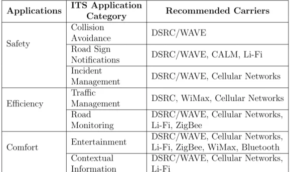
Dar et al. [2] summarize the communication characteristics and features of typical applications from the three main types (Safety, Efficiency and Com-fort ). Additionally, they provide a mapping methodology that allows to select for each class of applications a suitable communication media.
Papadimitratos et al. [62] summarize the state-of-the-art solutions (avail-able at the time) from a broad range of projects, and present a represen-tative list of vehicle applications and their requirements. The applications
names are closely compatible with those used by projects such as Car2Car Communication Consortium (C2C-CC) [63], SAFESPOT [64] or Cooperative Vehicle-Infrastructure Systems (CVIS) [65]. Although their work illustrates requirements for different kinds of applications, the values are not proposed, but rather based on several technical reports, such as [66] or [4].
Sepulcre and Gozalvez [67] illustrate the importance of considering the re-quirements of cooperative applications when designing congestion control protocols. They demonstrate the application requirements impact on the communication settings of each vehicle and on the overall channel load. Nekovee [68] specifies bounds for the maximum message delivery latency and reliability requirements of the V2V communication protocols for rear-end collision avoidance applications.
Karagiannis et al. [69] compile the safety use cases and their respective com-munication performance requirements from the main existent initiatives in US, Europe and Japan. Additionally, they establish relations between appli-cations and the possible carriers based on their requirements.
Mahmod et al. [3] establish communication requirements for applications suggested for the CVIS and SAFESPOT projects, as well as general safety applications that are related to the applications from the PReVENT project (not existing anymore). To quantify the communication requirements the authors assigned values within a certain range: latency is classified as very short (VS less than 100 ms), short (S ms to one second), medium (M -seconds to one minute), and long (L - minutes); A small bandwidth (S) is often used for short safety messages, medium (M) for other traffic related in-formation, and high (H) for multimedia services; Communication range can be short (S - up to 1000m), medium (M - few km) or long (L - several km); Reliability can assume the values of high (H critical data), medium (M -non-critical data), and low (L - media data download); Priority is usually high (H) for information that requires immediate attention from the driver, medium (M - if it requires special attention but does not pose imminent dan-ger) or low (L - e.g., commercial or entertainment information). Table 4.1 illustrates the summary of their work - in short, the characterization of the requirements for the applications introduced by the related projects.
Application
Information Transmission Control
Com.
Mode Addressing Direction Latency Bandwidth Range Reliability Priority CVIS CURB: Flexible Lane Allocation Event V2I I2I I2C P2P Two-Way M-L M M M M CVIS CURB: Network Management Time V2I I2I I2C P2P Two-Way M-L M M M M CVIS CURB: Area Routing and Control Event V2I I2I P2P Two-Way M M S-M M M CVIS CURB: Local Traffic Control Event V2I I2I P2P Two-Way S-M M S M M CVIS CINT: Enhanced Driver Awareness Event Time V2V V2I I2I P2MultiP One-Way M M S-M M-H M-H CVIS CINT: Travelers Assistance Event Time V2I I2I I2C P2P P2MultiP One-Way Two-Way M M M-L M M CVIS CFF: Monitoring and Guidance of Dangerous Goods Time V2C P2P Two-Way L M L M M CVIS CFF: Parking Zone Management Event V2I I2C P2P Two-Way L M S-L M M CVIS CFF: Access Control to Sensitive Infrastructures Event Time V2I I2C P2P Two-Way L M S-L M M SAFESPOT -General Active Safety Applications Event V2V
V2I P2MultiP One-Way VS-S S S H H
Table 4.1: ITS applications and their communication requirements [3]
The ETSI TR 102 638 standard [4] describes a Basic Set of Applications (BSA), focusing on V2V, V2I and I2V communications in the V2X dedicated frequency band (although it does not exclude the use of alternative technolo-gies, such as cellular networks). The BSA was developed in conjunction with other European research projects such as Car2Car [63] and EU PRE-DRIVE C2X (information on the project now available on [70]). The document serves as a reference for developing standards for applications in the BSA and other ITS services. Each application/use case specification has taken into consid-eration several criteria, such as strategic requirements, system capabilities
requirements, legal requirements and so on. These specifications are the first step taken in order to deploy these standardized applications. ETSI defines four classes of applications: Active road safety (equivalent to Safety applications), cooperative traffic efficiency (identical to Mobility and Effi-ciency applications), co-operative local services and global internet services (correspondent to Connectivity and Convenience applications). Co-operative local services are provided from within the ITS network, while global inter-net services are obtained from providers in the wider interinter-net. The BSA is illustrated in Table 4.2.
Annex C from the standard contains a catalog of V2X use cases on which the BSA was based. The catalog of applications and use cases represents only part of the nowadays existing solutions/proposals, since it was based on the state of the art at the time of publication. It provides knowledge on latency, minimum frequency, messaging type, communication mode and some other requirements for every use case. Table 4.3 sums up the information on the requirements for a few typical use cases from each class type. The table does not address all applications from the BSA to ease its reading and compre-hension. Nonetheless, is contains all crucial information and the reference values for application classes.
The CAR 2 CAR Communication Consortium Manifesto document [5] introduces an overview of the CAR 2 X Communication System. It was designed based on a vast collection of use cases and their requirements. In addition to the description of these use cases (giving emphasis to its potential regarding safety, traffic efficiency, and comfort, and the benefits of V2V com-munication), this work also aggregates them into six types of applications, based on their security requirements and types of information exchange (e.g. the Emergency Electronic Brake Lights and Approaching Emergency Vehicle Warning use cases are part of Vehicle 2 Vehicle Cooperative Awareness ap-plications). Table 4.4 states the general requirements for each existing type of application.
Application Class Application Use Case
Active road safety
Driving assistance -Co-operative awareness
Emergency vehicle warning Slow vehicle indication Intersection collision warning Motorcycle approaching indication
Driving assistance -Road hazard warning
Emergency electronic brake lights Wrong way driving warning Stationary vehicle - accident Stationary vehicle - vehicle problem Traffic condition warning
Signal violation warning Roadwork warning Collision risk warning
Decentralized floating car data - Hazardous Location Decentralized floating car data - Precipitations Decentralized floating car data - Road adhesion Decentralized floating car data - Visibility Decentralized floating car data - Wind
Cooperative traffic efficiency
Speed management Regulatory/contextual speed limits notification Traffic light optimal speed advisory
Co-operative navigation
Traffic information and recommended itenerary Enhanced route guidance and navigation Limited access warning and detour notification In-vehicle signage
Co-operative local services
Location based services
Point of interest notification
Automatic access control and parking management ITS local electronic commerce
Media downloading
Global internet services
Communities services
Insurance and financial services Fleet management
ITS station life cycle management
Vehicle software/data provisioning and update Vehicle and RSU data calibration
Application Class Application Maximum Latency Minimum Frequency Messaging Type Com. Mode Other Requirements Active Safety Emergency Vehicle Warning 100 ms 10 Hz Periodic Triggered V2V Slow Vehicle Warning 100 ms 2 Hz Periodic Triggered V2V Emergency Electronic Break Lights 100 ms 10 Hz Time-limited Broadcast V2V Stationary Vehicle Warning 100 ms 10 Hz Time-limited Broadcast V2V Traffic Condition Warning 1 Hz Time-limited Broadcast V2V Roadwork Warning 100 ms 2 Hz Time-limited Broadcast I2V Collision Risk Warning from RSU 100 ms 10 Hz Time-limited Broadcast Event I2V Decentralized Floating Car Data 1 to 10 Hz Time-limited Broadcast Event V2V Traffic Regulatory Speed Limits 100 ms 1 to 10 Hz Periodic Broadcast I2V Traffic Light Optimal Speed Advisory 100 ms 2 Hz Periodic Broadcast I2V Minimum positioning accuracy: better than 5m Traffic Information and Recommended Itinerary 500 ms 1 to 10 Hz Periodic Broadcast I2V Enhanced Route Guidance and Navigation
500 ms 1 Hz On-Demand I2V Internet access:
IPv6 is required Limited Access Warning, Detour Notification 500 ms 1 to 10 Hz Periodic Broadcast I2V Comfort Point of Interest Notification 500 ms 1 Hz Periodic Broadcast I2V Internet access: IPv6 is required
Media Downloading 500 ms 1 Hz On-Demand I2V Internet access:
IPv6 is required Insurance and
Financial Services 500 ms 1 Hz On-Demand I2V
Internet access: IPv6 is required Vehicle Software
Data Provisioning and Update
500 ms 1 Hz On-Demand I2V Internet access:
IPv6 is required
Table 4.3: Requirements of ITS use cases [4]
Typical active road safety applications coverage distances go from 300 meters to 20 kilometers. Traffic efficiency and management applications vary from 300 meters to 5 kilometers if they manage speed, or between 0 meters and 1000 meters if they are of co-operative navigation type. Comfort applications have a coverage distance from 0 m to full communication range, depending on the use case.
Application Communication Type Communication Range Roadside Units Security V2V Cooperative Awareness Broadcast
Geocast 300 m to 1 km N/A V2V Trust
V2V Unicast
Exchange Unicast 0 m to 5 km N/A V2V Trust
V2V Decentralized Environmental Notification Broadcast Geocast 300 m to 20 km Not required but can aid applications
Originator Trust
I2V (One-way) Broadcast
Geocast 300 m to 5 km Required
Vehicle must trust RSU
Local RSU
Connection Unicast 0 m to 1 km Required
RSU/OBU must trust each other
Internet Protocol
RSU Connection Unicast
0 m to full radio range. Can be extended by Multihop Required Internet Security (IPsec, application layer security)
Table 4.4: General requirements for applications [5]
The match between the BSA and the types defined by [5] is illustrated in Table 4.5. Although the applications from the V2V unicast exchange type do not belong to the BSA, they are represented for illustrative purposes. Collision Risk Warning can be either of type V2V Cooperative Awareness or V2V Decentralized Environmental Notification, depending on the use case. Table 4.6 summarizes the minimum requisites for the application types de-fined before. The most strict applications in terms of safety have a max-imum latency of 100 ms and a minmax-imum frequency range between 2 and 10 Hz, with ranges between 300m and 1km. Despite being slightly more relaxed and flexible in terms of latency and range, soft safety applications have similar requirements to hard safety applications and their differences are not very significant. Traffic efficiency applications can tolerate higher latencies (usually 500 ms, with some exceptions) and have higher ranges -can go up to tens of kilometers, depending on the access technology being used. Finally, comfort applications are typically characterized for having a maximum latency of 500 ms, minimum frequencies of 1 Hz and covering full radio range.
Type Applications
V2V Cooperative Awareness
Emergency vehicle warning Intersection collision warning Motorcycle approaching indication Emergency electronic brake lights Wrong way driving warning Collision risk warning
V2V Unicast Exchange
Pre-Crash Sensing/Warning V2V Merging Assistance
Cooperative Vehicle-Highway Automation System (Platoon) Instant Messaging
V2V Decentralized Environmental Notification
Slow vehicle indication Stationary vehicle
Traffic condition warning Collision risk warning
Decentralized floating car data
I2V (One-way)
Regulatory / contextual speed limits notification Traffic light optimal speed advisory
Limited access warning and detour notification In-vehicle signage
Signal violation warning Roadwork warning
Local RSU Connection
Traffic information and recommended itinerary Point of Interest notification
Automatic access control and parking management ITS local electronic commerce
Loading zone management
Vehicle software / data provisioning and update
Internet Protocol RSU Connection
Enhanced route guidance and navigation Media downloading
Insurance and financial services Fleet management
Vehicle and RSU data calibration
![Figure 1.1: Vehicle Communication Modes [1]](https://thumb-eu.123doks.com/thumbv2/123dok_br/17568085.817878/24.892.228.605.798.1015/figure-vehicle-communication-modes.webp)
![Figure 1.2: A classification of the existing ITS applications [2]](https://thumb-eu.123doks.com/thumbv2/123dok_br/17568085.817878/27.892.266.688.187.808/figure-classification-existing-applications.webp)
![Table 4.1: ITS applications and their communication requirements [3]](https://thumb-eu.123doks.com/thumbv2/123dok_br/17568085.817878/48.892.123.707.218.730/table-its-applications-and-their-communication-requirements.webp)
![Table 4.2: BSA Definition [4]](https://thumb-eu.123doks.com/thumbv2/123dok_br/17568085.817878/50.892.121.712.189.723/table-bsa-definition.webp)
![Table 4.3: Requirements of ITS use cases [4]](https://thumb-eu.123doks.com/thumbv2/123dok_br/17568085.817878/51.892.188.769.191.832/table-requirements-of-its-use-cases.webp)
![Table 4.4: General requirements for applications [5]](https://thumb-eu.123doks.com/thumbv2/123dok_br/17568085.817878/52.892.124.709.193.526/table-general-requirements-for-applications.webp)