Informality as an Important Feature of Luanda’s
Urban Process. A Closer Look at Bairro Prenda
Joana Venâncio
Faculdade de Arquitectura Universidade do Porto Via Panorâmica Edgar Cardoso, 4150-755 Porto Portugal joanaccv@hotmail.com
Observing Luanda, one usually distinguishes formal areas from informal settlements, the musseques. To understand its urban process, however, it is necessary to see beyond this dichotomy.
Without any previous city plan, Luanda grew in a spontaneous way, mostly due to micro-scale social and economic dynamics. The attempts to formalize some areas usually resulted in social and economic segregation, as poor people from informal areas near the centre are expropriated and pushed towards the periphery.
Our focus is on Bairro Prenda, as a closer approach to the city’s urban process. Evolving from farmland to musseque, later to a modernist neighbourhood and from then to now: a melting pot of formal and informal processes, in which informality illustrates how the city survived forty years of war (colonial 1961-1974; civil 1975-2002).
It is the aim of this paper to question whether this urban informality should be fought or, on the contrary, is an integrating part of Luanda’s character and, as such, should be taken into account in its relationship with the world.
Introduction
The present paper aims to address informality as a characteristic of Luanda’s urban reality, so it can be taken into account when relating to the global, instead of being ignored or hidden. It questions the simplistic dichotomy between formal and informal, as it is a reductive view and does not express reality.
It focuses on Bairro Prenda, particularly on the area of the apartment blocks by Simões de Carvalho, as a closer approach to the city’s urban process. This nei-ghbourhood was the object of a singular experience of miscegenation in Luanda that never had the time to flourish as projected. Still, new needs led to what is called informality, and its inhabitants’ ideas, means and achievements shaped the absolutely unique identity of Bairro Prenda.
The present investigation draws on my master dissertation in Architecture and the empirical study was carried out during a one-week stay in Luanda in May 2013. I tried to gather a general impression of the whole neighbourhood and to focus on some particular aspects, although this paper concerns solely housing.
A considerable amount of information was provided by Anabela Francisca do Nascimento Cunha, a historian who lived there for some time in Building 10. The more detailed information concerns a townhouse and a self-constructed house, both belonging to her relatives, who allowed me to collect photographs and in-terviews. In addition, two short interviews with local dwellers, one inhabiting an unfinished apartment building and another living in a house in precarious conditions nearby, enabled me to widen my perspective of the needs and wishes of the inhabitants.
Complementarily, precious inputs were retrieved from Angolan literature in the search to express the rich and complex reality of the city of Luanda. They are presented in Portuguese in order to keep their full meaning.
Urban informality
The term informal, applied to urbanism1, came into vogue in the last
deca-des to deca-describe a phenomenon that has been occurring worldwide. The cities are increasingly poles of attraction, continuously growing mostly due to urban migration. When the formal city does not have the capacity to absorb its new citizens, they find their own informal ways to establish themselves. The result is the spreading informal settlements, mainly concentrated in the periphery of the
1 The term was first applied to the economic development field in the 1970’s, meaning what could not be constituted, identified, measured or regulated (Jenkins & Andersen, 2011, p. 2).
cities. This is more notorious in some areas of the globe where the population growth rate is higher, the capacity of the State to answer new needs is weaker, the labour market is incapable of absorbing all the working population and the poverty rate is higher.
The phenomenon name varies from country to country, so as do its characte-ristics. One cannot say that a Favela in Brazil is the same as a Jhugi in India or a
Caniço in Mozambique. They may have some similar characteristics, as the
non--permanent materials, the self-constructed houses or the lack of land tenure, but even these cannot be generalized, as they are not suitable in all cases.
In the English language, the word slum fell into disuse for some time since it was regarded as pejorative. It had a comeback related to living conditions with the Millennium Development Goals in 2001, which stated that a dwelling would be defined as a slum household if it lacked one of the following: “improved wa-ter; improved sanitation; sufficient living area; durable housing; and secure tenu-re” (United Nations Human Settlements Programme, 2003, p. 16).
Therefore, a slum and informal settlement are not the same. Although they can sometimes coincide, one can find slum conditions in many formal inner ci-ties, as well as improved living conditions in informal areas. Thus, it is important to clarify what informal really means.
According to the meaning of the words, the concept of informal only exists in opposition to what is formal, referring to what is not in accordance with certain requirements or rules. Hence, when applied to the urban development field, it relates to three factors:
• land use (as assessed by planning activity – covering aspects of appropriate uses and/or densities, as well as tenure),
• construction standards (as assessed by construction regulations) and
• infrastructure (as assessed in terms of public health risks and generally embedded in the former two sets of regulation) (Jenkins & Andersen, 2011, p. 2)
Therefore, we can say that standards draw the line that divides the two reali-ties. But who draws the standards?
When focusing on African countries, one finds much of their legislation re-mains from the colonial period: rules were imposed by another country, based on its society and mostly for its own benefit. The principles used to define plan-ning legislation originated from the Northern societies and do not always take the environmental, cultural and sociological particularities of each country into account. In addition, the UN try to define worldwide standards, aimed at global
development, but the resulting standards are not contextualized. For example, if the defined standards for slum were applied to the Europe of two centuries ago, a great part of the European households would be considered slum dwellings, for they did not have the current conditions of hygiene. There is obviously a tem-poral context – and there must be a spatial one too. The Angolan contemporary writer Ondjaki (2012, p. 252) illustrates the very same idea:
o que nalguns países é um lar, composto por uma determinada combinação de objectos e possibilidades, em outro pode não ser bem assim, uma vez que, huma-namente, nos mais variados continentes, é a força do hábito que dita as circuns-tâncias que cada cidadão acata como aceitáveis, coletivamente insuportáveis ou democraticamente justas.
The particularities shaping the so-called informal city in African countries are precisely the environmental, cultural and sociological values, which are ignored when defining the standards line. Despite economic and social difficulties, people are striving to make their lives and construct their houses.
In conclusion, the concept of urban process itself always concerns more than mere technical practices of architectural expertise. It equally involves the “social practices of urban informality, economic practices of real estate speculation or political practices of the different local and territorial jurisdictions of the State” (Fernández, 1996, p. 111)2.
Luanda and its Musseques
The city of Luanda has always developed in a spontaneous way. Since its foundation, there was never a previous urban plan or guidelines on how to struc-ture the city3 – or even, at the beginning, the thought to make it a city. Despite
the harsh climate and the infertile soils, Luanda’s location was well suited to pe-netrate inland and the excellent natural port soon made it a very profitable slave trade exportation port.
That became its main economic activity, which impacted on Luanda’s popu-lation (mainly slaves waiting for shipping, slave traders, merchants, seamen and exiled settlers), and the city’s engine of urban development. These inhabitants, looking for rapid enrichment and with no intents to settle down, built their
hou-2 Author’s translation: “las prácticas sociales de la informalidad urbana, las prácticas económicas de la especulación inmobiliaria o las prácticas políticas de las acciones de las diferentes jurisdicciones locales y territoriales del Estado”. 3 Unlike Spanish colonial cities, whose structure was dictated by the Ordenações.
ses where they wanted (Corrêa4, in the words of Venâncio, 1984, p. 72), which
re-sulted in an organic urban structure, adapted to the topography, where different housing qualities coexisted side by side. Similar to Portuguese port cities, Luanda is historically divided into Cidade Alta (uptown), on the top of S. Miguel hill, the political, military and religious centre, and Cidade Baixa (downtown), where ma-ritime trade and related activities took place. The growth rhythm was slow, as Portugal never made large investments in the colony, except for some punctual interventions in military defence or public buildings related to commerce5.
Only after Brazil became independent (1821), slavery was abolished (1836) and following the Berlin Conference (1884-85) the mother country started paying more attention to Angola. During the 19th century, new economic activities
appeared and more Portuguese settlers arrived. As the streets of Luanda were cleaned, rectified and provided with sewage, the existing huts were expropriated and segregation became more apparent, with informal settlements spreading to-wards the periphery.
In Luanda, this phenomenon of urban informality was given the name
mus-seques, meaning “red sand” in the local language kimbundo, referring to
non-ur-banized streets. Yet they did not start to emerge in the 19th or 20th century: they
were born with the city, developing from downtown backyards, where slaves awaited shipping, to nuclei of huts of the African population and then to dense peri-urban settlements.
Although the musseques were traditionally inhabited by Africans, in the 20th
century the increasing European population also started to build their houses there. This fact distinguishes Luanda from other African capital cities, inasmuch as segregation was not clearly racial, but mostly economic and social. Moreover, even if at times an “asphalt boundary”6 could be identified, the distinction
be-tween urbanized city and musseques has never been clear.
The musseques distinguish themselves from the so-called formal city by their “absence of urban organization, precariousness, overcrowding of miserable po-pulation” (Amaral, 1968, p. 67)7. They were traditionally constructed with local
materials like wood, adobe and straw and/or grass (capim). The most common typology in the 1970’s had pau-a-pique8 walls, cement or rammed dirt floor and
4 Elias Corrêa, Brazilian historian who lived in Luanda in the late 18th century.
5 The most significant intervention was the urban reform focused on Baixa, during the administration of Governador Souza Coutinho (1764-72), when Alfândega, Junta da Fazenda Real and Terreiro Público were built. 6 Reference to the short story of Luandino Vieira with this very title, in A Cidade e a Infância (1960).
7 Author’s translation; “ausência de organização urbanística, a precariedade e a insalubridade do povoamento, o amontoamento das populações miseráveis”.
zinc roof (Monteiro, 1973, p. 257). The backyard was the most important room of the dwelling, with high fences that allowed privacy for several activities.
Luandino Vieira (1963, p. 14-16) gives us a clear image of a musseque in those decades, more precisely during the rainy season:
(...) pouco-pouco, os pingos da chuva começaram a cair e nem cinco minutos que passaram todo o musseque cantava a cantiga d’água nos zincos, esse barulho que adiantou tapar os falares das pessoas, das mães gritando nos monandengues para sair embora, da rua, carros cuspindo lama na cara das cubatas, e só mesmo o falar grosso da trovoada é que lhe derrotava. E quando saiu o grande trovão em cima de musseque, tremendo as fracas paredes de pau-a-pique e despregando madeiras, papelões, luandos, toda a gente fechou os olhos, assustada com o brilho azul do raio que nasceu no céu, grande teia d’aranha de fogo (...)
(...) na cubata (...) tudo parecia era mar: as paredes deixavam escorregar barro der-retido; as canas começavam a aparecer; os zincos virando chapa de assar castanhas, os furos muitos. No chão, a água queria fazer lama (...)
Nowadays, however, the walls are usually built of cement blocks and have zinc or fibre-reinforced cement roofing. The musseques’ population, too, chan-ged considerably. Following the Independence of Angola (1975), when many Portuguese settlers left the city, the civil war pushed many more Angolans to their capital in search for safety. Luanda’s population increased exponentially9,
enhancing the housing problem and damaging all infrastructures. The musseques increased their density and spread towards the periphery and within the city, finding the remaining open spaces.
In these informal areas now live the majority of Luanda’s inhabitants, estimat-ed at around 80%. Informality is reflectestimat-ed not only in the urban form: in a study of 1995, Mario Adauta de Sousa estimated that 54,1% of the families of Luanda benefited from incomes from the informal sector, which in Luanda comprises almost all economic activities, from labour market, transportation and education to water and electricity supply, land market, real estate market and construction.
Overpopulation, poverty, infrastructure and housing deficit are some of the problems that affect both urbanized and non-urbanized areas in the same way. They concern the city as a whole, which nevertheless managed to survive and grow through informal processes that try to fill in the gaps of the formal system.
A closer look at Bairro Prenda
Bairro10 Prenda tells the story of Luanda’s urban process in its particular way.
From farmland to musseque, from musseque to a modernist neighbourhood and from then to now: houses, streets and infrastructures that survived forty years of war (colonial 1961-1974; civil 1975-2002), a melting pot of formal and informal urban and architectural processes. The perspectives for the future remain uncer-tain.
Musseque Prenda
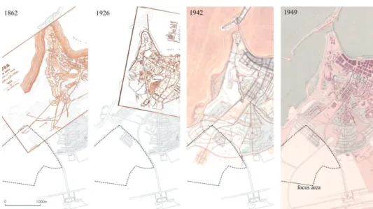
It is not easy to define when the area of Prenda was first occupied. It was probably a rural area in the 19th century, given that in the city plan of 1862, by F.
Dutra, one can see the Maianga11 do Rei and the Casa da Guarda in the area.
Ramiro Ladeiro Monteiro (1973, p. 78) situates Prenda’s emergence together with Rangel, Calemba, Catambor, Lixeira and Caputo. The first nucleus of
cuba-tas12 settled around an arimo13 belonging to an European named Prenda; similar
adoptions of names occurred in most musseques. As the plan of 1926 does not include this area, whether it was already a musseque or still rural, it was not yet considered as pertaining to the city.
Given Prenda’s location (expansion area in the periphery, with healthy sea breezes and good views), it was soon included in the urban plans developed for Luanda14. The first urban plan, in 1942, by Etienne de Gröer and David Moreira
da Silva, presents the area with a series of curvilinear streets, which were never built, and, in 1948, Castro Lopo refers to Prenda as a musseque. The later plan of 1949, by the Colonial Urbanization Office, reveals two groups of three parallel streets planned for the area near Av. João III. The easternmost streets were built, integrated in later plans, and remain until present times.
In 1964, the Musseque Prenda had an estimated population of 13.000 inhabi-tants. In a comparative study of musseques, which also included Coreia do Norte, Samba Pequena, Catambor, Bananeira Sambizanga, Mota and Lixeira, Prenda was the second most populous and the one with the largest non-African
popula-10 The decision not to translate “Bairro” to “neighborhood” relates to its specific concept in Luanda. It can mean a large area of the city as well as a more specific community. Nowadays, the Municipality of Luanda is divided into six Urban Districts, which are then divided into Bairros. Prenda belongs to Maianga’s Urban District, but is also, non-officially, divided into smaller areas (Baixo Prenda, Margos, Chabá…)
11 Maianga comes from kimbundo mazanga, meaning a site once submerged by rainwater. 12 House units of a Musseque; huts.
13 Name given to farmland close to houses or settlements in Angola.
14 From 1942 until independence in 1975, several urbanization plans were elaborated for the city in order to control its rapid growth, although only the one of 1973 was approved, but never implemented. A few aspects of every plan developed, though, were materialized through partial plans.
tion. There were no official commercial establishments in the area, although there were 99 informal (not legalized) establishments, 84 mixed trade shops (comércio
misto), 3 bars (botequins) and 12 groceries (quitandas) (Amaral, 1968, pp. 70-71, p.
119).
Figure 1: Representation of the focus area on different plans
Source: Amaral (1968) – Plan 1862 & Plan 1926; Cruz (2012) – Plan 1942; Silveira (1956) – Plan 1949
Neighbourhood Unit number 1
In 1961, Simões de Carvalho took the lead in Luanda’s urban development as chief-architect of the newly created Municipal Urbanization Office. A multi-disciplinary team of architects, engineers, architectural drafters, a surveyor and a painter was put in charge of the new Master Plan of Luanda. It was the first time a city plan would be drawn on a scientific basis. Surveys were made on housing, industry, trade and business, automobile traffic and population den-sity. Investigations were carried out in musseque Prenda and other transgressio-nal settlements (bairros em transgressão). Furthermore, the whole plan was drawn in accordance with what Simões de Carvalho had learnt from Auzelle and Le Corbusier during his stay in Paris, in addition to his own experience of being born and raised in Luanda.
In his 1963 article “Luanda do Futuro”, he exposes the concept and the main actions of the Plan. First and foremost, he wants to heal Luanda of its diseases, which he identifies with the radial city model. Within the logic of linear city, he divides the total urban area into Neighbourhood Units, combining dwelling,
working and leisure in the same area, allowing the city to grow naturally, albeit in a controlled manner. Each Unit should have its own facilities, such as schools, groceries, gardens, cinemas and churches within a walking distance. Three or four Units combined form one Bairro. The 7V’s hierarchy system of Le Corbusier is applied to the city’s road system. Two main axes, crossed by four rings, connect the city with the hinterland. Together with the boundaries of the Neighbourhood Units, they form the fast traffic system. Inside the Units, on the contrary, the em-phasis lies on walkability (Simões de Carvalho, 1963).
The Master Plan was never approved or even finished, as the beginning of the Colonial War (1961) required more pragmatic measures. The ideas behind the plan were applied through Partial Plans for Neighbourhood Units as it occurred in the case of Prenda Neighbourhood Unit number 115. Simões de Carvalho and
Luiz Taquelim designed its plan between 1961 and 1963.
Figures 2 and 3: Neighbourhood Unit number 1: project model and construction
Source: Fig. 2 – Fonte 2012; Fig. 3 – Cargo Collective16
The Unit had 25 to 30 hectares and was designed for 5.000 to 10.000 inhabitants. It consisted of a combination of four different typologies of housing, depending on the economic capacity. There were detached houses for the richer, townhou-ses (casas em banda) for the less rich, apartment buildings for the middle class and “houses with a courtyard”, to be self-constructed by the indigenous, who were connected with the traditional origins of the musseque (Milheiro, 2010, p. 313). The idea behind the design was to promote miscegenation, given that the pro-posal was for it to be inhabited by 2/3 of indigenous population and 1/3 European. Although the authorities did not allow this proportion, they still succeeded in
15 Neighborhood Unit number 3 was also planned; it was constructed, yet the architectural project was not elaborated by Simões de Carvalho and the plan changed considerably.
16 http://cargocollective.com/arquitecturamodernaluanda/filter/Obras/Bloques-residenciales-de-PrecolFernao-Si moes-de-Carvalho-y-Jose-Pinto
allotting 1/3 indigenous population and 2/3 of Europeans. The idea, however, was not for the indigenous to move directly to the Neighbourhood Unit, but to first adapt to an urbanized lifestyle by passing through a “schooling-neighbourhood” (bairro-escola).
The location of the buildings is in accordance with the Charter of Athens, with distances that allow a controlled population density. The commercial street, type V4, with large sidewalks, crosses and organizes the whole unit. Along this street, were the highest buildings, type A, combining apartments and offices over a continuous commercial one-storey front. On both ends, there were sequences of lower buildings, type B and D. A cinema, a church, a shopping gallery, schools and a health care centre were also projected in association with the commercial street, but they were never built.
As the architectural project was awarded to the construction company PRECOL, Simões de Carvalho was also asked to design the buildings, which he did together with Fernando Alfredo Pereira and José Augusto Pinto da Cunha. That way, Prenda became one of few examples where plan and project coincide in the same person, making the project a kind of a detail of the plan.
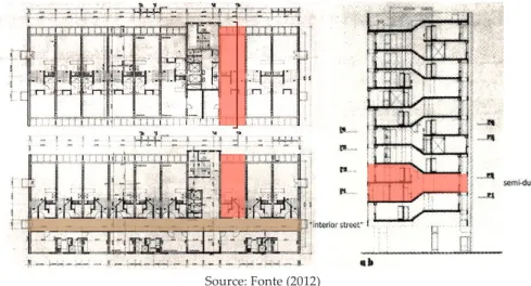
Figure 4: First and second floor plans and cross-section of Apartment Buildings type A
Source: Fonte (2012)
The apartment buildings, the only ones that were built, were designed with modernist concepts and elements adapted to the tropical climate. Different typo-logies were combined in each building, from T1 to T4, for a single person or for a big family. Most of them were semi-duplexes17, accessible by an “interior street”,
which allowed the air to circulate through the apartment, taking advantage of
Luanda’s breeze for ventilation. All were designed with the help of Modulor and the inner organization has similarities to Le Corbusier’s Unités d’Habitation.
The façade design protects the interior from sun exposure with protruded stories and screens (grelhagens). The pilotis in the ground floor also allowed air to circulate and created shaded public space. Twenty of the twenty-eight projected buildings were fully constructed and three were not concluded.
Simões de Carvalho also projected his own house in the neighbourhood, a clearly modernist project, which was built in 1966.
Figures 5 and 6: Simões de Carvalho’s house in Prenda: in the 60’s and nowadays.
Source: Fig. 5 – Cargo Colletive18; Fig. 6 – Author (May 2013)
Informality takes over and continues the formal project
Due to the beginning of the Civil War (1975), the construction of the projected neighbourhood was never completed. The housing problem in Luanda increa-sed, and Prenda had the right location and enough free space. The area of the
musseque continued to grow and penetrated the open spaces of the formal plan,
in the same way as in the unfinished buildings.
Most of the detached houses or townhouses are well preserved and seem to main-tain the integrity of the original project. Perceptible modifications lie in the search for safety, with bars in the windows and higher walls and fences. In addition, the open space of the courtyard was once important for the extended family to gather during the day, as the scale of the house allows many family relatives to find a temporary home there. The small kitchen, however, did not meet the needs and the great importance of cooking and eating as gathering activities, so, in the visited house, the backyard was transformed into a wider kitchen.
18 http://cargocollective.com/arquitecturamodernaluanda/filter/Obras/Casa-del-arquitecto-en-el-barrio-de-Prend
Fig. 7: Relation between Luanda’s population (estimates) and Prenda’s occupation density
Source: Lukombo (2011)
Figures 8 and 9: Visited townhouse: main façade and new kitchen
Figures10 and 11: Apartment buildings
Source: Author (May 2013)
Concerning the apartment buildings, one must distinguish between fully
cons-tructed and unfinished buildings, which remained as skeletons of concrete slabs,
columns and stairs. The former are to be found in different states of conservation. For example, the lift never worked in most buildings, but it did for some time in Building 1119. All over the façade, one can see many satellite dishes, as well as
air--conditioning equipment and closed balconies, which disrupt the projected effect of natural ventilation. There is wiring coming out of windows, connecting to small cages with generators inside next to the buildings, or connecting to houses in the vicinity. In the need of space, mostly commercial premises have occupied the pilotis of the ground floors, with the exception of Building 1, where it remains free, yet without the desired quality for a public space. Whereas the T1 typology does not suit the common large Angolan family needs, the semi-duplex T4, by contrast, offers adequate and proportionate accommodation – and is located near the centre, nowadays a most unusual housing offer in Luanda.
As to the unfinished apartment buildings, newcomers progressively occupied them. In 1998, when the representative of the residents of one of the buildin-gs arrived in Luanda, only the lower floors were occupied. Now, almost all of the building looks inhabited. A great variety of materials and openings make up the design of the façade, since residents built in walls, windows and all other elements. Many wires and pipes connect the different floors with the electricity source or the ground. Even though the unfinished buildings represented an op-portunity to obtain a dwelling near the centre in a time of need, at present they do not offer desirable living conditions, considering they lack all infrastructures and are unsafe for young children, for instance.
Figures 12 and 13: Unfinished Apartment Buildings and, in contrast, Building 22
Source: Author (May 2013)
Figures 14 and 15: Visited self-constructed house, main façade and living room
Source: Author (May 2013)
The self-constructed houses form a heterogeneous urban tissue, with a great variety of materials, population and house qualities. The courtyard lost its signi-ficance as the need for housing and densification took place. Side by side, one can find a reconstructed two-storey house with permanent and quality materials and a precarious construction with zinc walls and almost no divisions. The first one invested in infrastructures, like water tanks, generators and pit latrines, the same way dwellers of detached houses or apartment buildings had to do on account of the lack of quality of public supply.
In the second case, people strive to live without any infrastructures, except for “stolen” water and electricity (the so-called puxadas). Although the tempo-rality of the construction is similar to that of the old musseque, living conditions cannot be compared, given, for instance, there is no courtyard to assure privacy in open space and so fulfil family needs. If the Government gave them a house, they would not hesitate to leave – a resident in one of these houses assured me.
Figures 16, 17 and 18: Materials and construction quality of self-construction houses. Various aspects
Source: Author (May 2013)
Doubts for the future
Several press reports referring to Bairro Prenda have been published over the last years in the context of Luanda’s reconstruction.
In 2008, the project was to demolish the apartment buildings and re-urbanize the area, according to the director of IPGUL, architect Hélder José. A public-private partnership was in charge of the project, and the residents were to be relocated onto the Camama/Viana road, about 15km from the centre, or find other solu-tions if they wanted to move somewhere else. This action should have started in 2009, but was never accomplished.
In 2009 the news changed, as the second phase of an urban requalification plan for Prenda was to be the rehabilitation of the apartment buildings. The struc-ture was to be preserved, the façades improved, as well as the quality of the architecture. The degraded ground floor was not to be forgotten. However, since the value of the houses was expected to increase, the residents without economic means to remain in the buildings should leave, as should those occupying the former public spaces between buildings, which imply the gentrification of the area. The population was to be relocated in Viana Municipality. The same press report claims that the resettlement houses were already under construction.
Still, in 2010, it was reported that the project had stopped because of problems concerning the relocations. The construction company in charge, Pidi Urbana e
Tanix, on a public-private partnership basis, was only planning the simple
trans-fer from Prenda to the resettlement area, but it was necessary to create other mechanisms in order to fulfil the residents’ wishes for options.
In 2011 and 2012, the public space was improved. Scrap and abandoned vehicles were taken away and some streets of Prenda were paved, namely those that pro-vide access to the detached and townhouses and the apartment buildings. The main streets of the self-constructed areas remained unpaved, although they are wide enough for cars to pass through.
Conclusions (and questions)
The case of Prenda allows us to see that, in order to fulfil new needs, informal processes have been shaping not only self-constructed areas, but also previously formal ones. Over time, the distinction between formal and informal has beco-me increasingly diffuse. The distinction that can and should be done is between acceptable and insecure living conditions. That is to say, there are people with access to improved water, improved sanitation, with sufficient living area in a durable house, although maybe without security of tenure, in all typologies – as well as many people lacking these conditions, who would like to live in a better house.
Although often associated, informality is not the same as poverty, rather a response to it and the result of a big effort made by Luanda’s inhabitants. In or-der to reduce poverty and poor living conditions, the approach should be more sensitive. Sometimes it can be a better policy to improve informal settlements ins-tead of destroying them, which can look like a step back rather than forward. But common resettlements in Luanda push the population towards the periphery, perpetuating the segregation that always existed. Shouldn’t we learn a lesson from the Neighbourhood Units?
Yet, segregation in Luanda is increasing: gated communities for those who choose to segregate themselves in order to find safety and poor neighbourhoo-ds without infrastructures for those without a choice. Although the project for Prenda never reached completion as originally designed, the result today is an almost self-sufficient bairro with a great range of services, where different hou-sing typologies coexist and there is a sense of neighbourliness. Shouldn’t a city provide for the miscegenation of cultures, religions and social and economic stra-ta, which all have the same right to the city?
The future is unpredictable, but the ghost of demolition lies ahead of each self--constructed house without land tenure. Formerly, there was some distinction between musseques and other transgressional neighbourhoods. The musseques were destroyed by the formal city, but others overruled the formal plans and forced them to adapt. Did the difference lie solely in the construction materials
and population? The old musseques, with their non-permanent materials and big backyards, evolved into dense neighbourhoods of cement blocks which house 80% of Luanda’s inhabitants. Their construction is mostly permanent and they provided some of the needed infrastructures. Shouldn’t they be included in for-mal plans and considered for improvements?
References
Amaral, I. (1968). Luanda (Estudo de geografia urbana). Junta de Investigaçãoes do Ultramar: Lisboa.
Cruz, D. (2012). Memórias de um Mercado Tropical. O Mercado do Kinaxixe e Vasco Vieira da Costa. Integrated master dissertation. Coimbra: Faculdade de Ciências e Tecnologia da Universidade de Coimbra.
Fernández, R. (1996). Modos de hacer ciudad: Proyecto y plan. Revista Ciudades, 3, pp. 111-127. In http://dialnet.unirioja.es/descarga/articulo/2241380.pdf (Accessed on 13 December 2012).
Fonte, M. M. (2012). Urbanismo e Arquitectura em Angola: de Norton de Matos à Revolução. Doctoral dissertation. Lisboa: Universidade Técnica de Lisboa. Faculdade de Arquitectura. In http://hdl.handle.net/10400.5/2027
Jenkins, P., & Andersen, J. E. (2011). Developing Cities in between the Formal and Informal. 4th European Conference on African Studies (ECAS 2011). Uppsala, Sweden: The Nordic Africa Institute. In http://www.nai.uu.se/ecas-4/panels/81-100/panel-85/Jenkins-and-Eskemose-Full-paper.pdf (Accessed on 22 December 2012).
Lukombo, J. B. (2011). Crescimento da população em Angola: “Um olhar sobre a situação e dinâmica populacional da cidade de Luanda”. Revista de Estudos Demográficos, 49, pp. 53-67.
Milheiro, A. V. (2010). Luanda no futuro: o Bairro Prenda. Exhibition A Cidade popular: África/Brasil / The popular city: Africa/Brazil (pp. 308-317). In https://docs.google.com/file/ d/0B3MllcndJsdCME5Sbm52QUFLMkk/edit?pli=1(Accessed 29 May 2013).
Monteiro, R. L. (1973). A Família nos Musseques de Luanda: Subsídios para o seu estudo. Licentiate dissertation. Luanda: Fundo de Acção Social no Trabalho em Angola. Ondjaki (2012). Os transparentes. Lisboa: Editorial Caminho.
Silveira, L. (1956). Ensaio de Iconografia das Cidades Portuguesas do Ultramar. Lisboa: Junta de Investigações do Ultramar. In http://memoria-africa.ua.pt/Library/ShowImage.aspx?q=/ EICPU/EICPU-2&p=95
Sousa, M. A. (1995). Contribuição para o Conhecimento do Sector Informal – Luanda. Unpublished.
United Nations Human Settlements Programme. (2003). The challenge of slums: global report on human settlements 2003. In http://mirror.unhabitat.org/pmss/listItemDetails. aspx?publicationID=1156 (Accessed on 12 August 2013).
Venâncio, J. C. (1984). Espaço e Dinâmica Populacional em Luanda no Século XVIII. Revista de História Económica e Social, 14, pp. 67-89.
Vieira, J. L. (1963). Vavó Xixi e seu neto Zeca Santos. In Luuanda – estórias. Lisboa: Edições 70.