Maria Rita DonalisioI Ricardo CordeiroI
Roberto Wagner LourençoII
J Christopher BrownIII
I Departamento de Saúde Coletiva. Faculdade
de Ciências Médica. Universidade Estadual de Campinas. Campinas, SP, Brasil
II Programa de Pós-Graduação em Ciências
Ambientais. Engenharia Ambiental. Universidade Estadual de São Paulo. Sorocaba, SP, Brasil
III Department of Geography. University of
Kansas. Lawrence, Kansas, USA Correspondence:
Maria Rita Donalisio
Rua Tessália Vieira de Camargo, 126 13083-970 Campinas, SP, Brasil E-mail: [email protected] Received: 12/10/2012 Approved: 5/7/2013
Article available from: www.scielo.br/rsp
The AIDS epidemic in the Amazon
region: a spatial case-control
study in Rondonia, Brazil
Epidemia da Aids na região amazônica:
estudo caso controle espacial em
Rondônia, Brasil
ABSTRACT
OBJECTIVE: To analyze spatial changes in the risk of AIDS and the relationship between AIDS incidence and socioeconomic variables in the state of Rondonia, Amazon region.
METHODS: A spatial, population case-control study in Rondonia, Brazil, based on 1,780 cases reported to the Epidemiological Surveillance System and controls
based on demographic data from 1987 to 2006. The cases were grouped into ive
consecutive four-year periods. A generalized additive model was adjusted to the data; the dependent variable was the status of the individuals (case or control), and the independent variables were a bi-dimensional spline of the geographic coordinates and some municipality-level socioeconomic variables. The observed values of the Moran’s I test were compared to a reference distribution of values generated under conditions of spatial randomness.
RESULTS: AIDS risk shows a marked spatial and temporal pattern. The disease incidence is related to socioeconomic variables at the municipal level in Rondônia, such as urbanization and human capital. The highest incidence rates of AIDS are in municipalities along the BR-364 highway and calculations of the Moran’s I test show positive spatial correlation associated with proximity of the municipality to the highway in the third and fourth periods (p = 0.05).
CONCLUSIONS: Incidence of the disease is higher in municipalities of greater economic wealth and urbanization, and in those municipalities bisected by Rondônia’s main roads. The rapid development associated with the opening up of once remote regions may be accompanied by an increase in these risks to health.
The spread of HIV/AIDS in Brazil has presented a variety of diffusion mechanisms, potentially related to social, economic and demographic factors.1,2 HIV/
AIDS infection has been described as a “mosaic of sub-epidemics”; each one has particular dissemina-tion dynamics and characteristics, and each exposes particular vulnerabilities of the population in regions of Brazil.3,4,8 With 600,000 people living with HIV/AIDS
and 400,000 reported cases, since the beginning of the epidemics in Brazil, a number of regional differences in diffusion stand out: intravenous drug-use-related infection in the South; rising infection rates in lower socioeconomic brackets throughout the country and in municipalities along Brazil’s frontier regions in the North and Midwest in formal and placer mining areas; and deceleration of the epidemic in the urban Southeast, where prevention efforts are most prevalent.8,10,20,a
RESUMO
OBJETIVO: Analisar mudanças espaciais no risco de Aids e a relação entre incidência da doença e variáveis socioeconômicas.
MÉTODOS: Estudo caso-controle espacial, de base populacional, realizado
em Rondônia, Brasil, com 1.780 casos notiicados pelo Sistema de Vigilância Epidemiológica e os controles a partir de dados demográicos de 1987 a 2006.
Os casos foram agrupados em cinco períodos de cinco anos consecutivos. Um modelo aditivo generalizado foi ajustado aos dados. O status dos indivíduos (caso ou controle) foi considerado como a variável dependente e independente: um alisamento (spline) bidimensional das coordenadas geográicas e variáveis
socioeconômicas municipais. Os valores observados para o teste Moran I foram comparados com a distribuição de referência dos valores obtidos em condições de aleatoriedade espacial.
RESULTADOS: O risco de Aids apresentou padrão espacial e temporal marcado. A incidência associou-se a indicadores socioeconômicos municipais, como urbanização e capital humano. As maiores taxas de incidência de Aids ocorreram em municípios ao longo da rodovia BR-364; os resultados do teste Moran I mostram correlação espacial positiva associada à contiguidade dos municípios com a rodovia, no terceiro e quarto períodos (p = 0,05).
CONCLUSÕES: A incidência da doença foi maior em municípios de maior riqueza econômica e urbanização e naqueles cortados pelas estradas principais de Rondônia. O rápido desenvolvimento associado à ocupação de regiões remotas pode ser acompanhado por aumento de riscos à saúde.
DESCRITORES: Síndrome de Imunodeiciência Adquirida,
epidemiologia. Fatores Socioeconômicos. Análise Espacial. Urbanização. Estudos de Casos e Controles.
INTRODUCTION
According to the 2010 World Report on the AIDS epidemic,11 the incidence of disease is diminishing
in southeastern Brazil, and it is stable in the rest of the country, except in the North, where it continues to increase: The incidence rate of AIDS (per 100,000 inhabitants) went from 13.6 in 2006 to 20.1 in 2009.b
Studies have recorded the geographic spread of the epidemic in the Midwestern and Northern states, but little is known about the path of transmission in these regions, which are far from areas where transmission has a longer history. Infection has expanded in the Midwestern and Northern areas, mainly affecting heterosexuals, individuals with lower levels of educa-tion and few intravenous drug users.18,a
HIV/AIDS arrived in the state of Rondonia, Northern
Brazil, seven years after the irst cases were registered
a Barcellos C, Peiter P, Rojas LI. Matida A. A geografia da AIDS nas fronteiras do Brasil. Campinas; 2001 [cited 2013 Sept 11]. Available from:
http://www.igeo.ufrj.br/fronteiras/pesquisa/fronteira/p02pub03.htm#1.2
b Ministério da Saúde, Secretaria de Vigilância em Saúde, Departamento de DST, AIDS e Hepatites Virais. Bol Epidemiol AIDS-DST.
in the Southeast, and the initial pattern of infection in
Rondonia differed from that found in the irst decade of
the epidemic. AIDS has affected mainly urban, well-ed-ucated homosexual/bisexual males in Southeastern Brazil.3,18,20 The then-territory of Rondonia was relatively
isolated from the rest of the country until the 1960s. It was covered mostly by tropical forest and inhabited mainly by rubber tappers and indigenous people. That is
when the irst overland connection to the state was made
via construction of the federal highway BR-364 (Figure). The road was only dirt, made along the very trail, and
eventual telegraph line, that Coronel Cândido Rondon irst blazed in the early 1900s. The state’s 1970 popu -lation was estimated at 70,000 and by 1991 it had risen to 1,132,692.5,c The paving of the BR-364 highway in
1983, and subsequent agricultural colonization projects led by the Brazilian government, allowed thousands of families to begin moving into the region, largely from Brazil’s South and Southeast. The territory became a state in 1982 and the state had 52 municipalities and a total population of 1.4 million in 2007.d
Much understanding of the pattern of AIDS diffusion in places like Rondonia may come from close consideration of the settlement geography of this relatively remote region. The occupation of the state was strongly patterned by the federal highway BR-364, which bisected the state from Vilhena in the southeast to the capital city, Porto Velho, in the northwest on the Madeira River.c Along that
road, the state’s most populous municipalities formed as centers of agricultural settlement. Urban centers arose along the road, and families were settled on either side, extending some 80 to 100 km into what were mostly heavily forested areas. Two other major axes of settle-ment and spatial interaction that developed in the state ran along the state highway 429 from Presidente Médici (located on the BR-364) southwest to Costa Marques along the Guaporé River, and state highway 425 from the BR-364 west of Porto Velho South to the city of Guajará-Mirim, along the Mamoré River (Figure). Both rivers help form the Rondonia border with Bolivia. Costa
Marques and Guajará-Mirim have signiicant spatial
interactions with Bolivia across the rivers, related to everyday trade and likely illicit activities such as logging
and drug traficking. These patterns of spatial interaction
along main transportation axes are important to consider in a developing area like Rondonia where many adja-cent municipalities have little interaction between them because there is no road connecting them.
This study aimed to analyze spatial changes in the risk of AIDS and the relationship between AIDS incidence and municipal-level socioeconomic variables. This study can contribute to understanding the diffusion dynamics of the epidemic in the North of the country, where transmission began late in relation to other regions of Brazil.
c Mahar DJ. Government policies and deforestation in Brazil’s Amazon Region. Washington (DC): World Bank; 1989.
d State of Rondonia Government [Internet]. Porto Velho; 2007 [cited 2013 Oct 31]. Available from: http://www.rondonia.ro.gov.br/ METHODS
The study involved all cases of AIDS in Rondonia (n = 1,780), reported by Brazil’s Epidemiological Surveillance System and provided by the Health Statistics System (DATASUS), from 1987 to 2006. The
reported cases were grouped into ive consecutive
four-year periods: 1987 to 1990, 1991 to 1994, 1995 to 1998, 1999 to 2002, and 2003 to 2006. This was done because changes in AIDS incidence are too small in Rondonia to be tracked on an annual time-scale. AIDS incidence was reported according to the municipal residence of the individual, not the municipal location of the reporting. Incidence rates of AIDS per 100,000 inhabitants for each four-year period were calculated for the municipal-ities of the state. For the denominator, the mean popu-lation for each four-year period was used, and it was calculated from demographic census data (1991, 1996, 2000, and 2007) obtained from the Brazilian Institute of Geography and Statistics (IBGE). The municipal population between census years was estimated by interpolating known values, with a geometric function. The geographic distribution of risk of AIDS in the state was estimated by performing a spatial case-con-trol study based on secondary population data for each period. The reports of AIDS among residents of Rondonia comprised the individuals in the case group.
The controls were selected through a stratiied random
sample of municipalities in Rondonia. In each stratum, individuals were sampled in proportion to the estimated
population of the city in the middle of the four-year period analyzed. The geographic coordinates (latitude and longitude) of the cases and controls were set at the centroids of each municipality. These data were obtained from IBGE, using the Universal Transverse Mercator Projection and Datum SAD69.
A generalized additive model (GAM) was adjusted to the data. The dependent variable was the status of the individ-uals (case or control), and the independent variable was a bi-dimensional spline of the geographic coordinates. The municipal-level socioeconomic variables were obtained from the Institute for Applied Economic Research (IPEA): percent of population living in the urban zone, number of doctors per thousand inhabi-tants, human capital (the difference between expected income obtained by the work force of the municipality in the labor market and the estimate of that obtained by workers without education and experience), gross national product (a form of municipal-level gross domestic product), and a human development index (a composite of education, income, and life expectancy). These variables are used frequently in economic and demographic studies.e
A logistic regression model was adjusted with the dependent variable being the status of the individual (case = 1, control = 0) for each four-year period studied, with municipal-level socioeconomic indicators as independent variables analyzed in the middle of the four-year period.
The signiicance level of the estimates obtained for the spatial distribution of AIDS risk was veriied using a
Monte Carlo algorithm proposed by Kelsall & Diggle12
(1998). The adjustment was performed using the soft-ware R, version 2.11.1, library mgcv. The Moran’s I statistic was calculated to estimate spatial autocorrelation of AIDS incidence for each four-year period.8,a This was
done using two different matrices that deined the spatial contiguity among the municipalities. The irst deined
two municipalities as neighbors when their borders shared any point of contact with each other (queen
weights). The second deined municipalities as neigh -bors only if the above condition was complemented by the municipalities being connected by a federal or state highway (road weights), based on the 1993 edition of the Rondonia State Road Map produced by the Department of Highways and Roads (DER-RO). The statistical signif-icance level of the observed Moran’s I was established by comparing it to a reference distribution of Moran’s I values generated under conditions of spatial randomness. The calculations were performed using GEODA, version OpenGeoDa beta release 0.9.9.14.
RESULTS
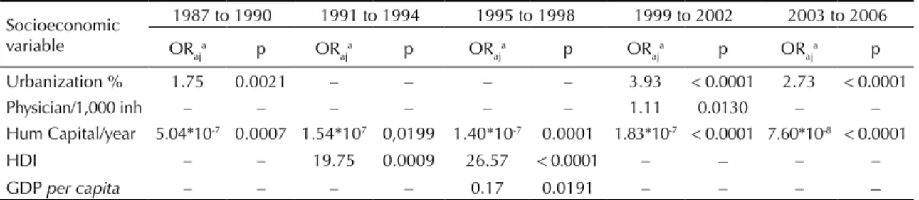
There were 1,765 cases of AIDS reported among resi-dents of Rondonia from 1987 to 2006, with a progres-sive increase throughout the four-year periods studied (Table 1). An increase in the proportion of cases among women was observed: the male/female ratio reached 1.5 after the third four-year period. There was a decrease in individuals in the homosexual/bisexual and intravenous drug use categories and an increase in the percentage and absolute number of heterosexuals affected in the second four-year period. Considering the 10 munici-palities with the highest incidence rates of the 52, 8 were bisected by the federal highway BR-364 (Table 2). Urbanization and human capital were positively asso-ciated with AIDS risk in Rondonia, and the number of doctors per thousand inhabitants was negatively associated (Table 3).
AIDS risk was irst detected in the northwest of the
state near Rondonia’s capital. A center of risk then emerges in the southeast along the border with the state of Mato Grosso, eventually affecting eastern Rondonia. Risk was present in areas along the federal highway BR-364 in the 1991 to 1994 period, distant from western Rondonia. Risk appeared on the border with Bolivia toward the end of the 1990s. AIDS risk
Table 1. Sex and categories of transmission of AIDS in five four-year periods. Rondonia, Northern Brazil, 1987 to 2006.
Four-year period Sex ratio Male/Fem
Homo/Bi. sexual Het. sexual IDU Not reporteda Total
Freq. % Freq. % Freq. % Freq. % Freq. %
1987 to 1990 7 7 29.2 6 25.0 4 16.6 7 29.2 24 1.4 1991 to 1994 2.5 18 16.1 52 46.4 19 17.0 23 20.5 112 6.4 1995 to 1998 1.5 47 16.7 172 61.0 24 8.5 39 13.8 282 15.9 1999 to 2002 1.3 70 13.2 332 62.8 29 5.5 98 18.5 529 30.0
2003 to 2006 1.3 56 6.9 536 64.2 16 4.1 210 25.6 818 46.3 Total 2.0 198 11.2 1,098 62.2 92 5.2 377 21.4 1,765 100.0 IDU: Intravenous drug user
a Not reported and others, such as blood transfusion and occupational
spreads throughout the state into areas that were
previously safe from the epidemic in the inal
four-year period. The risk of AIDS was particularly high (OR = 5) at the border with the state of Acre along the BR-425 highway and at the border with the state of Mato Grosso (Annex 1).
The Annex 2 shows the semi-parametric spatial distri-bution of AIDS risk, i.e., controlling for the non-spatial covariates selected in the multinomial adjustment and
signiicant areas (in gray), for each four-year period. The irst period (1987 to 1990) was not presented because the entire distribution was not signiicant (all
gray). The spatial models adjusted by socioeconomic variables show that the borders with Bolivia, the state of Mato Grosso and Acre were important areas of risk. Socioeconomic variables like urbanization and human capital explained the risk in the region of the capital city, Porto Velho, and along the highway BR-425 to the state of Acre, but there was still an excess of risk in Porto Velho (north) and the Vilhena region in the south. White areas corresponded to low-risk unpopulated and isolated regions.
The values obtained for the third and fourth four-year
period, using the road-based contiguity, were signiicant (p = 0.05), with the others not signiicant (Table 4).
DISCUSSION
The data show a steady growth of AIDS risk throughout the years of the study, starting along the main roads and in the most developed regions and spreading through all municipalities of Rondonia. The spatial and temporal distribution of AIDS risk in the state is associated with socioeconomic and contextual determinants. The diffusion pattern in the state differs from regions in Brazil where HIV transmission has a longer history. The beginning of AIDS transmission in Rondonia came
late, with the irst reported case in 1987, a few years
after the main highway through the state, the BR-364,
was irst paved. In the mid-1990s, the highest incidence
was already among heterosexuals, in individuals with lower levels of education, and a small proportion of cases were found among intravenous drug-users. The sex ratio of affected people (males/females) was nearly equal at the time, suggesting a heterosexual transmis-sion pattern. The dissemination of AIDS and the factors that maintain the epidemic in the region were different
than in other regions of the country in the irst decade of the epidemic. These same characteristics were identiied
in the Midwest, North and other frontier areas of Brazil, most intensely after the 1990s.17-19,a
The epidemic irst began in the northwest of Rondonia,
the site of the state’s capital, Porto Velho, which is the political and economic hub of the region. The multiple logistic regression showed greater disease risk being maintained in municipalities with higher urbanization
and income over the ive periods. Higher levels of
human capital were also associated with the disease. Municipalities with higher urbanization and population density, accompanied by economic relationships with other regions, tend to attract migratory populations and seasonal workers.2,9 Regions with greater
move-ment of people, goods, and associated changes in the sociodemographic structure have been shown to have increased infection risk, in Brazil and worldwide.2,9,17
The disease is associated with a reduced number of doctors (doctors per 1,000 inhabitants) in the fourth period. This indicates the importance of health services and related educational and prevention programs in preventing AIDS. More study would be needed to determine whether the number of doctors per 1,000 inhabitants is indeed a good indicator of overall health services. HIV/AIDS control programs have positive impact on controlling AIDS morbidity and mortality in the Southeast region of Brazil.16
Table 2. Cases and incidence rates (per 100,000 inhabitants) in Rondônia’s municipalities (ten-highest of 52 municipalities). Rondonia, Northern Brazil, 1987 to 2006.
Municipality 1987 to 1990 Cases/Incid.b
1991 to 1994 Cases/Incid.a
1995 to 1998 Cases/Incid.b
1999 to 2002 Cases/Incid.b
2003 to 2006 Cases/Incid.b
Porto Velho 21/7.3 81/28.2 180/61.6 364/108.8 448/124.4 Vilhenaa 4/10.2 3/7.6 31/69.8 31/57.8 75/124.4
Ji-Paranáa 0/0 10/10.2 12/12.7 30/28.1 56/52.1
Cacoala 0/0 3/3.8 14/19.2 14/19.0 42/55.2
Ariquemesa 0/0 4/4.8 5/7.3 17/22.8 41/49.7
Jarua 0/0 2/3.2 7/14.6 4/7.5 14/26.7
Guajará-Mirim 1/3.1 2/6.1 4/11.1 5/13.1 11/27.9 Presid. Medicia 0/0 7/23.3 3/10.9 6/22.7 6/27.0
Pimenta Buenoa 0/0 0/0 4/8.4 8/25.2 10/30.4
Candéias Jamaria 0/0 0/0 0/0 6/45.8 13/77.7 a Municipalities bisected by federal highway BR-364
With the general relationship established between disease incidence and urbanization, one can also explore mechanisms of spatial interaction that allow diffusion of the disease among urban centers. A visual comparison of Figure and Annex 1 suggests a spatial-temporal resemblance between the path of the main highways in the state and the spread of AIDS risk in the second, third, and fourth periods. The Moran’s I statistics for disease incidence provide a more rigorous test of the importance of Rondonia’s road network in the spread of the disease. The Moran’s I that considered
the road network (road weights) was signiicant, which
is consistent with the hypothesis that the road network played a major role in the diffusion of the disease. A
signiicant Moran’s I is an indication of spatial auto
-correlation in the data. Moran’s I was signiicant for the
third and fourth periods, but only when municipalities were designated as neighbors in the spatial contiguity matrix by sharing a border and a connection via state or federal highways. The highest incidence rates of AIDS in municipalities along the BR-364 highway and the Moran’s I analysis are consistent with the explanation that AIDS followed the road network in Rondonia along with the development and occupation of urban spaces.
The data cannot be used to conirm exactly what mecha -nisms of spatial interaction initially allowed AIDS to arrive in the state and to then diffuse within it, but the spatial-temporal results do suggest some plausible
scenarios. Disease risk irst appears in the extreme
northern and then int the extreme southern parts of the
state. The northern region is under the inluence of Porto
Velho, the state capital, which has a major airport. It could be that middle-to upper-class air travelers from other regions of the country initially brought it to Porto
Velho, spreading the disease irst among homosexual/
bisexual males in the urban area of the capital. The next emerging area of risk then appears in the extreme south of Rondonia, in the region of Vilhena, suggesting some
potential inluence from neighboring Mato Grosso state
via ground transportation, since Vilhena has no major airport. Disease risk spreads to other parts of the state, likely via ground transportation (buses and commercial trucking) along state and federal highways in the subse-quent periods of the study. The spread of the disease during these periods could be due to transmission of HIV within the heterosexual and less educated popula-tion, as suggested by socioeconomic and epidemiologic data. An especially vulnerable group is comprised of people who have occupations involving trucking and prostitution, as pointed out by studies in developed and developing countries.13,15,22
The relationship between highways, frontier expansion and health threats (particularly violence, malaria and AIDS) in the central Brazilian Amazon was suggested by Barcellos et al2 (2010). Such development increased
economic expansion. However, it attracted migrants searching for work and a better life, eventually leading to growth in a marginalized population concentrated along the region’s main highway, allowing for daily interaction with people from various parts of the country.2 Frontier regions are often areas at high
risk of disease and death. This is due to the low of
workers, typically with lower skill and education levels, who comprise a large group of individuals vulnerable to infection via un-safe sex practices and prostitution.14,15,19,22,a An increased HIV vulnerability
may be due to a poor sense of community and inade-quate social support systems in areas dominated by migrant populations and seasonal workers.2,14,18
The results of the present study are consistent with the general picture that the rapid development associ-ated with the opening of once remote regions may be accompanied by an increase in these health threats. Annex 1 and 2 show highest risk of AIDS on the
Table 4. Moran’s I statistics and P values for five four-year periods, according to queen weights-based contiguity1 and
road weights-based contiguity.1 Rondonia, Northern Brazil,
1987 to 2006.
Four-year period Queen weights Road weights Moran’s I p Moran’s I p 1987 to 1990 -0.01 0.68 -0.09 0.17 1991 to 1994 -0.08 0.08 -0.05 0.33 1995 to 1998 -0.09 0.21 0.18 0.02 1999 to 2002 -0.06 0.31 0.16 0.06 2003 to 2006 0.05 0.17 0.04 0.32
Table 3. Results of a logistic regression model of AIDS risk in five four-year periods. Rondonia, Northern Brazil, 1987 to 2006.
Socioeconomic variable
1987 to 1990 1991 to 1994 1995 to 1998 1999 to 2002 2003 to 2006
ORaja p OR aj
a p OR
aj
a p OR
aj
a p OR
aj
a p
Urbanization % 1.75 0.0021 – – – – 3.93 < 0.0001 2.73 < 0.0001 Physician/1,000 inh – – – – – – 1.11 0.0130 – – Hum Capital/year 5.04*10-7 0.0007 1.54*107 0,0199 1.40*10-7 0.0001 1.83*10-7 < 0.0001 7.60*10-8 < 0.0001
HDI – – 19.75 0.0009 26.57 < 0.0001 – – – –
GDP per capita – – – – 0.17 0.0191 – – – –
HDI: Human Develop Index; GDP per capita: Gross domestic product per capita a OR
borders of the state, and the Moran’s I test indicates highways as associated with the disease incidence. Many regions of Rondonia have suffered from malaria
and violence since the state was irst opened to settle -ment in the 1960.2,c The highway BR-364 was paved in
1983, followed by intensiied economic development,
rapid urbanization, in-migration, and movement of
people and goods across and within the state. The irst
reports of AIDS in the state quickly followed these events. Given that Rondonia was but one center of development in the Amazon, albeit a major one, these disease patterns likely manifested themselves in similar areas in Brazil’s North. The North region’s population grew 4.0% during the 1990s, double the growth of the nation’s population as a whole during the same peri-od.5,a Vulnerability to HIV/AIDS infection in Rondonia
and elsewhere is possibly associated with the process of human occupation and regional development, through which isolated regions became more tightly integrated into the country’s economy. Socio-anthropological studies could show precise interactions and behaviors in the population living in the region, particularly along major roads, to better understand the disease risk in individual particular situations.
Studies show high risk sexual behavior among truck drivers with a poor perception of HIV infection risk, indicating the importance of movement of people and goods in putting people at risk of AIDS in Brazil.6,7,23 The existence of municipal, state, and
federal programs for AIDS control and prevention aimed at truckers at checkpoints, weigh stations, and service centers located at border crossings between
states appears justiied.3 Studies from other
devel-oping regions of the world are also consistent with the possible scenarios of disease diffusion presented here. In studies in India, Tanzania, Uganda and other countries in Africa, long-haul truckers are considered crucial agents in the dissemination of AIDS. Their impact is strengthened by the presence of impover-ished populations settled along trucking routes, where prostitution is often the only way for women to survive
from an early age.21,22,24 The role of road networks in
the dissemination of AIDS in South Africa, Uganda,
and Brazil is suggested by authors who have identiied
a strong relationship between infection and proximity to roads and commercial centers.2,6,21,22
In studies like this, bias can occur when the geographic
distribution of cases merely relects the distribution of
locations where the disease can be reported. This is not an issue in the instance of this study. AIDS in Brazil is reported by the country’s Surveillance System, which records, among other variables, the place of residence of the individual, and that variable was used in this study.
Under-notiication is also a common issue in studies,
especially when individuals contract diseases in remote areas, dying or recuperating without subsequent report of
the disease. No doubt there is under-notiication, but in
the case of AIDS, it is less of a concern than with studies of other diseases. AIDS is a severe and progressive disease in which people tend to eventually seek hospi-talization and treatment in some urban center, leading
to an oficial report of the disease, even in remote areas. Another limitation is that notiication of cases in
chronic diseases of long duration and long latency periods refers to infection that occurred in the past,
making it dificult to understand the dynamics of viral
transmission in the present.
There is a marked spatial and temporal pattern to the distribution of AIDS risk that is concentrated in Rondonia, during its expansion, in municipalities along major roads in the north and south. The epidemic is also related to socioeconomic variables at the municipal level in Rondonia, such as urbanization and human capital in municipalities that are also bisected by Rondonia’s main roads. The increase of preventive measures by the Ministry of Health directed at long-haul truckers crossing the region could have an impact on the dissemination
of the disease. Spatial analysis may aid in identiication
of disease transmission patterns in different regions,
suggesting speciic populations and locations where
This study was presented at the XIX International Aids Conference, Washington, DC, in 2012.
This study was supported by the Ministry of Education, Coordenação de Aperfeiçoamento de Pessoal de Nível Superior (CAPES – Process nº 4230/09-4 postdoctoral scholarship).
The authors declare that there are no conflicts of interest. 1. Anselin L, Bera AK,Florax R, Yoon MJ.Simple
diagnostic tests for spatial dependence.
Reg Sci Urban Econ. 1996;26(1):77-104.
DOI:10.1016/0166-0462(95)02111-6
2. Barcellos C, Feitosa P, Damacena GN, Andreazzi MA. Highways and outposts: economic development and health threats in the central Brazilian
Amazon region. Int J Health Geogr. 2010;9:30. DOI:10.1186/1476-072X-9-30
3. Benzaken AS, Galbán Garcia E, Sardinha JCG, Pedrosa VL, Paiva V. Community-based intervention to control STD/AIDS in the Amazon region, Brazil.
Rev Saude Publica. 2007;41(Suppl 2):118-126.
DOI:10.1590/S0034-89102007000900018
4. Brito AM, Castilho EA, Szwarcwald CL. AIDS e infecção pelo HIV no Brasil: uma epidemia multifacetada.
Rev Soc Bras Med Trop. 2001;34(2):207-17.
DOI:10.1590/S0037-86822001000200010
5. Brown JC, Desposato SW, Brown DS. Paving the way to political change: decentralization of development in the Brazilian Amazon. Polit Geogr.2005;24(1):39-52. DOI:10.1016/j.polgeo.2004.06.001
6. Brown JC. Responding to deforestation: productive conservation, the World Bank and beekeeping in Rondonia, Brazil. Prof Geogr. 2001;53(1):106-18. DOI:10.1111/0033-0124.00273
7. Ferguson AG, Morris CN. Mapping transactional sex on the Northern Corridor highway in Kenya. Health Place. 2007;13(2):504-19. DOI:10.1016/j.healthplace.2006.05.009
8. Fonseca MGP, Bastos FI. Twenty-five years of the AIDS epidemic in Brazil: principal epidemiological findings, 1980-2005. Cad Saude Publica. 2007;23(Suppl 3):S333-44. DOI:10.1590/S0102-311X2007001500002
9. Guest P. Population mobility in Asia and the implications for HIV/AIDS Action Programme: In: Guerny J, Hsu LN. Population movement, development and HIV/AIDS: looking towards future. Bangkok: UNDAP South East Asia HIV and Development Project; 2000. v.1, p.76-86.
10. Hacker MA, Leite IC, Renton A, Torres TG, Gracie R, Bastos FI. Reconstructing the AIDS epidemic among injection drug users in Brazil. Cad Saude Publica. 2006;22(4):751-60. DOI:10.1590/S0102-311X2006000400014
11. Joint United Nations Programme on HIV/AIDS. Global report: UNAIDS report on the global AIDS epidemic 2010. Geneva; 2010.
12. Kelsall JE, Diggle PJ. Spatial variation in risk of disease: a nonparametric binary regression approach. J R Stat Soc
Ser C Appl Stat. 1998;47(4):559-73.
DOI:10.1111/1467-9876.00128
13. Lichtenstein B, Hook EW, Grimley DM, St Lawrence JS, Bachmann LH. HIV risk among long-haul truckers
in the USA. Cult Health Sex. 2008;10(1):43-56. DOI:10.1080/136910507015829
14. Lippman SA, Kerrigan D, Chinaglia M, Dıaz R. Chaos, co-existence, and the potential for collective action: HIV-related vulnerability in Brazil’s international borders. Soc Sci Med. 2007;64(12):2464-75. DOI:10.1016/j.socscimed.2007.02.048
15. Malta M, Bastos FI, Pereira-Koller EM, Cunha MD, Marques C, Strathdee SA. Qualitative assessment of long distance truck drivers’ vulnerability to HIV/AIDS in Itajai, southern Brazil. AIDS Care. 2006;18(5):489-96. DOI:10.1080/09540120500235241
16. Melchior R, Nemes MIB, Basso CR, Castanheira ELR, Britto e Alves MTS, Buchalla CM, et al. Evaluation of the organizational structure of HIV/AIDS outpatient care in Brazil. Rev Saude Publica. 2006;40(1):143-51. DOI:10.1590/S0034-89102006000100022
17. Msisha WM, Kapiga SH, Earls FJ, Subramanian SV. Place matters: multilevel investigation of HIV distribution in Tanzania. AIDS. 2008;22(6):741-8. DOI:10.1097/ QAD.0b013e3282f3947f
18. Reis CT, Czeresnia D, Barcellos C, Tassinari WS. A interiorização da epidemia de HIV/AIDS e o fluxo intermunicipal de internação hospitalar na Zona da Mata, Minas Gerais, Brasil: uma análise espacial. Cad Saude Publica. 2008;24(6):1219-28. DOI:10.1590/S0102-311X2008000600003
19. Rodrigues Júnior AL, Castilho EA. A AIDS nas regiões de fronteira no Brasil de 1990 a 2003.
Rev Panam Salud Publica. 2009;25(1):31-8.
DOI:10.1590/S1020-49892009000100005
20. Santos NJS, Tayra A, Silva SR, Buchalla CM, Laurenti R. A aids no Estado de São Paulo: as mudanças no perfil da epidemia e perspectivas da vigilância epidemiológica. Rev Bras Epidemiol. 2002;5(3):286-310. DOI:10.1590/S1415-790X2002000300007
21. Singh YN, Malaviya AN. Long distance truck drivers in India: HIV infection and their possible role in disseminating HIV into rural areas. Int J STD AIDS. 1994;5(22):137-8.
22. Tanser F, LeSueur D, Solarsh G, WilkinsonD. HIV heterogeneity and proximity of homestead to roads in rural South Africa: an exploration using a geographical information system. Trop Med Int Health. 2000;5(1):40-6. DOI:10.1046/j.1365-3152000;5(1):40-6.2000.00513.x
23. Villarinho L, Bezerra I, Lacerda R, Latorre MRDO, Paiva V, Stall R, et al. Caminhoneiros de rota curta e sua vulnerabilidade ao HIV, Santos, SP.
Rev Saude Publica. 2002;36(4 Suppl):61-7.
DOI:10.1590/S0034-89102002000500009
24. Wawer MJ, Serwadda D, Musgrave SD, Konde-Lule JK, Musagara M, Sewankambo NK. Dynamics of spread of HIV-I infection in a rural district of Uganda. BMJ.
1991;303(6813):1303-6.
Red to yellow areas show significantly higher AIDS risk than the region’s average (odds ratio = 1.7 to 5.0); white areas present lower risk than the region’s average. Gray areas are insignificant for AIDS risk.
1987-1990
1999-2002
1991-1994
2003-2006
1995-1998
OR Range
0,2
1,0
5,0 A
D
B C
Red to yellow areas show significantly higher AIDS risk than the region’s average (odds ratio = 1.7 to 5.0); white areas present lower risk than the region’s average. Gray areas are insignificant for AIDS risk.
A B
C D
1990-1994
1999-2002
1995-1998