1
Microtheories for SDI - Accounting for
Diversity of Local Conceptualizations at a
Global Level
Master Thesis
Microtheories for SDI - Accounting for Diversity of
Local Conceptualizations at a Global Level
Stephanie Duce
25 February 2010
Dissertation Supervised by:
Rafa Berlanga Llavori PhD
Dept. Lenguajes y Sistemas Informaticos, Universitat Juame I, Spain
Krzysztof Janowicz PhD
Department of Geography, Pennsylvania State University, USA
Werner Kuhn PhD
Acknowledgements
Microtheories for SDI - Accounting for
Diversity of Local Conceptualizations at a Global
Level
Abstract
Contents
List of Figures vi
List of Acronyms vii
1 Introduction 1
1.0.1 Background and Motivation . . . 2
1.0.1.1 Motivating Scenario . . . 3
1.0.1.2 Providing Semantic Interoperability to SDI . . . 3
1.0.2 Aims and Objectives . . . 4
1.0.3 Thesis Structure . . . 5
2 Background and Related Work 6 2.1 SDI and INSPIRE . . . 6
2.2 Providing Semantic Interoperability to Geospatial Data . . . 7
2.2.1 Ontology for Semantic Interoperability . . . 8
2.2.2 Ontology in the Geospatial Domain . . . 8
2.2.3 Ontological Challenges in the Geospatial Domain . . . 9
2.2.4 Ontology Evaluation and Similarity Measures . . . 10
2.3 Multiple Conceptualizations of Geographic Features . . . 11
2.3.1 Local versus Global Conceptualizations . . . 12
2.3.2 Defining the Global Level . . . 12
2.4 Ontological Modularity . . . 13
2.5 Microtheories . . . 13
2.5.1.1 Ability to handle conflicting definitions . . . 14
2.5.1.2 Increased inference, update and re-use efficiency . . . . 15
2.5.2 Structuring Microtheories . . . 15
2.6 Conclusion . . . 16
3 Methodology 17 3.1 Rational . . . 17
3.2 Geographic Feature Scenarios . . . 18
3.3 Structuring Microtheories . . . 20
3.3.1 Cultural and Linguistic Structuring . . . 21
3.3.2 Spatial Structuring . . . 22
3.3.2.1 Climatic Boundaries . . . 23
3.3.2.2 Administrative Boundaries . . . 23
3.4 Natural Language Definitions . . . 26
3.5 Conceptual Modelling . . . 27
3.5.1 Top–level Ontology Alignment . . . 27
3.5.2 Ontology Grounding . . . 28
3.6 Formalization . . . 28
3.6.1 Computation of the Global Level . . . 29
3.6.2 Classifying Instances . . . 31
3.7 Similarity Reasoning . . . 31
3.8 Conclusion . . . 33
4 Application and Results 34 4.1 Rivers . . . 34
4.1.1 Natural Language Definitions . . . 35
4.1.2 Conceptual Models . . . 36
4.1.3 Formalization . . . 36
4.1.4 Good Common Subsumer . . . 38
4.2 Forests . . . 41
4.2.1 Natural Language Definitions . . . 42
4.2.3 Formalization . . . 45
4.2.4 Good Common Subsumer . . . 45
4.3 Estuaries . . . 47
4.3.1 Natural Language Definitions . . . 47
4.3.2 Conceptual Models . . . 48
4.3.3 Formalization . . . 49
4.3.4 Good Common Subsumer . . . 50
4.4 Similarity Reasoning . . . 52
4.4.1 Rivers . . . 52
4.4.2 Forests . . . 53
4.4.3 Estuaries . . . 58
4.5 Conclusion . . . 59
5 Discussion 60 5.1 Creation of Microtheories to Define Geographic Features . . . 60
5.1.1 Restrictions of Formal Language . . . 60
5.1.2 Vagueness . . . 61
5.1.3 Overcoming Vagueness . . . 61
5.2 Creation of Intuitive Microtheories . . . 63
5.2.1 Inclusion ofRoles . . . 63
5.2.2 Inclusion of Feature ’Types’ . . . 64
5.3 Similarity Reasoning . . . 64
5.4 Interoperability between Local Microtheories . . . 65
5.4.1 Good Common Subsumers . . . 66
5.5 Implications for INSPIRE . . . 66
5.6 Further Applications of Microtheories . . . 67
5.7 Conclusion . . . 68
6 Conclusion 69
Bibliography 80
List of Figures
3.1 Flow chart showing the steps taken to arrive at the ’global’ level mi-crotheory for each geographic feature. . . 19
3.2 Example of language-based structuring for geographic feature microthe-ories. . . 22
3.3 Climatic Zones of Europe . . . 24
3.4 Example of climate and geography-based structuring for geographic fea-ture microtheories. . . 25
3.5 Example of administration-based structuring for geographic feature mi-crotheories. . . 26
4.1 Conceptual model showing the relations between entities defining a Span-ish River. . . 37
4.2 Conceptual model showing the relations between entities defining a Ger-man River. . . 38
4.3 Restrictions used to define Spanish and German Rivers and the good common subsumer . . . 40
4.4 Screen shot showing the inferred class hierarchy and the restrictions used to define European Rivers. . . 41
4.5 Conceptual model showing the relations between entities defining a forest in Switzerland. . . 45
4.6 Screen shot showing the inferred class hierarchy and the restrictions used to define European forests. . . 47
4.8 Conceptual model showing the relations between entities defining an estuary in Norway. . . 50
4.9 Restrictions used to define Norwegian and Dutch estuaries and the good common subsumer . . . 51
4.10 Screen shot showing the inferred class hierarchy and the restrictions used to define European estuaries. . . 52
4.11 Screen shot showing the inferred class hierarchy and the restrictions used to define the Alpine Coniferous Forest Type. . . 55
4.12 Comparison of the estimated and calculated similarity between different forest microtheories . . . 57
4.13 Screen shot showing the estimated and calculated similarity between different estuary microtheories. . . 59
7.1 INSPIRE Technical Architecture Overview. . . 81
7.2 The DOLCE top-level classes. . . 82
7.3 Conceptual model showing the relations between entities defining a forest in Austria. . . 82
7.4 Conceptual model showing the relations between entities defining a forest in the Czech Republic. . . 83
7.5 Conceptual model showing the relations between entities defining a forest in Denmark. . . 83
7.6 Conceptual model showing the relations between entities defining a forest in Portugal. . . 84
7.7 Conceptual model showing the relations between entities defining a forest in Spain. . . 84
7.8 Conceptual model showing the relations between entities defining a forest in the UK. . . 85
7.9 Conceptual model showing the relations between entities defining a forest by the FAO of the UN. . . 85
List of Acronyms
...
AI Artificial Intelligence BFO Basic Formal Ontology BOS British Ordnance Survey
CC Crown Cover
DL Description Logics
DOLCE Descriptive Ontology for Linguistic and Cognitive Engineering EEA European Environment Agency
EnvO The Environmental Ontology
EU European Union
FAO Food and Agriculture Organization GI Geographic Information
GISci Geographic Information Science GIS Geographic Information Systems GCS Good Common Subsumer
INSPIRE Infrastructure for Spatial Information in the European Community IFCD INSPIRE Feature Concept Dictionary
KB Knowledge Base
KYOTO Knowledge Yielding Ontologies for Transition-based Organization
MT microtheory
NCS Nearest Common Superclass OWL Web Ontology Language SDI Spatial Data Infrastructure
SUMO Suggested Upper Merged Ontology UML Unified Modeling Language
UN United Nations
Chapter 1
Introduction
A great volume of data is available today. The majority of this data is directly or indirectly spatially referenced (Deng (2007)). Geospatial information can be used to integrate data from heterogeneous sources and is valuable for almost infinite purposes (Hart and Dolbear (2007)). There is a push to globalise this information making it easily accessible via the semantic web.
The ability to discover and share data and information from different sources has be-come crucial to successful and efficient planning, management and research and avoids wasteful duplication of effort in data collection and manipulation (Granell et al.(2008)). The seamless sharing of resources requires interoperability and the harmonization of spatial data sets and services (Bishr (1998)). Among the numerous barriers to inter-operability (refer to Bishr (1998)), semantic heterogeneity is one of the most difficult to overcome, requiring robust and detailed definitions of geographic entities and the relations between them (Bennett et al.(2008)).
Semantics is the relationship between words and the real world things to which the words refer i.e. the meaning of words or terms. Semantics defines the relationships between computer representations and the real world entities to which they correspond in a certain context (Bishr (1998)). Semantic heterogeneity occurs when a word has multiple meanings or can be interpreted differently by people from different domains or backgrounds. Geographic features are particularly prone to semantic heterogeneity as their definitions are often vague and multiple-conceptualizations exist (Smith and Mark
1.0.1 Background and Motivation
To successfully share data and information between different systems and from differ-ent sources it is imperative that the intended meaning and application (i.e. semantics) of the data is clear. The fundamental importance of overcoming semantic heterogene-ity has long been recognised and is traditionally achieved by attempting to impose common definitions for geographic feature types (standardization)1
. Spatial Data In-frastructures (SDIs) are designed to achieve optimal interoperability and data sharing though the co-ordination of terminology, technology standards, institutional arrange-ments and policies (Nebert(2004)).
In May 2007 the European Union (EU) launched the Infrastructure for Spatial Information in the European Community (INSPIRE). The INSPIRE initiative aims to create a Europe-wide SDI supporting cross-scale, cross-language and cross-border interoperability and accessibility for spatial data and information2
. This involves the development of spatial data themes, web services, agreements on data and service sharing, coordination and monitoring mechanisms and, particularly relevant to this work, common metadata standards and geographic feature (object) type catalogs.
The EU is composed of a diverse range of ecosystems, climatic and physical con-ditions, cultures, languages and administrative systems. This makes the definition of a shared conceptualizations difficult. Requiring these unique member states to agree upon a shared conceptualization of geographic feature types is unrealistic and likely to result in a compromise that satisfies no one. If the INSPIRE guidelines are too generic and fail to sufficiently restrict possible interpretations, interoperability will not be achieved without manual, case by case adjustments. Conversely, overly specific guidelines could hinder implementation and reduce the usability of provided data. An-other danger when creating such broad systems to ensure overarching interoperability is that important nuances in local and contextual terminology and conceptualization will be lost (Mallenby(2006)).
For the INSPIRE initiative to be effective, efficient and successful, all parties should be free to define feature types in a manner most suited to their unique environment though still consistent at an all-encompassing upper level. This introduces a struggle to create, integrate and maintain conceptualizations at a local and European level.
The importance of employing local conceptualizations for geographic features is well
1
U.S. Geological Survey, What is SDTS?, http://mcmcweb.er.usgs.gov/sdts/whatsdts.html, 2003. Accessed 05–11–2009
2
developed throughout the literature. Their vague boundaries (Smith and Mark(2003)), vague adjective-based definitions (Mark(1993);Mallenby(2007);Bennett et al.(2008)), meso-scale (Smith and Mark(1998)) and temporal dynamics (Frank(2003a)) mean that human perception and social agreement play a strong role in the local conceptualization of geographic features (Kuhn(2005);Hart and Dolbear (2007); Bennett et al. (2008);
Mallenby (2006)). They are also prone to multiple conceptualizations depending on perspective (Egenhofer and Mark(1995)) and different conceptualizations may be con-flicting. For example, a forest may simultaneously be a protected area, recreational area, plantation, agricultural area and so forth. These different perspectives give rise to potential socio-economic conflicts and hinder the classification, and hence, mining and retrieval of data. In addition, as geographic features (like forests) do not stop at borders, a forest in Spain may be regarded as meadowland in France. The categoriza-tion of a feature may also have legal and economic consequences as is the case with deforestation.
1.0.1.1 Motivating Scenario
Let us assume that an international service exists allowing national management agen-cies to search for and share geospatial data and information from other nations. The data is stored according to a common conceptual model of geographic feature types (as would be the case in INSPIRE). The following simple scenario demonstrates the practical need for a well established conceptual framework which takes into account local conditions and conceptualizations and allows effective querying and retrieval.
The Turkish Water Management Agency is creating a management plan for the Kizilirmak River in southern Turkey. They want to find data from similar rivers and determine which management techniques have been successful. However, when query-ing the online service to find data about ’rivers’, similar Spanish rivers are not recog-nized because the formal definition of ’river’ employed by the system requires that they contain flowing water. Thus, Spanish rivers, which may be dry much of the year, are not identified as ’rivers’ in the data model. Thus, the results returned are incomplete and do not meet the needs of the user.
1.0.1.2 Providing Semantic Interoperability to SDI
shared vocabulary plus a specification (characterization) of its intended meaning ( Guar-ino (1998)). Ontologies help to structure knowledge and improve our understanding of concepts of the world by clearly defining the entities of a domain, how these enti-ties relate to each other and how they relate to entienti-ties from other domains (Gruber
(1993)). By defining entities and their relations, ontologies help to overcome the prob-lems of semantic heterogeneity described above. Uschold(2000) discusses issues arising from the creation, integration and maintenance of local ontologies, which represent the semantics of entities in a certain context, and global ontologies, which aim to allow interoperability between different local ontologies so a shared understanding can be achieved.
This challenge has been the subject of much research in the Artificial Intelligence (AI) domain. A promising approach is the use of microtheories. Microtheories are an internally consistent set of facts, similar to small ontologies. Separate microtheories can hold information about the same concept but hold incompatible facts. Microtheories have been employed in AI to facilitate modularity in large knowledge bases. However, their use in the field of SDI is yet to be explored.
This work presents and explores a novel method of structuring SDI data models using local microtheories. This allows the diversity of different geographic feature type conceptualizations across Europe to be preserved, while creating and maintaining a consistent global ontology at a European scale to support interoperability and overcome semantic heterogeneity.
1.0.2 Aims and Objectives
The overarching aim of this thesis is to demonstrate how microtheories, structured by space and time, can be used to overcome semantic heterogeneity caused by multiple local conceptualizations of geographic features. It adopts a bottom-up approach, based on non-standard inference, to create an appropriate upper-level microtheory which allows interoperability between local microtheories. The work examines novel methods of structuring microtheories and different approaches to defining geographic features ontologically. Of the many possible applications for this work, INSPIRE is treated as a use case throughout.
The following 6 objectives were identified to fulfil the overarching aim:
• Examine microtheory structuring principles, comparing geographic,
• Discuss challenges in defining geographic features ontologically. Test the use of
ecological functions and services as roles to formally define features in an intuitive manner.
• Define geographic features (rivers, forests and estuaries) from different European
countries, in natural language, then create conceptual models and formalize these models into local microtheories.
• Compute appropriate feature definitions at a European-level based on reasoning
upon the local microtheories.
• Compare the outcomes with the geographic feature definitions put forward by
INSPIRE or other published geo-ontologies.
• Identify challenges and relevant directions for future work.
The key aim is not to present perfect, locally correct and logically consistent geo-graphic feature definitions. This is best done in consultation with experts in the field from each country. This thesis aims to present and test the suitability of microtheories for SDI at a conceptual level. Application of the principles to the example scenarios of rivers, forests and estuaries is intended to reveal challenges in the methodology that warrant future investigation.
1.0.3 Thesis Structure
Chapter 2
Background and Related Work
A great deal of work towards achieving semantic interoperability in geospatial data sets has been undertaken in recent years (Kuhn (2005)). This section provides a brief review of the notions of INSPIRE, ontology development and similarity reasoning. It documents the semantic challenges associated with geospatial data and the need for local conceptualizations of geographic features. The benefits and challenges of ontological modularity and matching to achieve this are reviewed. The concept of microtheories is introduced and its potential application to the field of SDI is discussed.
2.1
SDI and INSPIRE
Efficient and successful management and planning requires the use of relevant, accurate and appropriately processed spatial data. The lack of quality, organization, accessibility and sharing of spatial information presents challenges across all levels of public author-ity in Europe 1
. Spatial Data Infrastructures (SDI) employ self-contained, specialized and interoperable web services to perform the five major activities needed for success-ful research, planning and management: discovering, accessing, updating, processing and visualizing spatial data (Nebert(2004)). Semantic interoperability is fundamental to each of these tasks (Janowicz et al. (forthcoming)) as users must understand the wider meaning of the data and information (Comber and Fisher (2005)). To achieve interoperability for data and information across the EU, the INSPIRE initiative aims to provide a system-independent infrastructure that is operational across multiple lan-guages, professional and legal practices (Craglia(2006)).
1
INSPIRE requires member states to create and maintain infrastructures for spa-tial information which include: metadata, spaspa-tial data themes, spaspa-tial data services; network services and technologies; agreements on data and service sharing, access and use; coordination and monitoring mechanisms, processes and procedures (refer to Ap-pendix Figure7.1to see the INSPIRE technical architecture overview)2
. The INSPIRE Data Specifications aim to provide a description of data sets and additional information enabling it to be created, supplied to and used by another party. The Specifications are structured according to 34 Spatial Data Themes3
. To introduce semantics to the INSPIRE Data Specifications a common or interoperable terminology and conceptual model for geospatial features is required. Thus, agreement on common terminology and standards must be achieved.
The ’Consolidated INSPIRE UML Model’ is used to maintain the INSPIRE appli-cation schemas based on the Generic Conceptual Model. This is created based on the existing data holdings of Member States. Kuhn(2001) suggests that human activities and user needs should play a stronger role in the creation of such schemas and mod-els. The INSPIRE Feature Concept Dictionary (IFCD)4
contains terms and definitions for spatial object types in the INSPIRE data specification themes. Its purpose is to identify conflicts between specifications in different themes and ease the harmonization effort. While the INSPIRE guidelines concede that the Data Specifications need not be applied at the national level, Member States are required to transform existing data specifications into the INSPIRE specifications. For reasons discussed below, this will be difficult and may result in the loss of important semantic nuances.
2.2
Providing Semantic Interoperability to Geospatial Data
As discussed above, providing semantic interoperability to geospatial data is inherent to the INSPIRE initiative. In INSPIRE this is currently undertaken using the Unified Modeling Language (UML) to define a Generic Conceptual Model. Formal ontologies can also be used achieve semantic interoperability.
2
INSPIRE, Drafting Team ’Data Specifications’ Deliverable D2.3: Definition of Annex Themes and Scope, http://inspire.jrc.ec.europa.eu/reports/ImplementingRules/inspireDataspecD2_ 3v2.0.pdf, 2007, Accessed 20–11–2009
3
INSPIRE, Drafting Team ’Data Specifications’ Methodology for the development of data specifications D2.6, v3.0. 2008 http://inspire.jrc.ec.europa.eu/reports/ImplementingRules/ DataSpecifications/D2.6_v3.0.pdfAccessed 07–02–10
4
2.2.1 Ontology for Semantic Interoperability
Ontologies improve the understanding of the world and help facilitate interoperability (Smith and Mark (1998)). They define concepts through their relationships with other concepts thus capturing their semantics (Rodriguez and Egenhofer(2003)). When these relationships are formalized (for example in a logical, computer language such as OWL), computers are also able to ’understand’ and reason about entities and phenomena. This ability to reason allows implicit relations and semantic similarity to be discovered and makes querying more efficient. Despite the potential for a healthy symbiosis between ontology and SDI the two are rarely mixed in the literature.
Ontologies vary markedly in level of detail and logic from ’lightweight ontologies’ (e.g. thesauri and conceptual vocabularies) (Uschold(2000)) to more formal, axiomatic ontologies. The categories of these ontologies are defined in logic or some language that can be automatically translated into logic (Sowa(2000)).
2.2.2 Ontology in the Geospatial Domain
The field of ’geo–ontology’ has arisen from the application of ontology to the geographic domain (Kun et al.(2005)). Kuhn(2002) outlines geo-ontologies as semantic reference systems for Geographic Information (GI) and Geographic Information Systems (GIS) at the type level. There are numerous advantages in the use of ontologies for the geo-graphic domain. Mark(2009) claims that an expressive domain ontology ’is critical for semantic integration of information for machine-to-machine information services and for human information retrieval’. Ontologies provide a way to manage geographic data so that it can be queried with maximum efficiency and can enable semi-automatic pro-cessing of data (Bennett et al.(2008)). Smith and Mark(2003) suggest that ontologies can make GISystems friendly to untrained users. The creation of an ontology can also yield a better understanding of the structure of the geographic world (Smith and Mark
(1998)).
Numerous existing ontologies deal with geographic features (e.g. British Ordnance Survey (BOS) Hydrology Ontology5
, gwsg6
, The Environment Ontology (EnvO)7 and EarthRealm8
). These ontologies vary in their level of development, level of formaliza-tion (i.e. the logical language used), detail and perspective.
2.2.3 Ontological Challenges in the Geospatial Domain
Despite the advantages, the application of ontology to the geographic domain presents some distinct challenges (Smith and Mark (1998)). There are numerous attributes inherent in geospatial data (i.e. data pertaining to geographic features), which set the domain apart from other domains of study in which ontology has been embraced (e.g. medicine) (Kuhn (2005) and Hart and Dolbear (2007)). These challenges, and some possible solutions, are discussed below.
While geospatial data is grounded in physical, measureable reality it is often also based on human perception and social agreement (Kuhn (2005)). Humans conceptu-alize their environment based on multiple criteria such as their cultural background, knowledge, motivation and particularly space and time. Thus, to create a successful and useful ontology for the geographic domain it is imperative that the ontology re-flects and captures the users’ conceptualizations of geographic features (Janowicz et al.
(2008a)). However, the classification of geographic features is difficult given their am-biguity, vague boundaries and dependence on the contextual setting (Bennett et al.
(2008)). Mereology is the theory of parts and wholes i.e. what parts constitute a whole entity and the relations of part to part within a whole. Topology refers to the geometric properties and spatial relations (e.g. separated, connected etc...) of entities that are unaffected by changes in shape or size of the features. These two principles, ’mereotopology’, are fundamental in ontology development (Smith (1996)). However, they are difficult to apply to geographic features as they, and their parts, rarely possess determinant, prominent, complete and static boundaries (Smith and Mark(1998)). De-spite this, geo-ontologies still rely on merotoplogy in their definitions of features (e.g. BOS Hydrology Ontology and the EnvO).
Their vague boundaries and mesoscale also make the exact location of geographic features difficult to determine accurately (Hart and Dolbear(2007)). These issues are explored in depth by Smith and Mark (Smith and Mark (2003, 1998)). Geographic features can also change their parts and topology markedly over time due to seasonal change, natural geomorphic evolution, or anthropogenic activities. For example, a river in the south of Spain may only contain water during the wet season. A forest may be harvested and so not contain trees. Nevertheless, both entities maintain their identity as a river or a forest. Such inconsistencies prompt authors such as Frank (2003a) to advocate the inclusion of a temporal component in any geospatial ontology.
se-mantically separated by vague adjectives like big, small; wide, narrow; artificial, natural (Mark(1993) presents a good example of this). These adjectives are conceptually fuzzy and highly dependent on the context in which they are used (Bennett et al. (2008)). One person’sriver may be another’sstream. Thus, the conceptualization of geographic features is highly subject to the context in which they exist and dependent on local knowledge (Mallenby(2006)). Bennett et al. (2008) suggests the use of supervaluation semantics to incorporate vague adjectives into formal ontologies. Such ’vagueness’ in defining geographic features is a useful and integral part of language and allows sub-tleties to be appreciated. Thus, it is desirable to embrace this vagueness allowing the user to decide feature definitions most appropriate to their situation.
Given these challengesKuhn (2001) suggests that it is more effective to create an ontology based, to as large an extent as possible, on user needs and activities. The author introduced a method exploiting texts describing human activities and using the notion of affordances to connect activities to objects (Kuhn (2001)). A similar approach could be applied to the geospatial domain as geographic features perform different ecosystem functions and services. Ecosystem functions are the biophysical processes which take place in an ecosystem and can be characterised without a human context while ecosystem services are the outcomes of ecosystem functions which benefit humans (de Groot et al.(2002)). In the context of this work these functions and services are considered to be ’roles’, similar to the anthropogenic notion of ’affordances’ used by Kuhn (2001). Smith and Mark (2003) also discuss the importance of the ’role’ of mountains in attempting to define them.
The ’roles’ of geographic features transcend the spatial and temporal vagueness which hampers the use of traditional mereotopology in formally defining them. They are likely to represent commonalities and distinctions in different local conceptualizations. For example, rivers, wherever they are, play the role of transporting water. In Germany a river could also play the role of providing transport (as their constant flow of water makes them navigable). However, in southern Spain the lack of water in some rivers most of the year means they are not perceived to have the role of providing transport.
2.2.4 Ontology Evaluation and Similarity Measures
individuals, represented in description logics, to be measured (Janowicz et al.(2008a)). This distance is known as the similarity. Similarity can be employed as a traditional top–down approach to check the adequacy of the knowledge base with respect to the application domain (Baader and Kuesters (1998)).
Semantic similarity reasoning compares the meanings of concepts rather than sim-ply their structural, or syntactic similarity (Janowicz and Wilkes(2009)). It has been suggested to facilitate successful online geographic information search and retrieval ( Ro-driguez and Egenhofer(2003);Janowicz et al.(2007);Janowicz and Kessler(2008)) and for use as an indicator of the quality of ontology engineering (Janowicz et al.(2008a)).
Janowicz et al. (2008c) examine how similarity can be used to support information retrieval in SDIs. For these purposes, similarity measures should have the ability to handle the expressivity of the description logics used and need to reflect human simi-larity rankings for the same set of concepts (Janowicz and Wilkes (2009)). This issue is further discussed in section3.7.
2.3
Multiple Conceptualizations of Geographic Features
In addition to challenges defining geographic features ontologically and evaluating these ontologies discussed above,Egenhofer and Mark (1995) note, people use multiple con-ceptualizations of geographic space. For example, a forest can simultaneously be a protected area, a recreational area, a plantation, an agricultural area etc... depending on one’s perspective. This is apparent in INSPIRE where numerous Data Themes over-lap9
. Smith and Mark(1998) suggest that, given their meso scale and vague boundaries, geographic features are also more subject to cultural differences in conceptualization than objects in other domains (these cultural differences are discussed further in section
3.3.1). This underlines the importance of maintaining local conceptualizations. How-ever, different conceptualizations are often conflicting. For example, the 950 definitions for forest available in the literature vary in the threshold of required tree cover from 0 – 80 percent (Lund(2009)).
Standardization, i.e. getting all parties to agree on a common definition, is notori-ously difficult (Uschold(2000)) and may result in a compromise that is too broad or too narrow and does not adequately satisfy the needs of users. This difficulty in reaching a common, shared conceptualisation is compounded in the case of geographic features by their inherently vague and context dependent nature which leads to inconsistent
9
usage of terminology (e.g. Bennett et al.(2008);Smith and Mark (2003)). Even when a common conceptualization is created and agreed upon by a collaborative group, Bro-daric and Gahegan(2007) revealed great difficulties in achieving practical, in-the-field, consensus on conceptualisations of geographic features (in their case geological regions).
2.3.1 Local versus Global Conceptualizations
It has been established that the local context of use is an extremely important fac-tor in defining geographic features (Hart and Dolbear(2007)) and local, context-aware definitions are needed. The need for local conceptualizations to be maintained and made interoperable is supported by Uschold (2000) who outlines and explores the is-sues associated with creating, integrating and maintaining multiple local terminologies or ontologies. He identifies four requirements for the standardization of local ontolo-gies. These are local autonomy allowing local groups to own, create and use their own terminology; flexibility and ease of maintenance of the local ontologies; global access allowing local groups to access things from other groups even if terminology is different and;stability such that the systems using the ontologies are not regularly disrupted by changes to them.
He presents arguments for and against the use of a global reference ontology to manage different local ontologies. Authors such as Frank (2003b) and Kuhn (2005) recognize that, to make local conceptualizations meaningful and shareable, a linked architecture of ontologies is required. Janowicz and Kessler(2008) suggest the use of a domain level ontology, based on affordances and actions, to facilitate mapping between local vocabularies. This would remove the need to agree on common conceptualizations.
2.3.2 Defining the Global Level
If a global reference ontology is to be used to allow interoperability between different local ontologies (representing local conceptualizations) a suitable scope and method for creating this global ontology needs to be found. Uschold (2000) outlines a continuum of options for creating the global ontology. These include top–down or bottom–up approaches created from the union or the intersection of sets of terms from all local ontologies. The choice of method should depend on the intended use of the ontologies.
global level ontology based on local ontologies. The MSC is the lowest, or least, concept of which an individual is an instance. The most specific concept of each reference individual are compared and the characteristic common to all is the least common subsumer between individuals.
2.4
Ontological Modularity
An analogous topic is that of modularity in ontologies. This allows smaller, self– contained ontologies to be merged to create more complex ones (Grau et al. (2007)). Modularity is desirable as representations are easier to understand, reason with, de-bug and extend (Grau et al. (2007)). Keeping ontologies modular minimizes human errors inherent in maintaining a multiple inheritance hierarchy (Horridge et al.(2004)) and allows collaborative ontology engineering and reuse (Jimenez-Ruiz et al. (2008)). Modularity also allows different (sometimes conflicting) perspectives on a domain or concept to be taken into account and integrated in a meaningful way as shown byHois et al. (2009).
Much research has been undertaken into achieving modularity in, and mapping between, ontologies (e.g. Grau et al.(2007);Bateman et al.(2007);Jimenez-Ruiz et al.
(2008);Cruz and Sunna(2008); Hois et al.(2009). However, according toShvaiko and Euzenat (2008), who review the state of ontology matching solutions, an acceptable, integrated solution, usable by non–experts has yet to be developed.
Work by Bateman et al. (2007) suggests that, as handling spatial phenomena re-quires the use of numerous different theories concerning space, the ontological modules representing these theories must be formally related using ontological engineering. Hois et al.(2009) employed Econnections to link ontological modules based on different log-ical assumptions. This allowed them to reconcile different perspectives on phenomena in the architecture domain to take into account different ambient intelligence (AmI) requirements in design criteria.
2.5
Microtheories
The challenge of modularity and handling local conceptualizations at a global level has also been a core topic in Artificial Intelligence research for many years (McCarthy
(MT) is designed as a coherent set of statements about vocabularies. Microtheories are usually related hierarchically such that all the assertions in more general microtheories hold for more specific ones. For the purposes of this work, a microtheory can be thought of as a modularized, local ontology.
Microtheories are employed in Artificial Intelligence (AI) to facilitate modularity and improve inference efficiency in large knowledge bases (e.g. Cycorp (2002a)). They have been applied in natural language understanding, common sense reasoning systems and model based reasoning (Guha et al.(2004)). The use of microtheories has also been proposed to achieve the Semantic Web vision (Guha et al. (2004)). However, their potential for use in reconciling local and global ontologies (Uschold(2000)), which may hold conflicting definitions for the same concept, has yet to be fully explored. The use of microtheories to organize SDIs has also yet to be examined.
The most advanced and well-documented use of microtheories is that of the Cyc Knowledge Base (KB) which aims to create the ’world’s first true artificial intelligence, having both common sense and the ability to reason with it’10
. The Cyc KB formally defines a vast quantity of human knowledge in the form of thousands of microtheories.
2.5.1 Why Use Microtheories?
The use of microtheories for knowledge representation and reasoning has numerous benefits (Cycorp (2002a)). These benefits are discussed below with respect to the geospatial domain.
2.5.1.1 Ability to handle conflicting definitions
One of the greatest benefits of microtheories, and that of most relevance to this work, is that separate microtheories can hold information about the same concept but provide incompatible facts (Cycorp (2002b)). Usually microtheories are organized in subsump-tion hierarchies such that facts specified in the super-microtheory must also hold in each of its sub-theories. Sibling-theories, however, may contain contradicting concep-tualisations. As each microtheory is considered an object in its own right and is only applied to the world under specific conditions, two microtheories can hold conflict-ing facts without underminconflict-ing the reasonconflict-ing capacity of the entire KB (Hovy (2002);
Cycorp (2002b)). This allows inconsistencies which would otherwise make reasoning impossible.
For example, from the INSPIRE perspective, different conceptualizations of the
10
same geographic feature may conflict with each other. Germany’s conceptualization of ’river’ may state that it contains flowing water or this may be inferred by river’s subsumption by the broader classification of waterbody. However, in Spain, where rivers may be dry for most of the year, the definition of river can not be that it contains flowing water. Traditional ontologies, which are strongly bound by the rules of logic, cannot accept such conflicts. Therefore, in order to merge the definitions of rivers in Spain and Germany to create a Europe-wide conceptualization of ’rivers’ (as needed for INSPIRE), one or the other or both would need to be changed to an unrealistic definition that does not reflect the nature of the features in that country. This is undesirable and undermines the success of the INSPIRE initiative.
Microtheories offer a solution to this challenge by allowing conflicting definitions of the same concept to be held within one KB (i.e. the concept of river can simultaneously be defined as containing flowing water in one microtheory but not in another).
2.5.1.2 Increased inference, update and re-use efficiency
In addition, microtheories can be used to provide modularity in ontologies. This makes reasoning and querying more efficient as only relevant microtheories are used to answer a query (Cycorp (2002b)). For example, to process a description of the flow regime of a Spanish river, no information is required about the ecological services of a shallow wetland, which could be included in the same class if an overly broad definition is used.
AsBrodaric and Gahegan(2002) recognised, concepts in geoscientific domains are regularly evolving as better understanding is achieved. This results in semantic gaps between understanding and the static way concepts are represented in ontologies. The use of modular, self-contained microtheories could allow conceptualisations to be up-dated more quickly and simply without having to make widespread changes in the KB. This increases the likelihood of safely re-using ontologies.
2.5.2 Structuring Microtheories
geological factors, all of which adhere to the above law, govern the character of ge-ographic features and hence influence their categorization. Besides their role in the gradual change of the environment, space and time are the most fundamental ordering relations used in human cognition and language.
2.6
Conclusion
Chapter 3
Methodology
This chapter describes the rationale of the work and introduces the geographic features to be treated. It continues the discussion of microtheories evaluating different possible structuring techniques and suggesting the most effective with respect to the INSPIRE scenario. It outlines the steps performed to conceptualize and formalize local definitions of geographic features as microtheories. It also details the reasoning performed on these microtheories to determine an appropriate Europe-wide1
microtheory which could act as a ’global’ definition providing interoperability between the local definitions.
3.1
Rational
The purpose of an SDI is to manage data in an effective way and facilitate efficient query of the data. This requires that data, and the real world features they refer to, are faithfully represented in the knowledge base. Thus, broad definitions which encompass the spectrum of possible conditions are not effective. For example, if you are searching for data from rivers you do not want your search to yield results for seas, lakes and estuaries as well as more relevant results.
Deciding the level of detail to be represented at the local and at the global level is a critical step in creating successful, interoperable ontologies (Uschold (2000)). Mi-crotheory structuring principles, discussed below, are used to determine an appropriate scale for the ’local’ microtheories. This work then adopts a bottom up approach to defining an appropriate2
global level microtheory by first creating local, natural
lan-1
In this work the term ’global’ is sometimes used instead of Europe-wide to refer to the upper-level definition.
2
guage definitions, using all relevant detail, based on research into the character of the features in each country. These local definitions are expanded into conceptual models mapping the relations between entities in the domain. The conceptual models are then translated into formal language (OWL) using Prot´eg´e to create local microtheories.
A good common subsumer (GCS) between local microtheories is calculated and used to determine a global-level definition which can be used to map between the local microtheories. This ensures the global definition is neither too broad nor too narrow. Similarity reasoning, using the SIM-DL reasoner (Janowicz et al. (2007)), is used to provide insight into how well the conceptualizations capture the domain and reflect human intuition.
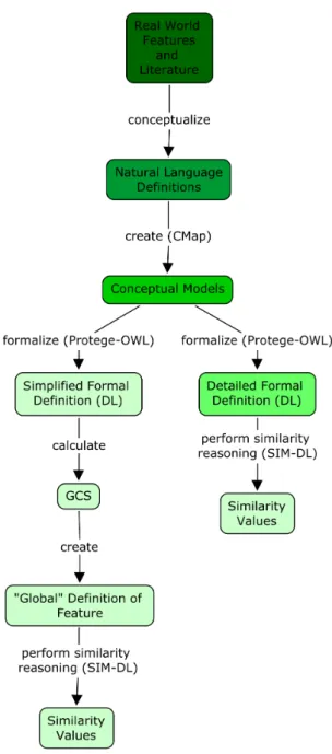
A flow chart outlining the methodology employed in this work is shown in Figure
3.1. This methodology demonstrates how each E.U. member state can create its own microtheory for features to be used in INSPIRE based on existing natural language definitions. The upper-level, ’global’ definition could be used as a guide and as a default microtheory should a country not have created its own.
3.2
Geographic Feature Scenarios
This work focuses on the definition of rivers, forests and estuaries throughout Eu-rope. These features were chosen to best demonstrate the benefits of the microtheories approach as they are highly dependent on geographic conditions including climate, to-pography and biogeography. Thus, their characteristics and conceptualizations vary from place to place. Their definition is often subject to conceptual vagueness and they are prone to multiple conceptualizations.
Rivers, forests and estuaries cover large areas and produce many environmental and commercial goods and services. They are of high importance from economic, social and environmental perspectives and have many stakeholders. The ability to understand, study and effectively manage these features is of the utmost importance. Information sharing between stakeholders, facilitated by an SDI, is fundamental to achieving this aim.
Figure 3.1: Flow chart showing the steps taken to arrive at the ’global’ level microtheory for each geographic feature. Decreasing color intensity indicates decreasing expressivity of the language used.
chosen in order to capture the array of different forest types across Europe and because they employed comparable parameters in their legal definitions of forest. Norway and the Netherland’s were chosen as case studies for the estuary scenario as they provide stereotypical examples of two contrasting estuary types (fjord and bar-built). It is im-portant to remember that the characteristics of features may vary across the country and the definitions represented here reflect only the most common conditions. The im-plications of this and ways to overcome it using microtheories are discussed in section
5.2.2.
3.3
Structuring Microtheories
The structuring of microtheories refers to the way they are related to one another and the granularity of reference of a single, ’local’ microtheory. It is important to choose a structuring principle that is effective from ontological, geographic, cultural and political perspectives. In Cyc microtheories are usually related to one another hierarchically, using a generalization relationship (refer toCycorp (2002b)). This creates an ordered set of microtheories such that more specific ones are subsumed by more general ones. The potential of structuring of microtheories using other ordering principles such as space, time or cultural background have received virtually no attention in the semantic Web community.
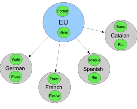
An exception isJanowicz (2009) who suggests further research into the use of mi-crotheories, structured by time and space, to harmonise heterogeneous data sources based on differing ontological assumptions. In this work, individual microtheories can be thought of as local ontologies (discussed byUschold(2000)). The following discusses the potential use of microtheories structured based on spatial (geographic, climatic and administrative) and cultural or linguistic boundaries, with respect to the INSPIRE ini-tiative. Figures 3.2, 3.4 and 3.5 illustrate the proposed ’global’ level, Europe-wide microtheories for geographic features (in blue) and the different possible structuring methods for lower level microtheories (in grey). Each feature (represented in green) would be a sub-microtheory to these lower level microtheories.
3.3.1 Cultural and Linguistic Structuring
Multi-lingualism presents a substantial problem to ontology matching and further com-plicates the pursuit of interoperability throughout the EU (Vossen(2008)). The Knowl-edge Yielding Ontologies for Transition-based Organization (KYOTO) recognises the importance of allowing ’experts and non-experts to access information in their own lan-guage, without recourse to cultural background knowledge’ (Vossen(2008)). Adopting cultural or linguistic boundaries as ordering principles (outlined in Figure 3.2) for mi-crotheories could overcome barriers posed by natural language boundaries and very accurately represent conceptualizations across the European Union.
Frank(2009) discusses difficulties translating directly between vocabulary and terms which may hold different connotations from language to language. Mark(1993) demon-strated that different distinctions in physical characteristics are combined to define similar landscape features in French and English. Thus, geographic terms are not strictly able to be translated and the case for language-specific conceptualisations, and microtheories structured around language boundaries, is strong. However, there are numerous factors which would hinder the use of language boundaries as structuring principles for microtheories when defining features across the EU.
The EU has 23 official languages and more than 10 additional unofficial, but widely spoken, languages3
. Often the same language is spoken in different countries where geographic conditions may differ considerably. For example, English is the official language of the UK and Malta which are on opposite sides of the EU and experience vastly different climatic and geographic conditions. Thus, a single ’English’ microtheory would most likely not reflect the conditions in both places well. Also, many countries in the EU have more than one official language overlapping in the same place. From a practical perspective this could cause confusion and unnecessarily complicate the process.
In addition, including more than one language in a single ontology has not, to the author’s knowledge, been attempted. Even using microtheories capable of bearing inconsistencies, it may not be possible given the present state of technology. Future research in this direction would be useful.
3
Figure 3.2: Example of language-based structuring for geographic feature microtheories.
3.3.2 Spatial Structuring
Tobler’s First Law of Geography states that ’Everything is related to everything else, but near things are more related than distant things’ (Tobler (1970)). Climatic, geo-graphic and geological factors, all of which adhere to the above law, govern the character of geographic features. Thus, it is probable that they also influence how these real-world features are conceptualized. As INSPIRE aims to create a Spatial Data Infrastructure it makes sense that the conceptualizations of geographic entities be structured using spatially relevant principles.
3.3.2.1 Climatic Boundaries
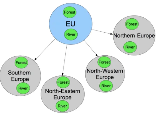
Figure 3.3shows the climatic regions across Europe. These were used as guidelines to produce the structuring divisions suggested in Figure 3.4. Southern Europe coincides with subtropical dry summer and semiarid climatic zones including most of Spain, Portugal and Italy. The North-Western Europe microtheory would represent the humid oceanic climatic zones of France, Germany, the UK and part of Norway. Eastern Europe covers the many countries identified as humid continental zones (Figure 3.3) while the Northern Europe microtheory includes the northern parts of Norway, Sweden and Finland.
Using this structuring method some countries would belong to more than one mi-crotheory group. For example, Spain would be included in the North-Western and Southern Europe microtheories and Germany would be represented half by the North-Eastern and half by the North-Western European microtheory. Thus, using climatic boundaries as the structuring unit for microtheories across Europe would also require numerous countries, with very different cultures and languages, to agree on a single conceptualisation. The North-Eastern Europe microtheory, for instance, would require agreement between more than 15 countries on conceptualisations of geographic features. This would be virtually no different to the standardization of feature definitions across the entire EU and would create complexities and be politically difficult to coordinate and implement in practice.
In addition, each area captured in the climatic structured microtheories is very large and likely to possess local heterogeneity not captured using this broad-scaled structuring system. Many complex factors, including topography and land cover, induce spatial climatic variations at a local and regional scale (Thomas and Herzfeld(2004)). For example, some valleys in the inner Alps, have vastly different climatic regimes due to orographic lifting and the rain shadow effect controlling precipitation in the area. These factors are likely to be reflected in the character of many geographic features in the area.
3.3.2.2 Administrative Boundaries
Figure 3.3: Climatic Zones of Europe4
.
Although administrative boundaries do not reflect climatic and geographic boundaries completely they do break the problem to a smaller size and are intuitive divides from a political perspective. Under this method each EU member state would be free to have its own microtheory, best reflecting conditions and legislation in its country. It is likely to be politically achievable and align well with present data models which are usually nationally created.
microtheory splits. Administrative containment is the structuring approach used in this work.
Figure 3.5: Example of administration-based structuring for geographic feature microtheories.
3.4
Natural Language Definitions
Having decided upon administrative boundaries as the most effective microtheory struc-turing method for the INSPIRE scenario, expressive natural language definitions for each geographic feature were derived in consultation with numerous sources. To create intuitive and practical definitions and overcome some of the challenges discussed in section 2.2.3, many characteristics were included. In this work, geographic features in different countries were defined based on their physical parts (the endurants of which they consist),qualities(their measureable attributes), theirparticipation in perdurants, and theirroles.
3.5
Conceptual Modelling
The natural language feature definitions were expanded into semi-formal conceptual models mapping the relations between entities in the domain. IHMC CmapTools5
was used to create the conceptual models.
3.5.1 Top–level Ontology Alignment
It is widely accepted that to create a coherent, systematic and complete ontology (and microtheory) it should be aligned to a foundational (top–level) ontology (Schneider
(2003); Frank(2003a)). Top–level ontologies specify the meanings of important, over-arching, domain–independent entities in the real world and the relationships between them (Bittner et al.(2009)). They provide a ’common neutral backbone’ from which more specific domain ontologies can be built (Smith(2003)).
Currently several top–level ontologies exist (e.g. DOLCE (Masolo et al. (2003)), BFO (Spear (2006)) and SUMO (Niles and Pease (2001))). This work was loosely aligned to DOLCE (Descriptive Ontology for Linguistic and Cognitive Engineering) as the top level ontology (Masolo et al.(2003)). DOLCE aims to negotiate the meaning of entities at a foundational level which will enable co–operation and consensus between humans and artificial agents (Gangemi et al.(2002)). It is recommended for use in the creation of spatial ontologies6
. Klien (2008) states that DOLCE’s cognitive bias and its top-level notations make it particularly suited to representing geographic entities.
DOLCE divides all things (particulars) into four categories Endurant, Perdurant, Quality and Abstract (Gangemi and Mika (2003)) (the taxonomy of DOLCE basic categories is shown in Figure 7.2 of the Appendix). Endurants are entities which are present, in full, at any time that they are present, while perdurants are processes which extend through time by accumulating different temporal parts. Thus, perdurants are only partially present at any time as their past and future ’parts’ are not present at all times (Gangemi et al. (2002)). Physical endurants have a clear spatial location, while the spatial location of perdurants is determined by the endurants which participate in them. Qualities are basic entities that can be perceived or measured (Masolo et al.
(2003)). The notion of roles, as they are discussed here, refers to ’functional roles’ recognised in DOLCE (Masolo et al.(2003)).
These categories were taken into account during conceptual modeling and entities
5
http://cmap.ihmc.us/conceptmap.html
6
are divided broadly between DOLCE’s upper-level classes. However, the microtheories presented here were not directly aligned to DOLCE for the following reasons. The direct alignment of a geographic feature ontology to the DOLCE categories requires an intermediate ’core’ or ’domain’ ontology (Klien (2008)). A satisfactory core ontology does not yet exist for the geographic domain. Direct alignment would also mean that each microtheory is considerably larger and more complex. In addition, the ambiguity of geographic features creates some difficulty when attempting to align them with the upper-level classes defined by DOLCE (Duce(2009)).
3.5.2 Ontology Grounding
In addition to top-level alignment, it is argued that practical ’grounding’ of ontologies in real-world measurements will better clarify inter-domain similarities between entities and help overcome vagueness (Mallenby (2007); Scheider et al. (2009); Kuhn (2009)). Measureable attributes often help to define and distinguish features (Mallenby(2007)) (e.g. level of salinity and depth help define the type of estuary). Thus, to establish more meaningful semantics and interoperability the measurable qualities of entities (e.g. water depth, water quality etc...) were included in the conceptual models with the intention of linking them with ’measurement ontologies’ currently under creation (refer toKuhn (2009);Scheider(2009)).
3.6
Formalization
The conceptual models were formalized into the Web Ontology Language (OWL). OWL is an expressive knowledge representation language, based on Description Logic (DL). It adopts the open world assumption (i.e. the knowledge base does not contain all there is to know and a statement is not necessarily untrue just because it is not contained in the KB) and is also free from the unique name assumption (Horridge et al.(2004)). OWL is compatible with the architecture of the World Wide Web and the Semantic Web (McGuinness and van Harmelen(2004))and is endorsed by the World Wide Web Consortium (W3C) (W3C(2007)).
3.3.1 was employed for the similarity reasoning as it provides plug-ins to the SIM-DL reasoner.
Note that in this work local definitions of each feature were represented in a single ontology to allow reasoning in Prot´eg´e. In fact, they are in separate microtheories and hence are all named appropriately (i.e. SpanishRiver, GermanRiver). Difficulties arising from semantic heterogeneities are captured by this approach as all definitions have an administrative scope.
3.6.1 Computation of the Global Level
Once the local, member state specific, conceptualizations were formalized, it was pro-posed to employ the reasoner to compute the common, global level definition for each feature type. Least common subsumers (LCS) are concepts or restrictions that are common to the definition of different entities in an ontology. The LCS of concepts represents the most specific concept which subsumes all the concepts. This inference technique has been suggested to facilitate a bottom–up approach to knowledge base con-struction (Baader and Kuesters (1998);Baader et al.(2007);Janowicz et al. (2008c)). In this work, the LCSs were intended to determine the intersection between different local microtheories defining the same feature. The elements of commonality in each microtheory will be used as a global definition of the geographic feature which is neither too broad nor too narrow.
It is important to note that present methods for computing LCS are restricted to inexpressive description logics which do not allow for disjunction (i.e. the use of the union operator) in concept definitions (Baader et al. (2007)). In such cases the LCS would simply be the disjunction of the collection of concepts which does not reveal anything new and does not well represent a common global definition. As the definitions for geographic features presented here rely heavily on the use of disjunction to produce intuitive definitions this is unsuitable.
calculated by hand in accordance with the generic rules defined below.
First, in order to determine where to apply each rule, the normal form of concept definitions in each microtheory was defined. This ensured that the correct correspond-ing parts of each siblcorrespond-ing microtheory would be compared when calculatcorrespond-ing the GCS i.e. therolesdefined for a SpanishRiver would be compared with therolesdefined for a Ger-manRiver and so on. A conjunctive normal form was used. It was structured as follows:
GeoF eature≡Roles(GeoF eature)⊓P hysicalP arts(GeoF eature)⊓Qualitaties(GeoF eature)
Roles(GeoF eature) is a disjunction of possible roles for the geographic feature, and
P hysicalP artandQualitatiesare conjunctions of concepts related to the physical and
qualitative properties of the geographic feature.
The generic rules applied to the normal form concepts of two microtheories to compute the good common subsumer (GCS) are listed below with examples:
• Roles.All disjunct roles of each microtheory will be vivified back to their nearest
common super–role. mt1 :∃R1⊔R2
mt1 :∃R1⊔R2⊔R3
GCS:∃R
WhereR is the nearest common super–role ofR1, R2 and R3.
• PhysicalParts. Elements belonging to the PhysicalParts part of the definition
will be present in the GCS only if they are shared by both microtheory concepts. If they are restrictions, and the same physical part is not shared they will be vivified back to their nearest common superclass (NCS).
mt1 :∃P.F ⊓ ∃P.C
mt2 :∃P.F ⊓ ∃P.B
GCS:∃P.F ⊓ ∃P.A
WhereA is the nearest common superclass ofC andB.
• Qualities.When nominal, qualitative or numeric threshold values are included as
the fillers in restrictions, the GCS is created using the nearest common superclass, as long as both microtheories have the same defined hierarchy over these nominals. Otherwise, a filler is created with the union of the nominals.
mt1 :∃P.Spain
mt2 :∃P.Germany
GCS:∃P.M emberState
if there exists a common hierarchy with member states in both microtheories.
3.6.2 Classifying Instances
The built–in FaCT++ (Fast Classification of Terminologies) (Horrocks (2003)) Rea-soner in Prot´eg´e 4 was used to infer a class hierarchy and check the consistency of the ontologies. It was also employed to test if the restrictions were sufficient to allow the reasoner to correctly classify instances which it had been given.
3.7
Similarity Reasoning
Similarity reasoning between concepts in an ontology can be used to assess how well the definitions capture the domain and reflect human conceptualizations (Janowicz et al.
(2008a)). SIM-DL7
is an asymmetric, context-aware similarity measurement theory used for information retrieval (Janowicz et al.(2007)). It compares a DL search concept with one or more target concepts, all in canonical form, by measuring the degree of overlap between their definitions. A high degree of overlap indicates high similarity (refer toJanowicz et al. (2007) for a detailed description).
SIM-DL was ideal for use in this work as it does not require a populated ontology, can handle the expressivity of different description logics and has an intuitive user in-terface (Janowicz and Wilkes(2009)). SIM-DL has the added functionality of allowing the ontology creator to estimate the similarity of concepts based on their own concep-tualization or the concepconcep-tualization of experts in the field (Janowicz et al. (2008a)). This estimated similarity can then be compared to the calculated similarity between the defined concepts in the ontology. This gives an indication of how well the ontology captures the conceptualization of the real world. Similarity using SIM-DL has been suggested to improve the intuitiveness of information retrieval in SDIs (Janowicz et al.
(2008c))
The similarity value calculated by SIM-DL is sensitive to the context which is defined, the way the conceptualization is defined and the relationships used. Therefore, the ontologies had to be created specifically for use with the SIM-DL reasoner and could not contain instances. The restrictions used to define concepts had to be given in the same order and use the same properties etc... The overall similarity between concepts
7
is the normalized sum of the similarities for all parts (i.e. restrictions, subconcepts and superconcepts). A single similarity value is not indicative of absolute concept similarity and can only be considered relative to the other similarity values. Thus, SIM-DL delivers a normalized similarity ranking and orders the concepts from most (a similarity value of 1.0) to least (a similarity value of 0.0) similar.
Similarity reasoning was used in this work for two purposes:
1. To determine if the EU wide definitions created based on the GCS were appro-priate and would allow a search to retrieve data from all member states and to see if this is also the case for the definitions provided by INSPIRE and other organizations (e.g. FAO and BOS).
2. To provide some indication of how well the local microtheories defined for the feature types, represent how those features are intuitively conceptualized.
To achieve these aims the SIM-DL similarity server was run using the maximum and asymmetry modes. When concepts are composed by disjunction, SIM-DL distin-guishes between maximum and average similarity modes. The maximum similarity mode computes the similarity value between two concepts using the most similar con-cept that is part of the disjunction (Janowicz et al.(2007)). As the concept definitions in this work relied heavily on the use of the union-operator (disjunction) this was the most appropriate setting to illustrate the level of similarity between two concepts. The defaultasymmetry setting of SIM-DL means that the direction in which concepts are compared also affects the results (i.e. the similarity betweena and bis not necessarily equal to the similarity betweenb and a).
To achieve the first aim, the EU wide definitions were compared to the local defi-nitions and the defidefi-nitions of other organizations (e.g. INSPIRE, BOS and FAO) and the similarity between them calculated. Ideally, in the context of searching, the sim-ilarity between the broadest term which is the search term (in this case the EU wide definition) and the intended terms (in this case the local definitions) should be 1.0. If this is the case a search for the broad term, in a semantics-enabled interface for Web gazetteers or Web Discovery Service in INSPIRE, would return all the intended terms and satisfy the user’s requirements. A lower similarity value may or may not return all desired results depending on the similarity threshold defined (as discussed inJanowicz et al. (2008c)).
As experts in the field were not available, the estimations of similarity between forest definitions were made by the author, based on the geographic proximity of the coun-tries (given Tobler’s 1st law of geography (Tobler (1970))) and the author’s personal conceptualization of the features in each country. In the forest scenario three different ontologies were compared. The initial one was the standard ontology created and used in the calculation of GCS. The second was the standard ontology with the ’roles’ re-moved. The standard ontology was then enriched by adding details of dominant forest types in each country to see if this improved the definitions of forest by making them more intuitive and better correlated with the estimated similarities.
In contrast to previous work using SIM-DL (e.g. Janowicz et al. (2008a,c)), this work compares different conceptualizations of thesame feature (e.g. forests in Austria and forests in Spain), not different features (e.g. river and lake (Janowicz et al.(2008a)).
3.8
Conclusion
Chapter 4
Application and Results
This section describes the application of the methodology, outlined in the previous chapter, to the scenarios of rivers, forests and estuaries to calculate an appropriate Europe-wide definition for each feature and test the merits of the microtheory approach. The outcomes of similarity reasoning performed on each feature are then described.
4.1
Rivers
The law is not so much carved in stone as it is written in water, flowing in and out with the tide. Melvoin(1992)
It was decided to focus on the scenario of rivers as their conceptualization (Mark(1993);
Pires et al.(2005)) and formalization (e.g. Santos et al.(2005);Mallenby(2007);Hart et al.(2007); Bennett et al. (2008) and Janowicz et al.(2008a)) has been well treated in the literature. In addition, they are highly sensitive to climatic and environmental factors and thus vary in character across Europe.
The traditional northern European perspective of rivers is of a continuously flowing body of water which may also be navigable (Taylor and Stokes (2005)). This view is reflected in the INSPIRE Consolidated UML Model’s1
, Hydrography theme. In this classification river is not explicitly defined. Instead, the broader class watercourse is defined as ’A natural or man–made flowing watercourse or stream’2
. The European Water Framework Directive (WFD)3
is a Europe-wide water legislation governing the
1
http://inspire-twg.jrc.ec.europa.eu/inspire-model/Generated 24 August 2009 (v3, Revi-sion 873)
2
http://inspire-registry.jrc.ec.europa.eu/registers/FCD/items/105
3
quality, monitoring and reporting of all inland and coastal waters. The WFD definition for river is also included in the INSPIRE FCD as it is regarded as a candidate spatial object for Annex III theme ’Area Management...’. The WFD defines a river as ’[a] body of inland water flowing for the most part on the surface of the land but which may flow underground for part of its course’4
. The British Ordnance Survey (BOS) Hydrology Ontology5
adopts a more detailed definition but still requires flowing water while the Environment Ontology (EnvO)6
only contains the restriction that rivers contain water.
These definitions seem broad, however, their requirement of flowing water, or at least water, may be too specific to encompass some rivers in the Mediterranean climes of southern Europe - especially taking the effects of global warming into account. For example, some rivers in southern Spain are highly ephemeral and may contain water (let alone flowing water) only for short periods coinciding with floods or strong rainfall events. In these regions, the conceptualization of river includes channels or depressions through which water flows, even if they are dry and do not show distinct banks (Lamaro et al. (2007)).
4.1.1 Natural Language Definitions
Rivers in Spain and Germany are defined below in natural language. The terminology used is in accordance with that found in the WFD or documents from the relevant national governing body. Fundamental differences between the two definitions are ob-vious.
Spanish River A river in Spain is defined as a channel, with a bed and more or less
defined banks, which transects a river basin at a low point in the topography. It drains water which falls as precipitation on the river basin. It has a flow regime which refers to the average presence or absence of water within the channel throughout a year. It may participate in flood events and provides the ecological service of protecting against these events. Spanish rivers can provide terrestrial or aquatic habitat and terrestrial or aquatic recreational areas and play the role of supplying water and transportation.
German River A river in Germany is defined as a channel, with a river bed and river
banks, which contains flowing water, transects a river basin and has another waterbody as its destination. It represents the above ground expression of the groundwater table