1
Introduction
The relation with the place where we develop our activities and interact with our social networks draws important interest to the comprehension of the daily citizenship context. Different places satisfy different needs, becoming targets of attachment or meaning for different reasons, even in globalized world (Lewicka, 2011). A person is not ‘located’ in an environment, conversely, a person constructs a position in that environment. Furthermore, this relationship can clearly also be influenced by the dwellers of target-attachment place (Bernardo & Palma-Oliveira, 2016) and social relationships. Therefore the attitudes, feelings and behaviors towards a certain geographical area (sense of place) (Jorgensen & Stedman, 2001) and to human collectives (social capital) are defining, to some extent, the form of how citizens understand the urban context.
A positive sense of place (SOP) has been linked to an improved life quality (Harris, Werner, Brown, et al., 1995), and to engaging more citizens into participatory processes. In turn, social capital (SC) is a building block of collaboration, community’s cohesion and civility (Lewicka, 2005). Psychological factors explain what motivates to participate and how to maintain that participation (Perkins, Hughey & Speer, 2002). Therefore, SOP and SC are important factors for civic engagement (CE), which underlies how citizens are related to issues of public concern. SOP, SC and CE cover a vast amount of basic environmental and community psychological dimensions between citizens and cities, respectively. SC can
also be conceptualized as bonding SC – strong ties - (within a community or place-based social interactions) and bridging SC – weak ties - (horizontal links among heterogeneous actors). There are several types of research about who and how much is attached to a place, but we know little about where these meaningful relationships and places are (Lewicka, 2011). There are few, limited tools and guidelines to explicitly spatialize SOP and SC. For example, the SC spatial dimension can be embedded in the cognitive neighborhood (Foster, Pitner, Freedman, et al., 2015) or extracted from social network analysis (Andris, 2016; Valenzuela, Park & Kee, 2009) from a structuralist point of view.
Recently, Jenkins et al. (2016) merged twitter data and Wikipedia geolocated data to spatialize a collective SOP, being the first research merging social network analysis and volunteered geographic information (VGI) to define SOP. Brown and his colleagues focused on measuring landscape values and SOP for scales larger than a neighborhood, including the first research on mapping place attachment through an Internet-based Public Participatory Geographic Information System (PPGIS) application (Brown, Raymond & Corcoran, 2015). Currently, the surge of Information and Communications Technologies (ICT) is allowing new ways for interactions to gather SOP and SC spatial dimensions. Furthermore, the combination of ICT technologies with Geographic Information Science (GISc) framework and tools are offering new possibilities to gather psychological and social concepts from a geographical perspective. However, GISc- Albert Acedo
NOVA IMS, Universidade Nova de
Lisboa Campus de Campolide, Lisboa [email protected]
German Mendoza GEOTEC - INIT - Universitat Jaume I Av. Vicente Sos Baynat s/n, Spain [email protected]
Marco Painho NOVA IMS, Universidade Nova de
Lisboa Campus de Campolide, Lisboa [email protected]
Sven Casteleyn GEOTEC - INIT - Universitat Jaume I Av. Vicente Sos Baynat s/n, Spain [email protected]
Abstract
The spatialization of social concepts in to the city context is becoming a need. However, currently, there are few tools to directly spatialize environmental psychology concepts, such as sense of place, or social and participatory concepts, such as social capital and civic engagement. Furthermore, most existing tools are not taking full advantage of Geographical Information Science (GISc) capabilities mixed with online possibilities. This article presents a tool - an internet map-based application with an intuitive user interface - to deal with the pervasive lack of spatializing subjective citizens’ feeling, perceptions and experiences. Our approach successfully merges GISc framework and tools with questions and indicators from literature in social concepts. As such, the tool allows to identify and spatialize sense of place, social capital (discerning between bonding and bridging) and civic engagement of citizens, and attach meaningful information to them. It is a first step towards understanding and studying the social-spatial layer which undeniably ties a city and its citizens together.
based online tools and techniques to spatialize social concepts are at a very early stage.
This article presents a tool to render space as a subjective place that covers the people's feeling toward places and human relationships. We present a new approach 1) to spatialize SOP, SC and CE; 2) to investigate the predictors of the former and; 3) to discern between bonding and bridging SC. This article wants to highlight the role of GISc and its related tools in satisfying this pervasive demand of citizen social information, fulfilling the lack of a social-spatial layer in the city context, by mapping subjective citizens’ feeling and experiences.
2
Fishing with a net: spatializing sense of
place, social capital and civic engagement
Our work aims at directly obtaining the spatial dimension of SOP, SC and CE. Previous works have addressed similar goals using Internet map-based techniques (Brown, Raymond & Corcoran, 2015) for place attachment spatial dimension, geo-questionnaires (Jankowski, Czepkiewicz, Młodkowski, et al., 2016) for land use planning and Jorgensen and Stedman (2011) studies the spatial variation on SC and SOP as matching spatial dimensions. Furthermore, social scientists who are commonly working on related topics use traditional techniques such as personal interviews, hand-written surveys, which are not easily scaled up. Our approach take advantage from GISc, online technologies and platforms to create a novel tool to identify and spatialize sense of place, social capital and civic engagement of citizens that can be harnessed by other social research topic and use at any scale.
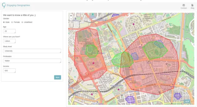
Our tool is provided as a web-based application that guides the user through three processes. Each process gathers relevant data for SOP, SC and CE determination, respectively. In this methodology, the first step is to define the SOP and SC
1
http://leafletjs.com visited on 03/02/2017
geographic areas to be characterized, and later the attention of the user is focused in the previously created area. Our approach responds to the "SoftGIS" methodology (Rantanen & Kahila, 2009), because our collected data assembles environmental psychology data, local experiences and everyday behavior (Kahila & Kyttä, 2009). Our novel interface design (Figure 1) immerses users in a spatial environment, dividing the application layout in instructions and questions (left side) and the map representation with spatial tools (right side). The tool can work both on desktop and mobile environment, but the drawing part performs easier in the former. By splitting the interface design in two parts, we are always showing the area about which the users are being asked about.Simultaneously, users always have a spatial representation available related with their SOP, SC or CE.
Figure 2 presents an outlook of our tool software organization. A thin Html/JavaScript client rendered by a web server presents the user with responsive and intuitive interfaces. The map operations are implemented using Leaflet1. The data provided by the users is sent to a java-based web service and stored in a MongoDB database. Additionally, the client communicates with the Overpass API2 in order to gather relevant place indicators for the areas defined in each process (SOP, SC and CE). The data gathered from Overpass can later be used for comparing with areas characterization done by citizens.
2.1 Sense of place, social capital and civic
engagement: the gathering.
SOP explains the cognitive, affective and behavioral dimensions of the relation that an individual has towards a certain geographical area (Jorgensen & Stedman, 2001).
The first approach to define the individuals’ SOP is to map their significant areas. This article uses the conceptualization
2
http://wiki.openstreetmap.org/wiki/Overpass_API, visited on 03/02/2017.
Figure 2: Our tool’s software organization.
from Jorgensen and Stedman (2001) to create the instruction for drawing citizens’ significant areas. The user is guided by the statements presented in Figure 1.
The second step is to characterize and assess the structure and intensity perception of these areas by citizens. We use non-spatial measures to evaluate and characterize each area. This characterization of SOP’s areas are based on Cilliers and Timmermans (2014) research. They took the four key attributes from the organization Project for Public Spaces (PPS)3. They argue that there are four key attributes connected with intangibles and tangibles variables for describing the nature of a place. Thus, we define these four indicators (see Figure 3). A user can then define the intensity of each index related to the area that is shown in the application interface.
Figure 3: SOP representation and characterization with questions based on Cilliers and Timmermans (2014).
SC refers to the relations between human collectives and the interactions that arise as fruits of these connections through, for instance, trust, reciprocity and cooperation.
The spatialization of SC follows a methodology similar to the SOP. Our approach to spatialize SC is based on the structuralist perspective that highlights the connection that an individual has to others (social networks). Therefore, we want to spatialize the meaningful groups or organizations, network or associations to which a citizen belongs. These could be formally organized groups (religious groups, familiar groups, sports teams, workplace groups, etc.) or just groups of people who get together on a regular basis to do an activity or just chat. Due to the clear network nature, it is possible to draw different areas
3https://www.pps.org/reference/grplacefeat/visited on 03/02/2017.
for each group, thus achieving a network of places that shape the SC of a given group. The novel approach that our application introduces to the social domain is the possibility to characterize each citizen’s group as bonding or bridging SC. Therefore, our application presents the opportunity to spatialize people meaningful relationships and characterize them into weak and strong ties (see Table 1).
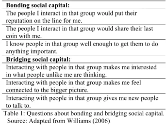
Bonding social capital:
The people I interact in that group would put their reputation on the line for me.
The people I interact in that group would share their last coin with me.
I know people in that group well enough to get them to do anything important.
Bridging social capital:
Interacting with people in that group makes me interested in what people unlike me are thinking.
Interacting with people in that group makes me feel connected to the bigger picture.
Interacting with people in that group gives me new people to talk to.
Table 1: Questions about bonding and bridging social capital. Source: Adapted from Williams (2006)
CE is a process of citizens’ involvement with their society and their government to address issues of public concern, improve conditions of others and help the community.
Our approach to measure and spatialize civic engagement is twofold. On one hand, we want to know the citizen level of participation in city participatory processes and on the other hand, we ask to draw the areas where the citizen wants to be involved in participatory and collaborative practices. Brown et al. (2015) highlight the need to differentiate between those places where we have an attachment and those where we would volunteer or work to improve their conditions. Although there is literature connecting SOP and SC with the CE concept, our application tries to spatialize each concept independently to allow the study of the spatial relations of each concept from individual or block level.
2.2 Engaging the citizen
participation. The latter is considered because participation is likely to occur in small-group situations, where participants know each other (Rydin & Pennington, 2011).
3
Discussion
This paper presents an application to spatialize SOP, SC and CE. To the best of our knowledge, this is the first application that attempts to spatialize the spatial dimensions of these three concepts using an internet-based platform and GIS techniques. Furthermore, it is also the first methodology to explicitly and directly spatialize social capital, without using a moderator or dimensions to measure it. The outcomes from our application can help to clarify current issues that researchers are trying to tackle. For example, the spatialization of SC can intersect with the research from Westlund et al. (2010). In that paper, they emphasize two problems in the conceptualization of SC in a spatial perspective: the level-dependence subjected to the scale of study (bridging in local scale can become bonding in the city context) and the spatial level the respondents refer to when they answer questions about social capital dimensions. Our application deals with both problems assessing the level-dependence nature of the areas through data gathered from Overpass and always asking the questions pointing to an area defined beforehand. Although the application follows an intuitive flow, we will test (1) the application’s usability and 2) if the abstract concepts embedded in the map-web survey are fully understood with the current questions formulation.
For city councils and governments, our application can give useful data, because it allows them to understand the city in terms of meaningful areas for their citizens, and where the social interactions take place, in general, in the city context. Besides, our application introduces an interesting perspective
by directly asking citizens in which places they want to be involved in participatory processes. This simple spatial question can give valuable information to know how and where people want to be involved in participatory processes. This investigation also contributes to the emerging movement of spatializing environmental and social psychological concepts. Insights into how to spatialize the SOP and SC concepts can offer a unique qualitative perspective for a better understanding of their spatial relation and, simultaneously, how they are spatially related with potential areas of CE. Future research will focus on understanding the spatial relation between SOP, SC and CE at the individual level, attempting to find new communities of place and new areas of interaction. Therefore, we claim that GISc provides an appropriate conceptual framework to develop suitable spatial tools and map-based surveys (PPGIS) for the spatialization of concepts from social science (SC) and environmental psychology (SOP).
4
Acknowledgement
Albert Acedo Sánchez gratefully acknowledges funding from the European Commission through the GEO-C project (H2020-MSCA-ITN-2014, Grant Agreement Number 642332, http://www.geo-c.eu/). Sven Casteleyn is funded by the Ramón y Cajal Programme of the Spanish government, grant number RYC-2014-16606.
5
References
Andris, C. (2016) Integrating social network data into GISystems. International Journal of Geographical Information Science. [Online] 8816 (April), 1–23. Figure 4.Presenting the areas that the user has provided. Red color is related to SOP, green to
Available from: doi:10.1080/13658816.2016.1153103. Bernardo, F. & Palma-Oliveira, J.-M. (2016) Identification
with the neighborhood: Discrimination and neighborhood size. Self and Identity. [Online] 15 (5),
579–598. Available from:
doi:10.1080/15298868.2016.1178665.
Brown, G., Raymond, C.M. & Corcoran, J. (2015) Mapping and measuring place attachment. Applied Geography. [Online] 5742–53. Available from: doi:10.1016/j.apgeog.2014.12.011 [Accessed: 3 January 2015].
Cilliers, E.J. & Timmermans, W. (2014) The Importance of Creative Participatory Planning in the Public Place-Making Process. Environment and Planning B: Planning and Design. [Online] 41 (3), 413–429. Available from: doi:10.1068/b39098.
Foster, K.A., Pitner, R., Freedman, D.A., Bell, B.A., et al. (2015) Spatial Dimensions of Social Capital. City & Community. [Online] 14 (4), 392–409. Available from: doi:10.1111/cico.12133.
Harris, P.B., Werner, C.M., Brown, B.B. & Ingebritsen, D. (1995) Relocation and privacy regulation: A cross-cultural analysis. Journal of Environmental Psychology. [Online] 15 (4), 311–320. Available from: doi:10.1006/jevp.1995.0027.
Jankowski, P., Czepkiewicz, M., Młodkowski, M. & Zwoliński, Z. (2016) Geo-questionnaire: A Method and Tool for Public Preference Elicitation in Land Use Planning. Transactions in GIS. [Online] 20 (6), 903– 924. Available from: doi:10.1111/tgis.12191.
Jenkins, A., Croitoru, A., Crooks, A.T. & Stefanidis, A. (2016) Crowdsourcing a Collective Sense of Place. Plos One. [Online] 11 (4), 1–20. Available from: doi:10.1371/journal.pone.0152932.
Jorgensen, B.S. & Stedman, R.C. (2011) Measuring the spatial component of sense of place: a methodology for research on the spatial dynamics of psychological experiences of places. Environment and Planning B: Planning and Design. [Online] 38 (5), 795–813. Available from: doi:10.1068/b37054.
Jorgensen, B.S. & Stedman, R.C. (2001) Sense of place as an attitude: lakeshore owners attitudes toward their properties. Journal of Environmental Psychology. [Online] 21 (3), 233–248. Available from: doi:10.1006/jevp.2001.0226 [Accessed: 12 June 2015]. Kahila, M. & Kyttä, M. (2009) SoftGIS as a Bridge-Builder in
Collaborative Urban Planning. In: Planning Support Systems Best Practice an d New Methods. [Online]. p. Available from: doi:10.1007/978-1-4020-8951-0. Lewicka, M. (2011) Place attachment: How far have we come
in the last 40 years? Journal of Environmental Psychology. [Online] 31 (3), 207–230. Available from: doi:10.1016/j.jenvp.2010.10.001.
Lewicka, M. (2005) Ways to make people active: The role of place attachment, cultural capital, and neighborhood ties. Journal of Environmental Psychology. [Online] 25
(4), 381–395. Available from:
doi:10.1016/j.jenvp.2005.10.004.
Newman, G., Zimmerman, D., Crall, A., Laituri, M., et al. (2010) User-friendly web mapping: lessons from a citizen science website. International Journal of
Geographical Information Science. [Online] 24 (12),
1851–1869. Available from:
doi:10.1080/13658816.2010.490532.
Perkins, D.D., Hughey, J. & Speer, P.W. (2002) Community psychology perspectives on social capital theory and community development practice. Journal of the Community Development Society. [Online] 33 (1), 33– 52. Available from: doi:10.1080/15575330209490141. Rantanen, H. & Kahila, M. (2009) The SoftGIS approach to
local knowledge. Journal of environmental management. [Online] 90 (6), 1981–1990. Available from: doi:10.1016/j.jenvman.2007.08.025 [Accessed: 9 January 2015].
Rydin, Y. & Pennington, M. (2011) Public Participation and Local Environmental Planning : The collective action problem and the potential of social capital. Local Environment: The International Journal of Justice and Sustainability. [Online] 5 (2), 153–169. Available from: doi:10.1080/13549830050009328.
Valenzuela, S., Park, N. & Kee, K.F. (2009) Is There social capital in a social network site?: Facebook use and college student’s life satisfaction, trust, and participation. Journal of Computer-Mediated Communication. [Online] 14 (4), 875–901. Available from: doi:10.1111/j.1083-6101.2009.01474.x.
Westlund, H., Rutten, R. & Boekema, F. (2010) Social Capital, Distance, Borders and Levels of Space: Conclusions and Further Issues. European Planning Studies. [Online] 18
(6), 965–970. Available from:
doi:10.1080/09654311003701506.