Brazilian Journal of Geophysics (2019) 37(2): 163-173 © 2019 Sociedade Brasileira de Geofísica ISSN 0102-261X
www.scielo.br/rbg
RECOGNIZING LATE CRETACEOUS TO PALEOGENE CHANGES IN RELATIVE SEA LEVEL
IN NORTHERN SANTOS BASIN, BRAZIL
Aurora M. Garcia
1, Cassio A. Pires
1, Daiane Münch
1, Iarema F.P. Carvalho
1, Luiza S. Freitas
1, Lucas A. Valore
1,
Carlos Eduardo Silva
1, Rosana N. Lima
1, Daniel F. Balensiefer
1and Fernando F. Vesely
2ABSTRACT.The stratigraphy of the Santos Basin has become of great interest in the last decade because of the large oil accumulations in pre-salt (rift) and post-salt (drift) strata. Nevertheless, the most accepted stratigraphic models for the drift phase are only at a basin scale and can still be improved by more detailed work. In this paper we analyze an inline seismic section in the modern continental slope of the Santos Basin in order to describe the stratigraphy and to reconstruct relative-sea level (RSL) changes from the Campanian to the Eocene/Oligocene boundary. We mapped 40 seismic horizons, in which clinoform rollovers (former shelf margins) and stratal terminations were recognized. These data allowed for the construction of a chronostratigraphic chart and a RSL curve. The proposed stratigraphic chart displays three lower-order sequence sets comprising higher-order sequences including mostly alternating forced-regressive and normal-regressive system tracts, with the exception of three important transgressive episodes. Higher-order sequences above the intra-Maastrichtian unconformity exhibit low-angle ascending to descending shelf-margin trajectories and frequently truncated topsets, while aggradation was more important during Campanian to Maastrichtian. Expressive mass-transport deposits (chaotic seismic facies) at the bottomsets of some mapped horizons all match with forced-regressive episodes.
Keywords: seismic interpretation, sequence stratigraphy, shelf-margin clinoforms.
RESUMO.A Bacia de Santos tornou-se de grande interesse na última década devido às acumulações de petróleo no pré-sal (rifte) e pós-sal (deriva). No entanto, os modelos estratigráficos mais aceitos para a fase de deriva são em escala de bacia e podem ser incrementados por trabalhos de maior detalhe. Analisamos uma seção sísmica longitudinal no talude continental atual da bacia, a fim de descrever a estratigrafia e reconstruir mudanças do nível relativo do mar (NRM) do Campaniano ao limite Eoceno/Oligoceno. Quarenta horizontes sísmicos foram mapeados, nos quais margens da plataforma (clinoform rollovers) e terminações estratais foram reconhecidas. Esses dados permitiram a construção de um diagrama cronoestratigráfico e uma curva de variação do NRM. Identificou-se três conjuntos de sequências de menor ordem compreendendo sequências de ordem mais elevada, incluindo, na sua maioria, alternância entre regressão forçada e normal, com exceção de três importantes episódios transgressivos. As sequências de maior ordem acima da inconformidade intra-Maastrichtiano exibem trajetórias ascendentes de baixo ângulo a descendentes de margem de plataforma e topsets truncados, enquanto agradação foi mais importante entre o Campaniano e o Maastrichtiano. Depósitos de transporte de massa (fácies sísmicas caóticas) nos bottomsets de alguns horizontes mapeados associam-se com episódios de regressão forçada.
Palavras-chave: interpretação sísmica, estratigrafia de sequências, clinoformas de margem de plataforma.
1Universidade Federal do Paraná, Centro Politécnico, Programa de Pós-Graduação em Geologia, Jardim das Américas, Caixa Postal 19001, 81531-980, Curitiba, PR, Brazil – E-mails: [email protected], [email protected], [email protected], [email protected], [email protected], [email protected], [email protected], [email protected], [email protected]
2Universidade Federal do Paraná, Centro Politécnico, Departamento de Geologia, Jardim das Américas, Caixa Postal 19001, 81531-980, Curitiba, PR, Brazil – E-mail: [email protected]
INTRODUCTION
Seismic investigation of continental margins have improved our knowledge on the stratigraphic evolution of former shelf-margin systems by allowing estimating changes in relative sea level (RSL) and to assess its relationships with slope accretion and the transference of sediment to deep waters (e.g., Vail et al., 1977; Posamentier et al., 1988). More recently, the concept of shoreline and shelf-margin trajectory (e.g., Helland-Hansen & Hampson, 2009) as a tool for reconstructing RSL changes has been widely employed (e.g., Johannessen & Steel, 2005; Carvajal & Steel, 2006; Helland-Hansen & Hampson, 2009; Henriksen et al., 2009). This concept assumes that particular classes of trajectory (i.e., descending regressive, ascending regressive and transgressive) relate to depositional trends that, in turn, are a result of variations in accommodation and sedimentation rates at a given break in the depositional profile (shoreline or shelf-margin). Trajectory analysis can be performed with outcrop, well-log and seismic data. When dealing with seismic sections, shoreline breaks are usually undetected because of the low-resolution. In this case shelf-margin trajectory is often taken as a proxy for RLS change.
In the Santos Basin, offshore southeastern Brazil, seismic interpretations of shelf-margin clinoforms and the application of trajectory analysis allowed, for instance, to observe a direct relationship among RSL fall, slope failure events and the formation of mass-transport deposits during the Eocene (Berton & Vesely, 2016). However, the application of these results as a method for reviewing and refining the stratigraphic chart of the basin (e.g., Modica & Brush, 2004; Moreira et al., 2007; Assine et al., 2008) is still to be done. In this paper we analyze the Late Cretaceous to Eocene interval of northern Santos Basin by mapping the shelf-margin trajectory.
The main goal is to reconstruct RSL changes and to provide more detailed information on the sequence-stratigraphic framework of this basin. The Santos Basin has become the most prolific petroleum province in Brazil, with a total oil production that recently overcame that of the Campos Basin, the historical largest oil province in the country (Fernandez & Santos, 2017). Besides the enormous volumes of high-quality oil accumulations in pre-salt carbonates, post-salt turbidites and shallow marine sandstones hold significant amounts of oil and gas in the central and northern sectors of the Santos Basin (e.g., Sombra et al., 1990; Moreira et al., 2007; Assine et al., 2008; Chang et al., 2008).
GEOLOGICAL SETTING
The Santos Basin, offshore Brazil, is located between the Florianópolis lineament and the Cabo Frio high and is bounded landward by the Serra do Mar range, where Precambrian rocks are exposed (Macedo, 1989; Moreira et al., 2007). It is the largest basin of the Brazilian continental margin (Fig. 1) and formed as a result of Gondwana break-up and the opening of the South Atlantic Ocean. The sin-rift phase (Early Cretaceous) accumulated a thick succession of non-marine clastics and carbonates and corresponds to the time during which the most important oil-prone source rocks (lacustrine shale) and pre-salt reservoirs were deposited.
During the Aptian, a transitional or sag phase is associated with the deposition of extensive evaporitic beds in restricted and intermittent marine waters (Ariri Formation). This thick salt package is believed to have formed in clastic starved troughs that were periodically infilled by marine incursions and seepage waters (Karner & Gamboa, 2007). A submarine volcanic ridge parallel to the rift direction (Walvis – Rio Grande Ridge) played a key role in isolating the evaporitic basins from open waters (Karner & Gamboa, 2007; Mohriak, 2014; Buckley et al., 2015), which likely explains the absence of a salt sequence in the southernmost Pelotas Basin. The subsequent post-rift (drift) stage (Fig. 2) starts with the development of a prominent Albian carbonate platform recording the onset of a net-transgressive marine succession extending until the mid-Turonian (Itajaí-Açu Formation). This was followed by a major Late Cretaceous to Late Eocene regressive phase (Pereira & Macedo, 1990) referred to as the Jureia progradation, which has been associated with an increase in sediment supply due to uplifting and denudation in the Serra do Mar region (e.g., Zalán & Oliveira, 2005). The Eocene/Oligocene boundary records an expressive transgressive event that displaced the shelf-margin several tens of km landward. This transgression has been associated with a drastic reduction of clastic input into the Santos Basin because of the capture of the Paraíba do Sul river system (e.g., Zalán & Oliveira, 2005), one of the main sediment sources to the basin during the Jureia progradation. The post-rift evolution of the Santos Basin was highly influenced by salt tectonics. Subsurface displacement of Aptian evaporites controlled sedimentation by creating enhanced accommodation in salt-withdrawal (extensional) proximal regions and forming inter-dome mini-basins in more distal, compression-dominated areas (e.g., Assine et al., 2008; Quirk et al., 2012; Jackson et al., 2015). Among major salt-related structures, the Cabo Frio fault
GARCIA AM, PIRES CA, MÜNCH D, CARVALHO IFP, FREITAS LS, VALORE LA, SILVA CE, LIMA RN, BALENSIEFER DF & VESELY FF
165
Figure 1 – Location of the study area in northern Santos Basin. Major structural features modified from Assine et al. (2008).
zone (Fig. 1) is a salt-attached, landward-dipping listric fault associated with rollover anticlines and thick growth strata mainly of Late Cretaceous age (e.g., Assine et al., 2008). The Albian gap (e.g., Mohriak et al., 1995; Jackson et al., 2015) is a structural feature related to rafting of Albian shelfal carbonates because of the basinward flow of underlying salt, which created a “gap” where the Albian succession is missing. The Albian gap and the Cabo Frio fault zone are genetically linked and the origin of both structures is due to a combination of gravity-driving salt withdrawal, carbonate rafting and growth faulting triggered by tilting and sediment overloading during the Jureia progradation (e.g., Jackson et al., 2015).
The interval examined in this paper (Fig. 2) corresponds to the upper part of the Jureia progradation (Late Campanian to Late Eocene). It has been previously studied mainly because of high-quality seismic data allowing the description of prograding clinoforms and thick chaotic units (mass-transport complexes) in greater detail. The stratigraphic architecture of the Eocene clinoforms has been analyzed (Moreira & Carminatti, 2004;
Berton & Vesely, 2016) as well as the external and internal framework of recurrent mass-transport complexes (Carlotto & Rodrigues, 2009; Jackson, 2011). Carlotto & Rodrigues (2009) did a detailed 3D characterization of a Maastrichtian mass-transport complex termed by them as the “Maricá slump”, which is located at the lower part of the examined succession.
METHODS AND KEY DEFINITIONS
This study is based on the stratigraphic analysis of a post-stack time migrated, dip-oriented (NW-SE) seismic inline of the BS500 3D seismic survey. A 2D seismic section (survey Santos 18A 0231) was also examined to place the results in a more regional context (Fig. 1). Data were provided by the Brazilian Agency of Petroleum, Gas and Biofuels (ANP). The inline is bounded by the UTM coordinates X=730.082; Y=7.329.496 (proximal edge) and X=740.521; Y=7.303.325 (distal edge), is 28 km long and is located on the modern continental slope of northern Santos Basin in water depths from 879 to 1485 m. The examined interval comprises about 1800 ms (TWT) and is limited at the top by
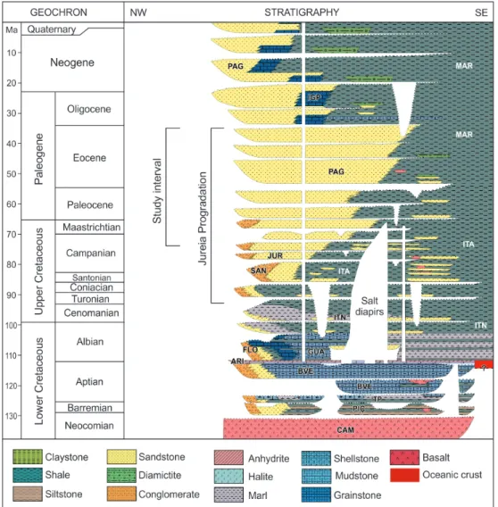
Figure 2 – Stratigraphic chart of the Santos Basin (adapted from Moreira et al., 2007) highlighting the study interval in the context
of the Jureia Progradation. Key for lithostratigraphic names: CAM, Camboriú; PIÇ, Piçarras; ITP, Itapema; BVE, Barra Velha; ARI, Ariri; FLO, Florianópolis; GUA, Guarujá; ITN, Itanhaém; ITA, Itajaí-Açu; SAN, Santos; JUR, Jureia; PAG, Ponta Aguda; MAR, Marambaia; IGP, Iguape.
the Eocene/Oligocene maximum flooding surface and at the base by the oldest recognizable shelf-margin clinoform set of likely Campanian age (e.g., Moreira et al., 2007).
Seismic stratigraphy assumes that seismic reflections in sedimentary basins correspond to physical discontinuities related to former depositional surfaces (Vail et al., 1977), thus indicating paleo-sea floors morphology in marine basins. The geometric arrangement of seismic reflections can thus be analyzed based on types of terminations (e.g., onlap, downlap and truncation), providing a way to detect changes in depositional trends (progradation and retrogradation) and key stratigraphic surfaces such as depositional sequence boundaries (Posamentier
et al., 1988; Catuneanu, 2006; Catuneanu et al., 2011). If well-defined, shelf-slope profiles can be identified on reflectors, temporal changes in the position of former shelf margins (shelf-margin trajectory; Fig. 3) can be mapped and correlated to RSL changes (e.g., Helland-Hansen & Hampson, 2009; Henriksen et al., 2009).
RSL is defined as the sea level relative to a datum at the top of the basement and is controlled by global eustasy and vertical movements of the lithosphere (uplift and subsidence). The shoreline works as a proxy for RSL in such a way that with high-resolution datasets (outcrops and cores) changes in RSL can be recognized by tracing the shoreline trajectory. In this paper
GARCIA AM, PIRES CA, MÜNCH D, CARVALHO IFP, FREITAS LS, VALORE LA, SILVA CE, LIMA RN, BALENSIEFER DF & VESELY FF
167
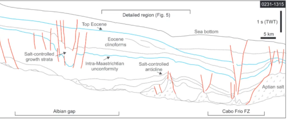
Figure 4 – Line drawing of a dip-oriented 2D seismic section highlighting the main post-rift structural features in
the study area.
we adopt the premise that the shelf-margin adjusts to RSL, so the vertical component of shelf-margin trajectory at the seismic scale (low vertical resolution) approaches RSL fluctuations.
RESULTS
Figure 4 is a dip-oriented seismic interpretation of the post-rift interval in northern Santos Basin (see location in Fig. 1), in which the area examined herein can be tied to the overall geological context and the influence of salt tectonics be observed. The study area lies between the Albian gap and the Cabo Frio fault zone. In the more proximal domain, the interval of interest (roughly delimited by blue horizons; Fig. 4) is affected by an extensional fault zone that promotes stratal rollover, tilting and the development of growth strata. In the more distal segment, underlying beds are deformed by a gentle anticline floored by a set of salt domes. This anticline seems to be also controlled by stratal rollover associated with the Cabo Frio fault zone located few kilometers basinward.
The studied interval is dominated by sets of high- to moderate-relief (up to 400 m-thick) prograding clinoforms with a well-defined topset-foreset-bottomset morphology (Fig. 5-A). The overall framework observed in Figure 4 strongly suggests that stratal tilting related to extensional faulting was the mechanism that created the initial slope from which clinoforms prograded. The topset domain of the clinoforms may be aggradational or degradational, the latter being recorded as erosive unconformities that extend throughout the topset profile and truncate upper foreset strata. These unconformities are often associated with deep incisions with reliefs up to 150 m filled with high-amplitude and laterally discontinuous reflectors or transparent units. Aggradational topsets form parallel to divergent, high- to moderate-amplitude reflector packages.
The lower foreset and bottomset domain commonly display high-amplitude reflections and chaotic units that onlap the inclined foresets. The chaotic units are most typically 50 to 200 m thick, they have lenticular to sigmoidal geometry and exhibit internal deformation (faults, folds and tilted strata). In some stratigraphic levels these units are clearly associated upslope with steep scars that truncate the basinward segment of aggradational topset deposits. The prograding clinoforms can be interpreted as a product of shelf-margin accretion because of their relief of up to hundreds of meters (e.g., Helland-Hansen & Hampson, 2009). The bottomset high-amplitude and chaotic facies likely correspond to deepwater sands and mass-transport deposits respectively (e.g., Posamentier & Martinsen, 2011). A total of 40 seismic horizons were mapped (Fig. 5-B) and their correspondent stratal terminations (onlap, downlap and truncation) recognized. Clinoform rollovers (i.e., paleo-shelf margins) were picked for each horizon whenever possible and assumed as proxies for former positions of RSL. These data were used to build a trajectory diagram (Fig. 5-C) and a chronostratigraphic chart from which a RSL curve was interpreted (Fig. 6).
Relative ages for mapped key surfaces and stratigraphic intervals were determined by correlation with previous stratigraphic schemes (e.g., Modica & Brush, 2004; Moreira et al., 2007). Recognized shelf-margin trajectories include 1) flat to descending regressive (forced regression), 2) ascending regressive (normal-regressive) and 3) transgressive. Forced-regressive trends dominate the stratigraphy whereas transgressive trends are scarce. Ten main unconformities and their correlative conformities (sequence boundaries; SB01 to SB10) are recognized, corresponding to changes from forced-to normal-regressive or transgressive trends and limiting sequences lasting for approximately 3,5 My each. Two of these
GARCIA AM, PIRES CA, MÜNCH D, CARVALHO IFP, FREITAS LS, VALORE LA, SILVA CE, LIMA RN, BALENSIEFER DF & VESELY FF
169
Figure 5 – Stratigraphic interpretations derived from the studied seismic section. A) Uninterpreted seismics. B) Line
drawing showing the main mapped horizons and seismic facies. C) Shelf-margin trajectory diagram based on 28 recognized topset-foreset rollovers.
boundaries (SB03 and SB08) are remarkable for their larger time amplitude and because they record the most significant basinward shifts of onlapping surfaces. They are interpreted as lower order sequence boundaries and divide the stratigraphy into three sequence sets (SS01: Campanian-Maastrichtian; SS02: Paleocene; SS03: Eocene to earliest Oligocene) containing three to four higher-order sequences.
The Campanian-Maastrichtian sequence set has the largest amount of topset aggradation, materialized as a relatively high average angle of the shelf-margin trajectory and a low progradation/aggradation ratio (P/A = 23). In contrast, the overlying sequence sets present a more prominent progradational pattern (Paleocene P/A = 65; Eocene P/A = 54) and low-angle to descending regressive trajectories are more common (Fig. 5-C).
Three main transgressive episodes (T01 to T03) are identified, which were responsible for shifting the shelf-margin several km landwards. In the distal end of the section, significant non-depositional hiatuses appear associated with the downlap terminations of clinoform packages. The hiatuses with the largest temporal amplitude and farthest landward expression occur in SS02 (Paleocene) and are associated with the longest verified period of high RSL (Fig. 6). All the four main mass-transport deposits recognized (chaotic units) are related to forced-regressive trajectories, indicating emplacement during RSL falls (Fig. 6). Deepwater sands (high-amplitude bottomsets), on the other hand, seem to occur associated with both normal-and forced-regressive clinoform packages, indicating deposition during both falls and rises in RSL. The origin of these deepwater
Figure 6 – Chronostratigraphic chart and RSL curve for the Late Cretaceous to Paleogene succession in northern Santos Basin. Tr, transgression; FR, forced regression;
NR, normal regression; MTD, mass-transport deposit.
sands is uncertain because it was not possible to observe their geometry in map view in our dataset. However, based on previous work, they probably include an association of turbidite fans and bottom-current-related deposits (Moreira & Carminatti, 2004; Duarte & Viana, 2007; Berton & Vesely, 2016).
DISCUSSION
Recently, the overall sequence-stratigraphic framework of the Santos Basin was discussed in three main publications (Modica & Brush, 2004; Moreira et al., 2007; Assine et al., 2008). These authors subdivided the basin into a number of depositional sequences bounded by regional unconformities that reflect drops in base level or sediment starvation conditions. Our examination of the shelf-margin trajectory based on a local, but high-quality, seismic survey provides a more detailed understanding of the stratigraphic evolution for the Late Cretaceous to Paleogene interval of the basin. By comparison with those previous papers, the examined interval encompasses sequences 5 to 8 of Modica & Brush (2004), sequences K120, K130 and E10 to E60 of Moreira et al. (2007) and sequences H7-H7.1 to H8-H8.2 according to Assine et al. (2008).
The sequence SB03 defined in this work is equivalent to the “intra-Maastrichtian unconformity” (Moreira et al., 2007), “sequence boundary 6” (Modica & Brush, 2004) and horizon H7.1 (Assine et al., 2008). This unconformity, dated as 68,8 Ma, is the base of a sedimentary package recording the maximum seaward displacement of the shelf-margin during the Cretaceous (Moreira et al., 2007), which coincide with the interval showing the highest P/A rates in our study. According to the model of Modica & Brush (2004), SB03 does not have a good correlation with a major eustatic fall. RSL fall at that time was thus probably driven by uplifting at the Serra do Mar region during the Late Cretaceous (e.g., Zalán & Oliveira, 2005) or, alternatively, a result of local sin-depositional deformation related to halokinesis.
The prominent landward shift of the shelf-margin observed close to the K/Pg boundary (T01) matches with a transgressive event indicated by Moreira et al. (2007), but does not seem to be related to any important eustatic peak. As our study is based on one single section in the northern part of the basin, this event is probable related to local (e.g., lowering sediment supply, salt induced subsidence) instead of global drivers.
GARCIA AM, PIRES CA, MÜNCH D, CARVALHO IFP, FREITAS LS, VALORE LA, SILVA CE, LIMA RN, BALENSIEFER DF & VESELY FF
171
In contrast with the stratigraphic chart of Moreira et al. (2007), our chronostratigraphic diagram (Fig. 6) highlights the presence of important non-depositional hiatuses in the distal part of the basin. These times of very low sedimentation rates in the basin are more pronounced during SS02 (Paleocene), which correspond to a period of eustatic highstand (Modica & Brush, 2004) and encompasses two of the three transgressive episodes observed in the study area. The detection of these underreported time intervals of sediment starvation may have implications for the location of organic-rich layers (condensed sections) with petroleum source rock potential.
Concerning the occurrence of mass-transport deposits, our analysis corroborates the results obtained by Berton & Vesely (2016) in the Eocene, who linked submarine landslides to RSL falls. This correlation is also clear in the Late Cretaceous succession (SS01), in which a huge mass-transport deposit (Maricá slump; Carlotto & Rodrigues, 2009) is genetically linked to an irregular surface that deeply incises the outer shelf and upper slope (SB02 in the present paper). Concerning eustatic sea level, the whole studied interval is placed during a long-term sea level fall (Modica & Brush, 2004). This may explain why there is a general decrease in the amount of estimated topset aggradation (SS01 = 620 m; SS02 = 200 m; SS03 = 120 m), which is probable a result of progressively lower accommodation rates at the shelf from the Late Cretaceous to the Eocene. Higher-frequency cyclicity, however, does not fit well with eustatic sea level changes and seems to be related to local factors such as tectonics, changes in sediment supply and sedimentation rates and halokinesis.
Late Cretaceous to Eocene deepwater sands were previously indicated as important exploratory plays in northern Santos Basin (Chang et al., 2008). High-amplitude reflectors corresponding to these deposits occur at the bottomsets of clinoforms with both normal- and forced-regressive trajectories (se also Berton & Vesely, 2016) and seems to be unpredictable using sequence stratigraphy. However, those deepwater sands that are genetically related to base level drops are more often placed below and/or above mass-transport deposits. This may be prejudicial to seal effectiveness once these mass-transport deposits, which are chaotic, admixtures of fine and coarse-grained sediment (e.g., Carlotto & Rodrigues, 2009), tend to be less argillaceous than pelagic/hemipelagic muds.
CONCLUSIONS
From the interpretation of a high-quality dip-oriented seismic section, it was possible to expand the knowledge about the
stratigraphic framework of the post-rift succession in northern Santos Basin:
• The studied interval comprises Campanian-Maastrichtian, Paleocene and Eocene to earliest Oligocene sequence sets. Each of those contains three to four higher-order sequences lasting approximately 3,5 My. Most of these higher-order sequences include forced-regressive and normal-regressive shelf-margin trajectories associated with long-term RSL falls and relatively high sediment supply from the uplifted Serra do Mar region. Only three expressive transgressive episodes were identified, two of them during the Paleocene, which correlates to a period of higher eustatic sea level;
• The emplacement of voluminous mass-transport deposits triggered by clinoform instability in both the Cretaceous and Paleogene sequences can be associated with relative sea level falls observed as descending shelf-margin trajectories;
• Significant unreported non-depositional hiatuses were identified in the distal termination of shelf-margin clinoforms, which, because of sediment starvation conditions may be important to the generation of organic-rich layers with petroleum source rock potential. This a major difference between our results and previous stratigraphic interpretations for the Santos Basin.
ACKNOWLEDGMENTS
This work was conducted during a sequence stratigraphy class of the Postgraduate Program in Geology at UFPR. The authors thank Agência Nacional do Petróleo, Gás Natural e Biocombustíveis (ANP) for seismic data. Coordenação de Aperfeiçoamento de Pessoal de Nível Superior (CAPES) is thanked for providing scholarships to A.M.G. and C.E.S. F.F.V. thanks Conselho Nacional de Desenvolvimento Científico e Tecnológico (CNPq) for financial support (grants 461650/2014–2 and 302842/2017-9). The authors also thank Webster Mohriak for helpful suggestions that improved the quality of the manuscript.
REFERENCES
ASSINE ML, CORRÊA FS & CHANG HK. 2008. Migração de depocentros na Bacia de Santos: importância na exploração de hidrocarbonetos. Revista Brasileira de Geociências, 38: 111–127. doi: 10.25249/0375-7536.2008382S111127.
BERTON F & VESELY F. 2016. Stratigraphic evolution of Eocene clinoforms from northern Santos Basin, offshore Brazil: Evaluating controlling factors on shelf-margin growth and deep-water sedimentation. Marine and Petroleum Geology, 78: 356–372. doi: 10.1016/j.marpetgeo.2016.09.007.
BUCKLEY JP, BOSENCE D & ELDERS C. 2015. Tectonic setting and stratigraphic architecture of an Early Cretaceous lacustrine carbonate platform, Sugar Loaf High, Santos Basin, Brazil. Geological Society, London, Special Publications, 418: 175–191. doi: 10.1144/SP418.13. CARLOTTO M & RODRIGUES L. 2009. The Maricá Slump - Anatomy of a Maastrichtian gravity mass flow deposit, Santos Basin. Boletim de Geociencias da Petrobras, 18: 51–67.
CARVAJAL CR & STEEL RJ. 2006. Thick turbidite successions from supply-dominated shelves during sea-level highstand. Geology, 34(8): 665–668. doi: 10.1130/G22505.1.
CATUNEANU O. 2006. Principles of Sequence Stratigraphy. Boston: Elsevier. 375 pp.
CATUNEANU O, GALLOWAY WE, KENDALL CGSC, MIALL AD, POSAMENTIER HW, STRASSER A & TUCKER ME. 2011. Sequence stratigraphy: methodology and nomenclature. Newsletters on Stratigraphy, 44(3): 173–245.
CHANG HK, ASSINE ML, CORRÊA FS, TINEN JS, VIDAL AC & KOIKE L. 2008. Sistemas petrolíferos e modelos de acumulação de hidrocarbonetos na Bacia de Santos. Revista Brasileira de Geociências, 38(2 suppl): 29–46.
DUARTE CSL & VIANA AR. 2007. Santos Drift System: stratigraphic organization and implications for late Cenozoic palaeocirculation in the Santos Basin, SW Atlantic Ocean. Geological Society, London, Special Publications, 276(1): 171–198.
FERNANDEZ RO & SANTOS AJ. 2017. Bacia de Santos: Sumário Geológico e Setores em Oferta. Superintendência de Definição de Blocos. 14aRodada de Licitações da ANP, Brazil.
HELLAND-HANSEN W & HAMPSON G. 2009. Trajectory analysis: concepts and applications. Basin Research, 21(5): 454–483.
HENRIKSEN S, HAMPSON GJ, HELLAND-HANSEN W, JOHANNESSEN EP & STEEL RJ. 2009. Shelf edge and shoreline trajectories, a dynamic approach to stratigraphic analysis. Basin Research, 21(5): 445–453. JACKSON CAL. 2011. Three-dimensional seismic analysis of megaclast deformation within a mass transport deposit; implications for debris flow kinematics. Geology, 39(3): 203–206.
JACKSON CAL, JACKSON MPA & HUDEC MR. 2015. Understanding the kinematics of salt-bearing passive margins: A critical test of competing hypotheses for the origin of the Albian Gap, Santos Basin, offshore Brazil. GSA Bulletin, 127(11-12): 1730–1751.
JOHANNESSEN EP & STEEL RJ. 2005. Shelf-margin clinoforms and prediction of deepwater sands. Basin Research, 17(4): 521–550. KARNER GD & GAMBOA LAP. 2007. Timing and origin of the South Atlantic pre-salt sag basins and their capping evaporites. Geological Society, London, Special Publications, 285(1): 15–35.
MACEDO JM. 1989. Evolução tectônica da Bacia de Santos e áreas continentais adjacentes. Boletim de Geociências da Petrobras, 3: 159–173.
MODICA CJ & BRUSH ER. 2004. Postrift sequence stratigraphy, paleogeography, and fill history of the deep-water Santos Basin, offshore southeast Brazil. AAPG Bulletin, 88(7): 923–945.
MOHRIAK W. 2003. Bacias sedimentares da margem continental brasileira. In: BIZZI LA, SCHOBBENHAUS C, VIDOTTI RM & GONÇALVES JH (Eds.). Geologia, Tectônica e Recursos Minerais do Brasil. CPRM, Brazil. p. 87–165.
MOHRIAK W. 2014. Birth and development of continental margin basins: Analogies from the South Atlantic, North Atlantic, and the Red Sea. AAPG Search and Discovery Article #41502.
MOHRIAK WU, MACEDO JM, CASTELLANI RT, RANGEL HD, BARROS AZN, LATGÉ MAL, RICCI JA, MIZUSAKI AMP, SZATMARI P, DEMERCIAN LS, RIZZO JG & AIRES JR. 1995. Salt tectonics and structural styles in the deep-water province of the Cabo Frio region, Rio de Janeiro, Brazil. American Association of Petroleum Geologists Memoir, 65: 273–304. MOREIRA J & CARMINATTI M. 2004. Eocene slope and basin depositional systems in the Santos Basin. Boletim de Geociências da Petrobras, 12: 73–87.
MOREIRA J, CV M, GIL J & MACHADO M. 2007. Bacia de Santos. Boletim de Geociências da Petrobras, 15: 531–549.
PEREIRA M, BARBOSA C, AGRA J, GOMES J, ARANHA L, SAITO M & BAGNI O. 1986. Estratigrafia da Bacia de Santos: análise das sequências, sistemas deposicionais e revisão litoestratigráfica. In: 34 Congresso Brasileiro de Geologia. Anais, Goiânia, Brazil, p. 65–79.
PEREIRA M & MACEDO J. 1990. A Bacia de Santos: perspectivas de uma nova província petrolífera na plataforma continental sudeste brasileira. Boletim de Geociências da Petrobras, 4: 3–11.
PEREIRA MJ & FEIJÓ FJ. 1994. Bacia de Santos. Boletim de Geociências da Petrobras, 8: 219–234.
POSAMENTIER HW, JERVEY MT & VAIL PR. 1988. Eustatic controls on clastic deposition I – conceptual framework. SEPM Special Publication, 42: 109–124. doi: 10.2110/pec.88.01.0109.
POSAMENTIER HW & MARTINSEN OJ. 2011. The character and genesis of submarine mass-transport deposits: insights from outcrop and 3D seismic data. In: SHIPP RC, WEIMER P & POSAMENTIER HW (Eds.). Mass-transport deposits in deepwater settings. Volume 96, p. 7–38. Tulsa: SEPM Special Publication. doi: 10.2110/sepmsp.096.007.
GARCIA AM, PIRES CA, MÜNCH D, CARVALHO IFP, FREITAS LS, VALORE LA, SILVA CE, LIMA RN, BALENSIEFER DF & VESELY FF
173
QUIRK DG, SCHØDT N, LASSEN B, INGS SJ, HSU D, HIRSCH KK & VON NICOLAI C. 2012. Salt tectonics on passive margins: examples from Santos, Campos and Kwanza basins. Geological Society, London, Special Publications, 363(1): 207–244.
SOMBRA CL, ARIENTI LM, PEREIRA MJ & MACEDO JM. 1990. Parâmetros controladores da porosidade e da permeabilidade nos reservatórios clásticos profundos do Campo de Merluza, Bacia de Santos, Brasil. Boletim de Geociências da Petrobras, 4(4): 451–466.
VAIL PR, MITCHUM Jr RM & THOMPSON S. 1977. Seismic stratigraphy and global changes of sea level: Part 3. Relative changes of sea level from Coastal Onlap: Section 2. Application of seismic reflection Configuration to Stratigraphic Interpretation. AAPG Special Volumes, 26: 63–81.
ZALÁN PV & OLIVEIRA JAB. 2005. Origem e evolução estrutural do Sistema de Riftes Cenozóicos do Sudeste do Brasil. Boletim de Geociências da Petrobras, 13(2): 269–300.
Recebido em 30 novembro 2018 / Aceito em 6 maio 2019 Received on November 30, 2018 / Accepted on May 6, 2019