Int. J. Advanced Networking and Applications
Volume: 07 Issue: 03 Pages: 2752-2755 (2015) ISSN: 0975-0290
2752
Disseminating Traffic Information in Vehicular
Networks
Muhammad Alyas Shahid
Department of Computer Science, COMSATS Institute of Information Technology, Wah Cantt Email : [email protected]
Aisha Azeem
Department of Computer Science, COMSATS Institute of Information Technology, Wah Cantt Email : [email protected]
---ABSTRACT--- In this paper Wifi based system is described for disseminating traffic information in vehicular networks. Basic aim of this approach is to distribute information regarding the traffic conditions such as traffic congestions or safety warnings to vehicles in an effective way.
Key Words: Disseminating Traffic Information in Vehicular Networks, Base station, Mobile Node, WiFi, Wireless Sensor Networks.
--- Date of Submission: Oct 05, 2015 Date of Acceptance: Nov 16, 2015
---
---I. Introduction
W
ith the passage of time, as the technology is advancing, more and more new systems and applications are being developed to provide ease to the life of human beings. One of these advancements is, making an intelligent vehicles system that will be used by everyone in the near future.Vehicular ad hoc network is the name suggested for this ad hoc network in which vehicles equipped with a VANET device, which acts as a node in the ad hoc network. Communication is possible among the vehicles because of this wireless technology [1]. Only those vehicles can communicate in peer-to-peer manner that lie in communication range.
When a number of such vehicles come into the range of that radio system, they form a cluster which unite and collapse as the vehicles come and by pass. Another property of this network is that the vehicles can communicate with the fixed infrastructure like access points/gateways along the roadsides.
In this field, the research is in progress as more and more traffic congestion problems are becoming which can be seen in major cities of the world. Most of the time the traffic is blocked due to bad climatic conditions, accidents or by disabled vehicles, what so ever is the cause they become the source of congestion of busy roads [2].
Although a number of systems are working to monitor the traffic conditions e.g. Etak Traffic [3] but major weakness of that systems are required a heavy cost of deployment in order to cover all the road networks. This cost may include sensor devices, cameras etc. Still other systems require specialized devices [4] embedded on the Communication board for disseminating traffic information named Traffic Rep. It is a device constructed from three components i.e. a static digital road map, Wifi as a wireless link and GPS devices to obtain the correct position of the vehicle. Other systems
involve a centralized approach instead of specialized devices. Such systems require loop detecting sensors and cameras that pass sensed information to centralized authority but this approach is based on a slow and expensive system.
In [5] navigation system or Travelpiolet [6-8] which is described, provides function to driver like to finding shortest path, in order to save time but is faced with some major limitations.
Based on these previous approaches and literature survey a new WiFi based system is presented that does not require too much cost. Further more with IEEE 802.11, 40MB of data can be transferred between access points even if the vehicles are moving at a speed of 60mphs [9].
It also overcomes the limitations of those systems that use GPS based systems for monitoring vehicles. The major limitation of such systems is that GPS can’t locate vehicles inside tunnels or airports. The approach presented below tries to overcome these weaknesses. For the security of Disseminating Traffic Information in Vehicular Networks, a Wireless USB Security System by using Internet Technology can be used [10] with a surveillance system Using Wireless Sensor Networks (WSN) [11] while for the measurement of distances, a Laser Guided Real Time Object Measurement and Distance Calculation System can also be used to achieve really good results. [12]
Int. J. Advanced Networking and Applications
Volume: 07 Issue: 03 Pages: 2752-2755 (2015) ISSN: 0975-0290
2753
II.
Proposed Technique
In order to overcome the limitations encountered in that systems, [4] a new approach for disseminating traffic information is proposed.
The proposed system consists of following components:
Base Station (BS), that act as central server for each zone
Mobile Nodes, in this case which are vehicles,
WiFi Access Points.
Basic assumptions of the system are:
All WiFi Access Points of a particular Zone lie within the radio range and hence can communicate with each other. Each access point has a unique ID relevant to that zone.
It is also assumed that each Zone has a Base Station, which is linked to the Access Points via wired network.
Fig 1 - Basic Architecture of the System
Another important point is that Base Station also has a wired link as a backbone connection to the main server. Each Zone follows the above mentioned structure, which is arranged in a Hexagonal form as shown in figure -1.
WiFi Access Points are deployed at various locations along roadsides. When a number of vehicles come under the range of an Access Point it forms a cluster of vehicles. The vehicles within this cluster can communicate in Peer-to-Peer manner and exchange data packets.
If a particular vehicle already contains that data packet, it will be discarded otherwise it stores that packet for processing and propagates it to other vehicles.
An additional property of the system is that a complete summary of traffic information is stored at the Main Server for analysis purposes. As mentioned earlier Main Server has a wired link to Base Station of each Zone.
A snap shot of a particular zone is shown below in figure 2. If in future, information regarding a particular Zone is required, it can be retrieved through this summary. This summary information contains safety warnings or traffic congestion encountered in particular Zone. In this way traffic information can be monitored.
Fig 2 - Complete Model of the System Showing Clusters of Vehicles under the Range of Fixed Access Points
a) Querying to a Mobile Node
The proposed approach also allows a vehicle to query to an access point that lies in its range to find out about the traffic conditions ahead where this vehicle intends to go.
Each Node maintains a Data Table that contains all the data regarding queries and request types. It stores those queries, which are recently received from other vehicles. Upon receiving the query from a particular node, following process is executed as shown in figure 3, in which main steps are described below:
Int. J. Advanced Networking and Applications
Volume: 07 Issue: 03 Pages: 2752-2755 (2015) ISSN: 0975-0290
2754
First, Node checks to see that if same request had already catered for.
If true, then this step is ignored and message is prompted, that redundant request.
If not, store the query in the Data Table for processing depending upon its time stamp and request type.
If the node has the intended data, it will send it back on the same ID.
Otherwise, if node does not have the relevant data, it sends request to the nearest Access Point, and retrieves relevant data from Base Station.
b) Example
Suppose a particular vehicle puts forward a query to Access Point with ID AP1 and intends to know the traffic conditions at the surroundings of AP3, which is at distance from AP1.
AP3 broadcasts this request to the vehicles located in its vicinity.
Each node then searches its Data Table to check if this query is new or old depending upon the time stamp and who initiated the request by determining the ID. Table 1 shows the required information.
Table.1 - Sample Data Table Displaying Required Information of a Particular Vehicular Node.
If the query is new and its time stamp is high, node sends the required data packets back to the Access Point i.e. in this case AP3.
Upon receiving the data, it delivers the intended data to the previous Access Point so that it can fulfill its requirements and send it to its Destination Node. Figure 4 shows a snapshot of the scenario.
Figure 5 shows this scenario whose entry is shown in Table-1.
Fig 4 - Snapshot of Communicating Nodes
If no vehicle is currently present in the Access, Points range it sends request to the nearest Base Station to
supply the relevant data. If for some reason it does not contain any information then request is sent to Central Server, which always contains an updated data from Base Station via Access Points.
After obtaining the required information, it delivers summary of traffic conditions obtained from the Central Server, to the Access Point. In this way, vehicles bring about communication and know about the traffic conditions.
If there is any traffic jam, near a particular Access Point then in this case broadcast is made to all the in coming vehicles to change their route and server also notes its performance for future references.
The Data Table might look like the one described in table 1 which indicates the relevant data e.g. traffic warnings, traffic congestions or accidents etc. There is also a column in table representing the source ID’s, which shows which Node initiated the request.
Fig 5- Internal Details of the Communication Process
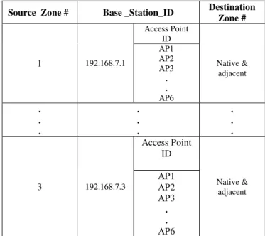
The Main Server provides the required information to Base Stations so that the nodes can update their Data Table and have the latest updates about road conditions. Table 2 shows the routing information of particular zone, ID associated with its Base Station and the relevant Access Points. One thing to mention here is that each Base Station can broadcast the message to its native Access Points and the one’s to its adjacent zone.
Table 2- Routing Table showing Source to Destination Routing of Information
Source_ID Data Prev_Hop T_stamp
V1 Traffic
Congestion AP2 T1
V3 Accident AP1 T3
Source Zone # Base _Station_ID Destination
Zone #
1 192.168.7.1
Access Point ID
Native & adjacent AP1
AP2 AP3
. .
AP6 .
. .
. . .
. . .
3 192.168.7.3
Access Point ID
Native & adjacent
AP1 AP2 AP3
. .
Int. J. Advanced Networking and Applications
Volume: 07 Issue: 03 Pages: 2752-2755 (2015) ISSN: 0975-0290
2755
III.
Conclusion
In this paper, a new approach for disseminating traffic information in vehicular networks by using WiFi as wireless technology is presented and described. WiFi has added advantages over GPS based systems, which is described in previous work by many authors. The feature that makes the system unique is its data disseminating methodology that is described in this paper. It is this characteristic, which helps in delivering the traffic information in an effective way, which was the ultimate goal of this paper.
REFERENCES
[1]
U. Varsheney, Vehicular mobile commerce,IEEE Computer magazine online, December 2004
[2]
Traffic congestion and sprawl. Federalhighway administration, US department of transportation
[3]
EtakTraffic-real time traffic information[4]
Smair Goel, Tomasz Imielinski, KaanOzbay, ”Ascertaining viability of wifi based
vehicle-to- vehicle network for traffic
Information”
[5]
Briesemeister and Hommel, “Role –basedmulticast in highly mobile but sparsely
connected ad hoc networks”.
[6]
Neukirchner, Ernst-Peter, Ralf Kriesinger, andJürgen Wazeck. "Navigation systems." In Brakes, Brake Control and Driver Assistance Systems, pp. 246-253. Springer Fachmedien Wiesbaden, 2014.
[7]
Enkelmann, W., V. Gengenbach, W. Krüger,H. H. Nagel, and G. Nirschl. "EVALUATION OF IMAGE SEQUENCES." Advances in Automotive Control 1995 (2014): 215.
[8]
Bussmann, Alexander, Joseph Figueroa, andThomas G.Phillips. "Location based services with combinatorial data sources." U.S. Patent 8,798,916, issued August 5, 2014
[9]
R.Gedge.802.11 wireless LAN at speed,Internal Report
[10]
Jamal Hussain Shah, Muhammad Sharif,Mudassar Raza, Saeed-Ur-Rehman, “ Wireless USB Home Security System using
Internet Technology”, Research Journal of
Applied Sciences, Engineering and Technology, Vol. 7,No. 7, 2014
[11]
B. A. Khan, M. Sharif, M. Raza, T. Umer,K.Hussain, and A. U. Khan, " An Approach for Surveillance Using Wireless Sensor Networks (WSN)," Journal of Information & Communication Technology, Vol. 1, pp. 35-42, 2007.
[12]
Muhammd Sharif, M. Hassan, M. H. Khan,M. Raza, A. U. Khan, “Laser Guided Real
Time Object Measurement and Distance
Calculation System”, Sindh Univ. Res. Jour.
(Sci. Ser.) Vol.45 (3) 467-476 (2013).
Biographies and Photographs
Muhammad Alyas Shahid received his
Master in Computer Science from Alkahir University, Islamabad. He is studying his MS(CS) from COMSATS, Wah Cantt with specialization in Image Processing. He is into teaching field from 1998 till date. Currently he is working as Head of Department Computer Section in POF Institute of Technology, Wah Cantt. His research interests are Image Processing, Computer Networks & Security, Database and Computer Languages.