i
THE WEB FEATURE SERVICE –
TRANSACTION STANDARD
Jacinto Paulo Simões Estima
ii
THE WEB FEATURE SERVICE – TRANSACTION STANDARD
An example of prototype implementation
Project Work supervised by
Professor Doutor Pedro da Costa Brito Cabral
iii
ACKNOWLEDGMENTS
I begin by thanking to my supervisor Professor Pedro Cabral, for his patience, suggestions and guidance, and to whom I express my sincere gratitude.
Sincere thanks to my friends and colleagues António José Silva and Hugo Martins for the suggestions and support given.
A special thanks to my friend Joana Simões, for all the precious help given in programming the developed application. Thanks Joana.
Big thanks to my colleague and friend Ana Balula for the suggestions made regarding language issues.
Last but not least, to my wife Ana Cristina Estima, my son João Pedro Estima and my parents for their support and understanding during the whole process.
iv
THE WEB FEATURE SERVICE – TRANSACTION STANDARD
An example of prototype implementation
RESUMO
v
THE WEB FEATURE SERVICE – TRANSACTION STANDARD
An example of prototype implementation
ABSTRACT
vi
PALAVRAS-CHAVE
Interoperabilidade
Sistemas de Informação Geográfica Serviços Web
Standards OGC Web Feature Service
Web Feature Service - Transaction Web Map Service
KEYWORDS
Interoperability
Geographic Information Systems Web Services
OGC Standards Web Feature Service
vii
ACRONYMS
API – Application Programming Interface
BBOX – Bounding Box
CRS – Coordinate Reference System
DB – Database
EPSG – European Petroleum Survey Group
EU – European Union
EXE – Filename extension denoting an executable file
FAQ – Frequently Asked Questions
GI – Geographic Information
GIS – Geographic Information Systems
GML – Geography Markup Language
HTML – HyperText Markup Language
HTTP – HyperText Transfer Protocol
HTTPS – Hypertext Transfer Protocol Secure
IGP – Instituto Geográfico Português (Portuguese Geographic Institute)
IT – Information Technologies
JDK – Java Development Kit
KVP – Keyword-Value Pairs
viii
OGP – International Association of Oil & Gas Producers
OS – Operating System
SDI – Spatial Data Infrastructure
SNIG – Sistema Nacional de Informação Geográfica (National System of Geographic Information)
SOAP – Simple Object Access Protocol
SRS – Spatial Reference System
UDDI – Universal Description, Discovery and Integration
URL – Uniform Resource Locator
XML – Extensible Markup Language
XPath – XML Path
W3C – World Wide Web Consortium
WFS – Web Feature Service
WFS-T – Web Feature Service Transactional
WMS – Web Map Service
WS – Web Service
WSDL – Web Service Definition Language
ix
TABLE OF CONTENTS
ACKNOWLEDGMENTS ... iii
RESUMO ... iv
ABSTRACT ... v
PALAVRAS-CHAVE ... vi
KEYWORDS ... vi
ACRONYMS ... vii
TABLE OF CONTENTS ... ix
LIST OF TABLES ... xii
LIST OF FIGURES ... xiii
1. Introduction ... 1
1.1. GIS: From Desktop to Internet ... 1
1.2. Dissertation scope ... 1
1.3. Objectives and hypothesis ... 4
1.4. Structure of the dissertation ... 5
2. GI Thru the Internet ... 6
2.1. Introduction ... 6
2.2. Overview ... 6
2.3. Interoperability and OGC ... 6
2.4. Web Services ... 7
2.4.1. Web Map Service ... 10
2.4.2. Web Feature Service ... 14
x
2.5. Conclusions ... 26
3. Framework definition ... 28
3.1. Introduction ... 28
3.2. System Architecture ... 28
3.3. Available Software ... 29
3.3.1. Data section ... 29
3.3.2. Server section ... 30
3.3.2.1. WFS-T Server ... 30
3.3.2.2. Web Server ... 31
3.3.2.3. Web Tools ... 31
3.3.3. Client section ... 32
3.3.3.1. Desktop Applications ... 32
3.4. Selected software ... 33
3.5. FOSS vs. Proprietary Software ... 35
3.6. Conclusions ... 36
4. Prototype implementation ... 37
4.1. Introduction ... 37
4.2. Software download and installation ... 37
4.2.1. XAMPP ... 38
4.2.2. PostgreSQL/PostGIS ... 38
4.2.3. GeoServer ... 38
4.2.4. MapFish ... 38
4.2.5. UDig ... 39
xi
4.3.1. Database preparation ... 39
4.3.2. GeoServer preparation ... 40
4.3.3. uDig preparation ... 41
4.3.4. Web client application development ... 43
4.4. Conclusions ... 58
5. Conclusions ... 60
5.1. The developed WFS-T-compliant FOSS prototype: advantages and limitations... 60
5.2. Main conclusions ... 60
5.3. Future work ... 61
xii
LIST OF TABLES
Table 1 - Interrogation process of the GetCapabilities operation ... 11
Table 2 - Service element of the GetCapabilities operation answer ... 11
Table 3 - Capabilities element of the GetCapabilities operation answer ... 12
Table 4 - GetMap operation attributes... 13
Table 5 - GetFeatureInfo attributes ... 14
Table 6 - General OGC Web Service request ... 16
Table 7 - Operation Request Encoding ... 17
Table 8 - Values for resultType attribute ... 21
Table 9 – Some attributes of the GetFeature operation ... 21
Table 10 - lookAction operation values ... 23
Table 11 - Optional elements of a LockFeature operation ... 24
Table 12 - Values of the attribute idgen ... 25
Table 13 - Description of some elements of a Transaction operation response ... 25
Table 14 - Chosen software for the prototype implementation ... 34
xiii
LIST OF FIGURES
Figure 1- Evolution of GIS (adapted from Peng and Tsou (2003)) ... 2
Figure 2 - Web services framework (Source: Whiteside (2005)) ... 8
Figure 3 - Communication protocols (adapted from Kreger (2001) ... 10
Figure 4 - State diagram for a WFS lock (Source: Vretanos (2005)) ... 23
Figure 5 - System architecture ... 29
Figure 6 - System architecture with selected software ... 35
Figure 7 - Add data form ... 41
Figure 8 - URL of wfs GeoServer ... 42
Figure 9 - WFS layer on a uDig map ... 42
Figure 10 - Editing WFS layer on uDig map ... 43
Figure 11 - Layout ... 44
Figure 12 - Application toolbar ... 51
Figure 13 - Final layout of the developed Web application ... 56
Figure 14 - Final layout when a dump is added ... 57
Figure 15 - Final layout when button "information" is selected and a mouse over occurs over a dump ... 57
Figure 16 - Final layout when editing a dump ... 58
1
1.
Introduction
1.1. GIS: From Desktop to Internet
The World Wide Web (WWW) has evolved significantly in the last years, especially at the technological level. The number of users has grown exponentially and, today, almost every family of developed and developing countries has an Internet connection. Consequently, a considerable amount of information emerges from the most varied sources. Most of this information has geographic representation and the WWW could be a very important exchange and/or dissemination vehicle. This is called Internet GIS, and represents an important advancement over the traditional desktop GIS (Peng and Tsou, 2003).
1.2. Dissertation scope
home and uses the WWW un-interoperable to distri In GI we have also assiste the computer technolo distributed GIS that inclu engines have now GIS o 2007).
Figure 1- Ev
With the Internet techn everyone, facilitating data One of the main proble format, inhibiting, for ex locations (Furtado, 2006 standards and specificati to operate together (Paul With this problem in con in 1994. The OGC is agencies and universities available interface specif
Mainframe GIS • • Desktop GIS • • Distributed GIS • 2
WW for this purpose, changing from closed, p istributed, open and interoperable applications. sisted to a change in paradigm, very close to th nologies, from mainframe GIS to desktop G ncludes mobile and Internet GIS (figure 1). All th
IS offerings, like Google maps geocoding capa
Evolution of GIS (adapted from Peng and Tsou (2003))
echnology, GIS concepts are more open and data access and exchange (Dragicevic, 2004). oblems in this evolution is the data, normally
r example, the use of data from different serve 006). This problem is solved through the de ications that make it possible for devices, data,
Paul A. Longley, 2005).
concern, the Open Geospatial Consortium (OG is an international consortium of companies ities participating in a consensus process to de ecifications. OpenGIS Specifications (technical d
•GIS programs hosted in a mainframe •Terminal access
•Stand-alone programs with no information exchange •networked programs sharing data or applications
within Local-Area Networks (LANs)
•GIS programs working on the Internet (Internet GIS or wireless network environments (Mobile GIS)
d, proprietary and ons.
to the evolution of p GIS to recent ll the major search capabilities (Davis,
3))
and accessible to
ally in proprietary ervers at different e development of ata, and processes
(OGC) was created nies, government o develop publicly al documents that
3
detail interfaces or encodings) support interoperable solutions that "geo-enable" the Web, wireless and location-based services, and mainstream Information Technologies (IT). The specifications empower technology developers to make complex spatial information and services accessible and useful with all kinds of applications (OGC, 2008).
The OGC has developed two important Open Standards - the Web Map Service (WMS) and the Web Feature Service (WFS), among many others. These two standards define the interfaces to remotely share and access GI. The WMS standard was first developed and offers a simple way to visualize GI, sending the “requested map” to the user as a static image while the WFS, with more functionalities, sends the features themselves with manipulation capabilities. Compliance with Open Standards is very important to warrant that different and remote systems share spatial data (Moreno-Sanchez, 2007).
Beyond these standards, it is also important to have some rules and policies to solve problems related to fragmentation of datasets and sources, gaps in availability, lack of harmonization between datasets at different geographical scales or duplication of information collection. The solution is to define Spatial Data Infrastructures (SDI). The European Union (EU), with this in mind, has created, in 2001, the initiative INSPIRE initiative1. The initiative intends to trigger the creation of a European spatial information infrastructure that delivers to the users integrated spatial information services. These services should allow the users to identify and access spatial or geographical information from a wide range of sources, from the local level to the global level, in an inter-operable way for a variety of uses (INSPIRE, 2009). To establish the general rules to achieve these objectives, the initiative has created the Directive with the same name that entered into force in May 2007.
This Directive should be based on the infrastructures for spatial information that are created by the Member States and that are made compatible with common
4
Implementing Rules and are supplemented with measures at Community level to ensure the compatibility and usability in a Community and transboundary context (INSPIRE, 2009).
In Portugal, the organization that leads this implementation is the Portuguese Geographic Institute (IGP), the national authority for the geographic information, and involves the National System of Geographic Information (SNIG) institutions. Henriques et al (1999) cited by Furtado (2006) states that SNIG was the first National Infrastructure of Geographic Information created in Europe, and also the first one in the world opened to the Internet, in 1995.
The IGP currently provides some GI through WMS and WFS specifications, like the “Atlas de Portugal” in WMS or the “Carta Administrativa Oficial de Portugal” both in WMS and WFS.
The Web Feature Service – Transaction (WFS-T) standard is one of the most recent specifications produced by the OGC and with enormous possibilities to be strongly used on the future, due to the benefit of editing features remotely through open standards. This is a very strong reason to study it and to make an implementation test.
1.3. Objectives and hypothesis
The main goal is to study the WFS-T standard. This includes the requirements verification to implement this specification and understand the transaction operation and how it can be implemented.
Further goals are to develop a prototype that implements the WFS with the transaction operation and to use both Open Source and proprietary software, to provide and access GI.
5
1.4. Structure of the dissertation
This dissertation is organised in 5 chapters. It begins with an introductory chapter that describes the scope, objectives and structure of the thesis.
The second chapter focuses on the GI through the Internet. The interoperability problem, the OGC and its Web Services (WMS and WFS) are addressed. The Geography Markup Language (GML) and the transaction operation of the WFS are also covered.
In the third chapter, emerges the framework definition for the prototype implementation. In this chapter, the system architecture and requirements are discussed. The results of some software tests are also presented. These tests aim at verifying which software is prepared to deal with the WFS standard.
6
2.
GI Thru the Internet
2.1. Introduction
In this chapter, an overview of the GI thru the internet, the interoperability as well as the OGC, the WMS, the Web Feature Service and the WFS-T are presented.
2.2. Overview
Internet GIS has been the most rapidly developing field in the geospatial technology industry (Peng and Zhang, 2004).
GI uses today the WWW to disseminate its content. There are, at the moment, many servers around the world providing spatial information to several users, and these accesses this information through different GIS applications also. Consequently, a problem arises: compatibility between different applications. This chapter introduces the interoperability problem, the OGC and some of the most important Web Services (WS) – The WMS and the WFS, the Geography Markup Language (GML) and the WFS-Transaction.
2.3. Interoperability and OGC
7
To deal with heterogeneous and distributed data, the applications must be able to locate, access, interpret and process the retrieved data, and the solution is not easy to achieve. There are lots of incompatibilities in data formats, software products, spatial conceptions, quality standards and models of the world (Vckovsky, 1998). This problem is known as the interoperability problem.
Interoperability refers in general to the ability of various autonomous systems to bring together parts and to operate in collaboration. In most cases this means the exchange of meaningful information (Vckovski, 1998).
According to Hecht referred by Geoffrey and Rafael (2003), there are some reasons that make interoperability desirable:
• Communication between information providers and final users without requiring that both have the same software;
• Combine accurate and up-to-date data from multiple sources opens new possibilities for improved decision making and it also makes data more valuable;
• The possibility of having multiple users, including non-GIS experts, using a particular set of data also makes the data more valuable.
For Limp referred by Peng and Zhang (2004), the OGC Web Service specifications offer a standard way for users to search for maps and geoprocessing sources over the Web from different map servers and different vendors, solving thus the interoperability problem.
2.4. Web Services
8
Beyond these, another great advantage of using Web services is related with data that is constantly changing. If a user downloads that data, it rapidly becomes out-of-date. But if he accesses data using Web services, he will have the warranty that he has the data updated and in real-time (Tyler, 2005).
The Web services framework is based on three elements: the server, the client and the catalogue, as shown in figure 2.
Figure 2 - Web services framework (Source: Whiteside (2005))
The server provides the service over the network. Its capabilities and localization are stored in the catalogue and the client is the user and/or application that uses the service.
In order to use this architecture, three important activities must take place: publish, search and interact. In detail, these activities are (Kreger, 2001):
a) Publish – a service description must be published in the catalogue so that can be searched by the client or requester.
b) Search – before using a service, the client must search a service description in the catalogue.
c) Interact – at this stage, the client interacts with the service at runtime, using their description obtained in the Search stage.
9
almost all internet applications, and XML (eXtensible Markup Language) which it is a standard defined by W3C2 used to represent data. These are the basics to communicate over the Internet, but in concerning to GIS Web services, they are not sufficient. Thus, there are more three important protocols defined by the W3C: SOAP (Simple Object Access Protocol), WSDL (Web Service Definition Language) and UDDI (Universal Description, Discovery and Integration). SOAP is described below in chapter 2.4.2. WSDL is an XML-based language that provides a model for describing Web services. UDDI is a platform-independent, XML-based registry for businesses worldwide to list themselves on the Internet. UDDI is designed to be interrogated by SOAP messages and to provide access to WSDL documents describing the protocol bindings and message formats required to interact with the web services listed in its directory. The figure 3 shows the connection between all these protocols (Peng and Tsou, 2003).
2 The World Wide Web Consortium (W3C) is an international community where Member
organizations, a full-time staff, and the public work together to develop Web standards (W3C.
(2010). "World Wide Web Consortium." Retrieved 14-06-2010, from
10
Figure 3 - Communication protocols (adapted from Kreger (2001))
In the next sections two of the most important OGC standards are described: the WMS and the WFS standards. The latter is described with higher detail because it is the one that this thesis addresses.
2.4.1. Web Map Service3
The WMS Implementation Specification is one of the most famous OGC specifications (Fälman, 2004). It defines the rules to request some geographic layers of an area of interest, and obtains, as result, one or more geo-registered map images (returned as JPEG, PNG, etc.) that can be displayed in a browser application (Beaujardiere, 2006).
The use of the WMS specification encompasses three operations: GetCapabilities, GetMap and GetFeatureInfo.
3
Based on the WMS Implementation Specification (Beaujardiere, 2006). OpenGIS Web Map Service
Implementation Specification, Version 1.3.0.
Internet
Service Publication Service Description XML-based Messaging
11
The GetCapabilities operation is mandatory and gives the service metadata in XML format. It is through this operation that the user, or the application, knows what kind of information is available and the supported operations. It is divided in two processes: the interrogation by the client and the response by the server. The first contains the parameters presented in table 1
Attributes Type Description
VERSION optional Specifies the version
SERVICE mandatory Specifies the service that is being requested (WMS
for example)
REQUEST mandatory Indicates the operation to be requested, que
neste (GetCapabilities in this case)
FORMAT optional Specifies the information format
UPDATESEQUENCE optional Keeps information between the client and the server about the service updated (new maps added)
Table 1 - Interrogation process of the GetCapabilities operation
The answer given by the server, in XML format, can be decomposed into two main elements: the service and the capabilities, i.e. the information about the supported operations and the available themes.
The service element is composed by the components shown in table 2.
Attributes Description
NAME Service name
TITLE Service title
ABSTRACT Service detailed description
KEYWORDLIST Keywords for possible cataloguing and search
ONLINERESOURCE Service provider site
CONTACTINFORMATION Service responsible for contact information
FEES Indicates whether there is any cost associated with the use
of the service
ACCESSCONSTRAINTS Points out possible restrictions in using or accessing the service
12
The Capabilities element consists of the components presented in table 3.
Attributes Description
REQUEST Operations list provided by the service
EXCEPTION Specifies the way an error is reported. XML is the default format
LAYER Gives information about the supported themes. This is one of the most important components of the Capabilities element and can be divided into the following sub-components:
TITLE Title
NAME Name
ABSTRACT Summary of the layer characteristic
resume
KEYWORDLIST Keywords list
STYLE Style invocation
SRS Map coordinate system
LATLONBOUNDINGBOX Describes the minimum limiting
rectangle of the map, in the EPSG 4326 geographic coordinate system (WGS84)
BOUNDINGBOX Sets the rectangle limits of the map
presented in a specific coordinate system, defined in the SRS element
SCALEHINT Minimum and maximum scale
appropriated to represent the layer
DIMENSION AND EXTENT
Multidimensional metadata
METADATA URL Detailed and normalized metadata about
the layer
ATTRIBUTION Allows the source map identification,
used in the layer or collection of layers
IDENTIFIER AND AutorityURL
Identifiers defined by external entities. The AutorityURL parameter indicates the URL where are defined the identifiers values
FeatureListURL List of entities represented in the layer
DataURL Additional information about the
represented data in a specific layer
LayerAttributes Layer attributes (parameters: Queryable,
Cascaded, Opaque, NoSubsets,
FixedWidth, FixedHeight) Table 3 - Capabilities element of the GetCapabilities operation answer
13
Attributes Type Description
VERSION mandatory Service version
REQUEST mandatory Specification of the requested service, that in
this case is WMS
LAYERS mandatory List of themes to provide for this request
STYLES mandatory List of styles to represent the requests
themes
SRS mandatory Defines the coordinate system applied to the defined values in the BBOX element
BBOX mandatory Allows to request the view area of the map
FORMAT mandatory Defines the image format to be returned the
map (JPEG, GIF, PNG)
WIDTH and HEIGHT mandatory Specifies the size of the map image to be produced, in pixels
TRANSPARENT optional Show the image map with some transparency
BGCOLOR optional Background colour of the image map
EXCEPTIONS optional Defines the way the errors are returned to
the requester
TIME optional Value used when the time component is used
ELEVATION optional Refers to the altitude of the elements of a
map
Table 4 - GetMap operation attributes
The GetFeatureInfo operation (optional implementation) returns more information about specific entities shown in a map than the GetMap operation, and it is only supported for those Layers for which the attribute queryable="1" (true) has been defined or inherited.
Since the protocol is static, this operation must include most of the components of the GetMap operation (except the VERSION and REQUEST components). Through the components of the operation GetMap (BBOX, SRS, WIDTH, HEIGHT) and the X and Y coordinates of the specified point, the WMS server returns information about that point.
14
Attributes Type Description
VERSION mandatory Service version
REQUEST mandatory Specify the requested service, in this case -
the WMS
Map_request_part mandatory Some of the parameters defined in the
GetMap operation are repeated here
QUERY_LAYERS mandatory List of layers on which more information is wanted
INFO_FORMAT optional Specify the format to be used in the answer to
this order
FEATURE_COUNT optional Refers the maximum number of entities on
which more information is requested
I,J mandatory Specifies the point of interest in the map, in
WIDTH and HEIGHT format
EXCEPTIONS optional Defines the way the errors are returned to the
requester
Table 5 - GetFeatureInfo attributes
2.4.2. Web Feature Service4
The WFS specification (such as the WMS) provides the rules to request some geographic layers of an area of interest, but the response consists of the geographic features themselves as vector data. This specification defines interfaces and operations for data access and manipulation on a set of geographic features, including: to Get or Query features based on spatial and non-spatial constraints; to Create a new feature instance; to Get a description of the properties of features; to Delete a feature instance; to Update a feature instance, and to Lock a feature instance. This allows, for example, features to be edited remotely (Vretanos, 2005). These last operations (to Create, to Delete, to Update and to Lock) are part of an extended set of WFS – the WFS-T.
It is also important to note that the WFS uses a XML based language called GML to describe geographic features, which is also an OGC specification (Sælid, 2006).
4
Based on the Web Feature Service Implementation Specification (Vretanos, P. (2005). Web Feature
15 The WFS defines some operations as follows:
• GetCapabilities;
• DescribeFeatureType;
• GetFeature;
• GetGmlObject;
• Transaction;
• LockFeature.
There are some basic elements that are independent of particular operations or are common to several operations or interfaces, like the version numbering and negotiation, the HTTP request and response rules, the request encoding, the namespaces and the SOAP. There are also some common elements like the feature and element identifiers, the feature state, the property names, the property references, the <native element>, the filter, the exception reporting, and the common XML attributes.
Version numbering and negotiation
The version number is composed by three positive integers in the form “x.y.z”, and each OGC Web Service (OWS) Specification is numbered independently. This number appears in the capabilities XML describing a service and in the client requests to that service as a parameter. When the version number in a client request is not equal to the number declared in the capabilities XML, then occurs a negotiation in mutual agreement by both the server and the client as follows (Vretanos, 2005):
1. If the server implements the requested version number, the server must send that version.
2. If the client request is for an unknown version greater than the lowest
16
3. If the client request is for a version lower than any of those known to the server, then the server must send the lowest version it knows.
4. If the client does not understand the new version number sent by the server, it may either cease communicating with the server or send a new request with a new version number that the client does understand, but which is less than that sent by the server (if the server had responded with a lower version).
5. If the server had responded with a higher version (because the request was
for a version lower than any known to the server), and the client does not understand the proposed higher version, then the client may send a new request with a version number higher than that sent by the server.
If the version is omitted in the request, the server sends the highest version it understands and the negotiation ends when a mutual understanding is reached or when the client determines that it cannot communicate with that server.
HTTP request and response rules
WWW is the only distributed computing platform explicitly supported by the OGC Web Services, or more specifically, Internet hosts implementing the HTTP. The online resource of each operation supported by a service instance is located through the HTTP Uniform Resource Locator (URL).
HTTP supports tow request methods: GET and POST. The first is a URL prefix to which additional parameters must be appended and construct a valid operation request like shown in table 6.
URL component description
http://host[:port]/path? URL prefix (mandatory)
name=value& Additional parameters (optional)
17
The HTTP POST is a complete and valid URL to witch clients can transmit their requests through a POST document.
A service provider may offer Web feature services using HTTPS that is HTTP over a secure communication channel. This secure channel allows the encryption of the information transferred between machines over the WWW.
To be considered valid a request, the server should send a response with exactly it was requested by the client. Only in the case of version negotiation, described above, the server may respond with a different result.
Request encoding
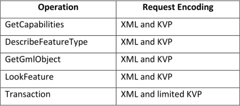
The HTTP GET method uses Keyword-value pairs (KVP) to encode WFS requests and the HTTP POST method uses XML as the encoding language. A KVP is in the format “Keyword=Value”, like for example “REQUEST=GetCapabilities”. In table 7 is shown the WFS operation and the respective request encoding.
Operation Request Encoding
GetCapabilities XML and KVP
DescribeFeatureType XML and KVP
GetGmlObject XML and KVP
LookFeature XML and KVP
Transaction XML and limited KVP
Table 7 - Operation Request Encoding
Namespaces
18
Simple object access protocol (SOAP)
The SOAP is a protocol used for communications between applications, in this case for communications between a client and a WFS server using the HTTP POST method. SOAP is also platform and language independent and SOAP messages are encoded using XML, providing a way to communicate under different operating systems, with different technologies and programming languages.
The request and response to a WFS can occur using a body of a SOAP envelope using the XML tag <soap:body>.
When an exception is encountered, the WFS response is a SOAP message where the content of a <soap:body> element is a <soap:Fault> element.
Feature and Element Identifiers
These identifiers are fundamental to make possible the use of operations over features served by a WFS. Every feature instance in a WFS has its own unique identifier, that can be used to reference repeatedly. In the same way, elements have also its own unique identifier, used to refer them.
Feature state and property names
The feature state is imperative to use the transactional WFS. When the client wants to insert, update or delete a feature instance, it is important to know the state of that feature instance, which is constituted by the values of all properties of that feature instance.
Since the feature state must be expressed in GML and thus XML, they should be valid according with the XML 1.0 specification.
Property references
19
properties from the various places where they are required (e.g. query and filter expressions).
XPath Language specification is a language used, in the case of the WFS specification, for referencing XML elements and attributes within the description of a feature, requiring thus only the support of a subset and not the full XPath language.
The <Native> element
The <Native> element was created since the number of capabilities supported by an open interface is limited. This element gives the possibility to vendors create their own specific capabilities of any particular WFS or datastore. It is composed by some attributes of which is highlighted the safeToIgnore, that can assume tow values, True or False. A value of False indicates that this element cannot be ignored and consequently if the WFS cannot deal with it, must fail. A value of True indicates that this element can be safely ignored.
Filter
The filter element is used to define a set of feature instances to operate. This filter can be based on one or more enumerated features or defined through spatial and non-spatial constraints.
Exception reporting
When an error is encountered in a WFS request, the server sends a XML document reporting this error containing one or more WFS processing exceptions.
Common XML attributes
20
in version negotiation. The service indicates which of the available services is invoked, at a particular service instance, which in this case is WFS.
2.4.2.1. WFS operations
WFS operations are detailed here such as the DescribeFeatureType operation, the
GetFeature operation, the GetGmlObject operation, the LockFeature operation, the Transaction operation and the GeCapabilities operation. All these operations require a request by the user and a response by the server.
DescribeFeatureType operation
The DescribeFeatureType operation has the intent to generate a schema description of feature types serviced by a WFS implementation. With this schema, the client get to know how encode feature instances on input and the expected output.
The request of this operation is a XML schema with some elements like TypeName
and outputFormat. The TypeName element encodes the names of feature types to be described. The outputFormat element is used to indicate the schema language to be used in the description of the features requested. The default value, in this case, indicates that a GML application schema, using XML schema, should be generated. When the DescribeFeatureType element is empty should be interpreted as requesting the description of all feature types serviced by the WFS.
21
GetFeature operation
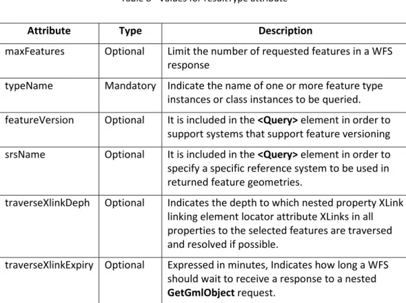
This operation allows retrieval of features from a WFS. When the value of the
outputFormat attribute is set to text/gml; subtype=gml/3.1.1, a GML3 instance document is returned to the client, with the result.
The request can contain one or more query elements, an outputFormat attribute (optional) and a resultType attribute (optional). The output format is similar to that described in the DescribeFeatureType operation. The resultType can assume two values to control the way a WFS responds to a request, as described in table 8. The other attributes are shown in table 9.
resultType value Description
Results (default value) A complete response is generated containing all the features requested.
Hits The response only contains the number of
feature instances of the requested feature types.
Table 8 - Values for resultType attribute
Attribute Type Description
maxFeatures Optional Limit the number of requested features in a WFS response
typeName Mandatory Indicate the name of one or more feature type instances or class instances to be queried.
featureVersion Optional It is included in the <Query> element in order to support systems that support feature versioning
srsName Optional It is included in the <Query> element in order to specify a specific reference system to be used in returned feature geometries.
traverseXlinkDeph Optional Indicates the depth to which nested property XLink linking element locator attribute XLinks in all properties to the selected features are traversed and resolved if possible.
traverseXlinkExpiry Optional Expressed in minutes, Indicates how long a WFS should wait to receive a response to a nested
GetGmlObject request.
22
The response to a GetFeature operation request has its format controlled by the
outputFormat attribute, like described in the first paragraph of this chapter. The root element of this response is the <wfs:FeatureCollection> element, and is dependent of the resultType attribute value, like described in table 8.
GetGmlObject operation
This optional operation allows a request of features served by a WFS, through an ID. In the GetCapabilities operation, described in chapter 0, the WFS support to the
GetGmlObject operation has to be advertised, otherwise, this operation is not allowed.
The request is made using an object ID and contains exactly one object ID. This value is used as a unique key that identifies the element at the server and could be any identified element such as a feature, a geometry, a topology, or a complex attribute. Once more, the outputFormat attribute defines the format to use to generate the result set,
The response to a GetGmlObject request is the referenced GML element returned as an XML document fragment, and differs from a response to a GetFeature request that returns the complete document.
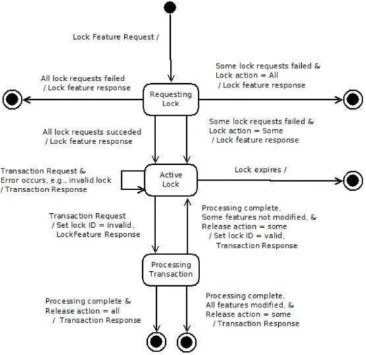
LockFeature operation
This operation is very important in transactional WFS and is related to a mechanism to guarantee that when someone is modifying a feature in the client side, no other client can update that feature at the same time in the database. Without this mechanism, the update process would not be reliable with the possibility of information loss.
23
define how long a WFS should hold a lock. The <Lock> element contains a single
<Filter> element that defines the set of feature instances of the specified feature type to be locked. The optional lockAction attribute controls how feature locks are acquired and can assume tow values, as described on table 10.
Value Action
ALL (default) All requested feature instances as to be locked, otherwise the operations fails.
SOME The WFS should attempt to lock the maximum
of requested feature instances
Table 10 - lookAction operation values
In figure 4 is presented a diagram to better understand the lock feature process.
Figure 4 - State diagram for a WFS lock (Source: Vretanos (2005))
24
locked feature instances. This file could contain also the optional elements described in table 11 depending on the value of the lockAction attribute. For the case that a WFS do not implements the LockFeature operation, the server should generate an exception with the description of the error.
Element lockAction value Description
FeaturesLocked ALL If all requested features can be locked, the
element should contain that information.
If some requested features could not be locked, the server should respond with an exception.
SOME The element should list all the features locked
FeaturesNotLocked ALL Element not present
SOME The element should list all the features not locked
Table 11 - Optional elements of a LockFeature operation
Transaction operation
The Transaction operation is used to inform, when transformation operations applied to the feature instances are completed, about their completion status, through a XML response by the server.
The request contains various elements, between them the <Transaction> element that may contain zero or more <Insert>, <Update>, or <Delete> elements. The
<Insert> element, that is used to create new feature instances, has an idgen
25
idgen value Action
GenerateNew (default) Unique identifiers of all newly inserted features shall be generated.
UseExisting gml:id attribute values should be used on
inserted features and elements. If any of those IDs duplicates the ID of a feature or element already stored in the WFS, the WFS shall raise an exception.
ReplaceDuplicate When it is intended to replace existing
values of feature elements that duplicate the ID of a feature or element already stored in the WFS.
Table 12 - Values of the attribute idgen
The response should be an XML document with the termination status of the transaction. For the case of the transaction request includes <Insert> operations, the response must report the identifiers of the entire features created. The
<TransactionResponse> element can contain a <TransactionSummary> element, an optional <TransactionResult> element and an optional <InsertResults> operation as shown in table 13.
Element Sub-element Description
TransactionSummary totalInserted Contains a count of the number of new feature instances created.
totalUpdated Contains a count of the total number of features updated.
totalDeleted Contains a count of the number of feature instances deleted.
TransactionResult (optiona)l Indicate witch actions of a transaction
request failed to complete successfully. If it is not present, then all the actions of a transaction has been completed
successfully.
InsertResults (optional) It is used when a transaction contains
insert actions, and indicates the feature identifiers of newly created feature instances.
Table 13 - Description of some elements of a Transaction operation response
26
GetCapabilities operation
Like the WMS, the WFS also must have the capacity to describe its capabilities, which is done through a GetCapabilities request.
The request is composed by a <GetCapabilities> element asking for a capabilities document from a Web feature service and the response is an XML document containing a <WFS_Capabilities> element divided into the follow seven sections:
1. Service Identification section – Information about the service itself.
2. Service Provider section – Information about the organization that provides the WFS server
3. Operation Metadata section – Metadata about the operations defined in the specification and implemented by the WFS server.
4. FeatureType list section – A list of feature types, and transaction and query operations on each feature type, that are available from the WFS.
5. ServesGMLObjectType list section – A list of GML object typesavailable from the WFS if it supports GetGMLObject operations.
6. SupportsGMLObjectType list section – List of GML Object Types that the WFS is capable of serving.
7. Filter capabilities section – defines the schema of the filter capabilities.
2.5. Conclusions
The future is inseparable from the Internet and, consequently, from distributed services, that are gaining territory to the isolated Desktop GIS. The distributed services are also inseparable from the interoperability concept to become more and more usable by everyone.
27
28
3.
Framework definition
3.1. Introduction
There is a vast number of software that handles GI - some are for desktop use, others for mobile use, and others act like servers.
For purpose of implementing the prototype, and according to the dissertation objective, it is necessary to select software that implements the WFS-T OGC Specification, both for server and client.
Thus, a server software that handles transactional operations via WFS is needed and also a client application that implements tools to deal with these operations.
In this chapter the system architecture and requirements are discussed, based on the results of some software tests and research, which aims at verifying what software is prepared to deal with the WFS-T standard.
3.2. System Architecture
Given the fact that the author of this work is more familiarized with Windows from Microsoft, all the system architecture discussed here is based on this operating system.
It is important to identify a system that implements the WFS-T OGC Specification. For this, a server and a client, at least, are needed, but it is also possible to add a database server with spatial capabilities and/or provide tools for Web access. To be able to access through a Web browser, an application that provides the tools to put the map in an HTML page or other Web language and a Web server to make available it over the WWW are necessary.
29
Figure 5 - System architecture
The adoption of Web Tools allows the use of simple Web browsers instead of desktop applications (Open Source, commercial, or even other type of applications), with the possibility of accessing to it anywhere - through an internet connection and an installed Web browser.
3.3. Available Software
To implement the proposed system architecture, software compatible with the OGC specifications is needed for all sections: Data, Server and Client sections. In the next sections, software possibilities are presented and analysed by section and the best set that fits the defined architecture will be selected.
3.3.1. Data section
To store the data there are a few possibilities, like the Shapefile from ESRI or some database formats. By recurring to a database, it is possible to use structured data with all the inherent advantages (Paul A. Longley, 2005):
• Redundancy reduction;
• Integrity maintenance;
• Better organization with maintenance costs and data manipulation reduction;
• Establishment and enforcement of security and standards for data and data access, among many others.
Database
WFS-T Desktop
application
Web Browser Web Server (Web Tools)
30 Available database software includes:
• PostgreSQL / PostGIS (PostgreSQL (2009) / Refractions (2009)) – PostgreSQL is an Open Source object-relational database system widely used by many organizations all over the world. Its development has started at the University of California and, at the moment, by a network of contributors. PostGIS adds support for geographic objects to the PostgreSQL and has been developed by Refractions Research as a project in Open Source spatial database technology. This is one of the most used database systems in the GI domain (Salinas and Lajara, 2009).
• MySQL – MySQL is Open Source database software that has a spatial extension to deal with GI. Paul Ramsey wrote, in June 2009, an article comparing this Open Source database software with PostgreSQL and have reached interesting results, i.e. “the amount of functionality in MySQL Spatial remains very very small” (Ramsey, 2009);
• Oracle Spatial – Commercial database software with a spatial extension to deal with GI by Oracle Corporation;
• SQL Server 2008 - Commercial database software with a spatial extension to deal with GI by Microsoft Corporation.
3.3.2. Server section
Servers are an important piece of client-server systems. They provide data based on standards, which are a set of rules to communicate and transfer between both sides. At this section, we have the WFS-T server and the Web server.
3.3.2.1. WFS-T Server
31
Some existent server software implements only the WFS specification, without Transaction operation capabilities.
Available software with WFS Server includes:
• GeoServer (Geoserver, 2009) - GeoServer is an Open Source software server written in Java in a contributor environment, with the financial support of various institutions. This software implements the WFS-T OGC Specification;
• ArcGIS Server (ESRI, 2009) – This software does not implement the WFS-T OGC Specification. It only implements the WFS OGC Specification with no support to transaction operations;
• Map Server (MapServer, 2009) – Like ArcGIS Server, this software does not implement the WFS-T OGC Specification, but only the WFS specification without transactional support.
3.3.2.2. Web Server
A Web Server is fundamental to make data or Web tools available in the WWW through Web applications. Without it, there are no possibilities to work with GI, or other kind of data, using a simple Web browser.
One of the most used Web server in the world is the Apache Web Server (Apache, 2009), with the advantage of being Open Source software. The Microsoft Web Server, called Internet Information Services (IIS), is also available. These are two of the most Web Servers used all over the world.
3.3.2.3. Web Tools
32
The available software toolkits for Web tools development are:
• OpenLayers (OpenLayers, 2009a) – It is an Open Source map viewing library and makes it easy to incorporate maps from a variety of sources into a Webpage;
• ka-MAP (ka-MAP, 2009) – It is also an Open Source project that aims at providing an API for developing highly interactive Web-mapping interfaces using features available in modern Web browsers. This software is developed to work with Map Server;
• Mapfish client (MapFish, 2009) – Based on Open Layers, it supports the latest Web 2.0 technology, including the OpenLayers, ExtJS and GeoExt JavaScript toolkits;
• MapBender (MapBender, 2009) – It is an Open Source Geospatial Foundation project for geodata management of OGC OWS architectures.
3.3.3. Client section
This section represents the client side of the prototype. The client can access the data through a Web application via WWW or a desktop application. The first option uses Web development based on Web tools presented in section 3.3.2.3 and the second uses an available desktop application from those presented below in section 3.3.3.1.
3.3.3.1. Desktop Applications
33 Some of the available software applications are:
• gvSIG (gvSIG, 2009) – Open Source software that implements the WFS OGC Specification. The tools to manipulate GI are only available through an extension that is, at the moment, under development;
• uDig (uDig, 2009) - Open Source software that implements the WFS OGC Specification with transaction operations support. The goal of this project is to bring internet mapping technologies such as WMS and WFS transparently to ordinary GIS users desktops (Ramsey, 2007);
• Kosmo (Kosmo, 2009) – Open Source software that does not implement the WFS OGC Specification;
• OpenJump (OpenJump, 2009) – Open Source software that also does not implement the WFS OGC Specification;
• QuantumGIS (Quantum GIS, 2009) – Open Source software that implements the WFS OGC Specification, but does not have support to transaction operations;
• ArcGIS (ESRI, 2009) – Proprietary software that implements the WFS OGC Specification through an extension called Interoperability. It does not have support to transaction operations;
• Cadcorp SIS (Cadcorp, 2009) – Proprietary software that implements the WFS OGC Specification without support to transaction operations;
• Geomedia (Intergraph, 2009) – Proprietary software that implements the WFS OGC Specification without support to transaction operations;
• Supermap (SuperMap, 2009) – Proprietary software that implements the WFS OGC Specification without support to transaction operations.
3.4. Selected software
34
not serve the purposes of the framework. Since the GeoServer is the only software that fully implements this standard, it was the first software selected to make part of the system. The chosen version was the last one available at the moment of the writing of this thesis - the 1.7.4 version.
The Apache software was the choice for the Web server because it is Open Source and one of the most used in the world, with very good performance and stability. To facilitate its installation, it was decided to use an “easy to install” Apache distribution called XAMPP (XAMPP, 2009).
After this, the decision was to use the PostgreSQL/PostGIS for the database section, since the combination of GeoServer with PostgreSQL/PostGIS is widely used with also very keen results.
For the Client section, it was decided to use both Web tools and desktop software to improve the prototype: Mapfish client for the Web tools and uDig for the desktop. The Mapfish because it is a set of java libraries with strong graphical skills and WFS-T standard implementation, and the uDig because it is the only desktop software that implements the WFS OGC Specification, with tools and support to transactional operations.
Summarizing, the chosen software for the entire prototype is presented in the table 14 and figure 6.
Section Type Name
Data section Data base PostgreSQL (v8.3)/PostGIS (v1.4.0)
Server Section WFS-T server GeoServer (v1.7.4)
Server Section Web server XAMPP (v1.7.2) containing Apache (v2.2)
Server Section Web tools MapFish (v1.2) including OpenLayers (developer version)
Client section Desktop application UDig (v1.2-RC3)
Client section Web browser Mozilla Firefox
35
Figure 6 - System architecture with selected software
3.5. FOSS vs. Proprietary Software
Like written in the previous section, all the selected software is FOSS since no proprietary software implements the WFS-T standard, which leads us to think about that. One of the ways to try to understand this phenomenon is to take a look at the advantages and disadvantages of proprietary and FOS software, presented by Steiniger and Bocher (2009), adapted from Weis (2006), in table 15.
Proprietary software is based on a model where the source code is closed. The FOSS model is based on an opposite way, and permits allow users to modify a product's source code (Wikipedia, 2010).
FOSS implies free software that is a matter of the users' freedom to run, copy, distribute, study, change and improve the software (GNU, 2010).
Data section Server section Client section
PostgreSQ L/PostGIS
GeoServer uDig
Mozzila Firefox
36
Free & Open source Software Proprietary software
Advantages
• no licence fees
• unrestricted use (e.g. no limits for the number of • installations)
• no update enforcement • support of open standards • support usually available
from several providers • customisation at API level
• warranty of developing company on product • components should work
together
• usually well documented software
Disadvantages
• installation know-how necessary
• training costs
• software price and maintenance fees • training costs
• maintenance tied to specific licensed companies
• customised development can be difficult due to • available resources of
vendors
• support only as long as software company exists Table 15 - Advantages and disadvantages of proprietary and FOS software, presented by Steiniger
and Bocher (2009) adapted from Weis (2006).
3.6. Conclusions
As it is described in this chapter, there is a considerable amount of software that deals with GI, but only few implement the WFS-T Specification. Among these, only some implements the Transaction mechanism at the server level, as well as at the client side level.
37
4.
Prototype implementation
In this chapter, the prototype implementation is described, based on the selected software presented in chapter 3. It begins with the software download and installation and their configuration, where the developed application is also described.
4.1. Introduction
This prototype aims at registering the existent dumps in Portugal, enabling the user to use a web or a desktop application, through the WFS-T OGC standard.
After the software definition, it is necessary to download, install and configure the system software so that it works properly. The Web application development is also required.
It is important to note that all the downloaded installation packages should be selected for windows Operating Systems (OS) because this prototype implementation is based on that OS. It is also important to refer that all these software packages are also available for Linux and others OS.
4.2. Software download and installation
The first thing to do is to download the software defined in the system architecture (chapter 3.2). This can be done through the Web pages of each software once they all are FOSS with this possibility. After that, it is necessary to install each of them, following the installation instructions that are available, normally at their home pages or in the installation package.
38
4.2.1. XAMPP
The “easy to install” Apache distribution was downloaded from the XAMPP project Web page, choosing its windows distribution. The installation was made by using the EXE installer that was included, and according to the installation instructions.
4.2.2. PostgreSQL/PostGIS
On the PostgreSQL Web page, the windows installer package was downloaded and installed. This package installs i) a precompiled version of PostgreSQL along with pgAdmin (a graphical administrator that makes the PostgreSQL administration and management easier), ii) a selection of modules to provide additional specialised functionalities, and iii) a choice of procedural languages. With these modules came also the PostGIS that can be selected to install after the PostgreSQL installation. This module can also be downloaded and installed alone from its own Web page.
4.2.3. GeoServer
GeoServer is written in Java and requires the Java Development Kit (JDK) installed on the computer in order to run. The JDK and can be downloaded from the Sun Java downloads Web page (Java, 2009) and it is only necessary to run the installer, accepting the defaults.
Then, the GeoServer should be downloaded from its Web site and installed. The installation process it is also very easy by following the instructions provided on the user manual.
4.2.4. MapFish
39
4.2.5. UDig
For the installation of the uDig application, it is necessary to access its Web page and download the x86 installer for windows. After that, it is necessary to run it accepting the defaults to installation purpose.
4.3. Configuration
After all the software installation, it is necessary to configure the system, i.e. prepare the database and server to provide the necessary data through the WFS-T specification and, arrange the desktop and develop the Web application to access and manipulate the data.
4.3.1. Database preparation
The first thing to do is to create a PostgreSQL/PostGIS database and, inside it, a table to handle the dumps data, defining also the attributes to register, the geometry and the coordinate system. It was decided to use the polygon as geometry and the EPSG 4326 as the Coordinate Reference System (CRS). EPSG refers to the EPSG Geodetic Parameter Dataset, abbreviated to the EPSG Dataset and maintained by the OGP5 Surveying and Positioning Committee's Geodetic Subcommittee (OGP, 2009).
The EPSG 4326 refers to the WGS84 datum, and was used because the developed web application has a base layer from Google maps that is in the same CRS. It was also determined to create four columns to store the attributes: name, type of garbage, terrain topography type and terrain access type.
Note that it is advisable for all the Database (DB) creation, for spatial purposes, to be based on a spatial template that is created when the PostGIS module is installed, called “template_postgis”. Through this, every new DB, created under these assumptions, came already with two imperative tables: the geometry_columns and
40
the spatial_ref_sys. The first one is used to register the geometry columns of the DB spatial tables and the second one has the reference systems parameters.
The geometry_columns table has some important columns to fill for every spatial table that exists in the DB: the f_table_name, the f_geometry_column and the srid column. These columns have to be filled with, respectively, the spatial table name, the column that has the geometry data and the spatial reference. In the srid column, a value that exists in the spatial_ref_sys table must be inserted.
Moreover, a spatial table is created with every defined columns and a more special one to record the geometry, called the_geom. This column has to be registered in the geometry_columns table, as described above.
4.3.2. GeoServer preparation
After the DB creation and configuration, it is important to configure the server to provide the dumps data through the WFS-T standard.
First, it is necessary to start the GeoServer, using the shortcut called “Start GeoServer”, located inside the GeoServer folder at the windows start menu. In the same location it is possible to open the Web Administration Tool, required to proceed to the next step.
The next step is to configure, through that tool, the data to provide and the WFS parameters. In the WFS configuration, accessed through the Config/WFS/Contents options at the main menu, it is important to ensure that the transactional service level is activated. Otherwise, transactions will not be allowed.
41
Feature Servers. It is in the feature type configuration that the schema base is provided. Parameters like the alias, the style, the spatial reference system, the title or the bounding box for the entire feature type, between others, are established.
4.3.3. uDig preparation
The uDig software preparation starts by adding, after opening the program, a new WFS layer through the Layer/Add... menu and selecting the Web Feature Server option, as it is shown in figure 7.
Figure 7 - Add data form
42
Figure 8 - URL of wfs GeoServer
After completing the wizard, the layer is shown in the uDig program interface as presented in figure 9.
Figure 9 - WFS layer on a uDig map
43
Figure 10 - Editing WFS layer on uDig map
To improve the uDig component of the prototype it would be interesting to use some imagery of the work area as context information. This would facilitate the recognition and interpretation of the geographical locations, where dumps are being registered, edited or deleted.
4.3.4. Web client application development
44
Figure 11 - Layout
As described in chapter 3.4, the Web client application was developed using Mapfish client software that is based on the Openlayers, ExtJS and GeoExt java script libraries. Therefore, all the programming is done using java script language. In the next sentences, some of the most important portions of code are detailed. It is important to understand one of the first difficulties felt in the development – the proxy configuration. In the Frequently Asked Questions (FAQ) of the Openlayers wiki Web site (OpenLayers, 2009b), one can read: “Due to security restrictions in Javascript, it is not possible to retrieve information from remote domains via an XMLHttpRequest. Classes like WFS and GeoRSS use XMLHTTPRequest to get their data. If they are querying a remote server (anything other than the machine hosting your page), you must install a proxy script somewhere Web accessible on that machine. See below for how to set up your own ProxyHost. If the OpenLayers.ProxyHost variable is not set to a valid proxy host, requests are sent directly to the remote servers. In most cases, the result will be a security exception, although this exception often occurs silently”. Consequently, a proxy server was installed in the local machine and the OpenLayers.ProxyHost variable was defined pointing to that proxy server location.
The next important thing to do is to include, in the developing Web application, the location of the mapfish.js, openlayers.js, ext.js and geoext.js library files, so they can
Title
Layer tree
Other information
Dumps information Toolbar