Tracking tourists in a Gamification Process: a
theoretical approach
ALBERTO SIGNORETTI * [[email protected]] MÁRCIO MARTINS ** [[email protected]]
Resumo | Este artigo propõe uma abordagem teórica à utilização de novas tecnologias de rastrea-mento de turistas: uma aplicação (app) de smartphone baseada num dispositivo de G.P.S (Sistema de Posicionamento Global) e associada a um processo de gamificação. Destinado a incentivar os turistas a partilhar o seu comportamento espaço-temporal durante a sua estadia, esta app permite recolher informação relacionada com os movimentos turísticos, como a territorialidade, padrões de movimento, orientação e locomoção e como a visita multi-atração é muito comum em visitas em destinos urbanos, fornece ainda um conjunto de dados relativos à intensidade e especificidade da visita. Baseada em tecnologia de G.P.S., tem a vantagem de associação com outras tecnologias avançadas, tais como S.I.G, Google Earth ou outros, é muito precisa em áreas urbanas devido à elevada cobertura de rede e não é muito intrusiva. Apesar de limitada à vida útil da bateria do smartphone foi projetada para rastrear sem conexão com a internet e enviar os dados automaticamente para a "cloud "assim que seja encontrada uma conexão sem fios. Uma das principais inovações introduzidas é a possibilidade de rastrear os tu-ristas durante toda a sua estadia sem ser intrusiva, contribuindo para uma compreensão mais profunda do comportamento espaço-temporal dos turistas, tornando simultaneamente a sua visita mais divertida, apelativa e proveitosa.
Palavras-chave | Comportamento espaço-temporal dos turistas, tecnologias de rastreamento, gamifi-cação
Abstract | This article proposes a theoretical approach to the use of new technologies to track tou-rists: a smartphone application based on GPS devices associated to a gamification process. Designed to encourage tourists to share their time and space behaviour during their stay, it allows to collect information related with the tourist movements, like territoriality, movement patterns, orientation and locomotion. As the multi-attraction visit is very common while visiting a urban destination during the multi-destination trips, it will provide a set of data related to the visit intensity and the visit specifi-city. Based on GPS devices, the association with other advanced technology, has advantages such as GIS, Google Earth or others, is very accurate in urban areas due to high coverage, and it is not very intrusive. Despite being limited to smartphone battery life it was designed to track them without an
*Doutor em Engenharia Elétrica e de Computação pela Universidade Federal do Rio Grande do Norte, Professor Adjunto na Universidade do Estado do Rio Grande do Norte, Dpto. De Ciência da Computação.
**Doutorando em Turismo na Universidade de Aveiro. Membro colaborador da unidade de investigação em Governança, Competitividade e Políticas Públicas (GOVCOPP) da Universidade de Aveiro. Docente na Escola Superior de Educação do Instituto Politécnico de Bragança.
internet connection and to send data automatically to the “cloud” as soon as a wireless connection is found. One of the most innovative methods is the possibility to track tourists not for only one day but for all the entire stay without being intrusive, contributing to a deeper understanding of tourist’s space and time behaviour. It provides, simultaneously a much more appealing and profitable visit to the tourist.
Keywords| Tourist space-time behaviour, tracking technologies, gamification
1. Introduction
Despite still being one of the most popular forms of tourism, urban tourism is still a less studied phenomenon (Shoval, McKercher, Ng, & Birenboim, 2011) and because tourists and resi-dents usually have different activities some chal-lenges, problems and conflicts might occur. Tou-rists’ behaviors always take place in time and space and consequently, understanding their space and time behaviour like tourist activities, places visited, the time they spend and the facilities and services they use, can contribute to the improvement of destination management, the development of the product and the marketing of attractions; to the planning and location of infrastructure and new at-tractions, minimizing adverse impacts on sensitive destinations; to the development of transport and destination planning; to respond to the impacts of tourism, influencing appropriately the tourists behavior redirecting tourist flows to avoid over-crowding; to identify potential places for leisure activities; to improve tourist information, tourist signs and relating the tourist spatial behaviour to the evaluation of experience (Caldeira, 2014; Lew & McKercher, 2006; Pettersson & Zillinger, 2011; Toha & Ismail, 2015; Van der Knaap, 1999). For these reasons, understanding urban tourist flows will give an important contribution to improve the city management in a smart city environment.
This work aims to give a theoretical contri-bution to the development of a smartphone ap-plication in order to collect a set of data related
to tourists’ space-time behaviour without inducing them to follow a certain path or using particular services. Based on GPS devices, can be associ-ated with other advanced technology, is very ac-curate in urban areas due to high coverage and being not very intrusive. Despite being limited to smartphone battery life it was designed to track without internet connection and to send data au-tomatically to the “cloud” as soon as a wireless connection is found.
In this App, tourists are invited to follow the instinct of the 15th century Portuguese sailors who ventured for uncharted waters. In this context they are induced to know some of local History and are encouraged to share their discoveries in social networks. In addition it is possible to obtain virtual rewards and allow a connection to the real world through the association of some touristic services that wish to participate offering real prizes to items virtually achieved. Tourists can also upload real photos into the app, write their comments and be invited to answer some questions about their con-sumption patterns in order to know how much they spend. One of the most innovative method is the possibility to track tourists not only one day but the entire stay without being intrusive, contribu-ting to a deeper understanding of tourist’s space and time behaviour. At the same time aims to pro-vide the most fun, appealing and profitable visit to the tourist.
2. Tourist space-time behaviour conceptuali-zation
Touristic activity necessarily entails the move-ment of tourists and not only the movemove-ments per-formed by the tourists until the destination but also the movements performed within the destination itself, are conducted in a given territory (space) and in a variable duration (time). An important consideration in tourist space–time behavior analy-sis is the aggregation of tourist space–time paths to create generalized types and to extract pat-terns that consider sequential elements quantitati-vely (Shoval & Isaacson, 2007).
Independent tourists have a great deal of dis-cretion in how they can spend their time budgets, particularly in a multi-attraction visit. Hence, they are the subject of this project. Time used in de-cision making process is related to the absolute amount of time available and to the set of acti-vities that tourists wish to consume during their stay (McKercher, Wong, & Lau, 2006). The ac-tivities tourists take part in, where and how they sequence their visit, deals with the micro-spatial and temporal dimensions of tourism analyzed by Grinberger, Shoval & McKercher (2014) and it is this perspective that will be adopted in order to understand the tourist consumption of a desti-nation. The understanding of the tourist flow of movement in the cities, is a fundamental set of data to improve the city management in a smart city environment. In this context it recommended the possibility to integrate the flow of tourists and the normal city flows avoiding the stress to the tourists and to local citizen daily activities (Curry, Dustdar, Sheng, & Sheth, 2016).
Intra-destination movement patterns of tou-rists has been object of research in several studies (McKercher, Shoval, Ng, & Birenboim, 2012;
Sho-val et al., 2011; Xia, 2007; Xiao-Ting & Bi-Hu, 2012) and in order to understand the importance of these studies and the methodology they used it is relevant to identify the factors that influence both the intensity and spatial dispersion of move-ments. These factors will then be embedded in the smartphone application prototype conceptualized in this proposal.
Xiao-Ting & Bi-Hu (2012), classify the tourist behaviour patterns studies according to socio-demographic or psychological factors and accor-ding to the tourist behaviour characteristics, give special attention to the typical behaviour patterns. Grinberger et al., (2014) suggest that the tourists study behaviour has been extended to other to-pics such as the choices of destination, the tourist experience, the segmentation of tourists and the tourist consumption of the destination. But in general, the studies about tourists space and time behaviour highlight several factors on which they have focused: the origin or cultural background of tourists (Dejbakhsh, Arrowsmith & Jackson, 2011); first-time and repeat visitors (McKercher et al., 2012; Oppermann, 1997); special interest of tourists (Fennel, 1996); the type of trip destina-tion and tourist characteristics (Lew & McKercher, 2006); Hotel location (Shoval et al., 2011); first and last day of the visit (Mckercher & Lau, 2008) or sociodemographic characteristics of tourists, like age, gender, household income and educatio-nal background (Driver & Tocher, 1979; Hanson & Hanson, 1981 cited by Dejbakhsh et al., 2011; Caldeira, 2014). Other researches focus their at-tention on tourist satisfaction (Caldeira, 2014), the impact of distance travelled from the coun-try of origin (Caldeira & Kastenholz, 2015) and on environmental sustainability (Dickinson et al., 2013; Edwards & Griffin, 2013).
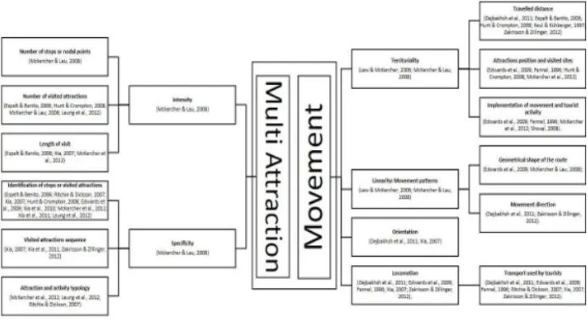
Figura 1 | Operational and conceptual dimensions of tourist space-time behavior.
Source: Dejbakhsh, Arrowsmith, & Jackson (2011); Edwards, Griffin, Hayllar, & Dickson (2009); Espelt & Benito (2006); Fennel (1996); Hunt & Crompton (2008); Leung et al. (2012); Mckercher & Lau (2008); McKercher, Shoval, Ng, & Birenboim (2012); Ritchie & Dickson (2007); Shoval (2008); Xia, Zeephongsekul, & Packer (2011); Xia (2007); Zakrisson & Zillinger (2012). Own
construction.
As tourists physical movements and consump-tion behaviors are visible, they can be quantified, measured and even predicted (Xia, Zeephongse-kul, & Packer, 2011; Xiao-Ting & Bi-Hu, 2012), so, in order to find out what tourists do and where they go, a behavioral perspective based in their objective and observed movements should be adopted. And to understand it, a special attention should be given to the dimension of “movement” and to the dimension “multi-attraction” (visited attractions). The literature review about tourist space-time behavior allowed to find a set of varia-bles organized in two operational and conceptual dimensions previously presented: the dimensions
of “movement” and “multi-attraction” (fig.1) used and conceptualized in Caldeira’s research (2014). Each dimension is constituted by a set of fac-tors: territoriality, linearity (movement patterns), orientation, locomotion, intensity and specificity (fig.1). There is also a set of factors that influ-ence the movement of tourists in space and time: internal factors (related to the tourists themsel-ves) and external factors (Zillinger, 2007, cited in Caldeira, 2014) identified as well by Lew & Mc-Kercher (2006) as destination features and tourist features, operationalized by Caldeira (2014) as tourist features and visit characteristics (fig.2).
Figura 2 | Tourist features and visit characteristics
Source: Becken & Simmons (2008); Caldeira & Kastenholz (2015); Caldeira (2014); Celata (2012); Dejbakhsh et al., (2011); Edwards et al., (2009); Espelt & Benito (2006); Fennel (1996); Koo, Wu, & Dwyer (2012); Lew & McKercher (2006); Mckercher & Lau (2008); McKercher et al., (2012); Moore, Smallman, Wilson & Simmons (2009); Oppermann (1997); Pas (1984); Shoval, et al.,
(2011); Shoval & Raveh (2004); Weaver (2012); Xia (2007); Zakrisson & Zillinger (2012). Own construction.
The GPS (Global Position System) technology has been the most used to track tourists and is very well documented in literature (Grinberger et al., 2014; Mckercher & Lau, 2008; McKercher et al., 2012, 2006; Shoval & Isaacson, 2007; Shoval et al., 2011; Shoval, 2008). In fig.3 we present the main advantages and disadvantages of modern tracking technologies.
Understanding where tourists go within a city and how they negotiate their way from one point of interest to the next is not something discovered through subjective observation (Edwards, Dick-son, Griffin, & Hayllar, 2010 cited in Caldeira, 2014). So, tourist spatial-temporal behaviour can be understood through the tracking of tourists in order to allow to know their physical movement in space and time (Xia et al., 2011). In the em-pirical studies about tourist mobility, traditional and modern methods can be used. Versichele et al. (2014) admit that this kind of studies using traditional methods like direct observation or
per-sonal interview, are not very common due to their labor-intensive and often expensive nature. Other traditional methods, like space time diaries are characterized by a low reliability. For these rea-sons a new set of modern tracking technologies has been used in several studies in order to get more accurate data about tourist’s movements. Through the analysis of fig.3, GPS tracking te-chnology and smartphone application based on GPS, despite their limitations and disadvantages, are the most appropriate technologies to track tourists. But the use of GPS in this kind of empi-rical studies are limited by the low sample size of tourists, by the long time frame to track tourists, by the difficult survey of tourist motivation being part of the study, by the limited battery life of GPS logger and the expensive nature of the equip-ment. Besides being intrusive, GPS tracking can be also limited by signals blockage from buildings and foliage.
Quadro 1 | Advantages and disadvantages of modern counting and tracking technologies
Sources: (a) Toha & Ismail (2015), Xia (2007), Yun & Park (2014); (b) Xia (2007); (c) Zoltan & McKercher (2014); (d) Toha & Ismail (2015), Yun & Park (2014); (e) Versichele et al. (2014). Own construction.
Smartphone APP’S based on GPS devices offer ever-more-useful and practical information about time and space (Shoval & Isaacson, 2007; Sho-val, 2008) and has the advantage of association with other advanced technology present in current smartphones and, as the prior, can be also asso-ciated with other technologies such as Geographic Information System (GIS), Google Earth, and so on (Yun & Park, 2014). Using a Smartphone with an application based on GPS we still have some of the GPS limitations. Although more accurate in urban areas due to high coverage, still is intrusive with difficult survey of motivation and limited by battery life of smartphone. As a new technology there is the possibility to get only young partici-pants with consequences in the small sample size and representativeness of captured data (Yun & Park, 2014), however smartphones and other
te-chnological devices are becoming widespread whe-reby the development of an APP with a gamifica-tion process, intuitive and user friendly can help to solve this problem.
Having regard to the limitations of the exis-ting technologies and the inherent needs of tou-rists’ space-time behaviour researches, we suggest the creation of a new smartphone application that allows carrying out the tracking of tourist move-ments during a day visit or even during all their stay, without the necessity to adopt additional de-vices as GPS logger. Using information generated by GPSA, accelerometer, digital compass and the digital clock, along with the meta information pro-vided by the camera device, a set of data can be raised in order to assess the items described above in a very precise way. The difficulties in the survey of tourist motivation can be reduced through the
gamification process that give the tourists the op-portunity to record all their stay with routes, pho-tos and several comments that could be shared in social networks. There is also the possibility to in-troduce an offer, like hotel discount or others in order to encourage tourists to participate in parti-cular researches. The application doesn’t need the smartphone to have an internet connection during the tracking, so the problem raised by the high cost of "roaming"will not prevail. All informa-tion stored by the mobile device will be automati-cally transferred to the "cloud"as soon as a Wi-Fi network is detected. This way, the device battery won’t be fully committed, although the current smartphones already have excellent performances in what regards to battery life. The introduction of a gamification process associated to tracking also allows the tourists encouragement to respond to a set of questions that will be introduced throughout their stay without the application of a question-naire on paper. After downloading the APP tou-rists should make their registration using data from their social network like Facebook, authorizing the sharing of their biographical data with the App. The gamification of this data acquisition process serves to create a playful environment where users feel encouraged to participate and to provide the necessary data. This App, which we call the “21st Century Explorer” (21CE) induce the most fun and interesting visit, appealing and profitable for the tourist.
3. Gamification process project
After collecting and analyzing all the data it is possible to know and understand the tourist’s space-time behavior, like what are the preferenti-ally used routes, modes of transport, time spent in each place, money spent by day, attractions satis-faction, among others. According to Kapp (2012), a game is a system in which players engage in an abstract challenge, defined by rules, interactivity and feedback which results in a quantifiable out-put and which often causes an emotional reaction. According to the author, it is important to rea-lize that gamification does not address the simple adoption of game rewards of mechanical in pro-cesses that are not games. Thus, gamification can be defined as a careful application of the design thinking of games used to solve problems (Wer-bach & Hunter, 2012; Zichermann & Cunningham 2011). In terms of the proposed platform, ga-mification was thought to encourage interaction and learning, using all appropriate elements of the games. Nowadays gamification is present in vari-ous services such as listening to music (Last.fm), watching television (GetGlue) or exercise monito-ring (Fitocracy, FitBit, Nike+). These services use game elements like badges, rewards, clear go-als with immediate feedback, leaderboards and monitoring the mastering process seem to entice users to reuse these services. In addition to the game elements previously mentioned, one of the most essential is the social process based on the sharing of results and the possibility of interperso-nal interaction (Hamari & Koivisto, 2013; Hamari Koivisto & Sarsa, 2014; Hamari, 2015).
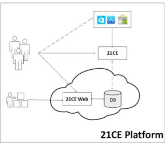
Figura 3 | General framework of 21CE platform
The use of a mobile platform such as Smartphones consists on a process of creating a pervasive and ubiquitous application about an in-creasingly present and inseparable device of a ci-tizen’s life. Smartphone devices include, in their great majority, a set of sensors that allow multiple measurements related to their users if previously allowed by them. Using information generated by GPSA, by accelerometer, by the compass and clock and by the meta information provided by camera device and from the data of social networks as Fa-cebook, it is possible to get a set of information that can be used for assessing the items described in a very precise way (fig.1).
The choice of gamification in this data ac-quisition process serves to create a playful envi-ronment where users feel encouraged, not only to participate but also to provide the necessary data. The platform proposal is designed to be flexible, allowing the participation of different de-vices with different operating systems: iOS and Android, for this reason it was decided to build the mobile application in the development environ-ment HTML5/CSS3/JS. The proposal App plat-form will have a mobile application that will serve to collect data and to be the mobile user interface, as well as a web application that will be used to access a set of more general information like user accounts and for the reports generation from the data provided by participating users. In this site
it is also possible to manage the participation of any partnerships established with institutions, or-ganizations and private companies that pretend to collaborate with this application, allowing access to information from users and providing of gifts, bonuses or promotions as well as the receiving con-ditions for participants. Figure 3 shows the general characteristics of 21CE platform.
3.1. App Story
In the 21st century few places on earth are still considered unexplored, but the power of techno-logy to put a virtual look in practically every corner of our inhabited world allows us to travel virtually almost anywhere. To observe a place through a virtual process, no matter how immersive it is, still doesn’t allow us to have the same physical expe-rience of being there. Physical contact with the environment and atmosphere of the place is so-mething we can’t have virtually, yet. Therefore, a real travel still provides a large range of unique sensations. In addition to the sensations there is a complex process related to how these sensations were experienced. And this app is designed to ex-plore the experience of these travel sensations.
For many years, along with Spain, Portugal was the stage of a series of uncharted water adventures. The navigation Discoveries led to the overseas
ex-pansion process that in addition to these two main protagonists had the later interest of England, Hol-land and France. In the 15th century, Portuguese Discoveries were boosted by several factors such as insufficient precious metals for minting currency, lack of agricultural products and labor, need for new markets, the early establishment of a national state, the desire to expand the Christian faith, the nautical knowledge and a favorable geographical position. Some noteworthy Portuguese navigators are presented in Fig.4. In the gamification process the tourist adventure in Portuguese territory will be called the “21st Century Portuguese Periplus”. In this adventure every tourist becomes an explorer and assuming the avatar of one of the great na-vigators mentioned above will explore Portuguese territory in search of their achievements. In this process, the tourist/explorer will be encouraged to show what he discovered and how he explored the visited places. All findings and achievements could be shared with friends through social networks and the tourist/explorer could also launch challenges to their friends. Once they have accepted and
succes-sfully completed, tourists/explorers can get some extra points.
3.2. Gameplay .
Tourists access the App in their mobile device APP store, download it and run the installation, accepting the access that is required by the plat-form. Once installed, the App starts to require the user to log in, through their Facebook account and using some of the information available in the social network to complete tourist registra-tion. Then the tourist chooses his avatar from the ones available in Figure 4. From this point the adventure begins. Tourists may become explorers making the registration by the Web site of the App platform. The login process is similar to that made in the APP and allows the users to visu-alize their achievements and all information that was collected by their mobile device APP. In the Web application tourists/explorers can also edit the data obtained by the mobile APP.
Figura 4 | Portuguese navigator’s avatars available in App.
Source: http://fotos.sapo.pt/conceicaojaneiro/fotos/?uid=qo20Q8ZVDFsL90w5bSKI consulted on 30th July 2015. Own construction.
Through the App Web site all tourism institu-tions, organizations and firms who wish to join this
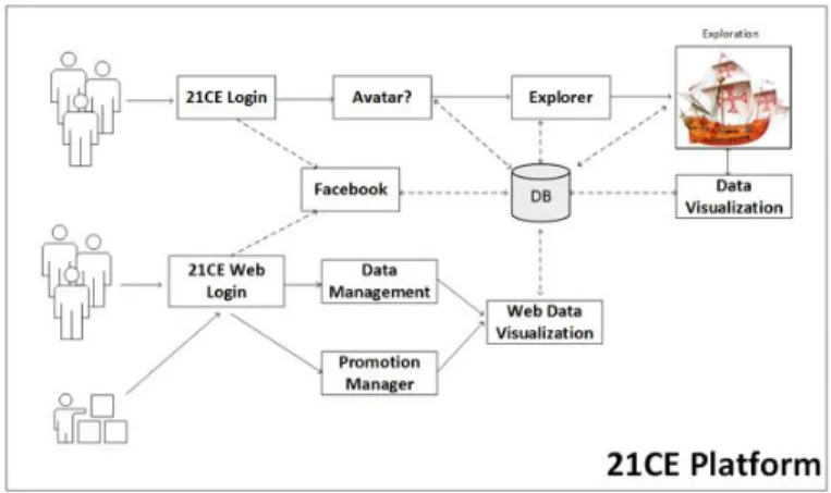
gamification process can make their registration, offering gifts or deals to App users. Figure 5 shows
the flow of the gamification process regarding both to the mobile APP and the Web APP. Each ex-plorer, when using the 21CE APP on his mobile device will record day by day the route of his dis-coveries. The APP operates without the need of continuous Internet connection (configurable), and all collected data and realized achievements will be stored locally. When the browser is connec-ted to WiFi, data is synchronized with the server in the cloud but if the tourist/explorer configures the possibility of using the data packet, this synch-ronization can occur in real time. The 21CE APP is designed to make use of sensors available in the tourist/explorer smartphone in order to track the tourist’s movements. Mobile tracking operation is always dependent on the available sensors, at least GPSA and the accelerometer are required. If these sensors are not available, the APP warns the tourists about the elements that will be part of tracking. The Explorer can perform their mo-vements in the tourist destination in many ways. The 21CE considers the following types of
trans-port: on foot, by bike, by car (owned or rented) and by train. When the mobile device is tracking, movement speed informed by GPSA will be used to distinguish the different types of ground mo-vement. The Explorer/Tourist can also check the land transportation adopted by the APP and make any corrections if necessary. Tourists/Explorers achievements and their respective scores will be taken into account only if all tracking movements were informed by GPSA. When GPSA data indica-tes a territory change, from one city to another for example, without tracking, the APP prompts the user to rectify how he gets there. If the transfer aerial, the APP is programmed to ask about the flight data. This information will then be checked for the movement validation and achievements’ scores effect. Points, and tourist/explorer achie-vements are earned through a number of combined factors that are transformed into points by using weights which give more or less significance to the actions.
Figura 5 | 21CE Platform Flow
Particular attractions, when visited, will give access to challenges previously introduced in the platform. These challenges operate independen-tly of the platform and thus can be developed by others (tourism firms or institutions, among others) who want to provide entertainment and
information to the Tourist/Explorer. The points that are conquered in these challenges are incor-porated into the explorer’s score as well. In this case it is only required that the challenges being consistent with the platform plot and following the same design guidelines. The platform also provides
a set of information about the visited destination, so to explore the territory, the explorer/tourist will have access to several information pages that are released as the exploration takes place. These in-formation pages are customized regarding the ex-plorer experience. To incipient exex-plorers, will be included more information, like operating tips pro-vided by experienced explorers. As the explorer’s experience increases the information pages will be directed to the attractions that are being visited. Upon reaching the level of experienced explorer, the tourist/explorer is then asked to provide tips and advice for new explorers. The act of finding a hint or advice from a more experienced explorer, appropriately validated, will point to the explorer who supplied the information. Thereby, the explo-rer will feel motivated to give useful and interesting information to increase significantly their experi-ence and importance within the group belonging to the platform.
The map used in the platform shows not only the local best-known tourist attractions as well as visited attractions and the route that the explo-rer is doing. As the exploration occurs and the platform records and stores the data, there is the possibility of creating an original storytelling cove-ring the desired days of the trip that can be sha-red in Facebook. The platform originates a file containing the photos and videos that were made in those days coupled with geolocation data and information pages displayed. With this file, the user can see their exploration associated with a map and information that were shown throughout their journey. The 21CE platform also provides a travel financial organizer based on an APP scan and OCR of expenditure payment receipts that are being made. This organizer allows in a quick and easy way, to maintain control of financial resources available for the trip. This financial information may also be included in storytelling done by the tourist/explorer since configured to be visible.
3.3. Gamification process mechanics
As the 21CE is not a game there isn’t a speci-fic condition of victory or defeat. The explorer can improve their profile until the time he wants since it is considered interesting. Mechanical proposed takes into account the ability of the system to be updated constantly in order to always offer new fe-atures for tourists to enjoy and remain interested in using the platform. The basic mechanics is to offer points and badges to explorers according to the distance travelled, places explored and accor-ding to the social impact generated by the sharing of certain information like routes, attractions and others. With acquired points and badges, institu-tions that wish to participate in 21CE platform can offer promotions and gifts.
Having consciousness about the famous "pro-blem of empty bar", usual in social games, when users’ social characteristics can only be present when a reasonable number of users relate each other using the same platform, 21CE gamification process it was thinking as a fun process even to be used by someone alone. As new explorers join the platform the weight given to the social impact be-comes more significant, contributing to a greater appreciation of the social aspects of the gamifica-tion process.
There are three basic levels of explorers in the proposal App:
i) Beginner: the novice explorer. Every ex-plorer that subscribe 21CE platform starts at that level. In this situation the operator has the benefit of having a set of more detailed touristic information about some routes and the area where he is located. Important tips are included on these pages. The level of the challenges presented is also smaller enabling the operator to gain knowledge and points with higher speed. To have progress to the next levels, tourists have to explore different places in at least 2 of the 5 regions of
Por-tugal;
ii) Medium: is the intermediate level explo-rer. The explorer reaches this level after co-vering a distance that will be endorsed by earned points. The longer the path travelled by foot, for example, the greater the number of points achieved and a faster explorer lea-ves the beginner level to the medium. Here, the user must have travelled through over more than two regions and less than four;
iii) Expert: is the most experienced explo-rer who has visited attractions in at least four regions. To those users 21CE platform aims to score no longer the travelled path but mainly the shared information and it so-cial repercussions. A speso-cial set of challen-ges is designed for those explorers as well as prizes and promotions to reward those who know the country very well.
App points are accounted in various ways, and are being considered always as the result of a mag-nitude multiplied by a weight (w) specified du-ring the balancing of gamification process. Points arising, e.g., from the distances travelled by the explorer/tourist are calculated as a result of the number of kilometres travelled, multiplied by the weight "w"related to the travel mode: on foot, by bicycle, motorized forms (land or sea), or by plane. Points can be obtained in some of this ways: i) Length of the distance travelled; ii)When explo-rer check-in on a place that allow this possibility; iii) When the explorer contributes with comments on platform in places that offer this possibility; iv) When the operator gives suggestions on places where this possibility exists (suggestions are more punctuated than comments on the places where the two possibilities are available); v) In the unloc-ked challenges along the route performed; vi) In the social repercussions of the elements socialized by the explorer.
Badges allow the user to identify and better un-derstand the structure proposed by the gamified
process. The badges are associated with a clear way of showing the goals that have been achieved. This promotes a sense of satisfaction and plea-sure, showing even more clearly the links between the elements available in the platform, its use and what you can get them. It is a cognitive mecha-nism to encourage explorers to have behaviours aimed at conquering challenges (Hamari, 2015). Badges are divided into the following categories: Distance, Challenges, Check-in and Social.
Challenges aim to give the user the ability to earn points, have fun and learn. Challenges are coupled to the platform and can be developed by others users. Challenges will first be categorized in relation to the difficulty of the levels in which explorers are. So there are the basic challenges for the beginners, mean challenges for the Mediums and the high difficulty challenges specifically de-signed for Expert explorers.
Similarly, to the challenges, pages information work attached to the 21CE platform. This means that other users can develop these pages since they follow a design pattern specified by the platform and respect the communication protocol for the correct data exchange. It will be available in the most important touristic places and attractions in order to show the user the history of where he is and where he has been (Signoretti, et al., 2014, 2015). Pages can be used to provide many dif-ferent types of information as historical, literary, cultural, social, infrastructures and even adverti-sements from member institutions associated to 21CE ecosystem and that can work together with the challenges of advergames type. Information pages can be grouped together with the challenges to compose a storytelling so that explorers/tourists can engage more deeply in their searches (Signo-retti, et al., 2015).
Balance issue is one of the most important fac-tors in a game in order to be what it has to be: fun. Likewise, in a gamification process, balancing what is presented to users should be carefully stu-died to have no excesses, don’t carry the explorer
with many things to do and don’t leave the explo-rer without information. It is important to have the notion that tourists are looking for a different destiny from their routine, and for that reason, it is not a platform aim to make them immersed in a virtual reality performing tasks.
The set of challenges and information pages are used to what to show and what tasks require to explorer. Associating this to a set of context information that can be obtained from the sen-sors available on the mobile device and with part-nerships with other applications (weather, traffic, and others) it is possible to get a very flexible set of resources to work balancing, even while executing the platform, making this process more dynamic and in real time.
4. Conclusion
Track tourists during their visits can result in several advantages to Development and Manage-ment Organizations (DMO’s) in order to improve the tourist satisfaction and destiny competitive-ness, therefore, this App can give an important contribution to the promotion of urban innovation not only in tourism sector but in the welfare of city residents as well, giving an important contribution to the establishment of a “smart city” where data is collected and analysed in real time.
This theoretical approach highlights the use of a smartphone application based on GPS devices associated to a gamification process. Designed to encourage tourists to share their time and space behaviour during their stay, it allows to collect in-formation related with the tourist movements, visit intensity, visit specificity, tourist features and visit characteristics. Based on GPS devices, the advan-tage of association with other advanced techno-logy, such as GIS, Google Earth or others, is very accurate in urban areas due to the high coverage, and is not very intrusive. Despite being limited
to the smartphone battery life it was designed to track without internet connection and to send data automatically to the “cloud” as soon as a wireless connection is found. One of the most innovative method is the possibility to track tourists not only by one day but the all entire stay without being in-trusive, contributing to a deeper understanding of tourist’s space-time behaviour. At the same time aims to make the most enjoyable, appealing and profitable visit to the tourist.
Referências
Becken, S., & Simmons, D. (2008). Using the con-cept of yield to assess the sustainability of different tourist types. Ecological Economics, 67(3), 420–429. http://doi.org/10.1016/j.ecolecon.2007.12.025
Caldeira, A. (2014). A experiência de visita dirigida a múl-tiplas atrações: análise do comportamento espacial do turista e da sua satisfação. Tese de doutoramento apre-sentada à Universidade de Aveiro, 467p. Retrieved from http://ria.ua.pt/handle/10773/12755
Caldeira, A., & Kastenholz, E. (2015). Spatiotemporal behaviour of the urban multi-attraction tourist:does dis-tance travelled from country of origin make a difference? Tourism & Management Studies, 11 (1).
Celata, F. (2012). Suburban Hotels and the Atomi-zation of Tourist Space in Large Cities: the Case of Rome (No. Working Paper n.o102). Univer-sità degli Studi di Roma “La Sapienza”, 1-19. Retri-eved from http://eprints.bice.rm.cnr.it/4355/1/ Celata_SuburbanHotels_WP102.pdf
Curry, E., Dustdar, S., Sheng, Q. Z., & Sheth, A. (2016). Smart cities – enabling services and applications. Jour-nal of Internet Services and Applications, 7 (6), 16–18. http://doi.org/10.1186/s13174-016-0048-6
Dejbakhsh, S., Arrowsmith, C., & Jackson, M. (2011). Cultural Influence on Spatial Behaviour. Tourism Ge-ographies, 13 (1), 91–111. http://doi.org/10.1080/ 14616688.2010.516396
Edwards, D., Griffin, T., Hayllar, B., & Dickson, T. (2009). Using GPS to Track Tourists Spatial Behaviour in Ur-ban Destinations. Retrieved from http://papers.ssrn. com/sol3/papers.cfm?abstract_id=1905286
Espelt, N. G., & Benito, J. A. D. (2006). Visitors’ Beha-viour in Heritage Cities: The Case of Girona. Journal of
Travel Research, 44 (4), 442–448. http://doi.org/10. 1177/0047287505282956
Fennel, D. A. (1996). A tourist space-time budget in the Shetland islands. Annals of Tourism Research, 23 (4), 811–829.
Grinberger, a. Y., Shoval, N., & McKercher, B. (2014). Typologies of tourists’ time–space consumption: a new approach using GPS data and GIS tools. Tourism Ge-ographies, 16 (1), 105–123. http://doi.org/10.1080/ 14616688.2013.869249
Hamari, Juho (2015), “Do badges increase user activity? A field experiment on the effects of gamification”. In-ternational Journal of Information Management (Im-pact Factor: 2.04). 08/2015; 35(4):419–431. DOI: 10.1016/j.ijinfomgt.2015.04.006.
Hamari, J., Koivisto, J., & Sarsa, H. (2014). “Does gami-fication work? – A literature review of empirical studies on gamification”. In Proceedings of the 47th Hawaii in-ternational conference on system sciences, Hawaii, USA , January 6–9, 2014.
Hamari, J. & Koivisto, J. (2013), "Social Motivations To Use Gamification: An Empirical Study Of Gamifying Exercise". ECIS 2013 Completed Research. Paper 105.
Hunt, M. a., & Crompton, J. L. (2008). Investigating attraction compatibility in an east Texas city. Inter-national Journal of Tourism Research, 10 (3), 237–246. http://doi.org/10.1002/jtr.652
Kapp, K. M. (2012). "The Gamefication of Learning and Instruction: Game-based Methods and Strategies for Training and Education". Pfeiffer Ed., 336p. Maio.
Koo, T. T. R., Wu, C. L., & Dwyer, L. (2012). Dispersal of visitors within destinati-ons: Descriptive measures and underlying dri-vers. Tourism Management, 33 (5), 1209–1219. http://doi.org/10.1016/j.tourman.2011.11.010
Leung, X. Y., Wang, F., Wu, B., Bai, B., Stahura, K. A., & Xie, Z. (2012). A social Network Analysis of Overseas Tourist Movement Patterns in Beijing:the Impact of the Olympic Games. International Journal of Tourism Rese-arch, (14), 469–484. http://doi.org/10.1002/jtr
Lew, A., & McKercher, B. (2006). Modeling Tourist Mo-vements. Annals of Tourism Research, 33 (2), 403–423. http://doi.org/10.1016/j.annals.2005.12.002
Mckercher, B., Chan, A., & Lam, C. (2008). The impact of distance on international tourist movements. Journal of Travel & Tourism Marketing, 47 (2), 208–224.
Mckercher, B., & Lau, G. (2008). Move-ment Patterns of Tourists within a Destina-tion. Tourism Geographies, 10 (3), 355–374. http://doi.org/10.1080/14616680802236352
McKercher, B., Shoval, N., Ng, E., & Birenboim, A. (2012). First and Repeat Visitor Behavi-our: GPS Tracking and GIS Analysis in Hong Kong. Tourism Geographies, 14(1), 147–161. http://doi.org/10.1080/14616688.2011.598542
McKercher, B., Wong, C., & Lau, G. (2006). How tourists consume a destination. Jour-nal of Business Research, 59 (5), 647–652. http://doi.org/10.1016/j.jbusres.2006.01.009
Moore, K., Smallman, C., Wilson, J., & Simmons, D. (2009). Yield-relevant tourist decision making: technical background report. Canterbury. Retri-eved from http://researcharchive.lincoln.ac. nz/bitstream/handle/10182/1163/LEaP_rr_11.pdf? sequence=1
Oppermann, M. (1997). First-time and repeat visitors to New Zealand. Tourism Management, 18 (3), 177–181. http://doi.org/10.1016/S0261-5177(96)00119-7
Pas, E. I. (1984). The effect of selected sociodemo-graphic characteristics on daily travel-activity behavi-our. Environment and Planning A, 16 (5), 571–581. http://doi.org/10.1068/a160571
Ritchie, B. W., & Dickson, T. J. (2007). ACT At-tractions: Direct visitor expenditure and visitation patterns study. Direct (National L). Retrieved from http://www.crctourism.com.au/BookShop/SearchResult.aspx
Signoretti, A., Martin, A. I., Almeida, N., Vieira, D., Rosa, A. F., Costa C. & Teixeira, A. (2015). “Trip 4 All: A Gamified App to Provide a New Way to Elderly People to Travel”. Procedia Computer Science, 2015.
Signoretti, A., Paradeda, R., Camara, M. & Signoretti, G. (2014). “Turistificando a capital do RN com o Viva & Conheça Natal”. In: InvTur, 2014, Aveiro/Portugal. Re-vista Turismo & Desenvolvimento. Aveiro, 2014. v.2. p.203-211
Shoval, N. (2008). Tracking technologies and urban analysis. Cities, 25 (1), 21–28. http://doi.org/10.1016/j.cities.2007.07.005
Shoval, N., & Isaacson, M. (2007). Tracking tourists in the digital age. Annals of Tourism Research, 34 (1), 141–159. http://doi.org/10.1016/j.annals.2006.07.007
Shoval, N., McKercher, B., Ng, E., & Birenboim, A. (2011). Hotel location and tourist activity in ci-ties. Annals of Tourism Research, 38 (4), 1594–1612. http://doi.org/10.1016/j.annals.2011.02.007
Shoval, N., & Raveh, A. (2004). Categorization of tourist attractions and the modeling of tourist ci-ties: based on the co-plot method of multivari-ate analysis. Tourism Management, 25 (6), 741–750. http://doi.org/10.1016/j.tourman.2003.09.005
Toha, M. A. B. M., & Ismail, H. N. (2015). A Heritage Tou-rism and Tourist Flow Pattern:A Perspective on Traditio-nal versus Modern Technologies in Tracking the Tourists. International Journal of Built Environment and Sustaina-blity, 2 (2), 85–92.
Van der Knaap, W. (1999). Research report: GIS-oriented analysis of tourist time-space patterns to support sustai-nable tourism development. Tourism Geographies, 1 (1), 56–69. http://doi.org/10.1080/14616689908721294
Versichele, M., de Groote, L., Claeys Bouuaert, M., Neu-tens, T., Moerman, I., & Van de Weghe, N. (2014). Pat-tern mining in tourist attraction visits through association rule learning on Bluetooth tracking data: A case study of Ghent, Belgium. Tourism Management, 44, 67–81. http://doi.org/10.1016/j.tourman.2014.02.009
Weaver, D. B. (2012). Psychographic in-sights from a South Carolina protected area. Tourism Management, 33 (2), 371–379. http://doi.org/10.1016/j.tourman.2011.04.006
Xia, C. (2007). Modelling the spatial-temporal move-ment of tourists. (S. O. M. A. G. Sciences, ed.). Rmit University, Melbourne, Victoria. Retrieved from https://researchbank.rmit.edu.au/view/rmit:6320
Xia, C., Zeephongsekul, P., & Packer, D. (2011). Spatial and temporal modelling of tourist movements using Semi-Markov proces-ses. Tourism Management, 32 (4), 844–851. http://doi.org/10.1016/j.tourman.2010.07.009
Xiao-Ting, H., & Bi-Hu, W. (2012). Intra-attraction Tourist Spatial-Temporal Behaviour Pat-terns. Tourism Geographies, 14 (4), 625–645. http://doi.org/10.1080/14616688.2012.647322
Yun, H. J., & Park, M. H. (2014). Time–Space Mo-vement of Festival Visitors in Rural Areas Using a Smart Phone Application. Asia Pacific Jour-nal of Tourism Research, (June 2015), 1–20. http://doi.org/10.1080/10941665.2014.976581
Werbach, K. & Hunter, D. (2012). “For the Win: How GAME THINKING Can Revolutionize Your Business”. Wharton Digital Press., 149p. Setembro.
Zakrisson, I., & Zillinger, M. (2012). Emoti-ons in motion: tourist experiences in time and space. Current Issues in Tourism, 15 (6), 505–523. http://doi.org/10.1080/13683500.2011.615391
Zoltan, J., & McKercher, B. (2014). Analy-sing intra-destination movements and activity parti-cipation of tourists through destination card con-sumption. Tourism Geographies, 17 (1), 19–35. http://doi.org/10.1080/14616688.2014.927523
Zichermann, G., & Cunningham, C. (2011). “Gamification by Design: Implementing Game Mechanics in Web and Mobile Apps