Design in a changing world: MacDonald Gill’s
large-scale decorative North Atlantic Map in
the Queen Mary’s 1
stclass dining saloon, 1936
Jonathan M. Woodham
MacDonald Gill, pictorial maps, mural painting, British graphic design, RMS Queen Mary, transatlantic travel
British commercial artist, lettering designer, mural painter and architect MacDonald Gill (1884-1947) was regarded as one of the leading British graphic artist-designers of the early 20th century. After a 50-year period of comparative historical neglect he has re-emerged in the early decades of the 21st century as a significant figure in British graphic design history. This is partly due to the discovery of a huge cache of material that had remained hidden from view for many decades. Pictorial maps and publicity for the London Underground railway typified Gill’s earlier work. These conveyed essential information about destinations above ground, a popular alternative to the emergent more conceptual diagrammatic map designs of underground stations. Gill’s prolific poster and public information design work for Britain’s Empire Marketing Board (EMB, 1926-33) and other organisations blended cartography, data and visual information. He was also widely commissioned for murals including the large-scale pictorial map of the North Atlantic for the First Class Dining Room of the celebrated Cunard Ocean transatlantic ocean liner, the RMS Queen Mary (1936). Although conceived in the context of leisure, this visualisation of the sea voyage between the two capital cities of London and New York nonetheless embraced a clear visual message that provides the major focus of this article. In this setting pictorial mapmaking is seen as part of the journey towards information design as we understand it today.
1 MacDonald (Max) Gill as a major figure in 20
thcentury British graphic and visual culture
This is not the place to dwell in detail on the rich and diverse legacy of Max Gill’s work following his premature death in 1947, more to consider ways in which his work may be seen to lie on the cusp of the intersections of what today one might call graphic art and information design. Much of Gill’s prodigious, widely known and publicly
1 John M. MacKenzie
(1984) Propaganda and Empire: The Manipulation of British Public Opinion, 1880-1960. Manchester: Manchester University Press. 2 Stephen Constantine
(1986), Buy & build: the advertising posters of the Empire Marketing Board, London: Public Record Office/H.M.S.O.
3 Although this enormous
scale was a one-off with subsequent editions ranging from about one-third of the size (16-sheet) for public hoardings, or in a variety of smaller scales for circulation to schools or even public purchase.
contemporary public gaze due not simply as a result of his demise but also to its post-Second World War association with imagery associated with a British Empire in terminal decline in the decades following the Second World. Furthermore, Gill’s aesthetic was less attuned to the needs of contemporary advertising in the new market conditions of the post-war era, a period in which terms such as ‘commercial design’, ‘graphic art’ and graphic design’ were being more definitively and discretely articulated. Nonetheless, as evidenced in the detail of Gill’s 1940 large-scale (6m x 3m) poster Tea Revives the World for the International Team Market Expansion Board [figure1], a considerable amount of data about tea production, consumption and trade across geographical, cultural and historical frameworks is intrinsic to the message of the organization – that the entire world is dependent on tea. In the context of the mural on RMS Queen Mary, the major focus for this article, it might be noted that ‘280,000 cups of TEA are drunk on a round trip’ from London to New York, as seen in graphic annotated form just over one-third of the way down the right hand edge of the illustration.
The immediate post-1945 decades had also ushered in the rise of new generations of progressive graphic designers in Europe and the United States (and elsewhere), accompanied by an increasing recognition of the design profession as a key to success in the marketplaces of the 1950s and 1960s. They were supported by the formation of new representative bodies such as the International Council of Societies of Industrial Design (ICSID, established in 1957, now World Design Organisation) and, more pertinently here, the International Council of Graphic Design Associations (established in in 1963, now International Council of Design). Furthermore, in the three decades following the end of the War the subject of Empire was a sensitive issue for many British historians since research and publication in this field was felt by many to represent a tacit endorsement of imperial values in a post-colonial period. However, as time passed a considerable thrust of new research and publication emerged in the field, led by British historian John M. MacKenzie who authored and edited a number of books in the series ‘Studies in Imperialism’, the first of which was Propaganda and Empire: The
Manipulation of British Public Opinion, 1880-19601 published in 1984. Inter alia in this period another significant publication that included one of Max Gill’s most striking maps was Stephen Constantine’s 1986 Buy & build: the advertising posters of the Empire Marketing Board2 (EMB) published in conjunction with the Public Records Office in Kew, London (now the National Archives). Max Gill’s famous map commissioned by the EMB was entitled Highways of Empire: Buy
Empire Goods from Home and Overseas measured 6m x 3m (known
in the printing trade as a 48-sheet size) was launched on a large-scale advertising hoarding on New Year’s Day 1927 in Charing Cross Road in central London, making such an impression that it caused traffic to grind to a halt.³ The scale of this Highways of Empire map was less than
65% of Gill’s North Atlantic Map mural in the First Class Dining Saloon of RMS Queen Mary, indicating the impressiveness of size of the latter.
The 21st century has seen a considerable revival of interest in Max Gill’s work, invigorated by the activities of Caroline Walker, Gill’s great niece, and Andrew Johnston, nephew of Gill’s second wife, Priscilla Johnston, and grandson of Edward Johnston (1872-1944). The latter was an internationally renowned lettering and typeface designer, best known for his distinctive sans serif London Underground (or Johnston) typeface of 1916 that remained in service until the 1980s. Johnston lived for much of his life in the Arts and Crafts dominated Sussex village of Ditchling, where Eric Gill (1882-1940), the somewhat controversial Arts and Crafts sculptor, typeface designer, printmaker and elder brother of Max, also lived. Eric Gill has attracted considerable attention in publications and articles over the years, perhaps
overshadowing the achievements of Max through his sexual notoriety as much as his more widely charted considerable artistic and design achievements. After inheriting a remote cottage in the depths of the Sussex countryside in which Max Gill and Priscilla had lived, when they moved there in 2007 Andrew Johnston and his wife Angela discovered an astonishing cache of Max’s diaries, letters and artwork squirrelled away in rolls and portfolios, drawers, cupboards, and a miscellany of nooks and crannies throughout the building and outbuildings. This astounding collection of hidden artworks and previously unseen documents, letters and divers other private materials opened up a Pandora’s Box of opportunities to research the life and work of Max Gill
and re-establish him as a major and distinctive British graphic artist and designer of the 20th century. This programme of historical rehabilitation is underway and this article is a further contribution to an enhanced understanding of his work.
From the 1980s onwards Caroline Walker had already – independently - embarked on a mission to re-establish Max Gill’s reputation as a leading pictorial mapmaker through researching his life and work, en route to publishing a biography due to be published in later 2019. Having found it highly challenging to uncover a great deal of biographical detail Caroline’s research was given a very considerable boost by Andrew and Angela Johnston’s 2007 discovery to which she had been alerted via the Ditchling Museum of Arts + Crafts. As a result, she joined forces with the Johnstons in a shared quest to rehabilitate Max Gill as a key figure in the history of 20th century British graphic design and pictorial arts, liberated by the rich possibilities afforded by fresh discovered resources that had been previously hidden from scholarly gaze for six decades.
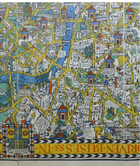
Figura 2 MacDonald Gill, Wonderground Map of London Town, detail, 1914. Photo © Caroline M. Walker
Driven by the Johnstons’ and Walker’s commitment, a number of significant events helped to promote research, publication and dissemination of Max Gill’s life and work and the contexts in which he worked. These included the creation of a MacDonald Gill website, the holding of an international symposium entitled “Out of the Shadows: A MacDonald (‘Max’) Gill Symposium” organised in conjunction with the opening of a complementary “Out of the Shadows” exhibition at the University of Brighton in 2011, followed by a number of other dedicated exhibitions including one at Pitzhanger Manor, Ealing in 2013 and ’Maps to Memorials – Discovering the Work of MacDonald Gill’ at the Lettering Arts Centre at Snape Maltings in 2014 through to the ‘Max Gill: Wonderground Man’ exhibition mounted at Ditchling Museum of Art + Craft held in 2018/2019 [Figure 2]. Furthermore Max Gill’s pictorial maps, small and large scale, are included in many important national collections in Britain, including those of the British Library, the National Archives, the London Transport Museum, and the Victoria & Albert Museum, London.
2 The Cunard ocean liner RMS Queen Mary: a background
to the decorative schemes and design commissions
For the purposes of this article Max Gill’s role in the production of the large mural painting of the North Atlantic Map for the First Class Dining Saloon of the ‘No 534’ (as the Queen Mary was originally known) is of paramount interest [Figure 3]. However, there a number of significant supporting actors in this story, foremost amongst them being American Benjamin Wistar Morris (1870-1944) who was the principal architect of the major public rooms and spaces on board the ocean liner. Having received an architectural training at Columbia University in the USA and the École des Beaux-Arts in Paris he was well placed to understand the cultural predilection of both European and American passengers. In order to oversee the complex, custom-designed interiors, furniture, fixtures, fittings and decorations a design committee was established, giving Morris responsibilities for the artistic commissioning of artists, designers and manufacturing firms.
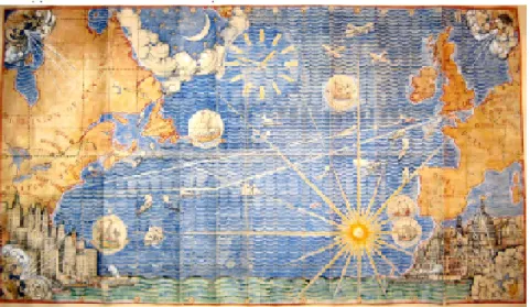
Figura 3 MacDonald Gill, Map of the North Atlantic (for RMS Queen Mary) original artwork, 1935. Photo ©
Caroline M. Walker (by permission of Estate of MacDonald Gill)
Also important were École des Beaux-Arts trained Arthur J Davis and Charles Mewès, partners in the prominent London-based architectural and design practice (established 1900). Frenchman Mewès had already been instrumental in bringing a shift in the experience and expectations of ocean liner passengers on the upper decks. The main attraction of ocean liners was transformed from being viewed principally as a means of transportation to becoming more closely associated with the more sensual, evocative and leisurely experience of a floating hotel. Mewès had worked closely with Albert Ballin, Director of the Hamburg America shipping line who, in 1905, had commissioned a luxury restaurant and interior spaces for the Amerika liner that became highly influential over the following decades. Many commissions for well-known buildings and interiors for leisure had followed the establishment of the Mewès and Davies partnership, including The Ritz Hotel (1906) and the Royal Automobile Club (1908-11), both in London. Although Mewès died in 1914, the Mewès & Davis partnership name lived on and the firm worked with Benjamin Morris on the commissioning of the Queen
Mary interiors, with Englishman Arthur Davis taking a key role.
Following the inspection of a model submitted by leading British furniture and decorating firm of Waring & Gillow (established 1903), preliminary schemes for the First Class Dining Saloon of the ‘No. 534’ (as the Queen Mary was originally known) were agreed by the Cunard Shipbuilding Committee as early as October 1930. Waring & Gillow had been formed from two well-established businesses, Gillow’s having already had considerable pedigree in the outfitting of luxury yachts and liners including Cunard’s Lusitania (1906), the Heliopolis (1907) and the City of Cairo (1915).
However, although the 1930 meeting of the Cunard Shipbuilding Committee had included artistic commissions for the Queen Mary as an agenda item, things were slow to move forwards over the next
year, as evidenced by a letter from Arthur Davis to E C Leach, the Superintendent of the Furnishing Department at Cunard’s Liverpool quarters, in which he wrote that:
“With regard to the paintings and other decorative features required by Artists I think perhaps the best solution would be for your directors and ourselves to decide what amounts should be allocated for each of these and make an offer to the various artists who are selected” (Cunard Archive, Liverpool, undated).
This was easier said than done, particularly at a time of
international economic uncertainty in which it was difficult to push major projects forward. In a Memorandum to the Chairman of the Shipbuilding Committee in February 1932, Leach disclosed that Arthur Davis had been holding discussions with artists who were considered suitable for commissions for work on the Queen Mary, as well us their suggested prices. The Committee considered that these were “felt generally to be far too high” with subsequent discussions between Davis and the artists leading to a lowering of prices. In the case of Max Gill this was quite substantial with the original proposal of £950 for his 5.8m x 3m large Map of the North Atlantic for the dining room being slashed to £500, much to Gill’s and his second wife Priscilla’s irritation. Discussions about payments were again presented to Cunard’s Shipbuilding Committee on 8 February 1932 and again deferred, a practice that continued until mid 1935.
Additionally, several wider artistic matters relating to the First Class Dining Saloon still remained unresolved in early October 1934 when an internal Cunard memorandum reported that:
“The success of this room will depend very largely on the pictures, which form part of the design. It is essential that these should be done by men who are in sympathy with the general scheme of decorations which has been adopted for the ship. Mr Davis has very definite ideas as to whom to approach and how. The matter ought to be put in hand without undue delay” (Cunard Archive, Sydney Jones Library, Memorandum of 8 October 1934: ‘Queen Mary’ Internal Decoration).
However, things began to move forward in Spring 1935 when Benjamin Morris, the principal architect responsible for the public rooms on the Queen Mary, arrived in Britain. With Cunard’s E C Leach he visited a number of the artists under consideration for the decorative work, several of whom he had also visited in February 1934. In a letter of 27 April 1935 to H J Flewitt, the Secretary of Cunard White Star Limited, Liverpool, Morris saw the selection of artists as “a pressing matter”. In a further letter to Flewitt of 14 May Morris also related how Kenneth Clark, Director of the National Gallery, London, had helped greatly in the nomination of artists and that “progress is well under way in this direction”. On the following day he also reported to Flewitt that, “subject to Mr Leach’s budget requirements and Committee action”, he had settled on the partial award of artists’ commissions. Those commissioned included Bloomsbury Group artist and designer Duncan Grant, sculptor Maurice Lambert, fine
artist Edward Wadsworth, muralist Doris G Winkelstein, and pictorial map and poster designer Macdonald Gill. Gill’s North Atlantic Map commissioned for the First Class Dining Saloon was enlarged by the Committee to 28 square meters, a very significant increase in size for which a payment of £850 would be made with an additional £170 “for Map Gear and fixing”. (£850 in the mid 1930s would be worth more than £60,000 in 2019). Contracts were swiftly set in place and approved by the Shipbuilding Committee on 3 June 1935.
From a more personal perspective this succession of events may be set against a number of contemporary entries relating to Max’s Queen
Mary map in Priscilla Johnston’s diaries that are in the Johnstons’
possession. In the early entries where the map is referred to, her initial concerns were largely financial, perhaps understandably in terms of ensuring the security of her personal relationship with Max, her significantly older partner. Prior to the later offer of £850 she had written how 27 February 1935 was “celebrated as Cunarder Day. We had a Cunarder cake for tea. We were excited – but only £500 – that isn’t enough”. But just over two months later on 25 May 1935 her entry reads: “Long letter from Max. Cunarder panel apparently is coming off - & 3 feet longer than it was to have been – for this they offer another £350!!! I don’t understand that. Surely this should make a difference to his finances!” On 19 June Priscilla and Max went to see Mr Grant of Waring & Gillow about the Cunard panel. This was for two reasons: firstly Waring & Gillow had won the commission for the
Figura 4 Painting the Map of the North Atlantic, left to right: Priscilla Johnston, William Kingswell,
total decorative work for the First Class Dining Saloon with a tender of £33,330.17s.10d; secondly, and more practically, Waring & Gillow’s “rather dreary” factory at Hammersmith, London, as Priscilla
described it, was to be the place where the Queen Mary map panel would be “given birth”. Perhaps revealing something of her social standing (and assumptions) she described the factory thus:
“Definitely uncongenial surroundings, but not impossible, & I thought surely they would feel it there, it would seem neither wonderful & precious to those workmen that such bright beauty should be flowing on that white ground – something growing, opening, flowering, in their rather drab factory. They would not think it, but I think they would feel it so. I see them coming in diffidently, shyly, wiping their hands on their trousers, peering round the door...” (Johnston, Diary entry for 28 June 1935).
In June the panels had been sent out to a factory in Willesdon, North London, to be drawn out in full size but it took a further six weeks for them to arrive at Waring & Gillow’s Hammersmith factory where Max was to work on it, supported by his assistant on many major commissions of the 1930s, artist William ‘Billy’ Kingswell, and Priscilla. In the meantime Priscilla was enraged by a meeting with Mr Whipp of Mewès and Davis on 28 August about which she fulminated thus on the pages of her diary:
“They now want the land black with vague brown clouds in between, to me it sounds quite hopeless. I feel it’s a mistake to do it like that anyway, but if they must have it like that Max is not the right man to do it. However Max seems quite happy about it & that is what matters, after all. I suppose that he can visualise it, which I certainly cannot. I, at any rate am very much disappointed & strongly opposed to the whole idea” (Johnston, Diary entry for 28 August 1935).
On 1 November Priscilla recorded that “the panel seems to be getting on so fast that I feel it will be no time before we finish it and that Max will have some hundreds of pounds in hand on his job – I think he’s bound to do fairly well over it.” There are a number of photographs of Max, Priscilla and Billy at work [Figure 4] taken by, as Priscilla put it, “the incredible little photographer from Essex Street” (29 November). Early in 1936 Max held a private view of the map panels following which, on 6 January, the panels were packed up and sent off to the John Brown & Company shipyard in Clydebank, Scotland, where the Queen Mary was being fitted out. Final work on the panels began on board the ship in the middle of January and, despite a number of glitches, was completed on 7 February 1936.
3 Gill’s North Atlantic Map in the First Class Dining
Saloon on the Queen Mary ocean liner
To return to the Cunard Queen Mary’s First Class Dining Saloon itself, the floor plan measured 36 meters by 55 metres and the space was designed to cater for 800 passengers to be served at a single sitting.
It was thought to be the largest public space ever built on an ocean liner and something of the scale can be gleaned from contemporary photographs. Nonetheless, Gill’s enormous North Atlantic Map Panel on the forward wall dominated the room [Figure 5]. Remarkable though it may seem, the North Atlantic Map has not attracted any particularly sophisticated analysis by art and design historians or researchers who have devoted themselves to the history of ocean liners and their interior design. The latter in particular have often followed common sources and repeated the same inaccuracies about several aspects of the Queen Mary. Very few have sought to address relevant primary sources, whether in terms of the substantial Cunard archives held at the Maritime Museum, Liverpool, those in the Special Collections and Archives in the University of Liverpool’s Stanley Jones Library, or those of contributing companies such as Waring & Gillow. However, although they too have not benefitted from examining such resources, many of the most interesting insights to the content of Gill’s Queen
Mary First Class Dining Saloon Map have been made by two urban
geographers, David Gilbert and Claire Hancock, in their absorbing article on “New York City and the Transatlantic Imagination: French and English Tourism and the Spectacle of the Modern Metropolis, 1893-1939” in the Journal of Urban History, November 2006.
One of the key features of Gilbert and Hancock’s work is their consideration of a range of dimensions of time, place and meaning in relation to transatlantic travel. These may be summed up in the authors’ deliberation over the contrasting representations of the Old and New Worlds in Max Gill’s portrayals of the towering skyscrapers and optimistic progress of New York City and the heritage-laden ethos of London as a metropolis steeped in history and tradition, as seen on the bottom left and bottom right of the Panel. For Gill the latter was characterised by enduring landmarks such as Nicholas Hawksmoor’s English Baroque churches of the early 18th century, Sir Christopher Wren’s St Paul’s Cathedral (1711), Augustus Pugin’s Big Ben (1858,
Figura 5 MacDonald Gill, Map of the North Atlantic, RMS Queen Mary, 1936. Photo © Caroline M. Walker.
the Clock Tower of the Houses of Parliament, now known as the Elizabeth Tower), and John F Bentley’s Westminster Cathedral
(1903). New York underwent considerable changes between the late 19th century and the 1930s both in terms of population and the cityscape as well as forging its place as an increasingly significant destination on the tourist map, facilitated by the considerable growth in steam-powered transatlantic sea travel for leisure as well as
practical purposes. No doubt stimulated by decades of immigration from Europe from the mid-19th century onwards, New York emerged alongside the leading capitals of Europe as a destination on the 20th century Grand Tour, sustained by the media of film, photography, travel writing and the shifting centre of gravity of the world economy. Aspects of this are addressed by what Gilbert and Hancock describe as “Tourist Knowledges and the ‘Baedekerization’ of New York City”. The image of New York conceived and Metropolis
of Tomorrow (1929), published two years later than Fritz Lang’s
rather more dystopian filmic vision of Metropolis, and by British artist Rudolf Sauter in his pastel, crayon and mixed media renditions of the skylines of many north American cities, including New York, which he had visited in the 1920s with his uncle, the English novelist and playwright John Galsworthy. Widely recognised also were the contemporary futuristic images and writings by American designer Norman Bel Geddes (1893-1958), most notably in his book Horizons (1932), elements of which were also disseminated in popular
magazines and also through the sets of the 1936 science fiction film
Things to Come on which he was consulted.
Contemporary documentary photographs from 1932 show the realities of the Manhattan cityscape and convey something of the startling vista that greeted transatlantic passengers on their arrival in New York. As the Special Correspondent of The Times (London) remarked in his/her “Round Tripper’s” account of the transatlantic voyage on board the Queen Mary on 11 June 1936:
“No one who sailed from England in the Queen Mary will ever forget her arrival in New York. The Wellsian Scene has been described in full –the swarm of aeroplanes, the assorted shoal of vessels, the strange phalanx of skyscrapers, the multitudes close-packed on every vantage point, the all-pervading din. The great ship caught hold of popular imagination to a fantastic extent” (The Times, 11 June 1936, p. 17).
The Cunard Archives in Liverpool contain quite a number of letters from members of the public and others to the Cunard Company offering advice about the informational requirements of passengers on transatlantic liners. Interestingly Frank Pick, who had been publicity manager for the Underground Electric Railways Company of London (UERC) in 1908 had coincidentally commissioned pictorial maps from Max Gill including his 1914 Wonderground Map of London Town, but went on in the 1930s to offer Cunard design advice. By the 1930s Pick was playing a key role in national design debates, having been appointed in December 1933 as the Director of the newly established state-funded Council for Art and Industry (CAI) and was, almost inevitably, involved a major, partly Government-funded national
design project, set of discussions about the role of British designers in the furnishing and decoration of the Queen Mary.
Pick’s contribution to discussions of passenger information needs on the Queen Mary was expressed in a characteristically lengthy letter to Sir Percy Bates, the Cunard Chairman, dated 14 November 1934. He wrote:
“Then by way of another toy, and that is what people want upon a ship, it may be possible to have the Atlantic routes laid out, with all the liners crossing the Atlantic placed upon them in model form, their positions being moved every 12 hours so that everyone on the ship could see the ships that were nearby or adjacent to them all the way over the Atlantic. The scale models which Bassett-Lowke⁴ makes would suit this purpose, and it only needs some sort of simple setting for them which would indicate the Atlantic routes. It could be set into the side of one of the walls as a kind of frieze and could be quite amusing”.⁵
What Pick didn’t appear to remember was Max Gill’s design from the previous decade for the Shell-Mex Kiosk at London’s Wembley Empire Exhibition of 1924-25, the latter attracting a total of 27 million visitors over the two-year seasonal openings. For this Gill had designed the Shell Map of the World, complete with moving vehicles. In 1936 his North Atlantic Map for the First Class Dining Saloon incorporated two tracks representing the winter and spring transatlantic crossing (the more southerly route to avoid icebergs) and the summer and autumn route. During every transatlantic crossing a mechanised crystal model of the Queen Mary would travel along these tracks to indicate the liner’s progress at every stage of the voyage. This had also been noted in The Times (London) in an article of 30 December 1935 on the “Interior of the Queen Mary: Works by Famous Artists” whilst Gilbert and Hancock were able to give it a 21st century spin, seeing a parallel to this key feature as an anticipation of global positioning systems found on the backs of aircrafts seats today.
One last matter that Gilbert and Hancock touched upon in their reading of Max Gill’s North Atlantic Map was their emphasis on the top of the Map Panel to the right of the clock where two biplanes are flying without any particular sense of purpose, a seeming indication that Cunard was confident that transatlantic flight would never replace the lavish 1930s generation of ocean liners as the principal means of transatlantic travel. However, contained in the University of Liverpool’s Cunard-related archives are the papers of economic historian Professor Francis E Hyde and author of the somewhat neglected text on Cunard and the North Atlantic 1840-1973 (1975) which make it clear that such an outlook was already at some remove from the realities of the competitive transatlantic travel business of the period. By the time of the Queen Mary’s inaugural voyage in 1936 there had in fact been considerable discussion about the development of transatlantic air traffic routes. Only eight years after Charles Lindbergh’s heroic solo air crossing of the Atlantic in 1927, Henry Tate forwarded to the Cunard White Star Chairman Sir Percy 4 Basset Lowke was a toy
manufacturing company based in Northampton, England, specialising in scale models of trains and ship.
5 University of Liverpool
Archives – Cunard: D42/C3/1/6/93: Mr Pick.
Bates plans for developing an airline using large seaplanes with diesel engines, a theme further evidenced by the Cunard Papers file devoted to Cunard White Star and Transatlantic Air Services 1934-1936. Apart from potential implications for transatlantic ocean travel, one of the major concerns related to the lucrative transatlantic mail contract that was vested in shipping and so Bates corresponded closely with Sir Eric Geddes, Chairman of Imperial Airways, and also informed the Treasury. Nonetheless, the British Government entered into an agreement with Imperial Airways without the involvement of Cunard. Something of this was very much in the public realm, as was made clear in an article in The Times of 23 June 1936 entitled ‘Two Atlantic Crossings, The Queen Mary and the Hindenburg”. In it attention was drawn to the fact that the Queen Mary arrived in New York on 22 June, the journey lasting 4 days, 16 hours and 13 minutes at an average speed of 28.14 knots. The Hindenburg, a large German commercial passenger-carrying airship designed and built by the German Zeppelin Company had been making the third of ten experimental trips across the Atlantic Ocean arrived in Lakehurst Airfield, New Jersey, taking 59 hours and 50 minutes for the voyage from the Germany and averaging 85 knots. In a Report of 1937 the US Maritime Commission concluded that in the near future one-day aeroplane trips would be feasible alongside 2.5 day trips by dirigibles with a capacity for mail services. In fact Pan American Airlines had the northern transatlantic routes in its sights for several years, especially given the volume of passenger trade: in 1925 approximately one million passengers sailed the North Atlantic. Furthermore, the route had more first class passengers than any other steamship route – and thus more potential air passengers and in 1936 an agreement was signed between Imperial Airways and Pan American for exclusive landing rights in the USA and the UK with the proviso that neither airline could commence service until both had the capacity to fly the route. In May 1939 Pan American’s B-314 Yankee Clipper undertook the first transatlantic mail delivery from New York to Marseilles, via Lisbon and in June the Yankee Clipper made the first mail flight across the North Atlantic to England, with passenger services to Marseilles commencing in June (22 passengers). After the end of the Second World War the ‘golden age’ of ocean liner travel was to change irrevocably with the rise of increasingly swift and affordable air transport: Max Gill’s large scale mural North Atlantic Map in the First Class Dining Saloon of the Queen
Mary both epitomised the ‘golden age’ and hinted at the future of
transatlantic travel.
4 Conclusion
Max Gill’s mural of the North Atlantic Map was the visual highlight of the interior décor of an ocean liner that had been envisaged as a major international showcase for British art, design and the decorative
arts. It was a weapon in the battle for aesthetic, as well as engineering, supremacy over rival transatlantic ocean liner competitors from Germany, Italy, France and the United States. However, the Queen
Mary was only completed on the back of a £3 million Government
loan that enabled the lifting of the suspension of work in John Brown’s Clydebank shipyard in Glasgow in late 1931. Max Gill was one of more than forty artists, designers, interior decorators and manufacturers in what was planned as an ‘all British’ ship at a time of fierce international transatlantic travel competition by sea.
The North Atlantic Map mural was very different in feel from many of Gill’s earlier pictorial info-maps for such public bodies as the London Electric Railways as typified by the Wonderground Map
of London Town (1914) and Theatreland (1915); the Empire Marketing
Board as epitomised by the Highways of Empire Map (1927); and the General Post Office as represented by Mail Steamship Routes (1937). All of these maps had particular and individual ways of conveying often quite detailed information in a highly intelligible way. Informing the general public was an important dimension of all of the above examples, whether in helping London commuters at underground stations or on underground trains to learn more about the districts that they travelled to or through, to understand the significance of British Empire, its geographical disposition and world-wide trading mechanisms, or the various global imperial communication systems whether through maps of mail steamship routes, radio telephone services, and wireless systems. Gill’s North Atlantic Map for the Queen
Mary was a little different in nature: it was part of a commercial
enterprise through its provision of a luxury setting for first-class transatlantic ocean liner passengers. Nonetheless, in its individual way Gill’s map was also a conveyor of information and meaning, both symbolic and practical, as has been shown above, whether in terms of the artistic achievement of a key figure in pictorial map-making before the Second World War, part of a wider visual projection of the excellence of British art and design in the competitiveness in the international marketplace of transatlantic trade, an exploration of the visual contrasts of the old and new worlds and new tourist markets, or a moving miniature ship that kept passengers aware of exactly where they were in the Atlantic Ocean at any given time on their voyage.
References
Archives
Cunard Archive, Sydney Jones Library, University of Liverpool, England. National Archives, Kew, London, England.
Photographic Archives, Liverpool Maritime Museum, England. Picture Library, National Maritime Museum, Greenwich, England.
Macdonald Gill official website. http://www.macdonaldgill.com/
Macdonald (‘Max’) Gill Project website. http://arts.brighton.ac.uk/projects/ macdonald-gill
Walker, C & Johnston, A. (2016). The life and legacy of MacDonald Gill. Retrieved from https://www.bl.uk/maps/articles/the-life-and-legacy-of-macdonald-gill
Bibliography
Bel Geddes, N. (1977). Horizons. New York, NY: Dover Publications. Originally published 1932, Boston: Littlebrown & Co.
Brinnin, J. M. (1971). The sway of the grand saloon: A social history of the North Atlantic, New York: Delacorte Press.
Constantine, S. 1986. Buy & build: the advertising posters of the Empire Marketing Board. London: H.M.S.O./ Public Record Office.
Dobbin, C. 2012. London underground maps – art, design and cartography. London: Lund Humphries.
Dodman, F E. (1955). Ships of the Cunard line. London: Harrap.
Ferris, Hugh. (2005). Metropolis of tomorrow. New York: Dover Publications. Originally published 1929, New York: Ives Washburn.
Gilbert, D. & Hancock, C. (2006). New York City and the transatlantic imagination: French and English tourism and the spectacle of the modern metropolis, 1893-1939. Journal of Urban History (November): 77-107. Hinkey, D. M. (1994). The art of the RMS Queen Mary. Long Beach, CA:
Hippodrome Galleries.
Hyde, F E. (1975). Cunard and the North Atlantic, 1840-1973. London: Macmillan. Johnston, P. (nd). Diary. Unpublished: Estate of MacDonald Gill.
McCutcheon, J. (2000). RMS Queen Mary: Transatlantic masterpiece. Stroud, UK: Tempus Publishing.
Steele, J. (2001). Queen Mary. London: Phaidon.
Weallens, A. (2006). Designing liners: A history of interior design afloat. London: Routledge.
Author:
Jonathan M Woodham
j.m.woodham@brighton.ac.uk Centre for Design History University of Brighton
Paper submitted 0n 11/04/2019 Approved on 29/07/2019