Spatial data and modelling for the prioritisation of conservation areas
in the Alpine region of the Canton of Vaud
Ana Rute Pires Cardoso
Dissertação de Mestrado em
Ordenamento do Território e Sistemas de Informação Geográfica
Dissertação apresentada para cumprimento dos requisitos necessários à obtenção do grau
de Mestre em Ordenamento do Território e Sistemas de Informação Geográfica, realizada
sob a orientação científica do Professor Rui Pedro Julião e do Professor Antoine Guisan
Trabalho de dissertação desenvolvido no
Acknowledgements
To Professor Rui Pedro Julião, for his supervision and the encouragement to pursue my interests
To Professor Antoine Guisan, for suggesting the topic, for his supervision, and for receiving me in his group at UNIL and providing the conditions and data for this work
To the entire ECOSPAT group, for making me feel welcome and answering all my questions, and especially to Rui Fernandes who has tirelessly helped me along the way and reviewed this thesis
To Ba, for the amazing review and endless patience while trying to teach me grammar To my parents, for supporting yet another Masters adventure
SPATIAL DATA AND MODELLING FOR THE PRIORITISATION OF CONSERVATION AREAS IN THE ALPINE REGION OF THE CANTON OF VAUD
ANA RUTE PIRES CARDOSO
ABSTRACT
Increasing awareness of the impact of biodiversity loss and natural system instability on human life is changing the societal perception of the environment and the amount of effort put into solving environmental problems.
In spatial planning, this translates into a quest for the sustainable use of the territory, allocating areas to their most suitable usage while managing conflicting interests and forces. Conservation areas are the cornerstone of any spatial strategy for nature conservation, but are strongly affected by socio-economic constraints that affect their implementation and maintenance. Prioritising interventions thus becomes fundamental to achieve efficient and effective results.
Conservation planning has come a long way since its infancy, gradually putting aside traditional ad hoc reserve selection in favour of a more scientific and systematic approach. This development has been supported by advances in technology, especially in the area of geographic information systems, which allow for improved acquisition and faster treatment of spatial data. Modelling has also became a fundamental scientific activity for conservation planning, offering a better understanding of natural and biological phenomena and generating indispensable data used in emerging conservation planning support software.
This dissertation looks at methods for the selection of high-quality areas for conservation, focusing on the maximum cover problem and analysing how traditional strategies translate into spatial differences on the resulting selection.
The study area chosen to test our methodology is the Alpine region of the Canton of Vaud, in Switzerland, an area known for its biodiversity and cultural richness. After a thorough analysis of the area, focused on the biodiversity, socio-economic, political, and legal aspects that affect conservation planning, we decided to concentrate on prioritisation for vegetation conservation.
In the end, there are no perfect or universal solution for conservation planning prioritisation: different spatial translations can yield similar results for biodiversity. The process is an exercise in trade-offs in which software like Zonation can be of great assistance, allowing for an easier assessment of different scenarios and conservation strategies.
DADOS ESPACIAIS E MODELAÇÃO PARA A PRIORIZAÇÃO DE ÁREAS DE CONSERVAÇÃO NA REGIÃO ALPINA DO CANTÃO DE VAUD
ANA RUTE PIRES CARDOSO
RESUMO
A crescente consciencialização das repercussões da perda de biodiversidade e da disrupção dos sistemas naturais na vida humana tem modificado a percepção dos problemas ambientais e fomentado a mobilização de recursos para os resolver.
Em ordenamento do território, esta preocupação traduz-se na procura de uma ocupação sustentável do espaço, tentando gerir forças e interesses muitas vezes opostos e dificilmente conciliáveis. As áreas protegidas são os alicerces de qualquer estratégia para a conservação ao nível territorial, mas a sua implementação e manutenção é fortemente influenciada por limitações contextuais de origem socioeconómica. Priorizar intervenções e investimentos em conservação de forma a torná-la mais eficaz e eficiente torna-se, assim, essencial.
A planificação para a conservação ambiental e o método de selecção de reservas por esta empregado têm sido alvo de desenvolvimentos nas últimas décadas, passando de uma abordagem pouco científica a um processo sistemático. Esta mudança de paradigma só foi possível devido ao desenvolvimento paralelo de tecnologias de informação geográfica que vieram possibilitar uma melhor e mais rápida aquisição de dados espaciais e seu tratamento. A modelação tornou-se uma ferramenta científica indispensável no processo de planeamento, permitindo a recolha de informação sobre fenómenos naturais e de dados indispensáveis para a utilização de software de ajuda à decisão.
Esta dissertação pretende estudar os métodos empregues na identificação e selecção de áreas a proteger, focando-se no problema da máxima representatividade e na análise de estratégias comuns de priorização na tradução espacial dessa selecção.
A área de estudo escolhida para esta análise foi a zona alpina do Cantão de Vaud, na Suíça, uma área conhecida pela sua biodiversidade e riqueza cultural. Depois de uma análise detalhada às características de biodiversidade, socioeconómicas e político-legais locais, decidimos concentrar o nosso estudo na preservação da vegetação.
Recorrendo ao programa de apoio à decisão em planeamento de conservação Zonation v4, analisámos as diferenças espaciais resultantes de diferentes opções de conservação e dados de entrada, tais como a preferência pela salvaguarda da raridade ou da riqueza biológica, a atribuição de diferentes pesos às espécies com base em critérios vários ou a inclusão de informação socioeconómica. Tentámos ainda apurar a lógica subjacente à criação das reservas existentes e identificar possibilidades de expansão que beneficiariam a conservação.
expansão futura. Os resultados revelam ainda que as reservas actuais têm boa cobertura e um aumento de 2% da área seria suficiente para atingir uma representação quase total das espécies consideradas. É possível encontrar soluções interessantes sem comprometer de forma marcante a salvaguarda da biodiversidade.
Em planeamento de conservação, não existem soluções perfeitas e universais, tratando-se antes de um constante exercício de concessões. Programas de ajuda à decisão em planeamento de conservação, como o Zonation v4, demonstram grande potencial, permitindo uma melhor compreensão das alternativas e a sua rápida visualização espacial.
Table of Contents
Acknowledgements Abstract
Resumo
Table of Contents List of Figures List of Tables List of Acronyms
1 Introduction ... 1
1.1 Theme ... 1
1.2 Goals and objectives ... 2
1.3 Structure ... 4
2 Spatial Planning and Conservation Planning ... 5
2.1 Defining spatial planning and conservation planning ... 5
2.2 History of planning and conservation ... 8
2.3 Main actors and forces in conservation planning ... 13
2.4 Threats and costs in conservation planning ... 16
2.5 Goals and targets in conservation planning ... 20
2.6 Evolution of methods for reserve selection ... 22
3 Geographical Information Systems in Biodiversity Conservation ... 27
3.1 Geographical information systems in conservation ... 27
3.2 Species data and species distribution models ... 29
3.3 Programs and algorithms for reserve selection ... 32
3.4 Error, uncertainty, and bias ... 38
4 Methodology ... 43
5.1 Geographical framing ... 51
5.2 Policy and legislation ... 52
5.2.1 Political system ... 52
5.2.2 Environmental and spatial legislation ... 55
5.2.3 Protected areas ... 57
5.2.4 National conservation goals ... 61
5.3 Socio-economics ... 63
5.3.1 Characterisation, land use, and land value ... 63
5.4 Biodiversity ... 65
5.4.1 Presence-absence data ... 65
5.4.2 Species distribution models and habitat suitability maps ... 66
6 Results and Discussion ... 69
6.1 Rarity versus richness and species weighting using biodiversity ... 69
6.2 Socio-economic data in the prioritisation process ... 74
6.3 Comparing and expanding protected areas ... 80
6.4 Zonation v4 perspectives ... 84
7 Conclusion ... 87
References ... 91
Appendix 1: Aichi Biodiversity Targets (CBD Secretariat, 2015) ... i
Appendix 2: Eleven-stage systematic conservation planning framework (Robert L. Pressey & Bottrill, 2008) ... v
Appendix 3: List of species with habitat suitability maps and their national Red List classification and legal status ...ix
Appendix 4: List of species of special interest (SSI) with presence-absence data and their national Red List classification and legal status ... xv
List of Figures
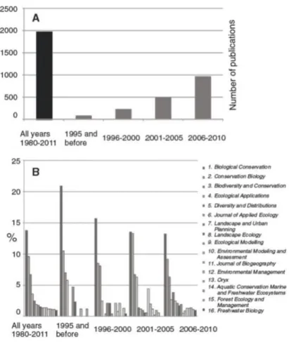
Figure 1: Evolution of the number of scientific publications in systematic conservation planning (SCP) and distribution by the sixteen journals in which they most often appear
(Kukkala & Moilanen, 2013) ... 3
Figure 2: Global protected area network ... 12
Figure 3: Regress and divestment in conservation around the world (Watson et al., 2014) .. 13
Figure 4: Dynamic of primary forces affecting conservation planning ... 14
Figure 5: Primary threats to biodiversity (McLellan, 2014) ... 17
Figure 6: Criteria used for IUCN Red List categorisation (IUCN, 2015) ... 21
Figure 7: IUCN Red List categories (IUCN, 2015) ... 21
Figure 8: Steps of the ecological niche modelling process (Peterson et al., 2011) ... 30
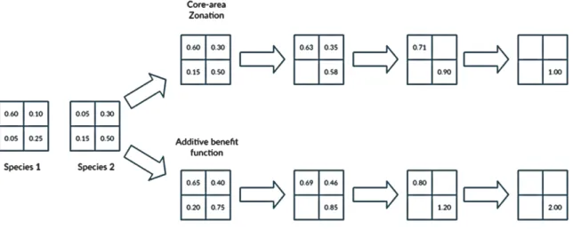
Figure 9: Zonation target-based function (Moilanen et al., 2014) ... 36
Figure 10: Generalised benefit function shapes (Moilanen et al., 2014) ... 36
Figure 11: Cell remover in action: CAZ vs ABF (Loyola, 2013) ... 37
Figure 12: Methodology diagram ... 43
Figure 13: Input data methodology ... 45
Figure 14: Terrain acquisition cost methodology ... 46
Figure 15: Political cost methodology ... 47
Figure 16: Study area in the context of Switzerland ... 51
Figure 17: Study area detail ... 51
Figure 18: Cantonal results from the popular vote on the initiative “Pour en finir avec les construction envahissantes des résidences secondaires” (Canton de Vaud, 2015) ... 54
Figure 19: Cantonal results from the popular vote on the counter-initiative to “Sauver Lavaux” (Canton de Vaud, 2015) ... 54
Figure 20: Potential political cost for conservation ... 55
Figure 21: Protected areas under programs for biodiversity (Office Fédéral de Topographie Swisstopo, 2015) ... 58
Figure 22: All protected areas (Office Fédéral de Topographie Swisstopo, 2015) ... 58
Figure 23: Protected area tiers ... 59
Figure 26: Estimated land acquisition cost in Swiss Francs per cell ... 64 Figure 27: Conservation status of SSIs ... 66 Figure 28: CAZ with biodiversity features and ethical weighting where weight=1 for all species (scenario AA1) ... 71 Figure 29: ABF with biodiversity features and ethical weighting where weight=1 for all species (scenario AA2) ... 71 Figure 30: CAZ with biodiversity features and National Red List weighting where LC/NE/DD=1, NT=2, VU=3, EN=4, CR=5, and RE=6 (scenario AB1) ... 71 Figure 31: ABF with biodiversity features and National Red List weighting where LC/NE/DD=1, NT=2, VU=3, EN=4, CR=5, and RE=6 (scenario AB2) ... 71 Figure 32: CAZ with biodiversity features and legal status weighting where protected=3, not protected=1 (scenario AC1) ... 72 Figure 33: ABF with biodiversity features and legal status weighting where protected=3, not protected=1 (scenario AC2) ... 72 Figure 34: CAZ with biodiversity features and National Red list weighting with a 2-point bonus if also legally protected (scenario AD1) ... 72 Figure 35: ABF with biodiversity features and National Red list weighting with a 2-point bonus if also legally protected (scenario AD2) ... 72 Figure 36: Proportion of distribution remaining for the six randomly chosen species at 80%, 90%, and 95% landscape lost in CAZ with biodiversity features and ethical weighting where weight=1 for all species (scenario AA1) ... 73 Figure 37: Proportion of distribution remaining for the six randomly chosen species at 80%, 90%, and 95% landscape lost in ABF with biodiversity features and ethical weighting where weight=1 for all species (scenario AA2) ... 73 Figure 38: Combination of the 25% best-ranked landscape using CAZ and ABF and the 4th
weighting strategy (scenarios AD1 and AD2) ... 74 Figure 39: CAZ with the 4th weighting strategy and a mask to exclude urban areas (scenario
BA1) ... 76 Figure 40: ABF with the 4th weighting strategy and a mask to exclude urban areas (scenario
BA2) ... 76 Figure 41: CAZ with the 4th weighting strategy and a mask to exclude urban areas, accounting
Figure 42: ABF with the 4th weighting strategy and a mask to exclude urban areas, accounting
for estimated acquisition cost (scenario BB2) ... 76 Figure 43: CAZ with the 4th weighting strategy and a mask to exclude urban areas, accounting
for estimated political cost (scenario BC1) ... 77 Figure 44: ABF with the 4th weighting strategy and a mask to exclude urban areas, accounting
for estimated political cost (scenario BC2) ... 77 Figure 45: CAZ with the 4th weighting strategy and a mask to exclude urban areas, accounting
for both acquisition and political costs (scenario BD1) ... 77 Figure 46: ABF with the 4th weighting strategy and a mask to exclude urban areas, accounting
for both acquisition and political costs (scenario BD2) ... 77 Figure 47: Proportion of distribution remaining for the six randomly chosen species at 80%, 90%, and 95% landscape lost in CAZ with the 4th weighting strategy and a mask to exclude
urban areas (scenario BA1) ... 78 Figure 48: Proportion of distribution remaining for the six randomly chosen species at 80%, 90%, and 95% landscape lost in ABF with the 4th weighting strategy and a mask to exclude
urban areas (scenario BA2) ... 78 Figure 49: Proportion of distribution remaining for the six randomly chosen species at 80%, 90%, and 95% landscape lost in CAZ with the 4th weighting strategy and a mask to exclude
urban areas, accounting for both acquisition and political costs (scenario BD1)... 78 Figure 50: Proportion of distribution remaining for the six randomly chosen species at 80%, 90%, and 95% landscape lost in ABF with the 4th weighting strategy and a mask to exclude
urban areas, accounting for both acquisition and political costs (scenario BD2)... 78 Figure 51: Proportion of distribution remaining for the six randomly chosen species at 80%, 90%, and 95% landscape lost in CAZ with the 4th weighting strategy and a mask to exclude
urban areas, accounting for estimated political cost (scenario BC1) ... 79 Figure 52: Proportion of distribution remaining for the six randomly chosen species at 80%, 90%, and 95% landscape lost in ABF with the 4th weighting strategy and a mask to exclude
urban areas, accounting for estimated political cost (scenario BC2) ... 79 Figure 53: Combination of the 25% best-ranked landscape using CAZ and ABF and the 4th
Figure 54: Overlap of direct protected areas with the combination of the 25% best-ranked landscape using CAZ and ABF and the 4th weighting strategy (scenarios AD1 and AD2) ... 81
Figure 55: Overlap of direct protected areas with the combination of the 25% best-ranked landscape using CAZ and ABF and the 4th weighting strategy, with a mask to exclude urban
areas and accounting for both acquisition and political costs (scenarios BD1 and BD2) ... 81 Figure 56: CAZ with the 4th weighting strategy and a mask to exclude urban areas and block
protected areas according to their weight, accounting for acquisition and political costs (scenario C1) ... 82 Figure 57: ABF with the 4th weighting strategy and a mask to exclude urban areas and block
protected areas according to their weight, accounting for acquisition and political costs (scenario C2) ... 82 Figure 58: Proportion of distribution remaining for the six randomly chosen species at 80%, 90%, and 95% landscape lost in CAZ with the 4th weighting strategy and a mask to exclude
urban areas and block protected areas according to their weight, accounting for acquisition and political costs (scenario C1) ... 83 Figure 59: Proportion of distribution remaining for the six randomly chosen species at 80%, 90%, and 95% landscape lost in CAZ with the 4th weighting strategy and a mask to exclude
List of Tables
Table 1: IUCN Protected Area Management Categories (IUCN, 2008) ... 24
Table 2: First systematic conservation planning framework (Margules & Pressey, 2000) ... 25
Table 3: Fourteen-stage conservation planning framework (Sarkar & Frank, 2012) ... 26
Table 4: Generalised benefit function parameters (Moilanen et al., 2014) ... 36
Table 5: Zonation v4 aggregation methods (Moilanen et al., 2014) ... 38
Table 6: Zonation computation scenarios and parameters ... 48
Table 7: Summary of legal bases relevant to conservation planning in our study area ... 56
Table 8: Info-gap analysis parameterisation ... 61
Table 9: Strategic goals of the Swiss Biodiversity Strategy (Wiedmer & Wisler, 2014)... 62
List of Acronyms
ABF additive benefit function
ANN artificial neural network
BQP boundary quality penalty
CAZ core-area Zonation
CR critically endangered
DD data deficient
DET occupancy-determination
EN endangered
ENFA ecological niche factor analysis
ENM ecological niche model
EU European Union
GAM generalised additive model
GBM generalised boosted model
GIS geographical information systems
GLM generalised linear model
IUCN International Union for Conservation of Nature
LC least concern
MPA marine protected area
NE not evaluated
NGO non-governmental organisation
NT near threatened
PA presence-absence
PB presence-background
PO presence-only
RE regionally extinct
SCP systematic conservation planning
SDM species distribution model
SSI species of special interest
1
1
Introduction
1.1
Theme
The drastic loss of biodiversity is a worldwide recognised problem, not only resulting in the loss of important ecological values but also negatively affecting economic and social development.
Biodiversity is essential for human survival. It is estimated that 40% of the global economy and 80% of the sustenance of poor people is directly dependent on biological resources (Organisation for Economic Co-operation and Development, 2004), be it in the form of food, fuel, and medicine supplies, or of the environmental services they provide, which are frequently overlooked.
Meanwhile, the Global Living Planet Index has shown a decline of 52% in vertebrate population over the last 40 years, during the period between 1970 and 2010 (McLellan, 2014). Experts are suggesting that at the actual extinction rates — between 1000 to 10 000 times higher than natural (IUCN, 2007) — one-fourth of plants and vertebrate animals may be heading towards extinction by mid-century (Malcolm, Liu, Neilson, Hansen, & Hannah, 2006). Not surprisingly, the causes of this quick biodiversity decline are known to be closely related to human activity and its appropriation of territorial space and resources. Habitat destruction and degradation, over-exploitation of resources, pollution, diseases, alien species, and climate change are the main threats faced by biodiversity (IUCN, 2007).
The development of a widespread environmental conscience during the 20th century,
generated by the growing awareness of the importance of biodiversity and the increasing impact of the disruption of natural systems on human life, has brought conservation planning to the order of the day (Ministério do Ambiente e do Ordenamento do Território, 2001).
2
In a time of strategic spatial planning, based on principles of collaborative decision and the pursuit of territorial resilience, the need to understand the functioning of the territory and the complex systems that integrate it becomes fundamental.
Spatial information and spatial modelling, greatly boosted by the developments seen in geographical information systems (GIS) in the last few decades, became essential tools for informed, scientifically validated, technically supported spatial decisions.
That validation is particularly important in the environmental conservation domain, which more often than not faces opposition from economic entities and local populations that see the creation of protected areas and reserves as restrictive and detrimental for their way of life (Margules & Pressey, 2000).
This dissertation looks at methods for selecting high-quality areas for conservation. We focus our study in the Alpine region of the Canton of Vaud, a region marked by a long human occupation and a recognised richness of natural values. These natural values are under strong pressure and measures are needed to preserve them for future generations.
Nonetheless, like in most places around the world, it is not always possible to completely reconcile human interests and the protection of every species and habitat; establishing conservation goals and identifying priority areas for conservation becomes an unavoidable task.
1.2
Goals and objectives
Over the last few decades, the scientific work done in conservation planning has been steadily increasing, propelled by the growing recognition of its importance and by advances in diverse areas of knowledge.
This work has been mainly led by biologists and biogeographers and, even though they achieved interesting and scientifically validated results, we continue to see a gap between their research and real-world conservation planning. The field of spatial planning has given surprisingly few contributions to the subject (A. T. Knight et al., 2008) (Kukkala & Moilanen, 2013).
3
It is clear that there is a need to bring both areas together under the common interest that they share in sustainable territorial planning, as well as a need to promote opportunities to share data and experience and to improve communication in order to achieve better results in ecological preservation.
Figure 1: Evolution of the number of scientific publications in systematic conservation planning (SCP) and distribution by the sixteen journals in which they most often appear (Kukkala & Moilanen, 2013)
This dissertation, carried out in the framework of the Masters in Spatial Planning and Geographical Information Systems at Universidade NOVA de Lisboa and developed in the Spatial Ecology Group at the University of Lausanne, aims to contribute to a better integration of species distribution data with traditional spatial planning concerns such as legislation, culture, and economics in the scope of prioritisation in conservation planning.
The area of study chosen for this work is the Alpine region of the Canton of Vaud, which is the target of a new transdisciplinary research platform project (RechAlp1) that aggregates
diverse information, mainly in the natural sciences. We make use of existing high quality data
4
regarding species distribution gathered and created by the Spatial Ecology Group, with a main focus on vegetation, as well as other socio-economic data relevant for effective conservation planning.
Using Zonation v4 to solve the maximum cover problem, we developed a methodology that aims to:
identify priority areas for conservation taking into account different objectives and goals
evaluate in which way the different objectives and goals affect the use of data and the results of the prioritisation
analyse the current protected areas in the face of different prioritisation strategies
identify pros and cons of the current systematic conservation planning approach and the use of decision support software
1.3
Structure
5
2
Spatial Planning and Conservation Planning
2.1
Defining spatial planning and conservation planning
Planning and prioritising are two terms that often come together. The first, planning, is the act of making plans, of thinking about a task, determining goals, and defining the means to achieve them; it is intrinsically linked to predicting and preparing for multiple scenarios with which we might be confronted in the future. The second, prioritising, is the act of arranging and establishing an order of importance, of attributing weights of significance for doing the right task at the right moment, and of ensuring that a plan makes the best use of normally limited resources.
Both concepts have been appropriated by many fields of study, particularly those that deal with high complex issues and widespread conflicts of interest. One such field is the management and organisation of territorial space and of the human activities that take place within, commonly referred to as spatial planning.
Although interest in spatial planning is not new, the name by which it is best known nowadays is relatively recent. According to (Williams, 1996), spatial planning is a term developed in the course of shaping a European position in the field of planning and spatial development, derived from the need to find a neutral term not directly connected with the actual planning system of any of the European Union (EU) member states. Williams calls it a
Euroenglish word, due to its non-British origin, having resulted from the translation of the German Raumplanung and the Dutch Ruimtelijk.
6
development of his personality in surroundings planned on a human scale”. Moreover, it points at the need for harmonisation between the different interests at play in the territory, essential to achieve the spatial planning objectives of balanced socio-economic development of the regions, improvement of quality of life, rational use of land, and responsible management of natural resources and protection of the environment. According to the Charter, spatial planning should be:
Democratic: it should be conducted in such a way as to ensure the participation of the
people concerned and their political representatives;
Comprehensive: it should ensure the co-ordination of the various sectoral policies and
integrate them in an overall approach;
Functional: it needs to take account of the existence of regional consciousness based on
common values, culture and interests sometimes crossing administrative and territorial
boundaries, while taking account of the institutional arrangements of the different
countries;
Long-term oriented: it should analyse and take into consideration the long-term trends
and developments of economic, social, cultural, ecological and environmental
phenomena and interventions.
A complementary definition is given later in the EU Compendium of Spatial Planning Systems and Policies (European Commission, 1997) which states that: “Spatial planning refers to the methods used largely by the public sector to influence the future distribution of activities in space. It is undertaken with the aims of creating a more rational territorial organisation of land uses and the linkages between them, to balance demands for development with the need to protect the environment, and to achieve social and economic objectives.”
7
Spatial planning is, in the end, a broad term that intends to comprise the entire science or discipline dealing with territorial organisation strategies and development goals, ultimately helping to foster dialogue between different traditions of spatial organisation and development. The term may have had its origins in the EU but, owing to the globally recognised importance of the territory in sustainable development and socio-economic cohesion, it is now used worldwide.
The phenomenon of urban growth, translated not only into urban densification but also into urban sprawl, together with the trend for monocultures in both agricultural and forestry production, resulted in a clash of interests that is difficult to manage and showed that environmental and cultural values are particularly vulnerable and in need of special attention.
The term conservation planning refers to planning with the intent of preservation — in other words, to the idea of wise use; it is ultimately an exercise on setting priorities, due to the infeasibility of applying conservation initiatives everywhere and simultaneously (Trombulak, 2010). Depending on the country and context where it is used, it may result in different definitions. There are two main trends when referring to conservation planning: the cultural line and the natural resources line.
In the United Kingdom, conservation planning is mainly employed in the field of heritage conservation: “At its very simplest, a Conservation Plan is a document which states why a place is significant and what policies there are to ensure that significance is retained. It is basically an archaeological and historical assessment of a building or site which has been taken one step further, so the understanding is translated into specific policies for caring for what is important about the site” (Clark, 1998).
On the other hand, the Natural Resources Conservation Service of the United States Department of Agriculture (United States Department of Agriculture, 2015) employs the term in regards to natural resources conservation: “A conservation plan is the record of decisions and supporting information for treatment of a unit of land meeting planning criteria for one or more identified natural resource concerns as a result of the planning process.”
8
This work focuses on natural resources conservation planning, mainly in biodiversity conservation. In particular, we look at conservation priorities in the face of resources constrains. We recognise conservation planning as being “concerned with societal activities to protect productive ecological systems, conserve native biological diversity and associated ecological and evolutionary processes, and maintain wild species of special interest. Conservation includes a diverse array of policy and management approaches (e.g., zoning, ex-situ and in-situ nature reserves, conservation easements, adaptive ecosystem management) and engages a wide range of disciplinary perspectives. Interdisciplinary research in systematic conservation planning is concerned with theory and techniques to improve the scientific basis of planning and the cost-effectiveness of conservation and management actions” (Halpern & Airamé, 2015)
2.2
History of planning and conservation
It is often thought that spatial planning and conservation are topics that only recently came together. In fact, that could not be further from the truth: there seems to be a long history of partnership and mutual development, strongly anchored in the evolution of the human perception of the world around us.
Although the majority of olden settlements might look too chaotic and organic for us to consider the existence of any form of spatial planning, studies have shown that they were everything but casuistically started, instead following a logic of proximity to resources, defence advantages, trade opportunities, shelter against natural hazards, and aspect benefits (Internet Geography, 2010). People lived in and of the land and, by observation, experience, and knowledge transmission, made use of it according to their needs and what they perceived would maximise their odds of surviving.
Organic growth was and continued to be the dominant system for a long time. However, where settlements began to densify, the need arose for some kind of concrete planning to support population development.
9
hierarchy of streets, but also wells and drainage systems (Davreu, 1978; Kipfer, 2000). The same concern has also been identified in Mesoamerica (Smith, 2005).
Nevertheless, it was defence that, throughout the Classic and Medieval periods, played the most significant role in planning, with the recognisable gridded and walled Roman settlements, and later the more organic-growing but also fortified cities of medieval Europe (Kostof, 1999).
It was also early in history that man started to set aside natural areas deemed worthy of protection. From Asia to Europe and Africa, this practice was intrinsically connected with religion, the sense of holiness and the divine rights attributed to nobility. Sacred groves and trees were revered, and grand patches of forest were restricted, only to be used as hunting grounds for those born into nobility (Kanowski, Gilmour, Margules, & Potter, 1999).
The Industrial Age marked a turning point for both planning and conservation. A new dynamic of social classes emerged, and new disciplines and technologies changed how people viewed the world, allowing them to travel faster and to explore new places and resources. A rural exodus occurred, with masses of people heading towards the cities, which quickly grew and became dense and disorganised, turning into atrocious spaces riddled with pollution, crime, and disease.
The 17th century witnessed the invention of the microscope and the subsequent
discovery of the cell, along with other substantial developments in the natural sciences. It also saw the birth of a new conscience of social sciences that originated with the utopic ideas of the Enlightenment. These innovations were of key relevance to the development of planning and conservation as we know it (Magalhães, 2001).
While the 18th century was marked by a growing awareness of social and
10
With the arrival of the 19th century, the planning paradigm began to shift, as theorists
got to work developing models to mitigate the consequences of the Industrial Age. The classic planning school, with origins in the utopic ideal city and developing alongside with sanitary movement (1800 — 1890), became particularly known for the garden city movement (Hall, 2014).
By the second half of the 19th century, social views had changed, and with them both
planning and conservation. Rational planning emerged, establishing itself as the planning model of modernism. This movement emphasised the improvement of the built environment and advocated the supremacy of function over form, the separation of functions, the flow of vehicular traffic, and the standardisation of housing units, while maintaining the hygienist principles from classic planning, which defended direct sunlight exposure and proximity to green spaces (Hall, 2014; Skroblies, 2003).
The rational plan issued from a restricted group of specialists that employed logic, rationality, and their scientific knowledge to obtain the perfect final plan (Skroblies, 2003). Rationalist planners believed a good project to be universal and fit to be deployed anywhere in the world.
In conservation, preservationist and conservationist ideas had developed building on three core principles: that human activity was damaging to the environment, that there was a civic duty to protect nature for future generations, and that scientific and empirical methods should be applied to carry out this duty (Stebbing, 1922).
As conservation principles began to be put into practice, national parks started to emerge, spearheaded by the Yellowstone National Park in the United States. Early legislation regarding conservation was published and the first nature conservation societies founded (Baeyens & Martínez, 2004; Haines, 1996; Stebbing, 1922). The term “conservation” started to be used not only as related to the preservation of forests, wildlife, parkland, wilderness, and watersheds but also to the management of natural resources such as timber, fish, game, topsoil, pastureland, and minerals (Baeyens & Martínez, 2004).
By the late 20th century, rational planning was in decline, and technocracy had
11
territory as a complex system, composed by human and natural systems alike, and rationality was revealing itself too rigid to adapt to a time of fast paced change.
In this context, a new paradigm emerged, based on the idea that planning must be strategic, collaborative and resilient. This new paradigm sees the territory as a complex system with inner strengths and shortcomings, affected by forces both from within and without, competing with other territories. It focuses on actions to achieve development goals and emphasises the need to involve stakeholders in creating adaptable spaces, capable of reinventing themselves (Saboya, 2008).
In 1987, the Brundtland Report (World Commission on Environment and Development, 1987) defined sustainable development as follows:
Sustainable development is development that meets the needs of the present without
compromising the ability of future generations to meet their own needs. It contains within it
two key concepts:
The concept of needs, in particular the essential needs of the world's poor, to which
overriding priority should be given; and
The idea of limitations imposed by the state of technology and social organization on the
environment's ability to meet present and future needs.
Spatial planning starts to be seen as fundamental for this sustainable development, aiming
for social-economic territorial cohesion and for the preservation of natural resources and
human heritage (European Commission, 1999).
At the same time, the reduction in biodiversity had assumed proportions never before seen by the human race, becoming a major concern among the population and bringing the subject to the political agenda, which resulted in increased production of environmental laws, hastening of natural reserve creation, and unprecedented international cooperation between countries (Ministério do Ambiente e do Ordenamento do Território, 2001).
12
In conservation, the need for implementation of comprehensive management measures throughout the landscape — as a complement to reserves and protected areas — has gained acceptance. Spatial planning started to incorporate green corridors and ecological networks, turning connectivity into the new paradigm of nature conservation in the 21st
century (European Centre for Nature Conservation, 2010).
Unfortunately, even though protected areas are still steadily increasing (Figure 2), setbacks are starting to arise. Political and popular opinion around the subject seems to be changing for the worse, stemming from global economic slowdown, population growth, and lack of expected conservation results in many protected areas (Watson, Dudley, Segan, & Hockings, 2014).
Figure 2: Global protected area network
As Figure 3 shows, we started experiencing some slackening and regress in environmental laws and a growing divestment in the maintenance of existing protected areas (Hannam, 2015; Mazza, 2015; Watson et al., 2014).
13
Figure 3: Regress and divestment in conservation around the world (Watson et al., 2014)
2.3
Main actors and forces in conservation planning
A multitude of interests affects the territory, creating a complex mesh of forces and actors that interact with and influence each other. The underlying actors are typically referred to as stakeholders and are composed by persons, groups, or institutions that have interests or can be affected by territorial decisions, actions, and policies.
Conservation planning stakeholder groups may be composed of scientists, planning technicians, affected individuals and communities, non-governmental groups like NGOs, or economic lobbying groups, governmental organisations, and government representatives.
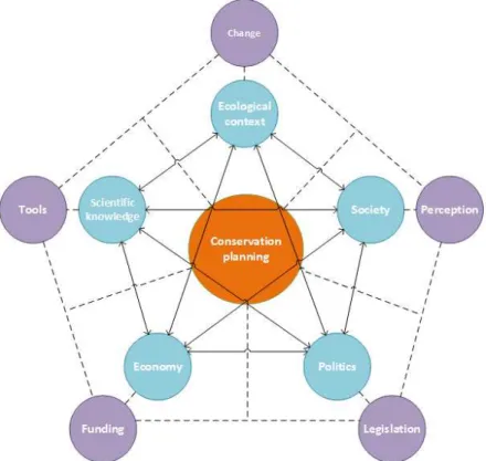
Simplistically, one may cite ecological context, scientific knowledge, society, politics, and economy as the primary forces that affect conservation planning (Bixler, 2013; Escobar, 1998; Tear et al., 2005), (Figure 4). We will briefly look at each of these forces in the remainder of this section.
14
The cumulative ecological context through time affects current conditions and resource availability — and with it all forms of life that inhabit the territory and their behaviour. In what concerns other species, it often manifests itself in the degrees of diversity, unicity, intrinsic resilience, and inter-species interaction. In humans, it is known to impact culture and values, the way we look at and interact with the world (Pretty et al., 2008; Wiens & Donoghue, 2004).
Figure 4: Dynamic of primary forces affecting conservation planning
Ecological context was often disregarded by humans, perceived as something constant and predictable, which is and always will be too big to fail or be affected by the human race. That perception has been progressively dispelled, with the ongoing destabilisation of natural systems becoming an increasing threat to human life and augmenting our awareness of the suffering of other species and of the need for action.
15
It is often argued that conservation objectives must be solely dependent on sound fundamental science, insulated from social, economic, and political pressure, pushing their place to merely goal revision or implementation (Tear et al., 2005). Meanwhile, decision makers tend to focus on the degree of uncertainty present in all scientific production (Bradshaw & Borchers, 2000). The way uncertainty is treated and explained to stakeholders is important to facilitate dialogue and transparency, and can help promote political decisions based on scientific knowledge while avoiding the politicisation of science (Bradshaw & Borchers, 2000; Pielke, 2004).
Society, and its perception of a subject, can be the driver of — or a major impediment to — conservation planning and its implementation. Appreciation for conservation is determined by both internal and external factors; among the most obvious, we find:
Cultural ethics: Moral values that dictate the way that a population interacts with other beings and the environment. For instance, according to Jainism, “all living things love their life, desire pleasure and are averse to pain; they dislike any injury to themselves; everybody is desirous of life and to every being, his own life is very dear”, leading its followers to adopt a vegetarian diet (Laidlaw, 1995).
Cultural affinity: Bonds established throughout history between culture and particular species. For instance, European folklore, religion, and mythology depict wolves as dangerous and dark creatures, which impairs support towards its conservation (Boitani, 2000).
“Cute factor” and aesthetics: Particular physical attributes possessed by species that cause certain reactions in people. For instance, a harp seal pup will have wider conservation support than a Dolloff cave spider (A. J. Knight, 2008).
Economic and utilitarian interest: Particular cultural approaches to the management of species that are indispensable or have the potential to bring additional value to the anthropic way of life. For instance, the opposition to lower fishing quotas for sardines in Portugal (Hagemann, 2015).
16
conservation planning processes, manages the distribution of funds towards conservation, and engages in the creation of environmental legislation that translates into concrete measures reflecting societal values (Czech, Krausman, & Borkhataria, 1998). Legislation becomes an important provider of binding tools that not only support conservation priorities but also help to mediate and regulate different competing activities and opposing interests that greatly affect conservation planning (McHenry, 1993).
Economy is often seen only as an opposing force to conservation planning owing to its association with economic interests that lobby against conservation measures related to resource exploitation. But conservation planning is not free, and funding, both public and private, is fundamental for the implementation and maintenance of conservation measures. Funding also allows for more complete and elaborate scientific research, more comprehensive measures of conservation, and improved resolution of conflict resulting in a more favourable attitude towards conservation (Naidoo et al., 2006).
All these forces interact and influence each other, both positively and negatively, and their equilibrium is permanently being affected by anthropic framing, forcing compromises and precluding a one-size-fits-all methodology or solution. Maslow's hierarchy of needs dictates that conservation is unlikely to be a concern for poor communities until their basic needs are met, and only by improving conditions for the communities can we ever hope to achieve conservation goals.
Conservation planning requires initiative, either public or private; unfortunately, more often than not, it only happens in response to a significant change in the ecological context and in the perception of an existing problem. For the efforts to be effective, tools are required: scientific tools that help make better decisions, legal tools that help manage conflicts and produce consistent policies, and both scientific and legal tools that put the previous measures into practice while ensuring population needs are met and support is maintained.
2.4
Threats and costs in conservation planning
17
The most significant anthropic sources of disturbances are well identified: pollution, habitat degradation/change, habitat loss, resource over-exploitation, diseases, alien species invasion, and, in an indirect way, climate change (Figure 5) (IUCN, 2007). As with the main forces affecting conservation, threats are intrinsically interconnected, mutually exacerbating the effects of one another in a downward spiral of negative feedback that impacts all species, including our own.
Figure 5: Primary threats to biodiversity (McLellan, 2014)
Conservation planning often aims to identify and diminish (or limit) the influence of these threats by trying to assess degrees of risk and imposing limitative measures on spatial use. In a world of limited resources, more and more relevance is given to the need to work around ecological problems and threats, keeping in mind a cost-benefit binominal.
There remains some controversy about what can be taken as a cost, especially when regarding immaterial concepts such as threats or political and societal trade-offs. Other types of cost, especially of the economic kind, are more notorious and consensual (Naidoo et al., 2006):
Acquisition costs: related to acquiring property or use rights over a parcel of territory, often volatile and in line with the market
Management costs: associated with the management of conservation, can be fixed operational costs or variable intervention costs
18
Damage costs: associated with reparations to economic activities that arise from conservation programs, such as attacks to livestock or damage to crops
Opportunity costs: associated with the loss of gains when compared to the next-best use
On the benefit side, studies are also focusing on the values of conservation and how they translate into economic terms. These benefits are denoted as ecosystem services and include provisioning, regulation, habitat support, and cultural amenities (de Groot, Alkemade, Braat, Hein, & Willemen, 2010).
Consensus on a coherent and integrated approach to ecosystem service assessment and valuation is still lacking, and most attempts are often admittedly undervalued. It is now widely recognised that nature conservation and conservation management strategies do not necessarily pose a trade-off between the environment and development, but can be complementary, generating ecological, social, and economic benefits (de Groot et al., 2010).
Beside the threats to biodiversity and ecosystems, we must also consider the threats and difficulties experienced by the conservation planning process in itself. These latter threats can also impose costs, not just monetary but also in the form of obstacles to the implementation and effectiveness of the plan.
19
science-based stakeholder dialogue, despite the lack of a standard framework and the as of yet pending development of tools for the effect (Welp, de la Vega-Leinert, Stoll-Kleemann, & Jaeger, 2006).
Scale is another factor that affects conservation. There are several kinds of scales, of which some of the most influential are the biodiversity and government scales, closely connected with the spatial and temporal scales.
Biodiversity exists at many levels of biological organisation and occurs at a variety of spatial or geographic scales. Different species and ecosystems require different spatial specificities for their subsistence, influencing not only their resilience to change but also the resilience of all systems they integrate (Poiani, Richter, Anderson, & Richter, 2000). The usual information deficiency regarding both species and natural systems makes it hard to develop measures at the right spatial and temporal scales (Poiani et al., 2000).
The governance scale also creates difficulties in the planning conservation process. The patchwork of legislation and the lack of a clear framework for translating the objectives along the several administrative levels of government creates asymmetries and implementation lag that hinder the efficacy and efficiency of conservation measures (Paloniemi et al., 2012).
All the others notwithstanding, perhaps the single most recognised challenge to conservation planning nowadays is climate change and the uncertainty it entails. The growing instability in climate patterns is affecting both human activity and natural systems, changing land-use patterns, natural resource availability, species distribution, and ecological processes, and is expected to lead to significant biodiversity loss at a global level (Iwamura, Guisan,
Wilson, & Possingham, 2013; Mawdsley, O’Malley, & Ojima, 2009).
The response of each species to climate change is highly specific: some will adapt and flourish, whereas others will dwindle to small refuges or simply disappear. The uncertainty surrounding the adaptive response of species and the extent of future climate change requires extra precautionary conservation measures contemplating not only the present situation but possible future developments (Mawdsley et al., 2009).
20
2.5
Goals and targets in conservation planning
Conservation goals comprise one or more specific conservation results that a project intends to have on one or more conservation targets (Udelhoven, Neistein, Zurita, & Rice, 2012). Clear goals are indispensable for conservation planning: they facilitate the articulation of specific management objectives that translate to actionable targets with associated measures of success (Sound Science LLC, 2015).
Conservation targets are the biological attribute or value of the land that is the focus of a conservation project. It may include species, biological communities, ecological processes, or socio-ecological values; it may even include human features such as infrastructures, livelihoods, or commercial operations that may improve natural features (Sound Science LLC, 2015; Udelhoven et al., 2012).
The establishment of goals and targets in conservation planning is a complex problem, affected by numerous constrains and threats, often biased and lacking sufficient consistency and scientific rigour, leading to perplexing conservation objectives (Tear et al., 2005).
Many of the choices concerning goal and target setting have to do with the conservation approach adopted. Conservation planning approaches tend to be classified into proactive or reactive, the former focusing on acting beforehand to protect existing resources and attempting to protect high biodiversity areas that are still relatively unaffected by human activity, and the latter prioritising actions based on high vulnerability and immediate threats (Van Dyke, 2008).
There is a view among conservation biologists that general conservation goals should aim for:
Representativeness: referring to the need to represent, or sample, the full variety of biodiversity, ideally at all levels of organisation (Margules & Pressey, 2000)
Persistence: aiming to “promote the long-term survival of the species and other elements of biodiversity they contain by maintaining natural processes and viable populations and by excluding threats” (Margules & Pressey, 2000)
21
of operational research are often applied to optimise representation of a set of target taxa or habitat types (Kukkala & Moilanen, 2013).
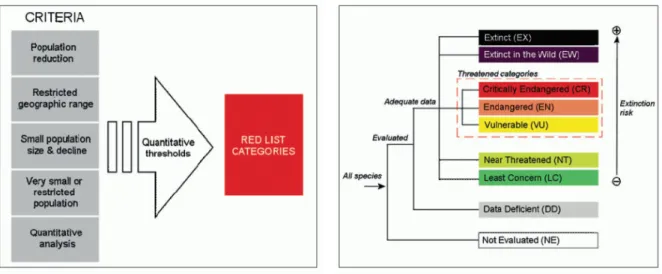
Persistence, on the other hand, is often associated with rarity, looking at species that are restricted either in number or in area to a level that is demonstrably lower than the majority of other organisms of comparable taxonomic entities, putting them at a greater risk of extinction (Flather & Sieg, 2007). Most rarity approaches use data from the IUCN Red List (Figure 6 and Figure 7) (IUCN, 2015).
Figure 6: Criteria used for IUCN Red List categorisation (IUCN, 2015)
Figure 7: IUCN Red List categories (IUCN, 2015)
Often the resources are not sufficient for the full achievement of the two goals, forcing the prioritisation of one over the other, pitching conservation of areas with high diversity against areas with rare species at a high extinction risk. The legislation of most countries commonly benefits the latter option.
It is worth noting that a number of authors see the use of richness and rarity as obsolete terms in conservation planning, preferring to use instead irreplaceability and vulnerability (Brooks et al., 2006; Kukkala & Moilanen, 2013). We will, however, continue to use the referred terms for the sake of their recognisability to other stakeholders in the conservation planning process.
22
in the territory — and particularly for conservation area selection and the safeguard of important natural phenomena such as migrations (Margules & Pressey, 2000).
Finally, it is important to mention conservation goals and targets related to cost and other social-economic commitments and constrains. Conservation planning is often compatible with the development of complementary socio-economic development goals and targets (Naidoo et al., 2006). Activities such as tourism and outdoor practices that are certified as sustainable (adding value to products) have become socio-economic motors to the improvement of many communities.
The revised and updated Strategic Plan for Biodiversity for the 2011-2020 period (CBD Secretariat, 2015), signed in Nagoya, provided a new global overarching framework on biodiversity, not only for the biodiversity-specific conventions but also for the broader United Nations System and all other partners engaged in biodiversity management and policy development.
This update created the new set of goals and targets to be achieved, best known as the Aichi Biodiversity Targets. The twenty Aichi Biodiversity Targets are organised around five main goals (Appendix 1). Perhaps the best-known of those targets is the increase in the percentage of protected area.
2.6
Evolution of methods for reserve selection
Even with the present recognition that many conservation goals require the management of whole landscapes, protected areas and natural reserves are still the cornerstones on which most regional conservation strategies are built; their role is to
“separate elements of biodiversity from processes that threaten their existence in the wild. They must do this within the constraints imposed by large and rapidly increasing numbers of humans in many parts of the world and their attendant requirements for space, materials and waste disposal” (C. R. Margules & Pressey, 2000b).
23
These reserved areas, specifically protected and put aside for nature conservation, can be designated both by government institutions or private landowners, such as charities and research institutions. They are labelled under a range of different names depending on their size, objectives, degree of protection, and applicable national laws (IUCN, 2008). This means that national parks, natural parks, natural reserves, etc. might have different scales and degrees of protection depending on the country in which they are located.
The need for international recognised standards for defining protected areas and encourage conservation planning according to their management aims led to the development of the IUCN Protected Area Management Categories, which classify protected areas into six classes according to their management objectives, summarised in (Table 1) (United Nations Environment Programme, 2015). To apply to one, protected areas must have at least 75% (three-quarters) of the area dedicated to a specific management objective; other management purposes may occur in the 25% remaining if compatible with the primary objective of the protected area (IUCN, 2008).
Historically, the creation of reserves and protected areas has generally followed an ad hoc approach, based mostly on worth perception, opportunistic land availability, and reaction to destruction threats. Spaces were typically reserved for protection because they were perceived as important for desirable species or for their scenic, recreational, and cultural values. It was also often the case where a reserve was created opportunistically, out of inexpensive or undesirable patches of land (R. L. Pressey, 1994; Trombulak, 2010).
This ad hoc strategy, in use until recently, ended up being a double-edged sword. If on one hand it protected natural resources and species that otherwise would already be extinct, its low effectiveness in representing biodiversity and its inefficiency in achieving more comprehensive conservation goals mined the confidence in reserves and their conservation aptitude (R. L. Pressey, 1994; Trombulak, 2010).
Major advances in sciences like biogeography and conservation biology — together with the need to find a methodology for reserve selection based on scientific facts, which could justify and boost confidence in the areas selected for protection and often attacked by social and economic interests — led to the development of the systematic conservation planning methodology at the end of the 20th century (Kukkala & Moilanen, 2013; Margules &
24
Table 1: IUCN Protected Area Management Categories (IUCN, 2008)
Category Definition by management objectives
Category Ia
Strict Nature Reserve
Protected areas that are strictly set aside to protect biodiversity and also possibly geological/geomorphological features, where human visitation, use, and impacts are strictly controlled and limited to ensure protection of the conservation values. Such protected areas can serve as indispensable reference areas for scientific research and monitoring.
Category Ib Wilderness Area
Protected areas that are usually large unmodified or slightly modified areas, retaining their natural character and influence, without permanent or significant human habitation, which are protected and managed so as to preserve their natural condition.
Category II National Park
Large natural or near-natural areas set aside to protect large-scale ecological processes, along with the complement of species and ecosystems characteristic of the area, which also provide a foundation for environmentally and culturally compatible spiritual, scientific, educational, recreational, and visitor opportunities.
Category III
Natural Monument or Feature
Protected areas set aside to protect a specific natural monument, which can be a landform, sea mount, submarine cavern, geological feature, such as a cave, or even a living feature, such as an ancient grove. They are generally quite small and often have high visitor value. Category IV
Habitat/Species Management Area
Protected areas aiming to protect particular species or habitats and whose management reflects this priority. Many protected areas in this category will need regular, active interventions to address the requirements of particular species or to maintain habitats, but this is not a requirement.
Category V Protected
Landscape/Seascape
A protected area where the interaction of people and nature over time has produced a distinct character with significant ecological, biological, cultural, and scenic value, and where safeguarding the integrity of this interaction is vital to protecting and sustaining the area and its associated nature conservation as well as other values.
Category VI Protected Area with Sustainable use of Natural Resources
Protected areas that conserve ecosystems and habitats together with associated cultural values and traditional natural resource management systems. They are generally large, with most of the area in a natural condition, with a proportion under sustainable natural resource management and where low-level non-industrial use of natural resources compatible with conservation is seen as one of the main aims.
Systematic conservation planning aims to offer a framework for a structured multi-component stage-wise approach to prioritising and managing habitats deemed important for conservation, with feedback, revision, and reiteration at any stage (Margules & Sarkar, 2007; Sarkar & Illoldi-Range, 2010).
This new way of looking at reserves creation and the definition of conservation area, a term that has presently substituted “reserve” in systematic conservation planning speech, understands the importance of explicit goals, of local and broader context priorities, and of social, economic, and political imperatives that drastically modify what would be the scientific prescriptions (Margules & Sarkar, 2007; Sarkar & Illoldi-Range, 2010; Sarkar, 2014).
Over the last few decades, the systematic conservation planning framework has been developed by many scientific groups, creating new and updated work protocols, rendering them more complex and adding components (Sarkar & Illoldi-Range, 2010).
real-25
world implementations. These additional contributions resulted in extended frameworks of eleven stages (Appendix 2) and, more recently, fourteen stages (Table 3) that still retain the core stages of the original approach (Robert L. Pressey & Bottrill, 2008; Sarkar & Illoldi-Range, 2010; Sarkar, 2014).
Table 2: First systematic conservation planning framework (Margules & Pressey, 2000)
Stages Tasks and decisions
Compile data on the biodiversity of the planning region
Review existing data and decide on which data sets are sufficiently consistent to serve as surrogates for biodiversity across the planning region
If time allows, collect new data to augment or replace some existing data sets
Collect information on the localities of species considered to be rare and/or threatened in the region, likely to be missed or under-represented in conservation areas selected only on the basis of land classes such as vegetation types
Identify conservation goals for the planning region
Set overall conservation targets that aim to achieve representativeness and persistence goals
Set quantitative conservation targets for species, vegetation types or other features. That, although subjective, are valuable on account of their explicitness
Set quantitative targets for minimum size, connectivity, or other design criteria
Identify qualitative targets or preferences Review existing
conservation areas
Measure the extent to which quantitative targets for representation and design have been achieved by existing conservation areas
Identify the imminence of threat, to under-represented features such as species or vegetation types, and the threats posed to areas that will be important in securing satisfactory design targets
Select additional conservation areas
Regard established conservation areas as “constraints” or focal points for the design of an expanded system
Identify preliminary sets of new conservation areas for consideration as additions to established areas, taking into account complementarity, irreplaceability, vulnerability and cost, commitments, and other social constrains
Implement conservation actions
Decide on the most appropriate or feasible form of management to be applied to individual areas
Decide on the relative timing of conservation management when resources are insufficient to implement the whole system in the short term
Maintain the required values of conservation areas
Set conservation goals at the level of individual conservation areas, ideally
acknowledging the particular values of the area in the context of the whole system.
Implement management actions and zoning in and around each area to achieve the goals
Monitor key indicators that reflect the success of management actions or zonings in achieving goals and modify management as required
The development of the systematic conservation framework and the treatment of its multi-component complexity have been strongly assisted by the simultaneous developments in information and communication technologies.