Braz. J. of Develop.,Curitiba, v. 6, n. 7, p.53148- 53164 jul. 2020. ISSN 2525-8761
Evaluation of areas with environmental vulnerability in the Rio Claro
hydrographic basin, SP – Brazil
Avaliação de áreas com vulnerabilidade ambiental na bacia hidrográfica do
Rio Claro, SP - Brasil
DOI:10.34117/bjdv6n7-820
Recebimento dos originais:08/06/2020 Aceitação para publicação:30/07/2020
Diego Peruchi Trevisan
Mestrado em Ciências Ambientais
Instituição de atuação atual: Universidade Federal de São Carlos Endereço completo: Rod. Washington Luiz, s/n, São Carlos - SP, 13565-905
Email: [email protected]
Ana Claudia Pereira Carvalho
mestrado em Geotecnia
Instituição de atuação atual: Universidade Federal de São Carlos Endereço completo: Rod. Washington Luiz, s/n, São Carlos - SP, 13565-905
E-mail: [email protected]
Ana Paula Jacó
Mestrado em Ciências Ambientais
Instituição de atuação atual: Universidade Federal de São Carlos Endereço completo: Rod. Washington Luiz, s/n, São Carlos - SP, 13565-905
E-mail: [email protected]
Naara Aline Tossani de Melo
Mestrado em Ciências Ambientais
Instituição de atuação atual: Universidade Federal de São Carlos Endereço completo: Rod. Washington Luiz, s/n, São Carlos - SP, 13565-905
E-mail: [email protected]
Polyanna da Conceição Bispo
doutorado em Sensoriamento Remoto Instituição de atuação atual: Manchester University
Endereço completo: Oxford Rd, Manchester M13 9PL, United Kingdom E-mail: [email protected]
Luciana Ruggiero Bachega
Doutora em Ciências (Recursos Florestais)
Instituição de atuação atual: Universidade Federal de São Carlos Endereço completo: Rod. Washington Luiz, s/n, São Carlos - SP, 13565-905
Braz. J. of Develop.,Curitiba, v. 6, n. 7, p.53148- 53164 jul. 2020. ISSN 2525-8761
Junio da Silva Luiz
graduação em Engenharia Ambiental
Instituição de atuação atual: Universidade Federal de São Carlos Endereço completo: Rod. Washington Luiz, s/n, São Carlos - SP, 13565-905
Email: [email protected]
José Augusto de Lollo
Doutor em Engenharia Civil - Geotecnia
Instituição de atuação atual: Universidade Federal de São Carlos Endereço completo: Rod. Washington Luiz, s/n, São Carlos - SP, 13565-905
E-mail: [email protected]
Luiz Eduardo Moschini
doutor em Ecologia e Recursos Naturais
Instituição de atuação atual: Universidade Federal de São Carlos Endereço completo: Rod. Washington Luiz, s/n, São Carlos - SP, 13565-905
Email: [email protected]
Reinaldo Lorandi
doutorado em Solos e Nutrição de Plantas
Instituição de atuação atual: Universidade Federal de São Carlos Endereço completo: Rod. Washington Luiz, s/n, São Carlos - SP, 13565-905
E-mail: [email protected]
ABSTRACT
The environmental vulnerability study is one of the most important ways to analyze the anthropic pressures that occur in the physical and biological environment. In this context, the aim of this work is to evaluate the areas with environmental vulnerability in the Rio Claro Hydrographic Basin in 2001 and 2017, using physical and biological factors. The hydrographic basin has 251.91km² and is localized in the Santa Rita do Passa Quatro (SP). The analysis was carried out addressing the physical attributes (slope, geology, unconsolidated materials, and aquifer units) and biological attributes with use and land cover for 2001 and 2017. The methodology was based on the environmental characterization and standardization of the information through the Fuzzy logic, processed in ArcGIS 10.5 software. The data were classified into five levels of environmental vulnerability (very low, low, medium, high and very high). For both periods, the most evident levels were the low, medium and high vulnerability, occupying over 70%. The method employed in this work allowed the evaluation of the environmental vulnerability in the Rio Claro Hydrographic Basin and made possible the definition of the regions that suffered interference due to the influence of the anthropic activities in the physical and biological environment, as well as of the different activities that occurred in the region.
Keywords: Anthropogenic Activities, Environmental planning, Fragility, Fuzzy Logic, GIS. RESUMO
O estudo de vulnerabilidade ambiental é uma das formas mais importantes para analisar as pressões antrópicas que ocorrem no ambiente físico e biológico. Nesse contexto, o objetivo deste trabalho é avaliar as áreas com vulnerabilidade ambiental na Bacia Hidrográfica de Rio Claro em 2001 e 2017, utilizando fatores físicos e biológicos. A bacia hidrográfica possui 251,91 km² e está localizada em
Braz. J. of Develop.,Curitiba, v. 6, n. 7, p.53148- 53164 jul. 2020. ISSN 2525-8761
Santa Rita do Passa Quatro (SP). A análise foi realizada abordando os atributos físicos (declividade, geologia, materiais não consolidados e unidades aquíferas) e atributos biológicos, com uso e cobertura do solo para 2001 e 2017. A metodologia baseou-se na caracterização e padronização ambiental das informações por meio da Lógica Fuzzy, processada no software ArcGis 10.5. Os dados foram classificados em cinco níveis de vulnerabilidade ambiental (muito baixa, baixa, média, alta e muito alta). Para ambos os períodos, os níveis mais evidentes foram a baixa, média e alta vulnerabilidade, ocupando mais de 70%. O método empregado neste trabalho permitiu a avaliação da vulnerabilidade ambiental na Bacia Hidrográfica Rio Claro e possibilitou a definição das regiões que sofreram interferências devido à influência das atividades antrópicas no ambiente físico e biológico, bem como das diferentes atividades que ocorreram na região.
Palavras-chave: Atividades antrópicas, Planejamento ambiental, Fragilidade, Lógica Difusa, SIG
1 INTRODUCTION
Land use has been changed by anthropogenic influences as good manufacturing and urbanization process (DEFRIES; FOLEY; ASNER, 2004; NEWBOLD, 2015). The planning actions without management focused in decrease the damage transformation on the landscape could modify important ecological functions, such as water resources quality, biodiversity sustainability, maintenance of soil fertility (LEE et al., 2009; ZHAO et al., 2015). Hence, ecological zoning is used for land use and land cover planning to show landscape fragility and it is potential (FURLAN; BONOTTO; GUMIERE, 2011; Li, 2017).
According to the Brazilian Ministry of the Environment (MMA, 2017), the concept of environmental vulnerability is defined as the susceptibility degree in which an attribute of the environment, between a set of components and a landscape, offers a response to a certain type of anthropogenic action. In this method, investigations about ecological systems are aimed, where environmental planning and management need to be considered in a multidisciplinary aspect with the objective of sustainable development.
The common impacts of land use in a catchment basin are erosion and soil loss (GESSESSE; BEWKET; BRÄUNING, 2015), caused mainly by deforestation. Also, water resources contamination by fertilization and agricultural defensives are recurrent (CONNOLLY et al., 2015). The environmental vulnerability in these areas must consider some attributes like soil characteristics, permeability, erosion susceptibility and the distance of water sources and groundwater in relation to possible agricultural or urban developed practices.
In the Rio Claro Hydrographic Basin (RCW), as São Paulo state as a whole, there is a high predominance of agricultural activities, mainly by sugarcane, being the largest producer of sugarcane in Brazil (NATALE NETTO, 2007; Martini et al., 2018). However, there no information
Braz. J. of Develop.,Curitiba, v. 6, n. 7, p.53148- 53164 jul. 2020. ISSN 2525-8761
about the impacts of these advances on natural ecosystems, as well as on the environmental quality of these regions, their potentials, and vulnerabilities.
In Brazil, one of the most effective ways to manage integrated regional planning is through the Water Resources Management Units (WRMU) and river basin committees and the environmental vulnerability based on watersheds is widely used (FURLAN; BONOTTO; GUMIERE, 2011; LIU et al., 2015). These areas have important ecosystem functions being a transition between terrestrial and aquatic systems (GREGORY et al., 1991; PETER, 2012). They also act on nutrient cycling conservation and landscape connection (ŞEKERCIOĞLU, 2015).
Several authors have been developing indices and descriptive measures of landscape spatial monitoring and environmental vulnerability (MORETTI, 2007, TREVISAN et al., 2016; REGO et al., 2018). The work of Nghyen and Liou (2019) presented the first global-scale map of quantified eco-environmental vulnerability by integrating remote sensing. The showed on a global scale, a small fraction of the globe (10.1%) is strongly (high and very high vulnerability) affected by influential factors. Among continents, the largest fraction of a very high vulnerability level is attributed to Asia (74.6%) followed by Africa (19.6%).
Remote Sensing and Geographic Information System (GIS) technologies have been improving the acquisition and the quality of the information on river basins facilitating water resources management and creating guidelines for proper management of land use (SMA, 2005; SAVIOUR, 2012; REICHERT et al., 2016). GIS approaches that contemplate ecological and social aspects have been used in different localities (DE FREITAS; TAGLIANI, 2009; HUNKE et al., 2015).
In this context, the aim of this work is to evaluate the areas with environmental vulnerability in the Rio Claro Hydrographic Basin in 2001 and 2017, using physical and biological factors.
2 MATERIAL AND METHODS
2.1 STUDY AREA
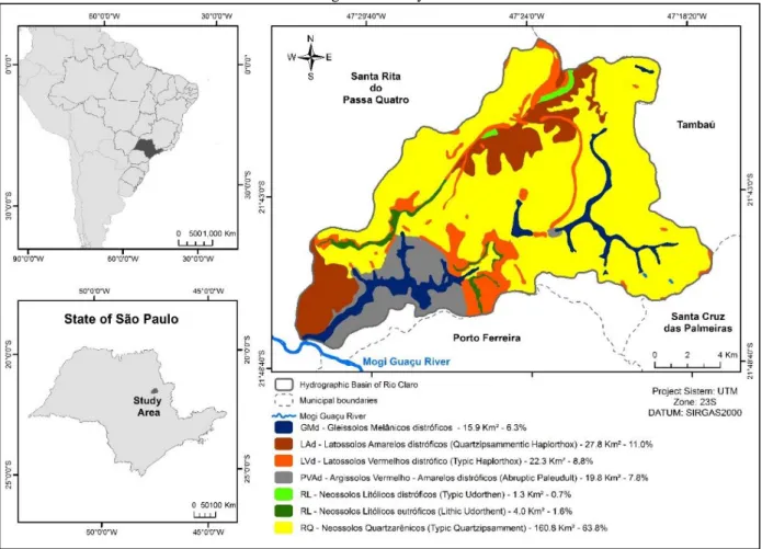
The RCW is located in the Santa Rita do Passa Quatro municipality between the coordinates 47,538946 - 47,292626 west longitude and 21,800682 - 21,632093 south latitude, at São Paulo State, Brazil (Figure 1). The Rio Claro River presents an average to a high density of drainage patterns and is classified as a fifth-order watershed (STRAHLER, 1952; MARQUEZOLA et al., 2016).
The river is a tributary of the Mogi-Guaçu River in the Paraná Basin, and it drains part of the south of Brazil. Mogi-Guaçu Watershed is a Unit for Water Resources Management - UGRHI 9 (in Portuguese) defined in 1994 by the State Law No. 9.034 of 12/27/1994 (SÃO PAULO, 1994).
Braz. J. of Develop.,Curitiba, v. 6, n. 7, p.53148- 53164 jul. 2020. ISSN 2525-8761
The UGRHI is governed by the Mogi-Guaçu River Basin Committee (CBH-MOGI), installed on June 05/04/1996.
Santa Rita do Passa Quatro has a population of 26.397 and an extension of 251,91km² (IBGE, 2019). The regional climate is classified as Cwa (Köppen), with dry winter, between October and April, and moist summer, among May and September. The temperature ranges from 17.5ºC to 23.5ºC and the annual rainfall is 1506mm. The RCW is situated in one of the most important water source zones, the Guarani and the Serra Geral groundwater (CEPAGRI, 2018).
Figure 1 - Study area
Source: The authors
RCW morphology (Table 1) is in the peripheral depression of the Mogi-Guaçu River zone and is sculpted almost entirely by the Paleo-Mesozoic sediments of the basin (MARQUEZOLA, 2016). It is composed of hills with broad tabular tops, slope shapes average of 5 and 10% and dominant elevation between 500 e 650m. RCW land use is related to agribusiness activities like sugarcane, silviculture, and pastures. The development of these activities has replaced the natural land-cover, Brazilian semideciduous seasonal forests, Savannah (Cerrado), which has been increased the deforestation rate (MARQUEZOLA et al. 2016).
Braz. J. of Develop.,Curitiba, v. 6, n. 7, p.53148- 53164 jul. 2020. ISSN 2525-8761
Table 1 - Geologic Formation of the Rio Claro Hydrographic Basin Group Unit Era Period Description Alluvial deposits (Qa) Cenozoic; Holocene
They are represented by plains that occur along the Ribeirão do Meio valley and Taquari and Invernada stream. They are alluvial and colluvial sediments of sandy texture due to the contribution of the adjacent lithologies. It is common for the presence of organic matter in the superficial layers.
Piraçununga (Qdi_p) and Santa
Rita do Passa Quatro (Qdi_sr)
formations
Cenozoic; Pleistocene
Consisting of unconfined sandy sediments of continental origin, non-stratified and without structure, vertically homogeneous, overlapping indifferently to the earliest formations, on the basis of which pebble lines have sometimes been found. In terms of thickness, the Piraçununga formations reach 5m, while the Santa Rita do Passa Quatro thickness up to 20m.
São Bento; Basic Tabular Intrusives
(Kδsg)
Mesozoic Cretaceous
They are regionally constituted of sills and dikes, presenting intensely fractured and dense appearance. In aerial photographs, they have dark gray shades, abrupt slopes, and preferential distribution. In the study area, they present dikes associated with normal faults in the western portion, while in the east they present themselves in the form of extensive sills.
São Bento; Botucatu formation (JKbt) Mesozoic Jura/ Cretaceous
It is consisting of winding sandstones attributed to deposits in a desert environment, with fine to medium granulation particles and essentially quartzous composition (80%), the thickness varies between 20 and 280m. It has a large number of interconnected pores and a high capacity to store and supply water. In aerial photos, they present characteristics similar to those of the Pirambóia Formation.
São Bento; Pirambóia formation (PTp) Mesozoic Triassic
Composed of fluvial whitish, yellowish and pinkish sandstones, medium to fine, sometimes quite clayey, due to stratigraphic positioning. In aerial photographs, they have light gray to white shades, with an underdeveloped drainage system with a dendritic pattern.
Passa Dois; Corumbataí formation (PTc) Paleozoic Permian
Composed, regionally, by variegated shales, being positioned between Irati (lower) and Pirambóia (upper) formations. In aerial photographs, print dark gray tones and high drainage density with a punctured pattern. The most expressive outcrops are found in the study area, distributed to the west and southwest of Pirassununga (SP).
Source: Adapted from IBGE (1998)
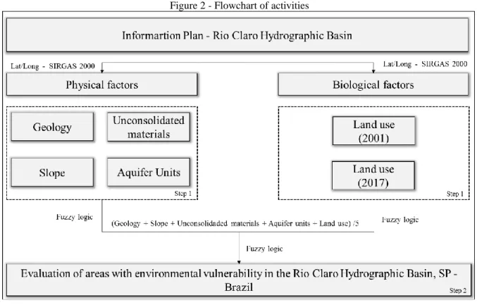
2.2 METHODOLOGY
Physical and biological attributes (Figure 2) were used to evaluate the areas with environmental vulnerability in the Rio Claro Hydrographic Basin. The data was performed with
Braz. J. of Develop.,Curitiba, v. 6, n. 7, p.53148- 53164 jul. 2020. ISSN 2525-8761
ArcGIS 10.5, using the datum SIRGAS2000 and the Universal Transverse Mercator (UTM 23S) projection for all information plan, divided into two stages.
Figure 2 - Flowchart of activities
Source: The authors
In the first stage (Table 2), the acquisition of the database was made with physics aspects (aquifer units, slope shapes, soils, geological formation) and biological (use and land cover from 2001 and 2017).
Table 2 - Geo-environmental attributes/sources.
Data Description Source Scale
Hydrography Rivers Topography charts (IBGE, 1971)
1:50.000 Aquifer units Delimitation of the
aquifer units
Aquifer Units Applied to Geo-Environmental Zoning (LORANDI et al., 2016) Slope shapes Classes of slope Topography charts (IBGE, 1971)
Geology Geological formations Geology charts (LORANDI et al., 2016) Soils Classes of soils GUERRERO et al (2016)
Land use - 2017 Classes of land use
Landsat 8 - sensor OLI/TIRS, bands 6/5/4. Orbit/point 220/75. Orbit/point 220/75.
Braz. J. of Develop.,Curitiba, v. 6, n. 7, p.53148- 53164 jul. 2020. ISSN 2525-8761
Land use - 2001 Classes of land use
Landsat 5 - sensor TM, bands 5/4/3. Orbit/point 220/75.
(USGS, 2017) March 23, 2017.
Geomorphology Relief forms Geomorphometric database (TOPODATA, 2008) 1:250.000 Source: Authors
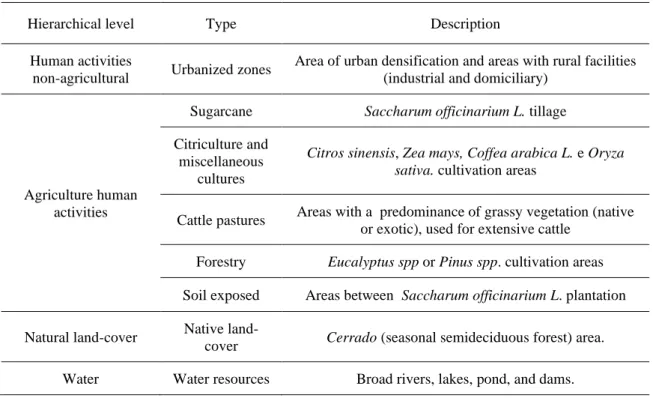
Land use was classified based on a multilevel system (IBGE, 2013) (Table 3). In the primary hierarchical level I four classes were included that indicate the main use and land cover categories. The secondary hierarchical level II analyzed the types of land uses that were included in the first level. The tertiary hierarchical level III explained the land uses themselves.
The periods of March and April were chosen due to the seasonality of the prevailing agricultural practices in the region. The time gap of 10 years between the images allowed the study of the temporal patterns of the landscape.The use of different satellite scenes occurred due to the unavailability of images by a single satellite during the study period. The scenes used for this study were worked in the same spatial resolution of 30 meters.
Table 3 - Land use hierarchical level.
Hierarchical level Type Description
Human activities
non-agricultural Urbanized zones
Area of urban densification and areas with rural facilities (industrial and domiciliary)
Agriculture human activities
Sugarcane Saccharum officinarium L. tillage
Citriculture and miscellaneous
cultures
Citros sinensis, Zea mays, Coffea arabica L. e Oryza sativa. cultivation areas
Cattle pastures Areas with a predominance of grassy vegetation (native or exotic), used for extensive cattle
Forestry Eucalyptus spp or Pinus spp. cultivation areas
Soil exposed Areas between Saccharum officinarium L. plantation Natural land-cover Native
land-cover Cerrado (seasonal semideciduous forest) area. Water Water resources Broad rivers, lakes, pond, and dams.
Source: Authors
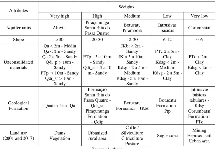
In the second stage, the physical and biological variables were classified in accordance with their degree of vulnerability to anthropic intervention (Table 4), where all the environmental attributes received hierarchical weights in a 1 to 5 scale based on the study area knowledge.
Braz. J. of Develop.,Curitiba, v. 6, n. 7, p.53148- 53164 jul. 2020. ISSN 2525-8761
Table 4 - Geo-environmental attributes/sources.
Attributes Weights
Very high High Medium Low Very low
Aquifer units Aluvial
Piraçununga Santa Rita do Passa Quatro Botucatu Piramboia Intrusivas básicas Corumbataí Slope >30 20-30 12-20 6-12 0-6 Unconsolidated materials Qa < 2m - Média Qa < 2m - Sandy Qa 2 a 5m - Sandy Qdi_p > 10m - Sandy PTp > 10m - Sandy Qdi_sr > 10m - Sandy PTp - 5 a 10 m - Sandy Qdi_sr - 5 a 10 m - Sandy JKbt < 2m - Sandy JKbt 5 a 10m - Sandy Kdsg - 2 a 5m - Medium Kdsg - 5 a 10m - Sandy PTc 2 a 5m - Clay Kdsg < 2m - Medium Kdsg - 2 a 5m - Clay PTc < 2m - Clay Kdsg < 2m - Clay Geological Formation Quaternário- Qa Formação Santa Rita do Passa Quatro - Qdi_sr Piraçununga Formation - Qdip Botucatu Formation - JKbt Botucatu Formation - Ptp Intrusivas básicas tabulares - Kdsg Corumbataí Formation - PTc Land use (2001 and 2017) Dams Vegetation Urbanized rural area Coffe / Silviculture Citriculture Pasture Sugar cane Mining Exposed soil Urban area Source: Authors
The variables collected had different natures. Thus, to obtain comparability and adjustment of the data to a common scale of work, it was necessary to standardize the criteria. In this way, the spatial representation of the values obtained from the application of the proposed indexes was scaled based on fuzzy logic (FUZZY), of linear type [y = f (x)], with values from zero (0) to one (1).
The study was carried out on a multi-criteria evaluation (JIANG; EASTMAN, 2000) to describe relevance areas for ecological conservation and human activities at the watershed scale, in this way degree of vulnerability to anthropic intervention, considering the equation;
𝐸𝑉 = (𝐺𝑒𝑜𝑙𝑜𝑔𝑦 + 𝑆𝑙𝑜𝑝𝑒 + 𝑈𝑛𝑐𝑜𝑛𝑠𝑜𝑙𝑖𝑑𝑎𝑡𝑒𝑑𝑑 𝑚𝑎𝑡𝑒𝑟𝑖𝑎𝑙𝑠 + 𝐴𝑞𝑢𝑖𝑓𝑒𝑟 𝑢𝑛𝑖𝑡𝑠 + 𝐿𝑎𝑛𝑑 𝑢𝑠𝑒) 5
3 RESULTS AND DISCUSSIONS
The physical and biological attributes (slope, geology, soils, aquifer units and land use and occupation) are presented in Figure 3. The low, medium and high vulnerability classes present more frequency for the two periods, occupying a percentage of 73.5% for 2001 and 78.4% for 2017 (Figure 4). The principal attribute that caused changes in the charts was the use and land cover since
Braz. J. of Develop.,Curitiba, v. 6, n. 7, p.53148- 53164 jul. 2020. ISSN 2525-8761
it is the only factor that demonstrates considerate modifications in the study area for a long time. Table 3 presents the percentage of area occupied by each type of use and land cover mapped.
In the 16-year period, it is possible to notice the growth of the urban area and the sugar cane plantation, where the areas of the exposed soil also related. In addition, the pasture present greater evidence for 2017 (10.4%) compared to 2001 (3.2%).
Braz. J. of Develop.,Curitiba, v. 6, n. 7, p.53148- 53164 jul. 2020. ISSN 2525-8761
Braz. J. of Develop.,Curitiba, v. 6, n. 7, p.53148- 53164 jul. 2020. ISSN 2525-8761
For a detailed analysis of the Environmental Vulnerability, each of the five classes was described, considering the environmental attributes adopted.
Table 3 - Use and land cover in Rio Claro Hydrographic Basin for 2001 and 2017.
Land Use 2001 (%) 2017 (%) Water 0,20 0,20 Urban 1,90 2,80 Coffe 1,50 0,10 Sugarcane 37,60 50,30 Pasture 3,20 10,40 Citriculture 0,20 1,20 Silviculture 1,30 4,40 Exposed soil 19,10 4,30 Vegetation 35,00 26,30 Source: Authors
Very low environmental vulnerability: this class is distributed in the extreme south of the hydrographic basin, the environmental attributes that define this classification are the soils originating from the Corumbataí Formation, with thicknesses that vary below 2m and can reach up to 5m. Geology is composed of variegated shales. The very low vulnerability is also found in the central region of the basin with soils from Basic Tabular Intrusives, which are characteristic of clayey texture. In addition, it is a shallow soil with a thickness that can reach up to 2m. The slope present in these regions ranges from < 6% to 20%.
It can be noticed that from the year 2001 to 2017 there was a decrease in the class very low environmental vulnerability. Since 2001, the exposed soil was more presented, however, in 2017, these areas were occupied by sugar cane or other activities.
Low environmental vulnerability: this is the vulnerability class with the greatest predominance in 2001 and 2017. It is spatialized throughout the hydrographic basin, mainly in the central region, whose soil comes from the Piramboia Formation presenting > 10m of thick and sandy texture.
This class is more concentrated where the relief has smooth undulating and interflowing flattened. There was a small decrease in the area occupied by this class in the river basin due to changes in land use and occupation. Since 2001, this class occupied a percentage of 30.6%, while in 2017 fell to 27.5%.
Medium environmental vulnerability: this class is distributed among all the study area. There was an increase from 2017 (25.8%) in relation to 2001 (19%). This is also a reflection of the
Braz. J. of Develop.,Curitiba, v. 6, n. 7, p.53148- 53164 jul. 2020. ISSN 2525-8761
use and land cover. It is worth noting that the region where coffee was occupied in 2001 was exchanged for sugar cane, once an area considered to be highly vulnerable, currently characterized as being of medium environmental vulnerability.
This class is associated with regions that present mainly soils of the Santa Rita do Passa Quatro and Piraçununga formation, present thickness > 10m and sandy texture. It is located to the north and northwest of the hydrographic basin. On the northeast are soils of the Piramboia Formation with thickness > 10m with a sandy texture. In the southern region there are soils originating from the Quaternary Formation whose thickness varies from 2 to 5m, presents sandy texture. The slope ranges from < 6% to 20%.
High environmental vulnerability: There was a change in 2001 of 23.5% to 25.1% in 2017. This classification is associated with the soils originating from the Piramboia and Santa Rita do Passa Quatro Formations, which have a thickness > 10m, and sandy texture. On the southern, presents soils originating from Basic Tabular Intrusives with a thickness of 5 to 10m, and medium texture.
Very high environmental vulnerability: these classes are associated with the natural vegetation, dams and exposed soil. This class is spatialized along the hydrographical basin, presents regions with a slope from < 6% to 20%.
In this way, it is evident the tendency of loss of the environmental quality present in the region, caused by the expansion of the agricultural and urban frontiers without environmental planning, interfering in the conservation and maintenance of the environmental services provided by the ecosystems.
This scenario is also observed in other studies (PINATTI et.al, 2013; Trevisan; Moschini, 2015), which demonstrate the loss of environmental quality due to the expansion of agricultural frontiers, evidencing the expansion of sugarcane cultivation and the suppression of areas of native vegetation and the substitution of other agricultural practices.
4 CONCLUSIONS
The method employed in this work allowed the evaluation of the environmental vulnerability in the Rio Claro Hydrographic Basin and made possible the definition of the regions that suffered interference due to the anthropic activities in the physical and biological environment. The use of the Geographic Information System was important for the elaboration of the results since it is an instrument that presents resources to analyze a series of data and cartographic
Braz. J. of Develop.,Curitiba, v. 6, n. 7, p.53148- 53164 jul. 2020. ISSN 2525-8761
information through map algebra, aiming to obtain an integrated knowledge to understand the environmental dynamics.
The results will allow guiding the public managers in the decision making, aiming at strategic planning in order to mitigate socio-environmental problems that can occur in the regions of greater environmental vulnerability; besides, it serves as contribute to helping future occupations to consider socioeconomic development together with environmental preservation.
ACKNOWLEDGMENTS
The authors would like to acknowledge the São Paulo Research Foundation (Process 2015/19918-3 and 2018/00162-4) for the fund for this project.
Braz. J. of Develop.,Curitiba, v. 6, n. 7, p.53148- 53164 jul. 2020. ISSN 2525-8761
REFERENCES
CEPAGRI. Centro de Pesquisas Meteorológicas e Climáticas Aplicadas a Agricultura, da UNICAMP. 2018. Available in <http://www.cpa.unicamp.br/outras-informacoes/clima_muni_531.html>. Accessed on May 26, 2018.
CONNOLLY, N. M.; PEARSON, R.G.; LOONG, D.; MAUGHAN, M.; BRODIE, J. Water quality variation along streams with similar agricultural development but contrasting riparian vegetation.
Agriculture, Ecosystems and Environment, v.213, n. x, p.11–20, 2015.
CPRM. Serviço Geológico do Brasil. Sistema de Informações de Águas Subterrâneas
(SIAGAS), 2005. Available in: <http://siagasweb.cprm.gov.br/layout/pesquisa_complexa.php>.
Accessed on May 26, 2018.
DE FREITAS, D. M.; TAGLIANI, P. R. A. The use of GIS for the integration of traditional and scientific knowledge in supporting artisanal fisheries management in southern Brazil. Journal of
Environmental Management, v.90, n.6, p.2071–2080, 2009.
DEFRIES, R. S.; FOLEY, J. A.; ASNER, G. P. Land-use choice: balancing human needs and ecosystem function. Frontiers in Ecology and the Environment, v.2, n.5, p. 249–257, 2004.
FURLAN, A.; BONOTTO, D. M.; GUMIERE, S. J. Development of environmental and natural vulnerability maps for Brazilian coastal at São Sebastião in São Paulo State. Environmental Earth
Sciences, v.64, n.3, p.659–669, 2011.
GESSESSE, B.; BEWKET, W.; BRÄUNING, A. Characterization and Monitoring of Runoff and Soil Erosion in Response to Land Use/Land Cover Changes in the. Land Degrad. & Develop. v.26, p.711–724, 2015.
GREGORY, S. V.; SWANSON, F.J.; MCKEE, W. A.; CUMMINS, K. W. An Ecosystem Perspective of Riparian Zones. BioScience, v. 41, n. 8, p. 540–551, 1991.
GUERRERO, J. V. R.; LOLLO, J. A.; LORANDI, R. Cartografia Geoambiental Como Base Para Planejamento Territorial Na Bacia Do Rio Clarinho, SP. Revista Brasileira de Cartografia, v.68, Edição Especial Aplicações dos SIG: 313-326, 2016.
HUNKE, P.; MUELLER, E.N.; SHRODER, B.; ZEILHFER, P. The Brazilian Cerrado: Assessment of water and soil degradation in catchments under intensive agricultural use. Ecohydrology, v.8, n.6, p.1154–1180, 2015.
IBGE. Brazilian Institute of Geography and Statistics. Geology manual, 1998. Available < https://biblioteca.ibge.gov.br/biblioteca-catalogo?id=27919&view=detalhes> Accessed on Jun 20, 2018.
IBGE. Brazilian Institute of Geography and Statistics. IBGE – Demographic Census. 2018. Available <http://mapasinterativos.ibge.gov.br/grade/default.html> Accessed on Jun 20, 2018.
IBGE. Brazilian Institute of Geography and Statistics. Land use manual, 2013. Available <
Braz. J. of Develop.,Curitiba, v. 6, n. 7, p.53148- 53164 jul. 2020. ISSN 2525-8761
IBGE. Brazilian Institute of Geography and Statistics. Topographic Charts – Rio Claro - SF-23-V-C-IV-2, SF-23-V-C-V-1, SF-23-V-C-IV-4 and SF-23-V-C-V-3, 1971. Available <http://mapasinterativos.ibge.gov.br/grade/default.html> Accessed on Jun 20, 2018.
JIANG, HONG; EASTMAN, J. RONALD. Application of fuzzy measures in multi-criteria evaluation in GIS. International Journal of Geographical Information Science, v. 14, n. 2, p. 173-184, 2000.
LEE, S. W.; HWANG, S. J.; LEE, S.B.; HWANG, H.S.; SUNG, H.C. Landscape ecological approach to the relationships of land use patterns in watersheds to water quality characteristics.
Landscape and Urban Planning, v. 92, n. 2, p. 80–89, 2009.
LI, Z.; WU, W.; LIU, X.; FATH, B. D.; SUN, H.; LIU, X.; XIAO, X.; CAO, J. Land use/cover change and regional climate change in an arid grassland ecosystem of Inner Mongolia, China.
Ecological Modelling, v.353, p.86–94, 2017.
LIU, X.; WU, E.; LIU, X.; FAITH, B.D.; SUN, H.; LIU, X.; XIAO, X.; CAO, J. Zoning of rural water conservation in China: A case study at Ashihe River Basin. International Soil and Water
Conservation Research, v.3, n.2, p.130–140, 2015.
LORANDI, R.; LOLLO, J. A. Carta de Unidades Aquíferas Aplicada ao Zoneamento GeoAmbiental. IV Congresso Nacional de Geotecnia, p.1 – 8, 2016.
MARQUEZOLA, D. S.; SERIKAWA, V. S.; LOLLO, J. A.; LORANDI, R. Emprego das unidades de relevo no planejamento territorial da bacia do Rio Claro (SP), na escala 1:50.000. In: SIMPÓSIO DE GEOTECNOLOGIAS NO PANTANAL, 2016, Cuiabá-MT. Anais. Cuiabá: Embrapa Informática Agropecuária/INPE, 2016. p. 255 -264.
MMA. MINISTÉRIO DO MEIO AMBIENTE. Vulnerabilidade Ambiental, Desastres naturais
ou fenômenos induzidos?, 2017. Available in:
<http://fld.com.br/uploads/documentos/pdf/Vulnerabilidade_Ambiental_Desastres_Naturais_ou_F enomenos_Induzidos.pdf >. Accessed on Jun 28 2018.
MORETTI, R. S. Conteúdo e procedimentos de elaboração dos planos diretores IN: BUENO, L.M.M.; CYMBALISTA, R. Planos diretores municipais – novos conceitos do planejamento territorial (Org). São Paulo. ANNABLUME, p.265-271, 2007.
NEWBOLD, T. Global effects of land use on local terrestrial biodiversity. Nature, v. 520, n.7545, p.45–50, 2015.
NGUYEN, K.; LIOU, Y. Global mapping of eco-environmental vulnerability from human and nature disturbances. Science of The Total Environment. V. 664, p.995-1004, 2019.
PETER, S. Nitrate removal in a restored riparian groundwater system: functioning and importance of individual riparian zones. Biogeosciences Discussions, v.9, n.6, p.6715–6750, 2012.
PINATTI, J.M.; MOSCHINI, L. E.; DOS SANTOS, R.M.; TREVISAN, D. P. Dinâmica da Paisagem da Zona de Amortecimento do Parque Estadual do Vassununga, SP. In: SANTOS, J.E.;
Braz. J. of Develop.,Curitiba, v. 6, n. 7, p.53148- 53164 jul. 2020. ISSN 2525-8761
ZANION, E.M. (Org.). Faces da Polissemia da Paisagem. 1ed.São Carlos, SP: Rima, 2013, v. 5, p. 144-162
REGO, J. C. L.; SOARES-GOMES, A.; SILVA, F. S. Loss of vegetation cover in a tropical island of the Amazon coastal zone (Maranhão Island, Brazil). Land Use Policy, v.71, p. 593 - 601, 2018.
REICHERT, J. M.; AMADO, T. J. C.; REINERT, D. J.; RODRIGUES, M. F.; SUZUKI, L. E. A. S. Land use effects on subtropical, sandy soil under sandyzation/desertification processes.
Agriculture, Ecosystems & Environment, v.233, p.370-380, 2016.
SÃO PAULO. State law n.9.034/1994, 1994. Available in < https://www.al.sp.gov.br/repositorio/legislacao/lei/1994/lei-9034-27.12.1994.html> Accessed on February 26. 2018.
SAVIOUR, M. Naveen. Environmental impact of soil and sand mining: a review. International
Journal of Science, Environment and Technology, v.1, n.3, p.125-134, 2012.
ŞEKERCIOĞLU, Ç. H. Tropical countryside riparian corridors provide critical habitat and connectivity for seed-dispersing forest birds in a fragmented landscape. Journal of Ornithology, v.156, p.343–353, 2015.
SMA. Inventário florestal da vegetação natural do Estado de São Paulo. [s.l: s.n.], 2005. TOPODATA. Geomorphometric database, 1:250.000, 2017. Available < http://www.webmapit.com.br/inpe/topodata/> Accessed: Jun 20, 2018.
TREVISAN, D. P.; MOSCHINI, L. E. Dinâmica de Uso e Cobertura da Terra em Paisagem no Interior do Estado de São Paulo: Subsídios para o planejamento. Fronteiras: Journal of social, technological and environmental science, v. 4, p. 16-30, 2015.
TREVISAN, D. P; MOSCHINI, L. E.; MORAES, M. C. P. Avaliação da naturalidade da paisagem do município de Ibaté, São Paulo, Brasil. Geografia – Rio Claro, p.467- 482, 2016.
USGS. United States Geological Survey. LandSat 8 - sensor OLI/TIRS, bands 6/5/4. Orbit/point 220/75. Available < http://www.webmapit.com.br/inpe/topodata/> Accessed: Jun 20, 2018.
ZHAO, X.; WU, P.GAO, X.; PERSAUD, N. Soil Quality Indicators in Relation to Land Use and Topography in a Small Catchment on the Loess Plateau of China. Land Degradation &