Homicides and territorial
struggles in Rio de Janeiro
favelas
I Instituto de Comunicação e Informação Científica e Tecnológica em Saúde. Fundação Oswaldo Cruz. Rio de Janeiro, RJ, Brasil
II Instituto de Estudos Sociais e Políticos. Universidade do Estado do Rio de Janeiro. Rio de Janeiro, RJ, Brasil
Correspondence:
Christovam Barcellos ICICT/Fiocruz
Av. Brasil, 4365 Manguinhos 21045-900 Rio de Janeiro, RJ, Brasil E-mail: [email protected]
Received: 3/7/2013 Approved: 10/17/2013
Article available fo: www.scielo.br/rsp
ABSTRACT
OBJECTIVE: To evaluate the risk of homicide in Rio de Janeiro’s favelas, taking into account the territorial disputes taking place in the city.
METHODS: The study is based on data on mortality from homicide in the city of Rio de Janeiro between 2006 and 2009. Risks in favelas and in surrounding areas were evaluated, as was the domination of armed groups and drug dealing. Geographic and ethnographic concepts and methods were employed, using participant observation, interviews and analysis of secondary data on health.
RESULTS: Within the favelas, mortality rates from homicide were equivalent to, or lower than, the rest of the city, although they were considerably higher in areas surrounding the favelas, especially in areas where there was conlict between armed rival gangs.
CONCLUSIONS: The presence of traficking crews and turf war in strategic
areas of the city increases homicide rates and promotes the “ecology of danger” in these areas.
DESCRIPTORS: Mortality. Mortality Registries. Mortality Rate. Homicide, statistics & numerical data. Violence. Poverty Areas. Territoriality. Spatial Analysis.
Christovam BarcellosI
The rise in homicides over the last few decades has revealed changes in the social relations, values and worldview of society, demanding new approaches to understanding this complex phenomenon.
Acts of violence differ and have multiple causes, which need to be studied at diverse levels of analysis, ranging from the international to the local and everyday life.16 Each of these scales presents macrosocial and collective predictive factors, as well as microsocial and subjec-tive components. The former are essential to identifying at-risk groups and areas, the latter to understanding the social processes responsible for generating violence in post-industrial society. The characterization of violence solely in macrosocial or exclusively subjective terms impedes our comprehension of the multifaceted nature of the phenomenon.
Quantitative studies of the determinant factors in violent deaths have been based on aggregate individual vari-ables or ecological varivari-ables. Aggregate varivari-ables reconstruct the socioeconomic profile of victims, including factors such as economic inequality, income, schooling, family structure and teenage pregnancy rates,19 while the ecological variables correlate charac-teristics of the neighbourhoods where the victims lived, such as population structure, demographic density, housing mobility, ethnic homogeneity, poverty levels and unemployment rates.10 The hypothesis underlying these studies is that the victims tend to live in overpop-ulated, ethnically diverse neighbourhoods with high unemployment, female-headed households, teenage pregnancies and low levels of income and education. As well as aggregate socioeconomic variables, there-fore, factors related to urban space have become part of criminological inquiry.
The predictive ecological factors of violence include the territorial disputes in favelas, which began in Rio de Janeiro in the 1980s when divisions appeared among armed groups ighting for positions within the illegal drug trade. These conlicts reinforced the ethos of violent masculinity that creates subjective dispositions towards acrimonious forms of conlict resolution.23 The favelas became the refuge for criminal groups and pockets where practices of internal security and informal justice were shaped by local forms of power.
Recently, the development of digital mapping technol-ogies, in particular Geographic Information Systems (GIS), has opened up new avenues for epidemiological investigations making use of these techniques to map and analyze the distribution of violence-related health issues. Most of these methods have been utilized to evaluate the spatial distribution of the incidence of violence, identifying predictive factors on the basis of spatial patterns. The present study, by contrast, sets out
INTRODUCTION
from earlier hypotheses concerning the distribution of homicides based on the spatial structure, favelas and main trafic routes of the city, in order to assess the effect of these ambients on the distribution of violence. Milton Santos17 argues that space is constituted by an indissociable set of objects and actions. Objects are ixed in space and determine the actions happening within and around them. Hence the presence of favelas conditions social practices in their surrounding area.
Few studies of violence in Brazil have been conducted at local level using disaggregated data since they have primarily been macrosocial in approach, looking to iden-tify links between socioeconomic indicators constructed for large areas, like administrative regions, and planning areas. Various studies have shown a greater risk of death by violence in poor areas of cities, both in peripheral zones and in regions where favelas are concentrated. This article looks to distinguish the favelas not through poverty indicators but according to variables indicating the activities of armed groups in bloody disputes.
Since predictive factors for violence are often dificult to measure, ethnographic research is indispensable. The extended case method allows the local to be connected to other spheres of social life, as well as imposing a historical approach that enables mortality by homicide to be related to the violent practices of drug trafickers, police forces and militias in some favelas. The present study aimed to evaluate the risk of homicide in Rio de Janeiro’s favelas, taking into account the territorial disputes taking place in the city.
METHODS
The favelas were classiied in accordance with the control exerted by armed groups – militias or drug traf-ickers – looking to answer the following questions: Does living in favelas and their surrounding area imply a higher risk? Does this risk depend on the localization and control of the favelas? Can the disputes between armed groups increase this risk?
The data on mortality by homicide from 2006 to 2009 were obtained from two sources: the Mortality Information System (SIM) of the Municipal Health Department of Rio de Janeiro, selecting deaths resulting from legally-sanctioned police interventions and war operations; deaths from homicide (ICD10: X85 to Y09); and injuries caused by irearms and sharp objects irre -spective of intention to harm (ICD10: Y22 to Y24 and Y28). The latter group was included in order to remedy laws in the classiication of cause of death.5 Records of
addresses were manually geocoded, relying on the ield research team’s experience concerning informal favela addresses. This process allowed the localization of 96.0% of the records.
The second source of information was the Public Security Institute (ISP) of the State Public Security Department. We selected the records of aggressions involving resi-dents of Rio de Janeiro municipality between 2006 and 2009 that resulted in the victim’s death. In this case the deaths were geocoded, using the place of the recorded occurrence as the address, whether this was where the death happened or where the body was found.
The irst geocoding strategy, employed for the SIM data, allowed the calculation of homicide rates through the ratio between the number of homicides per resi-dence locality, and the total population living in each area. The second strategy, used for the ISP data, enabled the identiication of areas with a higher concentra-tion of violent and fatal events that, according to the hypotheses explored in this study, are related to armed conlicts in the city.
To estimate the resident population the study used data from the 2010 population census, taking the census tract as the minimum unit of aggregation. The favelas are classiied, therefore, according to two public bodies using distinct criteria: the Pereira Passos Institute (IPP) of the Rio de Janeiro City Council, which maintains a record of areas of social need, and the Brazilian Institute of Geography and Statistics (IBGE), which classiies these areas as subnormal census tracts.a Using the list of 965 favelas provided by the IPP, the data was matched with the maps of favelas generated through the classi-ication of subnormal census tracts in the 2010 popu -lation census. This list, containing the localization and name of favelas, was cross-checked in the ield by the project team. The team also identiied the drug gang factionsb and militias controlling the favelas between January 2005 and December 2010 through local visits and internet research.
The GIS was compiled from this set of data, permit-ting the organization and processing of spatial infor-mation through computational procedures. In this article the spatial units are not an a priori fact: rather, they were designed in response to the study’s hypoth-eses, not coinciding with political-administrative areas, but recognizing instead that the area of inluence of a controlling faction extends for a certain distance beyond the favela. Based on the design of these new areas, the
number of events (death by homicide) within them was calculated along with the total population. The mortality by homicide rate was calculated for the favela surround-ings, establishing areas of inluence (buffer zones) with radial distances based on the borders of the favelas: ranging from zero metres (inside the favelas), from zero to 100 m, from 100 m to 250 m, from 250 m to 500 m and from 500 m to 1,000 m (around the favelas).
Ethnographic data were incorporated from research conducted in favelas21 that aimed to produce indica-tors that enable inferences to be made concerning the synergy between interconnected social facts. The aim was to identify the multiple meanings with which social actors imbue their actions, the risks that they face and the relations established among themselves in different violent situations. Adopting a reflexive approach involving the dialogue between social scientists and the people that they study, we sought to understand the dynamic of social situations with the largest possible number of actors.
RESULTS
Figure 1 shows the total population of the favelas according to the control of criminal groups, militias, neutrality or, in recent years, placed under the supervi-sion of Police Paciication Units (UPP), in order to put in context the results of several armed conlicts regis -tered in the city relating to territorial control of favelas.
In 2005 there was a clear dominance of the Comando Vermelho (CV) faction over the favelas of Rio de Janeiro city, covering around 730,000 inhabitants or almost half of the city’s favela residents (approximately 1,300,000 people). From 2005 onwards a gradual decease in this control has been observable with the advance of the militias and, more recently, the installa-tion of UPP. Both these initiatives reduced the control of the CV considerably but led to only a small change in the territorial control of other criminal groups such as the Amigos dos Amigos and Terceiro Comando Puro factions. From 2005 onwards there was also a fall in the number of people living in neutral areas with most now under the control of militias, the kind of organization that most expanded its territories in the city.
According to data from 2010, the militias were active in favelas totalling 422,000 inhabitants, the CV controlled areas totalled 377,000 inhabitants, while the ADA and TCP were active in areas containing a total 180,000
a The IBGE classifies census sectors as subnormal when they comprise clusters of housing units without basic public services, occupying, or having occupied until recently, land owned by third parties (public or private) and generally constructed in a disordered and dense form. In the city of Rio de Janeiro, these criteria match the favelas.
inhabitants. The UPP, installed in the largest favelas from 2008 and expanded continuously over the last few years, covered areas with 142,000 inhabitants, though they are present in just 7.0% of the favelas. Today neutral areas, free of criminal control, are almost non-existent.
The expansion of the militias is limited in some areas closer to Avenida Brasil, the international airport and the Port of Rio de Janeiro, where irearms and drugs arrive. Until recently these areas remained under the military control of drug trafickers, with a few excep -tions, for example on the Ilha do Governador, where the international airport is located, and industrial areas with commercial cargo depots next to Avenida Brasil, which are disputed by armed groups, including militias. Because of the importance of these economic activities, repres-sion of criminal factions in these areas has been greater. Recently the occupation of favelas in these areas by UPP has begun to alter the scenario by offering an alternative form of security to the kind provided by the militias.
In 2009, according to data from the SIM, 456 people living in favelas were murdered. Given that the total population living in Rio de Janeiro’s favelas was around 1,300,000, the average homicide rate in the favelas would be around 34 per 100,000 inhabitants. This igure is lower than the rate found for the municipality as a whole, which in 2009 had 6,320,000 inhabitants and 3,260 deaths by homicide, or approximately 52 murders per 100,000. Hence there is a greater risk of death by
homicide outside the favelas, which would appear to conirm the hypothesis that the presence of drug traf-ickers provides security to favela residents.
To examine this hypothesis, mortality by homicide rates, based on data from the SIM, were calculated for buffer zones around favelas, classiied by territorial control. Figure 2 shows the homicide rates for the year 2009 by controlling faction and according to these radial distances.
Inside the favelas, a variation from 22 to 44 homi -cides per 100,000 inhabitants is observed. Around the favelas, up to 100 m away, the rates rise considerably, varying from 48 to 129/100,000. For distances between 100 m and 250 m, these igures tend to decrease, with the exception of favelas controlled by the CV faction, which reach their peak at 250 m distance and by the TCP, which reaches the maximum rate of 119/100,000 at a distance of 250 m to 500 m. The homicide rates around militia-controlled favelas demonstrate a small variation according to distance with igures ranging from 22 to 48/100,000 inhabitants.
According to these estimates, it would be more dangerous to live on the edge of areas occupied by the ADA, TCP and CV groups than in other areas distant from favelas controlled by drug gangs or within them. As the rates are always higher on the outskirts of favelas than in the rest of the city, they become part of the ‘ecology of danger.’9 Ethnographic studies show that in
2005 0
200,000
2006 400,000
600,000 800,000
Population
2007 2008 2009 2010
Year ADA
CV
Militias
Neutral
TCP
UPP
ADA: Amigos dos Amigos; CV: Comando Vermelho; TCP: Terceiro Comando Puro; UPP: Police Pacification Units Source: IBGE – Demographic census 2010 – areas surveyed within the scope of this research.
the areas under these forms of control, vulnerable young people are socialized by the handling of irearms, key elements in the new ‘street culture,’ creating hot spots of premature death.11 Armed dealers with their formidable stocks of guns and ammunition, highlight the paradox of the legitimate monopoly of violence in Brazil and the unbreakable logistics that continually brings irearms and ammunition to the gangs active in the favelas. As well as training them for combat, corrupt police oficers and mili-tary personnel, assisted by smugglers, provide weapons produced exclusively for the Brazilian Armed Forces to the drug gangs, continually feeding the state of war over the control of sales points and territories. These same ire-arms will also be used to kill police oficers attempting to suppress the illegal activities of these gangs.
Living close to the areas controlled by militias, on the other hand, does not represent a larger risk of homicide. A range of explanations exist for the apparent protection of residents from areas controlled by the militias. The occupation of the favelas by militias has been preceded by actions involving the expulsion or elimination of members of criminal factions: in other words, the phase of higher mortality precedes their territorial control. The militias enforce disarmament, leading to a reduction in cases of armed violence, even those due to personal
motives such as ights between neighbours and couples. Additionally the favelas controlled by militias in the western zone of the city have less abrupt borders than those in the southern zone, a consequence of the process of spatial segregation. The activities of the militias extend beyond the favelas, occupying legal or illegal commer-cial points, such as the control of bottled gas sales, alter-native transport and electronic games.
In the areas controlled by drug gangs, it is more common to hear gunshots and witness ights between people, individuals being killed or abducted, traficking and drug use. In these favelas the number of inter-viewees who claimed to have seen drugs being sold in their neighbourhood was more than three times (45.0%) the number from favelas controlled by militias (14.9%). This result shows that the tolerance of the residents, forced or otherwise, and coexistence with drug use and traficking are much higher in the latter favelas. This indicates that one of the clear objectives of the mili-tias is to curb the use and sale of drugs, though without eliminating them, and to prohibit irearms.
The favelas were classiied by type of occupation, veri -fying the control exerted by armed groups,c including the drug gang factions. The results are presented in the Table.
0 0
100 50
100 150
Rate of homicide per 100,000 hab.
250 500 1.000
Distance (m) ADA
CV
Militia
Neutral
TCP
ADA: Amigos dos Amigos; CV: Comando Vermelho; TCP: Terceiro Comando Puro
Figure 2. Variation in homicide rates around favelas by domination and distance to the favela. Homicide data by place of
residence of the victim (Municipal Health Department of Rio de Janeiro, 2006 to 2009) and population according to 2010 census. Areas surveyed within the scope of this research.
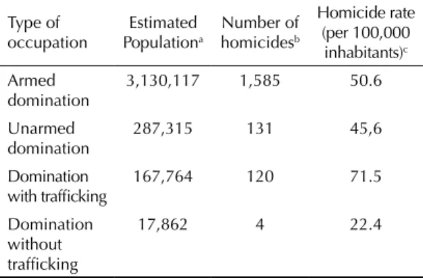
In the radius up to 250 m from favelas with a presence of armed groups, the estimated murder rates, based on data from the SIM, are slightly higher than in disarmed areas (45/100,000 inhabitants). The biggest differ -ences are found when comparing areas with drug traf-icking, which present rates up to three times higher than the favelas without traficking. Likewise in the areas where the CV was recently expelled, principally in the Complexo do Alemão, the rate of 26.8/100,000 inhabitants is considerably lower than the municipal-ity’s average (52/100,000 inhabitants).
The GIS was used to calculate distances between favelas close to the place of occurrence of the aggression that led to the homicide, based on data from the ISP. From a total of 3,260 homicides among residents in the munici-pality, 1,093 took place in the areas close to at least two favelas. The areas situated between favelas under the same control, i.e. both controlled by CV, showed a higher number of homicides: 386. At the same time, the areas of potential conlict between territories, i.e., bordering two favelas controlled by different groups, showed 355 homicides, which is not a small number given that these areas of interface are rarer and smaller. These homicides are more frequent in areas close to the areas controlled by the CV and militias. Where militias only are found, 219 homicides were registered.
One example of this kind of conlict is found in Rio’s western zone, in the district of Fazenda Botafogo. Figure 3 shows the occurrence of homicides in this area where groups like the CV, ADA and militias control favelas situated very close to each other. This region also contains large warehouses belonging to household appliance companies, whose trucks are a constant target for robberies.23 As a result militias have also been installed there, making the area even more conlict-ridden.25
Violent acts resulting in homicides also occur within the favelas, according to data from the ISP. However these are mainly concentrated around the local corri-dors where people circulate. These corricorri-dors form contact zones between the different groups where armed conlicts are frequent, as well as place where the bodies of executed people are ‘unloaded.’
These data indicate the importance of the ight for terri -tories among the different groups in the promotion of violence. On the other hand, large areas controlled by the same armed groups do not ensure the absence or reduction of homicides. These corridors, even among favelas under the same control, are areas of potential ights between subgroups and violence perpetrated against traders and residents as a strategy for main-taining power over the territory.
DISCUSSION
These analyses demonstrate that living in favelas does not represent, by itself, an excess risk of homicide. This risk is determined by the occupational dynamic of these territories and the presence of irearms and criminal groups, especially those linked to illegal drug traficking. Territorial disputes are altering the spatial coniguration of drug traficking in Rio de Janeiro, with important consequences on homicide rates. The conlict zones, where favelas are located next to supply centres, ports and airports, or where rival criminal factions live in close proximity, demonstrate higher rates.
The main changes in territorial control have occurred in the city’s southern and northern zones due to the occu-pation of these areas by the UPP, and in the western zone following the takeover of favelas by the militias.22 Until 2005 the militias were conined to the eastern zone, more recent areas of urban settlement with lower demo-graphic density and a high percentage of northeastern migrants among their residents. By 2010 the militias had expanded to other areas of the so-called suburbs, but not to the favelas close to city’s main avenues. The only favelas to have remained under the control of the CV in the western zone in 2009 were located in Cidade de Deus. In the southern zone of the city, more pros-perous with high-income families, none of the favelas was controlled by the militias. The restriction on the areas in which the militias are active may be a conse-quence of the city’s morphology, relecting the obsta-cles to circulation imposed by the mountains and sea, in contrast to the lat-lying western zone, which perhaps facilitates the movement of the paramilitaries. Another hypothesis, based on previous research studies, is that many of the security companies in the wealthier parts of the city, both uniformed and plain clothed, belong to police oficers and also act as ‘militias’ in poor areas. The big difference resides in the relation between the security personnel and local residents. In poor areas, the
Table. Estimated population, number of homicides according
to place of residence of the victim and homicide rates by type of activity in the near surroundings of favelas in Rio de Janeiro, RJ, 2009.
Type of occupation Estimated Populationa Number of homicidesb Homicide rate (per 100,000 inhabitants)c Armed domination
3,130,117 1,585 50.6
Unarmed
domination 287,315 131 45,6 Domination
with trafficking
167,764 120 71.5
Domination without trafficking
17,862 4 22.4
a IBGE. Census, 2010.
lack of access to justice means it is easier for the private security agents to become tyrants or negotiators who impose extralegal or illegal decisions on residents due to the power derived from their use of irearms, forcing robbers and drug dealers to leave the area.
The presence of drug traficking, especially armed drug traficking, increases the homicide rates around the favelas. Many of these killings arise from armed conlicts between dealers from different gangs, between the latter and the police, or between drug trafickers and militia forces over the conquest or defence of territo-ries or the payment of debts and bribes. Carrying ire-arms, for its part, is explained by the sociocultural context of the small groups to which the young people belong, who adhere to the values and practices of this street culture. Some studies, particularly in the United States, identify the peer group as the biggest predictive factor for delinquency among young males, especially more serious violent crimes and the habit of bearing irearms.14 Other studies conclude that carrying guns
and repeating years at school are the most important predictors of violence for youths. The rise in the homi-cide rate is better explained by the high concentration of guns where impoverished young men live than by any natural inclination towards violence.
The high homicide rates found in the areas immediately adjacent to favelas may have two non-exclusive expla-nations. Locating residence addresses inside favelas is very dificult. The informal street and building layout very often prevents the localization of addresses in small roads and alleys within the favelas. One strategy adopted by residents is to provide addresses from the neighbouring area, such as the ofices of resident asso -ciation, stores and other local points of reference in these formal urban areas. This means that the addresses declared in the information systems maintained by the public security and health services actually refer to locations in the areas around the favelas, artiicially increasing the risks estimated for these areas.
A second explanation is the ampliication of the conlicts on the favela borders. The increase in homicide rates in nearby areas may stem from the territorial conlicts between criminal groups and the drug trafickers’ prohi-bition of armed robbery inside the favela, although they accept guns and money from thieves. These practices are very common in Brazilian cities where armed drug traf-ickers occupy and defend their territories.
The control of favelas by UPP or militias apparently reduces the risks of mortality by violence. In recent years there has been a considerable growth in this type of
Location of homicide Favelas according to the control of criminal groups
ADA CV Militia TCP
ADA: Amigos dos Amigos; CV: Comando Vermelho; TCP: Terceiro Comando Puro; UPP: Police Pacification Units Source: IBGE – Demographic census 2010 – areas surveyed within the scope of this research.
occupation of Rio’s favelas. Preliminary estimates allow us to identify a tendency for residents to be protected when the favela is under the supervision of an UPP.
The militia-controlled areas show lower rates of mortality by violence than areas controlled by armed drug gangs. The strategy for occupying these areas could explain this difference. The militias do not occupy the favelas only, but their entire surrounding area, which becomes a lucrative source of income through the legal or illegal trade in goods and services like transportation, electricity, water and leisure activi-ties. Furthermore, the militias also employ other forms of coercing residents, like expelling people linked to drug traficking, collecting irearms, torturing people who commit crimes deemed unacceptable, and so on.
Spatial analysis techniques allow us to evaluate the risk conditions of vulnerable populations, comprehending
the favelas not as a homogenous sociospatial phenom-enon, but in terms of their different forms of occupa-tion and acoccupa-tions by armed groups. The analysis has allowed the hypothesis that territorial control by drug gangs and the presence of armed groups increase the risks of death by violence to be conirmed.
1. Barcellos C, Ramalho WM, Gracie R, Magalhães MAFM, Fontes MP, Skaba D. Georreferenciamento de dados de saúde na escala submunicipal: algumas experiências no Brasil. Epidemiol Serv Saude. 2008;17(1):59-70.
2. Beato Filho CC, Assunção RM, Silva BFA, Marinho FC, Reis IA, Almeida MC. Conglomerados de homicídios e o tráfico de drogas em Belo Horizonte, Minas Gerais, Brasil, de 1995 a 1999. Cad Saude Publica. 2001;17(5):1163-71. DOI:10.1590/S0102-311X2001000500017
3. Burawoy M. The extended case method. Sociol Theory. 1998;16(1):4-33. DOI:10.1111/0735-2751.00040 4. Cano I, Santos N. Violência letal, renda e desigualdade
social no Brasil. Rio de Janeiro: 7 Letras; 2001. 5. Castro MSM, Assunção RM, Durante MO.
Comparação de dados sobre homicídios entre dois sistemas de informação, Minas Gerais.
Rev Saude Publica. 2003;37(2):168-76. DOI:10.1590/S0034-89102003000200002 6. Chainey S, Ratcliffe J. GIS and crime mapping.
London: John Wiley & Sons; 2005.
7. Dowdney L. Crianças no tráfico: um estudo de caso de crianças em violência armada organizada no Rio de Janeiro. Rio de Janeiro: 7 Letras; 2003.
8. Ellikson P, Saner H, McGuigan KA. Profiles of violent youth: substance use and other concurrent problems.
Am J Public Health. 1997;87(6):985-91.
9. Fagan J. Policing guns and youth violence. Future Child. 2005;12(2):133-51.
10. Gawryszewski VP, Costa LS. Social inequality and homicide rates in Sao Paulo City, Brazil.
Rev Saude Publica. 2005;39(2):191-7. DOI:10.1590/S0034-89102005000200008
11. Iyer S, Monteiro MFG. The risk of child and adolescent mortality among vulnerable populations. J Biosoc Sci. 2004;36(5):523-46.
12. Melgaço LM. Uso do território pela violência. In: Souza MA, organizadora. Território brasileiro: usos e abusos. Campinas: Edições Territorial; 2003. v.1, p.524-33.
13. Misse M. La acumulación social de la violencia en Rio de Janeiro y en Brasil: algunas reflexiones. Co- Herencia. 2010;7(13):19-40.
14. Myers GP, McGrady GA, Marrow C, Mueller CW. Weapon carrying among black adolescents: a social network perspective. Am J Public Health. 1997;87(6):1038-40.
15. Resnick MD, Ireland M, Borowsky I. Youth violence perpetration: what protects? What predicts? Findings from the National Longitudinal Study of Adolescent Health. J Adolesc Health. 2004;35(5):424.e1-424.e10. DOI:10.1016/j.jadohealth.2004.01.011
16. Rojas LI; Santos SM; Barcellos C. Diferenciación espacial de la violencia en America Latina. In: Minayo MCS, Coimbra Jr CEA, organizadores. Críticas e atuantes: ciências sociais e humanas em saúde na América Latina. Rio de Janeiro: Editora. Fiocruz; 2005. p.665-86.
17. Santos M. A natureza do espaço: técnica e tempo, razão e emoção. São Paulo: Hucitec; 1996. 18. Santos SM, Barcellos C, Sá Carvalho M.
Ecological analysis of the distribution and socio-spatial context of homicides in Porto Alegre, Brazil. Health Place. 2006;12(1):38-47. DOI:10.1016/j.healthplace.2004.08.009 19. Soares Filho AM. Homicide victimization
according to racial characteristics in Brazil.
Rev Saude Publica. 2011;45(4):745-55. DOI:10.1590/S0034-89102011005000045 20. Szwarcwald CL, Bastos FI, Esteves MA, Andrade
CLT, Paez MS, Medici EV, et al. Desigualdades de renda e situação de saúde: o caso do Rio de Janeiro. Cad Saude Publica. 1999;15(1):15-28. DOI:10.1590/S0102-311X1999000100003
21. Taquette S, Caldas CP, organizadoras. Ética e pesquisa com populações vulneráveis. Rio de Janeiro: Editora da Universidade do Estado do Rio de Janeiro; 2012. pág. 46
22. Zaluar A, Barcellos C. Mortes prematuras e conflito armado pelo domínio das favelas no Rio de Janeiro. Rev Bras Cienc Soc. 2013;28(81):17-31. DOI:10.1590/S0102-69092013000100002
23. Zaluar A. Turf war in Rio de Janeiro: youth, drug traffic, guns and hyper-masculinity. In: Ceccato V, editor. The urban fabric of crime and fear. New York: Springer; 2012. v.1, p.217-38.
24. Zaluar A. Violence in Rio de Janeiro: styles of leisure, drug use, and trafficking. Int Soc Sci J. 2001;53(3):369-78.
25. Zaluar AM, Conceição IS. Favelas sob o controle das milícias no Rio de Janeiro: que paz? Sao Paulo Perspect. 2007;21(2):89-101.
26. Zaluar AM. Pesquisando no perigo: etnografias voluntárias e não acidentais. Mana. 2009;15(2):557-84. DOI:10.1590/S0104-93132009000200009
REFERENCES