MAPPING POTENTIAL ECONOMIC LOSSES FROM FLOOD POINTS
IN THE MUNICIPALITY OF SÃO PAULO, 2008-2012
1
ELIANE TEIXEIRA DOS SANTOS2
EDUARDO AMARAL HADDAD3
Introduction
Flooding in the city of São Paulo has become part of the routine of its citizens. Every year, particularly in summer, the lives of families, employees and businesspeople are affected by the disruptions and inconvenience caused by excessive rain. Despite uncertainty regarding long-term climate projections, recent studies have pointed to an increase in the frequency and intensity of rain in the municipality of São Paulo. The effects of climate change, associated to changes in land use due to the intense process of urbanization observed in the city, not founded on adequate urban planning, means that society becomes exposed and vulnerable, increasing the risk of natural disasters.
This article presents an extension of the work carried out by Haddad and Teixeira (2014) who assessed the economic impacts of floods in São Paulo. It takes into account a more extensive concept of damages which not only includes the direct losses which are traditionally associated to the interruption of production, but also the indirect costs obtained by accounting for the production chains involving the city. This work represents a first attempt to analyze this issue using an integrated modelling approach.
Direct losses were estimated by considering the interruption of economic activities in the areas affected by floods. The firms which were likely to be affected were identified by overlapping layers of information about floods with the profile of firms, within a pre-defined radius of impact. Indirect losses were estimated by using a Spatial Computable General Equilibrium (SCGE) model, based on the simultaneous optimization of consumer and firm behavior in a multi-regional structure which can capture the spatial, or geo-graphical, distribution of impacts. This model estimated the change in output if flooding had not taken place. Results indicated that flooding in the city of São Paulo reduced the Gross Domestic Product (GDP), the well-being of São Paulo’s consumers and the
1. The authors acknowledge financial support provided by Rede CLIMA and INCT-MC. Eduardo A. Haddad also acknowledges financial support from CNPq and FAPESP; he thanks Princeton University and Rutgers University for their hospitality.
city’s tax revenue, as well as those of the Metropolitan Region (SPMR), the state and the country, showing that a seemingly local problem can have effects beyond the city’s limits. Furthermore, a loss in competitiveness was also observed at the city level not only in domestic markets but also in international markets.
In addition to macroeconomic impacts, the integrated modelling strategy devel-oped by Haddad and Teixeira (2014) enabled the identification of the city’s economic hotspots or flood points which can potentially result in some of the largest economic losses for the city of São Paulo and Brazil. The aim of this article is to estimate direct and indirect losses of each flood point and provide a useful tool for assessing the cost-benefit of structural works to reduce flooding, so as to assist in the decision-making of urban planners.
Urbanization and Natural Disasters
iThe problem of floods in the city of São Paulo is strongly associated to climate chan-ge, urbanization and natural disasters. Recently, the relationship between the urbanization of large agglomerations and flooding has received closer attention due to the forecasts of change in the frequency and intensity of extreme events associated to climate change (NOBRE et al., 2011; LINNEKAMP et al., 2011; GU et al., 2011) and the likelihood of natural disasters, given the susceptibility of urban areas (SUAREZ et al., 2005).
One of the main concerns of contemporary society with regard to climate forecasts relates to potential changes in the frequency and intensity of short-duration extreme weather events. Amongst the most alarming extreme events affecting the city of São Paulo are those related to intense rainfall. Specialists forecast an increase in the number of days with heavy rainfall to the end of the century (IPCC, 2012; SHEPHERD et al., 2002; MARENGO et al., 2009; NOBRE et al., 2011; SILVA DIAS et al., 2012). Prelimi-nary studies suggest that between 2070 and 2100, the average increase in the region’s temperature, between 2°C and 3°C, could double the number of days with heavy rainfall in the municipality of São Paulo’s region (NOBRE et al., 2011).
Severe wet weather events have a significant impact on society, given that flooding associated to short and frequent periods of excessive rain can be the most destructive type of extreme event in large urban centres. The IPCC forecasts (2007, p. 53) for the end of the 21st century on the altered patterns of extreme events due to climate change also reveal an increase in the incidence of heavy rainfall in most regions in the planet, for all emission scenarios.
Despite the uncertainty present in climate forecasts, recent studies have already re-vealed both higher intensity and frequency of rainfall in the city of São Paulo. Throughout most of the 20th century, there were very few days when rainfall exceeded 80 millimetres per day in São Paulo - from the 1930s onward, the average was an event per decade. However, since the 1970s, the number of this type of event has increased, reaching nine cases during the first decade of the 21st century (SILVA DIAS et al., 2012). Furthermore, high urban density is a significant source of heat. The densest parts of the metropolitan region tend to be warmer. By contrast, temperature decreases as urban density declines (SHEPHERD et al., 2002). This fact supports forecasts on the increase in the frequency and intensity of days of extreme rainfall in the city of São Paulo (SILVA DIAS et al., 2012).
There is significant correlation between human occupation and urban draining
systems (OSTROWSKY, 1991; NOBRE et al., 2011). Urban development promotes
changes in land use which increase the risk of floods, such as (i) changes in the flow of canals which may restrict drainage during strong rainfall events (KONRAD; BOOTH, 2002), (ii) excessive sealing of soil surfaces which interfere with the city’s water dynam-ics, and (iii) soil occupation over canalized rivers and streams, intensifying silting and altering river flow patterns. Megacities such as São Paulo have a number of social and environmental problems which are linked to its patterns of spatial development and transformation. These problems are aggravated by the frequency and intensity of rainfall.
Extreme weather events are frequently, though not always, associated to natural disasters which have social, economic and environmental implications and seriously disrupt the normal functioning of communities affected. Meteorological conditions and extreme weather events may result in natural disasters if, and only if: (1) communities are exposed to these events and (2) their exposure is accompanied by a high level of vulner-ability (IPCC, 2012). Thus, natural disasters may also be triggered by events which are not considered extreme in a statistical sense. High levels of exposure and vulnerability will transform even smaller events into disasters in some societies.
The city of São Paulo aggregates all the factors which make it susceptible to natu-ral disasters, defined as the likelihood of a natunatu-ral physical or induced event which may cause adverse effects on exposed and vulnerable elements, such as loss of life, physical damage, and loss to property and infrastructure (UNITED NATIONS, 2010). The accel-erated pace of urban expansion was not accompanied by the implementation of adequate infrastructure. This has caused significant urban problems such as illegal occupation of protected environmental areas (around watercourses and hillsides) and the rapid growth of sealed areas in the basin of the Alto Tietê, through where the city’s main river flows. Consequently, the frequency of floods in this basin (the natural disaster affecting the city every year) has also increased (BARROS et al., 2005). All these changes affect the environment making human settlements increasingly vulnerable and exposed to climate change, resulting in the need to adapt to alterations recorded over time.
state and national levels. Floods affect families, industrial and commercial activities, public and private services and the urban transport system. Given the growing concentration of people and economic activities in the region during the last decades, impacts and economic losses related to natural disasters have substantially increased.
The economic consequences of urban floods are very significant because they affect human health (HUNTINGFORD et al., 2007), the value of properties (HARRISON et al., 2001) and the urban transport infrastructure (SUAREZ et al., 2005). In addition, other negative effects are a loss of work and study time, damage to properties and psychologi-cal stress (LINNEKAMP et al., 2011). Furthermore, financial costs are also significant due to their potential effect on the insurance sector and public compensation schemes (BOTZEN; VAN DEN BERGH, 2008).
Economic Hotspots
Economic vulnerability to floods must be considered as a function of (i) dependency - the degree to which an activity is related to other economic activities in the rest of the country; (ii) resilience - the ability of an activity (or system) to overcome dependency and respond to ruptures, using substitutes or relocation; and (iii) susceptibility - the proba-bility and extension of floods (VAN DER VEEN, LOGTMEIJER, 2005). Understanding this tripod is essential to identify the risks related to economic hotspotsii associated to a
broader concept of loss which should include not only the traditional direct losses related to infrastructure, property and the interruption of production, but also indirect costs measured by taking into account input-output chains.
In this study, the concept of hotspots was used within an alternative methodologi-cal approach. It focused on a specific dimension of the economic impacts of floods in an integrated inter-regional system. Initially, all incidences of floods in the city of São Paulo which occurred in 2008 were considered (the same year for which there were economic data available). Given that all flood events which took place in that year were analyzed, it was less important to address susceptibility. From the economic point of view, once flooding occurred in particular points in the city, it was important find out which firms were affected within these points. The other two elements were also analyzed in detail. Dependency was fully captured by spatial links associated to income flow and value chains incorporated into the metropolitan input-output system used to calibrate the SCGE model; it was also considered through the modelling of inter-regional factor mobility. Resilience was estimated with regard to the strength of substitution factors induced by price and supply restrictions in the model.
stimulat-ing investment activities (such as the civil construction sector) which are strengthened in periods of flooding.
This study assesses the effects of the first of these three forces at work - the tempo-rary stoppage of production and the consequent interruption in the value chain. Building on the work of Haddad and Teixeira (2014) which estimated the potential impact on the economy of no flood points in the city during that year, we identified the contribution of each flood point to the total impact.
In this context, economic hotspots are referred to as the flood points which are likely to have brought the worst economic losses for the city of São Paulo, providing a measure of the scale of losses in geographical terms.
The integrated modelling strategy enabled the identification of firms affected in each flood point within a pre-defined radius of impact. Total losses were estimated using information on direct losses by using the SCGE model. In this way, the total impact on production was assessed not only in terms of direct but also of indirect losses caused by interruption in the long production chains linking the city of São Paulo to its metropolitan region, the state of São Paulo and the rest of the country (see Haddad and Teixeira, 2014).
By using decomposition techniques, it was possible to obtain estimates of the poten-tial losses for each flood point applying sectorial impact multipliers. Applying multipliers to direct individual losses enabled us to obtain estimates of the total economic losses for each point. Impact multipliers were obtained as follows:
Where:
• Total Potential Lossyrs is total potential loss estimate resulting from the SCGE model per year y, region r and sector s;
• Shock Vectorys is the shock vector representing direct losses in terms of the reduc-tion in value added for year y and sector s.
Sectors (s) considered in the analysis are the eight sectors in the SCGE model; the research period (y) encompassed 2008 to 2012.
Figure 1: Economic Hotspots - 2008
Source: Produced by authors, based on Geographic Information System
The hotspots spatial pattern suggests that flood point areas causing the greatest losses to the city refer to the main distribution corridors related to export flows from the city. Figure 2 was obtained from the Land Use and Occupation Atlas of the Municipal-ity of São Paulo, developed by EMPLASAiii. The areas in red represent urbanized areas
Figure 2: Land use and occupation in the Municipality of São Paulo, EMPLASA (2006)
Source: EMPLASA
Assuming that the economic production structure in São Paulo remained the same between 2008 and 2012, it is possible to extrapolate results and estimate the potential output losses per flood point for the period. These estimates enable us not only to observe the potential changes in the geographical patterns of flood distribution, but also to expand the study’s scope to include a cost-benefit analysis of “anti-flood” works implemented by the new administration of the city of São Paulo.
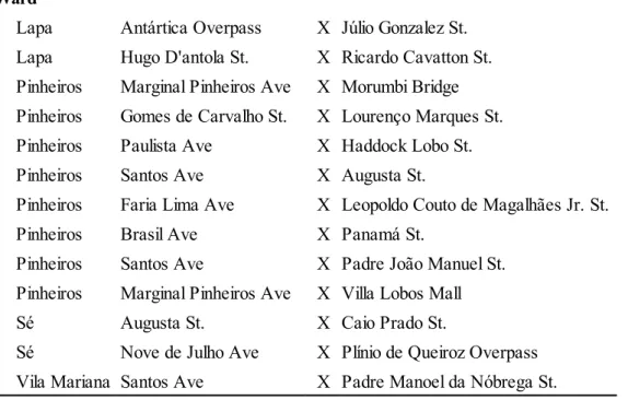
The list of hotspots which have caused potential losses of over R$20 million per year, in the last five years, is shown in Table 1. It is worth pointing out that information on flooding made available by the São Paulo Emergency Management Center - CGE - is gathered by the Traffic Engineering Company (CET), which monitors the main traffic corridors in the expanded centre of the city of São Paulo to a better degree than other areas. Therefore, the concentration of points in this region does not mean that only this area is affected by flooding problems, rather, that there is no information available for other regions of the city due to lack of monitoring.
Table 1: Hotspots presenting the biggest loss potential in the last five years (2008–2012)
Ward
Lapa Antártica Overpass X Júlio Gonzalez St.
Lapa Hugo D'antola St. X Ricardo Cavatton St.
Pinheiros Marginal Pinheiros Ave X Morumbi Bridge
Pinheiros Gomes de Carvalho St. X Lourenço Marques St.
Pinheiros Paulista Ave X Haddock Lobo St.
Pinheiros Santos Ave X Augusta St.
Pinheiros Faria Lima Ave X Leopoldo Couto de Magalhães Jr. St.
Pinheiros Brasil Ave X Panamá St.
Pinheiros Santos Ave X Padre João Manuel St.
Pinheiros Marginal Pinheiros Ave X Villa Lobos Mall
Sé Augusta St. X Caio Prado St.
Sé Nove de Julho Ave X Plínio de Queiroz Overpass
Vila Mariana Santos Ave X Padre Manoel da Nóbrega St.
Source: Study results
Marginal benefits of “anti-flood” works
exclusion, according to which individuals, who do not want to - or cannot - pay for the cost of particular goods and services, can be excluded from consuming these items.
The principle of exclusion is a necessary condition for the conventional market to operate efficiently. When these conditions do not apply, goods and services become public goods. The provision of public goods by the private sector is hard to implement, given that their cost-benefit analysis is complex and because of the difficulties involved in restricting their use (making these exclusive). Thus funding these goods in this way is almost impossible. Given the lack of exclusion conditions, the problem of losses caused by floods requires public intervention (KRUTILLA, 1966).
Considering the nature of flooding issues, sharing of responsibility for reducing losses caused by floods between local and federal authorities seems to be based on misle-ading assumptions. Whilst local governments are responsible for preventing floods of a moderate volume which are relatively regular, the federal government is liable for disasters associated to large volumes which occur less frequently.
Despite being an apparently local phenomenon, the analysis by Haddad and Teixeira (2014) shows that the impact of floods in the city of São Paulo (moderate volumes and regular occurrence phenomena) is felt beyond the city. However, recognizing that the economic effects of floods are not only local has governance implications for the Brazilian federal context. Given that decisions (and budgetary control) are taken at the municipal, state and federal levels, it is important to address co-ordination issues. As Biesbroek et al. (2009) show, there is no right solution to the challenges produced by climate change, given that they require joint efforts in the long-term and decisions taken in the short-term at all levels of government. Within the context of floods in São Paulo an extra challenge emerges. In addition to the traditional administrative structure to which urban planners are accustomed - and which favours the solution of socio-economic issues - additional geographical layers are required (such as the river basin and climate) bringing in new dimensions which must be integrated in the search for solutions.
What are the marginal benefits of the “anti-flood” works carried out in the muni-cipality of São Paulo? Are the benefits per unit of currency invested on flood prevention greater than their marginal costs? Are the externalities of these works for the economies of the city and the country positive or negative?
Table 2: Potential GDP losses (in R$ million) - 100 meters radius impact scenario
2008 2009 2010 2011 2012 Average
Direct Losses
São Paulo city 35.5 69.2 52.1 40.7 63.7 52.3
Total Losses
São Paulo city 75.3 130.3 86.5 97.5 149.0 107.7
Other cities in the SP Metropolitan Region 6.9 6.1 3.4 3.8 2.2 4.5
Remainder of SP state 15.2 19.3 13.7 13.4 22.5 16.8
Rest of Brazil 73.3 110.8 82.0 81.3 137.5 97.0
Brazil 170.6 266.5 185.5 196.0 311.2 226.0
Intercity Losses Rate 2.1 1.9 1.7 2.4 2.3 2.1 Total Losses Rate 4.8 3.8 3.6 4.8 4.9 4.3
Source: Study results
The new administration of the city of São Paulo established that the Municipal Department for Urban Infrastructure and Works (SIURB) would be responsible for micro-drainage “anti-flood” works. A budget of R$ 150 million was approved to carry out works across the city. The purpose of these works was to contribute to faster runoff in seventy-nine critical points in the city, preventing the formation of flood points which hinder traffic flow. The implementation stage was set to last six months. Comparing the average potential losses for Brazil in a single year (approximately R$ 226 million) with the cost of investing in “anti-flood works”, it is already possible to state that benefits exceed costs, both in strictly economic, as well as in social terms, when considering the well--being that flood reduction would bring. However, the amount of potential losses relate to all flooding points in São Paulo in the last five years. For a more detailed cost-benefit analysis, it is important to bring this research to the local level.
An example is the local analysis conducted in relation to the works carried out as part of Operação Água Brancaiv, involving structural macro-drainage works in the regions
occupied by the natural valleys of the Tietê River. R$ 143 million would be invested for a period of 33 months using funds raised from business ventures established in the region between 1995 and 2013. The purpose of these works is to solve the problems of a particular locality resulting in output losses in the sub-administrative ward of Lapa.
potential output loss may have reached R$ 38 million per year in the region covered by this operation.
Figure 3: Potential GDP losses in the São Paulo wards during 2008
Supposing that floods in the region covered by Operação Água Branca were reduced by 90%, cost savings would amount to R$35 million a year, once works are completed. In a simple back-of-the-envelope calculation, estimating the period of durationv for the
reduction of economic losses caused by floods, the losses prevented could amount to R$ 560 million, estimating only the costs incurred in the city of São Paulo (not taking into account its effects along the long production and income chains). Moreover, considering the social benefits provided by this investment, it can be justifiable both in economic and social terms.
Final Considerations
From the beginning of the 1970s there has been an increase in the number of days in which precipitation exceeded 80 mm/day in the city of São Paulo. According to forecasts, the frequency of heavy rainfall events in the region will continue to grow. The combination of the location of flood points and that of firms within a Geographic Infor-mation System enabled us to estimate the economic impact of floods occurring in the city in 2008 (Haddad and Teixeira, 2014). It is estimated that floods negatively affected the economic growth of the city and the well-being of its residents. It also had a negative impact on the competitiveness of the city within both the domestic and international markets. This not only affected the economic performance of the city itself, but the economies of other regions in Brazil.
This work complements the study conducted by Haddad and Teixeira (2014), enabling us to break down global results and identify potential losses per flood point, expanding the scope of the original analysis. This new set of data enabled economic hotspots to be identified, that is, it identified the points which have caused the largest potential economic losses for the city of São Paulo and Brazil as a whole. Furthermore, the decomposition technique employed is a tool which can be used to evaluate the eco-nomic benefits of local flood reduction projects. The analysis of Operação Água Branca showed that benefits from corrective or preventive measures can outweigh the costs of investments. The optimization of expenditure in the area of infrastructure, with appropri-ate focus on geography, would enable surplus resources to be redirected to other areas of social interest such as health, education, urban mobility and security.
Notes
i This section draws on Haddad and Teixeira (2014).
ii Hotspots are measures of the intensity of a phenomenon. The term economic hotspots is used here to refer to the measure of the intensity of economic losses within the geographical space.
iii EMPLASA – The São Paulo State Company for Metropolitan Planning
iv The Operação Água Branca (Law 11.774 from 18 May 1995) encompasses part of the districts of Água Branca, Perdizes and Barra Funda (São Paulo Municipality’s site, http://www.prefeitura.sp.gov.br. Accessed on 05/09/2013).
v Perpetuity (P) is a series of infinite payments or deposits. In this case, we consider as payment (R) the marginal benefits of “anti-flooding” works, that is, the potential loss the city of São Paulo will stop incurring each year. Perpetuity is calculated as P = R/i , where i is the real interest rate calculated on the basis of the Long Term Interest Rates (LTIR) for September 2013 (11%) within the inflation target of the monetary agency (4.5%).
References
BARROS, M. T. L. et al.. The impact of urban sprawl on flood risk areas. In: MOGLEN, Glenn E.. Managing watersheds for human and natural impacts: engineering, ecological, and economic challenges. Williamsburg, VA: American Society of Civil engineers, 2005.
BIESBROEK, G. Robert et al.. The mitigation-adaptation dichotomy and the role of spatial planning. Habitat International. [S.l.]: Elsevier, v. 33, p. 230-237, 2009.
BOTZEN, W. J. W.; VAN DEN BERGH, J. C. J. M.. Insurance Against Climate Change and Flooding in the Netherlands: Present, Future, and Comparison with Other Countries. Risk Analysis. [S.l:s.n], v. 28, p. 413–426, 2008.
DINIZ, C. C.. Polygonized development in Brazil: neither decentralization no continued polarization. International Journal of Urban and Regional Research. [S.l.:s.n], v. 18, n.2, p. 293-314, 1994.
GROSTEIN, Marta Dora. Metrópole e expansão urbana: a persistência de processos “insustentáveis”. São Paulo em Perspectiva. São Paulo: [s.n], v. 15, n.1, p. 13-19, 2001. GU, Chaolin et al.. Climate change and urbanization in the Yangtze River Delta. Habitat International. [S.l.]: Elsevier, v. 35, p. 544-552, 2011.
HADDAD, Eduardo A. Regional inequality and structural changes: lessons from the Brazilian economy. Aldershot: Ashgate, 1999.
HADDAD, Eduardo A.; HEWINGS, Geoffrey J. D. Market imperfections in a spatial economy: some experimental results. The Quarterly Review of Economics and Finance. [S.l.]: Elsevier, v. 45, n. 2, p. 476-496, 2005.
HADDAD, Eduardo A., et al., Impactos Econômicos das Mudanças Climáticas no Brasil.
In: Anais do XIV Seminário sobre a Economia Mineira. 2010.
HARRISON, David M. et al. Environmental determinants of housing prices: the impact of flood zone status. The Journal of Real Estate Research. [S.l.: s.n.], v. 21, n. 1/2, p. 3-20, 2001.
HEWINGS, Geoffrey J.D.; MAHIDHARA, Ramamohan. Economic impacts: lost income, ripple effects and recovery. In: CHANGNON, Stanley (Org.). The great flood of 1993: causes, impacts and responses. Boulder: Westview Press, 1996.
HEWINGS, Geoffrey J. D.; OKUYAMA, Yasuhide; SONIS, Michael. Economic interdependence within the Chicago Metropolitan region: a Miyazawa analysis. Journal of Regional Science. [S.l.]: Blackwell Publishers, v. 41, n. 2, p. 195-217, 2001.
HUNTINGFORD, C. et al.. Impact of climate change on health: what is required of
climate modellers?. Transactions of the Royal Society of Tropical Medicine and
Hygiene. [S.l.]: Elsevier, v. 101, p. 97-103, 2007.
ICHIHARA, Silvio Massaru. O uso combinado dos modelos de insumo-produto e
técnicas de geoprocessamento. Piracicaba: Universidade de São Paulo, 2007.
INTERGOVERNMENTAL PANEL ON CLIMATE CHANGE (IPCC). Climate change
2007: Synthesis Report. Valencia. 12-17 Nov. 2007.
INTERGOVERNMENTAL PANEL ON CLIMATE CHANGE (IPCC). Managing the
risks of extreme events and disasters to advance climate change adaptation: a special report of working groups I and II. Cambridge: Cambridge University Press, 2012. JUN, Myung-Jin. A metropolitan input-output model: multisectoral and multispatial relations of production, income formation, and consumption. Annals of Regional Science. [S.l.]: Springer, v. 38, p. 131-147, 2004.
KONRAD, C. P.; BOOTH, D. B.. Hydrologic trends associated with urban development for selected streams in the Puget Sound Basin, Western Washington. U.S. Geological Survey, Water-Resources Investigations Report 02-4040. Disponível em: <http://pubs. usgs.gov/wri/wri024040/>. Acesso em: 20/08/2013.
KRUTILLA, John V., An Economic Approach to Coping with Flood Damage. Water
Resources Research. Washington, D.C.: Resources for the Future, v.2, n.2, p. 183-190, 1966.
LINNEKAMP, F. et al.. Household vulnerability to climate change: Examining perceptions of households of flood risks in Georgetown and Paramaribo. Habitat International. [S.l.]: Elsevier , v. 35, p. 447-456, 2011.
MARENGO, J. A. et al.. Future change of temperature and precipitation extremes in South America as derived from the PRECIS regional climate modeling system. International Journal of Climatology. [S.l.]: Royal Meteorological Society, v. 29, p. 2241 – 2255, 2009.
MCDONALD, John F.; MACMILLEN, Daniel P.. Urban Economics and Real Estate:
Theory and Policy. [S.l]: Blackwell Publishing., 2007.
OKUYAMA, Yasuhide. Economic modeling for disaster impact analysis: past, present, and future. Economic Systems Research. [S.l.]: Routledge , v. 19, n. 2, p. 115-124, 2007.
OSTROWSKY, Maria de S. B.. Urbanização e controle de enchentes: o caso de São Paulo. São Paulo: Universidade de São Paulo, 1991.
ROSE, Adam. Economic principles, issues, and research priorities in hazard loss estimation.
In: OKUYAMA, Yasuhide; CHANG, Stephanie E.. Modeling spatial and economic
impacts of disasters. New York: Springer, 2004.
ROSE, Adam; LIAO, Shu-Yi. Modeling regional economic resilience to disasters: a computable general equilibrium analysis of water service disruptions. Journal of Regional Science. Malden: Blackwell, v.45, n. 1, p. 75-112, 2005.
SHEPHERD, J. Marshall et al.. Rainfall modification by major urban areas: observations from spaceborne rain radar on the TRMM satellite. Journal of Applied Meteorology. [S.l.]: American Meteorological Society, v. 41, p. 689-701, 2002.
SILVA DIAS, Maria A. F. et al.. Changes in extreme daily rainfall for São Paulo, Brazil.
Climatic Change.[S.l.]: Springer, v. 116, p. 705-722, 2012.
SUAREZ, Pablo. et al.. Impacts of flooding and climate change on urban transportation: A systemwide performance assessment of the Boston Metro Area. Transportation Research. [S.l.]: Elsevier, v. Part D 10, p. 231-244, 2005.
UNITED NATIONS, The; WORL BANK, The. Natural hazards, unNatural disasters:
the economics of effective prevention. Washington DC: [s.n.], 2010.
VAN DER VEEN, Anne; LOGTMEIJER, Christiaan. Economic Hotspots: Visualizing Vulnerability to Flooding. Natural Hazards. [S.l.]: Springer, v. 36, p. 65-80, 2004.
Submitted on: 27/02/2014. Accepted on: 04/08/2014
Abstract: This article presents an extension of the work by Haddad and Teixeira (2014) in which they assessed the economic impacts of flooding in Sao Paulo considering a broader concept of economic loss, which includes not only traditional direct losses related to the interruption of production, but also the indirect costs associated with value chains. The overall results were decomposed enabling the identification of potential losses by speci-fic flood points, expanding the scope of the analysis. With this new set of information, economic hotspots were identified, in other words, the points that may have caused the greatest potential economic losses to the city of São Paulo and the country. Moreover, the decomposition technique used provides an auxiliary tool for cost-benefit analysis of local projects to reduce flooding.
Keywords: Impact analysis; Floods; Climate change; São Paulo.
Resumo: Este artigo apresenta uma extensão do trabalho de Haddad e Teixeira (2014) em que se avaliaram os impactos econômicos dos alagamentos em São Paulo considerando-se um conceito mais amplo de prejuízo, que inclui não só as perdas diretas tradicionais rela-cionadas à interrupção da produção, mas também os custos indiretos avaliados por meio das ligações das cadeias produtivas em que a cidade se insere. Os resultados globais foram decompostos possibilitando a identificação das perdas potenciais por ponto de alagamento, ampliando o escopo de análise. Com esse novo conjunto de informações, foram identifica-dos os hotspots econômicos, ou seja, os pontos que causaram as maiores perdas econômicas potenciais à cidade de São Paulo e ao Brasil. Ademais, a técnica de decomposição utilizada proporciona uma ferramenta auxiliar para análise de custo-benefício de projetos locais para redução de alagamentos.
Palavras-chave: Análise de impacto; Alagamentos; Mudança climática; São Paulo.
MAPPING POTENTIAL ECONOMIC LOSSES FROM FLOOD POINTS
IN THE MUNICIPALITY OF SÃO PAULO, 2008-2012
(2014) en el que se evalúan los impactos económicos de las inundaciones en Sao Paulo, considerando un concepto más amplio de la pérdida económica. Este concepto incluye no sólo las pérdidas directas tradicionales relacionadas con la interrupción de la producción, pero también los costos indirectos asociados con las cadenas de valor. Los resultados glo-bales se descomponen permitiendo la identificación de potenciales pérdidas por puntos específicos de inundaciones, ampliando el alcance del análisis. Con este nuevo sistema de información, se identificaron puntos críticos económicos, es decir, los puntos que pueden haber causado las mayores pérdidas económicas para la ciudad de Sao Paulo e para el Brasil. Por otra parte, la técnica de descomposición utilizada proporciona una herramienta auxiliar para el análisis de costo-beneficio de los proyectos locales para reducir las inundaciones.