the amazon is suitable for
forestry, and the creation of
new states can lead to
increased deforestation in
the Brazilian amazon
L
eandro
V. F
erreira
, J
orge
L. g. P
ereira
,
d
enise
a. C
unha
, d
arLey
C. L. M
atos
and
P
risCiLLa
M. s
an
J
uan
Introduction
t
he most pressing issues related to the conservation of biodiversityin the Brazilian amazon are linked to large-scale losses of critical forest functions vis-à-vis the continuous advance of agricultural, livestock and logging frontiers, as a consequence of deforestation.
In 2011, the cumulative deforestation area in the Brazilian Legal amazon was close to 743,000 square kilometers in 2011, the equivalent of 19 percent, most of it concentrated along the so-called deforestation arc, whose borders stretch to the south-east of the state of maranhão, the north of tocantins, the south of Pará, the north of mato Grosso, Rondônia, the south of amazonas and the south-east of the state of acre (InPe, 2011).
one of the great challenges to the sustainable conservation of the ama-zon is determining whether the protected areas, even with low implantation, represent an effective instrument to guide public policies on the fight against deforestation in that region (aaron et al., 2001).
Ferreira et al. (2010) report that one of the ways to attempt to restrain the loss of biodiversity, natural resources and environmental services in the Brazilian amazon is to have territorial planning instruments.
of data treatment and its subsequent integration into planning systems, at all levels of public administration (Ferreira et al., 2010).
In this sense, the Zee becomes an important instrument in supporting the formulation of territorial policies for the federal, state and municipal govern-ments, guiding the different levels of decision-making on the enforcement of policies that are consistent with the guidelines of the country’s strategic plan-ning. It therefore seeks to maintain the region’s natural capital and reduce investment risk.
the state of Pará houses a rich diversity of ecosystems and some of the greatest biological wealth in Brazil. however, along with the states of mato Grosso and Rondônia it is responsible for more than 80 percent of deforestation in the Legal amazon in the past 10 years (InPe, 2011).
today, around 249,000 square kilometers have already been deforested, accounting for 22 percent of the total area of the state, leading the federal gov-ernment and state govgov-ernments to propose policies to reduce this deforestation process. one of such policies was the establishment of the ecological-economic Zoning of the state of Pará, which was completed in 2010 (Ferreira et al., 2010).
a new occupation policy is being currently implemented in the amazon, based on proposals to divide the current states of the Legal amazon that may contribute negatively to the implementation of public policies either consoli-dated or under implementation.
In recent years, there have been recurring proposals for the territorial division of the state of Pará, since the national Constitutional assembly of 1988 created not only the states of mato Grosso do sul and tocantins, but also decided on the need to create new states in the Brazilian amazon. nevertheless, the creation of new states in the amazon may lead to increased deforestation in the area, especially where agricultural and mining activities are intense, like in the state of Pará.
the proposed division of the state of Pará into three new states - Pará, Carajás and tapajós - would change completely the spatial configuration of the Region and negate one the most important public policy instruments operating in the state, i.e., the ecological- economic zoning, thus leading to increased deforestation.
this study compares the changes on the protected and deforested areas and their representativeness, considering the proposed division of the state of Pará.
Methods
Data collection
Data Analysis
the information plans were analyzed in the 3.3 arcview Geoprocessing software (esRI, 2006).
Results and discussion
Deforestation in the State of Pará
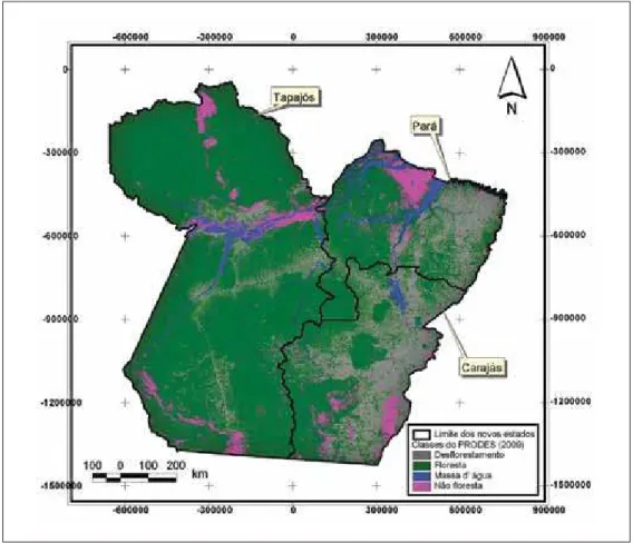
Presently, 20 percent of the state of Pará is deforested. however, consid-ering the forest areas analyzed alone, this proportion increases by 22 percent,
excluding the classes covered by non-forests, e.g., the Cerrado vegetation, not
analyzed by the PRodes project, and the state area covered by rivers and lakes (Figure 1).
despite extensive deforestation and the fact that it is one of the states that contributes the most to the whole process, in the last ten years there has been a clear tendency towards a decline in deforestation both in the Legal amazon and in the state of Pará. (Figure 2).
defor
ested ar
ea (km2)
Legal amazon Pará
Years
Linear (Pará) Linear (Legalamazon)
defor
ested ar
ea (km2)
30000
25000
20000
15000
10000
5000
0
y=-2723.7x + 28255 r2 = 0.89
y=-594.8x + 8488.1 r2 = 0.83
10000
8000
6000
4000
2000
0 3 4 5 6 7 8 09 10
Figure 2 – significant reduction of deforested areas between the years 2003 and 2010 in the Legal amazon and in the state of Pará
this came as a result of effective control and surveillance policies by both the federal and state governments, such as the establishment of the forest dis-trict in the region along the Cuiabá-santarém (BR 163) and Pa 275 highways, which intended to link the town of são Félix do Xingú to BR 163 and establish a mosaic of integral protection and sustainable use conservation units.
Protected areas in the State of Pará
there are presently 118 protected areas under federal, state and local ju-risdictions in the state of Pará, totaling 56 percent of the entire state area. of these, 16 are formed by groups of integral protection conservation units (10.1 percent of the total areas) and 50 by the group of sustainable use units (22.1 percent). there are 52 indigenous reserves and a military zone, accounting for 22. 8 percent and 1.7 percent of the state area respectively (Figure 3).
several studies have shown the effectiveness of conservation units, indig-enous reserves and other protected areas in preventing deforestation in the de-forestation arc in the Brazilian amazon.
nepstad et al. (2001) have demonstrated the inhibiting effect of Indig-enous Reserves and Integral Protection Conservation units in curbing the de-structive process in the deforestation arc in the Brazilian amazon.
protected areas, and this difference varies from 10 to 20 times between states. the largest difference is found in the state of Pará.
Special areas and jurisdiction
Integral Protection – Federal sustainable use – Federal military area – Federal Indigenous Land - Federal
Figure 3 – Federal and state Conservation units, Indigenous Reserves and military Zone in the state of Pará. the boundaries shown relate to the proposed territorial division of the state of Pará.
Ferreira et al. (2010) have demonstrated that deforestation was lower in-side than outin-side conservation units and indigenous reserves, in relation to the distance from roads in a stretch of BR 163 highway (Cuiabá-santarém) in the state of Pará, therefore evincing the clear effect of these protected areas in curb-ing deforestation.
Deforestation in the States proposed in the division of the State of Pará
three new states will be considered in this analysis as regards the intended division of the state of Pará into the states of novo Pará, tapajós and Carajás.
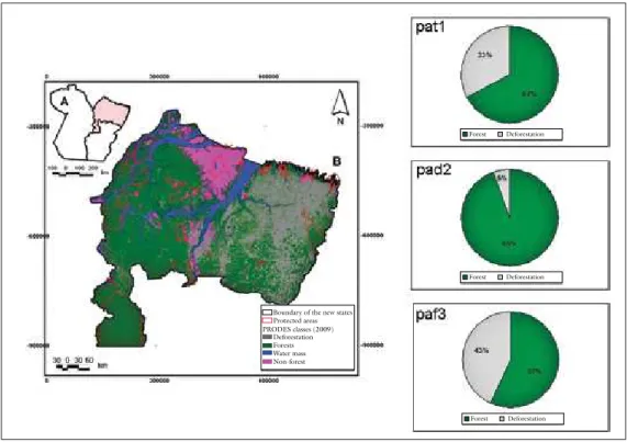
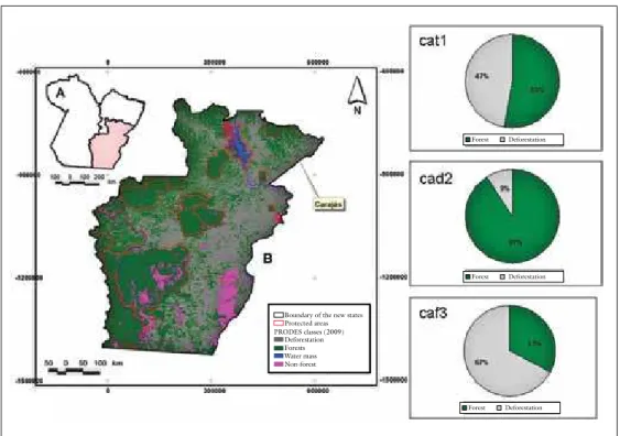
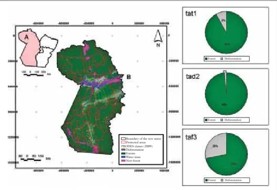
under the new configuration, the states of novo Pará and Carajás have a proportion of 33 percent and 47 percent of deforested areas respectively (Figures 4 and 5), which is significantly higher when compared to the state of tapajós - 8 percent (Figure 6).
Belém) and the occupation process along federal highways Belém-Brasília and BR 230 (the transamazônica highway) and state highway Pa 150 in the terri-tory of Carajás.
the most significant changes in deforestation patterns are perceived when deforestation in the three states proposed is analyzed, excluding deforestation inside and outside the protected areas.
Boundary of the new states Protected areas Deforestation Forests Water mass Non-forest PRODES classes (2009)
Forest Deforestation
Forest Deforestation
Forest Deforestation
Figure 4 – Classes of remaining vegetation cover in the state of Pará, showing on the right-hand side the proportion of forest and total deforestation (pat1) inside (pad2) and outside (paf3) protected areas. the boundaries shown relate to the proposed division of the state of Pará.
In the state of novo Pará, deforestation is only 5 percent inside and 45 percent outside protected areas, i.e., 8.6-fold increase. the same results are seen in the state of Carajás, where the variation between deforestation inside and outside protected areas is 9 percent and 67 percent respectively (Figure 5). In the state of tapajós, inside and outside protected areas the numbers are 2 per-cent and 28 perper-cent respectively (Figure 6).
the increase in deforestation outside protected areas shows clearly the importance of the current mosaic of conservation units and indigenous lands in curbing deforestation in the state of Pará.
Con-servation units and Indigenous Reserves, while this proportion will be reduced to 32 percent and 36 percent in the territories of Pará and Carajás respectively (table 1).
Boundary of the new states Protected areas Deforestation Forests Water mass Non-forest PRODES classes (2009)
Forest Deforestation
Forest Deforestation
Forest Deforestation
Figure 5 – Classes of vegetation cover in the state of Pará, showing on the right-hand side the proportion of forest and total deforestation (cat1) inside (cad2) and outside (caf3) protected areas. the boundaries shown relate to the proposed division of the state of Pará.
In the state of tapajós, this new spatial configuration of protected areas is worrying, since 74 percent of the new state’s territory would be officially protected, which may lead to a review of the limits of the present conservation units, in special those under state jurisdiction, which total 13.7 million hectares (11.9 percent of the total area of the proposed territory). (Figure 3).
this could occur, since with the creation of the new states the ecological- economic Zoning of the state of Pará (Zee-Pa) would no longer exist. In the Zee-Pa proposal, 65 percent of the state area is earmarked for the preservation and conservation of natural resources, the so-called preservation zones, and 35 percent for the expansion and consolidation of productive activities, known as consolidations zones (Figure 7).
units under state jurisdiction, thus increasing the pressure for occupation in previously protected areas.
Boundary of the new states Protected areas Deforestation Forests Water mass Non-forest PRODES classes (2009)
Forest Deforestation
Forest Deforestation
Forest Deforestation
Figure 6 – Classes of vegetation cover in the state of tapajós, showing on the right-hand side the proportion of forest and total deforestation (tat1), inside (tad2) and outside (taf3) protected areas. the boundaries shown relate to the proposed division of the state of Pará.
In this scenario, the entire Calha norte region in the state of Pará would be within the limits of the state of tapajós (Figure 8). In this particular region there are presently four conservation units under federal jurisdiction, six under state jurisdiction and five indigenous reserves, totaling some 21.7 million hect-ares of protected areas (table 2).
one of the concerns associated with the proposed creation of the state of tapajós is to determine the fate of the six conservation units under state Juris-diction, which total about 12.7 million hectares, or 58.5% of the total protected areas in the Calha norte region (Figure 8, table 2).
table 1 – total area and proportion of the area occupied by conservation units, in-digenous lands and a military area among the states proposed in the divi-sion of the state of Pará
Management classes
States proposed
No. of protected
areas Total area(ha) % Area
Integral Protection Carajás 4 612,065 2.1
Indigenous Reserves Carajás 14 7,193,481 25.3
Sustainable Use Carajás 6 2,315,492 8.1
TOTAL 24 10,121,038 35.6
Integral Protection Pará 1 5,719 0.0
Indigenous Reserves Pará 13 1,737,033 7.1
Sustainable Use Pará 22 5,981,840 24.5
TOTAL 36 7,724,593 31.7
Military Are Tapajós 1 2,157,153 3.0
Integral Protection Tapajós 11 12,019,300 16.7
Indigenous Reserves Tapajós 25 19,595,555 27.2
Sustainable Use Tapajós 21 19,291,808 26.8
TOTAL 58 53,063,816 73.8
Forest Deforestation
Forest Deforestation
Forest Deforestation
environmentally sensitive Consolidation Water mass Indigenous Lands Conservation units military area
Zones of Use of ZEE-PA
table 2 – name, management classes, category, jurisdiction and total area of conser-vation units at federal and state level and Indigenous lands in the Calha norte region, state of Pará that will be included in the proposal for the creation of the state of tapajós.
No. Name Management class Category Jurisdiction Total Area (ha)
1 ESEC Grão-Pará Integral protection ESEC State 4,199,120
2 PE Monte Alegre Integral protection PARE State 5,933
3 REBIO Maicuru Integral protection REBIO State 1,149,209
4 FLOTA Faro Sustainable Use FLOTA State 626,400
5 FLOTA Parú Integral protection FLOTA State 3,604,336
6 FLOTA Trombetas Integral protection FLOTA State 3,136,821
TOTAL 12,721,820
1 ESEC Jari Integral protection ESEC Federal 163,834
2 REBIO – Trombetas
River Integral protection REBIO Federal 409,185
3 TI Nhamunda-Mapuera Indigenous Land TI Federal 818,970
4 TI Tumucumaque
Indigenous Park Indigenous Land TI Federal 2,989,860
5 TI Paru d´Este River Indigenous Land TI Federal 1,194,557
6 TI Trombetas-Mapuera Indigenous Land TI Federal 2,139,713
7 TI Zo´é Indigenous Land TI Federal 668,798
8 FLONA de Mulata Sustainable Use FLONA Federal 215,483
9 FLONA de
Saracá-Taquera Sustainable Use FLONA Federal 441,279
TOTAL 9,041,679
eseC = ecological station; FLota = state Forest; FLona = national Forest; PaRe =state Park; ReBIo = Biological Reserve; tI = Indigenous Land
studies conducted by researchers from the emilio Goeldi museum in the state of Pará in the two conservation units for the management plan thereof, identified several endemic species in the areas, thus indicating their great biotic importance.
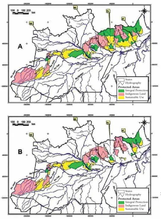
the Calha norte region is extremely important to the conservation of the amazonian biota, since it is part of a corridor of protected areas stretching from the state of amapá to the borders of the states of amazonas and acre (Figure 9).
this Corridor is formed by 52 protected areas totaling more than 56 mil-lion hectares, of which 14 are protected areas in the state of Pará, with a total of 24 million hectares or 42.4 percent of the overall corridor area (Figure 9).
Protected areas deforestation (2009) ZONES OF ZEE-PA USE
Consolidation I Consolidation II Consolidation III Water mass Indigenous Land Conservation unit
Figure 8 – space distribution of the conservation units at federal and state level and indigenous reserves in the Calha norte region, state of Pará, which will be included in the proposed creation of the new state of tapajós, in rela-tion to indicatives of use of the ecological-economic zoning of the current state of Pará.
hüttl et al. (2001) and Fearnside (2005) report that deforestation is the type of change in land use which, in the long term, has the most serious effects on climate conditions due to large greenhouse gas emissions.
It is believed that the consequences of these changes are not limited mere-ly to the amazon, as they also affect both adjacent and distant regions (Correia
et al., 2006).
nobre (2001) reports that a decrease in rainfall in the amazon followed by periods of drought may increase considerably the forest’s susceptibility to fire, leading to the extinction of species that are less tolerable to drought, and therefore altering the structure of ecosystems.
Idigenous peoples
Bhutan
Protected areas deforestation (2009) ZONES OF ZEE-PA USE
Consolidation I Consolidation II Consolidation III Water mass Indigenous Land Conservation unit
States Hydrography
Integral Protection Indigenous Land Sustainable Use Protected Areas
States Hydrography
Integral Protection Indigenous Land Sustainable Use Protected Areas
Figure 9 – Corridor of protected areas between the states of amapá, amazonas, Pará and Roraima (a), whose connectivity will be disrupted should the con-servation units under state jurisdiction be eliminated under the proposed creation of the state of tapajós.
that involve a detailed assessment on the environmental, social and economic impacts resulting from the separation of the original state. one of the most seri-ous consequences of ignoring this caveat will be the creation of a legal vacuum that will be used to increase pressure on the natural resources of the amazon.
References
aaRon, G. B. et al. effectiveness of parks in protecting tropical biodiversity. science, v.291, p.125-28, 2001.
aYRes, J. m. et al. Abordagens inovadoras para conservação da biodiversidade do Bra-sil: os corredores ecológicos das florestas neotropicais do Brasil. Brasília: ministry of environment, 1997.
CoRReIa, F. W. et al. o impacto das modificações da cobertura vegetal no balanço de água na amazônia: um estudo com modelo de circulação geral da atmosfera (mCGa).
Brazilian journal of meteorology, v.21, n.3, p.1-5, 2006.
esRI – envIRonmentaL sYstems ReseaRCh InstItute. arc GIs. the Geographic Information system for everyone. 2006.
FeaRnsIde, P. m. desmatamento na amazônia brasileira: história, índices e consequ-ências. Megadiversidade, v.1, n.1, p.113-22, 2005.
FeRReIRa, L.v. et al. o desmatamento na amazônia e a importância das áreas pro-tegidas. Estudos avançados, v.19, n.53, p.1-10, 2005.
FeRReIRa, L. v. et al. Biodiversidade In: Zoneamento ecológico-econômico da Zona Leste e Calha norte do estado do Pará: diagnóstico do Meio Físico-Biótico. management Center of the Rural pará Program, 2010. v.2, p.25-102.
FunaI (natIonaL IndIGenous FoundatIon). Indigenous lands file in shape file format (compacted). available at: <http://www.funai.gov.br/ultimas/ in-formativos/daf/cgdp/2008/arquivos/shapes_atuais.rar>. access on: 11 oct. 2011. hÜtL, R. F. et al. the Role of Land use for climate Change. In: LoZan, J. L.; GRaBL, h.; huPFeR. P. (ed.) Climate of the 21st century: changes and risks. hamburg: Wissenschaftliche auswertungen, 2001. p.278-82.
IBama – BRaZILIan InstItute FoR the envIRonment and ReneWa-BLe natuRaL ResouRCes. 2011. Limite das unidades de Conservação e terras Indígenas da amazônia Legal. available at: <http://www.ibama.gov.br>.
InPe – natIonaLInstItute FoR sPaCe ReseaRCh. 2011. Monitoramen-to da Floresta Amazônica Brasileira por satélite ProjeMonitoramen-to Prodes. available at:
<http://www.dpi.inpe.br/prodesdigital>.
BRaZILIan InstItute oF GeoGRaPhY and statIstICs (IBGe). 2005. Limite dos municípios brasileiros (www.ibge.gov.br/home/download/geociencias. shtm).
LauRanCe, W. F. et al. the Future of the Brazilian amazon. science, v.291, p.438-39, 2001.
noBRe, C. a. amazônia: fonte ou sumidouro de carbono? In: BRasIL – ministry of environment. Causas e dinâmica do desmatamento na Amazônia. Brasília: ministry of environment, 2001. p.197-224.
PeRes, C. Por que precisamos de megarreservas na amazônia. Megadiversidade, v.1, n.1, p.174-80, 2005.
abstraCt – the state of Pará has a rich diversity of ecosystems. however, it is one of the
states that contribute the most to amazon deforestation. Currently, 22% of the state is deforested. a new policy of occupation is being studied for the amazon, based on the creation of new states. the creation of new states can increase deforestation in the amazon, especially in regions where the agricultural frontier and mineral activities are intense, such as the state of Pará. this study compares the changes in the representa-tiveness of protected areas and deforestation, considering the proposed division of the state of Pará in three new states. the creation of new states can lead to a reduction or elimination of the protected areas, resulting in the increase of deforestation. another serious consequence of the creation of new states will be the extinction of the ecologi-cal-economic Zoning of Pará, an important instrument of public policy. the creation of new states must be preceded by studies involving the evaluation of environmental, social and economic variables. one of the most serious consequences if this is not taken into consideration will be the creation of a legal vacuum that will be used to increase pressure on natural resources in the amazon.
keywords: amazonian, deforestation, Protected areas.
Leandro V. Ferreira is a member of the Botany coordinating unit at the emilio Goeldi museum in the state of Pará. @ – [email protected]
Jorge L. G. Pereira is a member of the Research and Graduate program coordinating unit at the emilio Goeldi museum in the state of Pará. @ – [email protected]
Denise A. Cunha, Darley C. L. Matos and Priscilla Sanjuan are PCI graduate fellows of the Botany coordinating unit at the emilio Goeldi museum in the state of Pará. @ – [email protected] / [email protected] / [email protected] this article would not have been written without the brilliant criticism, ideas and sug-gestions of our friends Rafael solomon, silvio Brienza and ulissses Galatti.