1
Priscila Ikematsu
Researcher at Instituto de Pesquisas Tecnológicas (IPT) – São Paulo (SP), Brazil.
Omar Yazbek Bitar
Researcher at IPT – São Paulo (SP), Brazil.
Mariana Hortelani
Carneseca Longo
Researcher at IPT – São Paulo (SP), Brazil.
Sofia Julia Alves
Macedo Campos
Researcher at IPT – São Paulo (SP), Brazil.
André Luiz Ferreira
Technologist at Instituto Brasileiro de Geografia e Estatística (IBGE) – Rio de Janeiro (RJ), Brazil.
Correspondence address:
Priscila Ikematsu – Instituto de Pesquisas Tecnológicas (IPT) – Av. Prof. Almeida Prado, 532 – Cidade Universitária – CEP: 05508-901 – São Paulo (SP), Brazil – E-mail: priscilai@ipt.br
Received on: 09/25/2019 Accepted on: 02/07/2020
ABSTRACT
The analysis of permanent preservation areas (PPAs) is an important step to design technological and locational alternatives for the environmental assessment of enterprises, as well as to support the issuance of environmental licenses. Thus, the aim of the current study is to present the method developed for the environmental assessment of ventures that have direct or indirect effects on PPAs and on their environmental functions. Five steps were proposed for this analysis: the conceptualization of PPAs based on a literature review; technical visit to the study site; analysis of the environmental functions of PPAs; PPA mapping; and evaluation of projects and future uses to be applied to the area. The herein proposed method was effective and efficient in the presented case studies, since it allowed recommending adjustments in the project presented by the entrepreneur and technically supported the selection of the best locational alternative by taking into consideration the environmental legislation requirements.
Keywords: permanent preservation area; environmental assessment; environmental legislation.
RESUMO
A análise de áreas de preservação permanente (APPs) é uma atividade importante na concepção de alternativas tecnológicas e locacionais durante a avaliação ambiental de empreendimentos, bem como para apoiar a emissão de licenças ambientais. Nesse contexto, este trabalho objetivou apresentar o método desenvolvido para avaliação ambiental de empreendimentos com influência direta ou indireta em APP e em suas funções ambientais. Cinco etapas são propostas para essa análise: a conceituação da feição protegida na forma de APP por meio de revisão bibliográfica; visita técnica à área de estudo; análise das funções ambientais de APP presentes; representação cartográfica da APP; e avaliação dos projetos e os usos propostos na área. O método aqui proposto se mostrou válido e eficiente nos estudos de caso apresentados, pois permitiu recomendar ajustes no projeto elaborado pelo empreendedor e subsidiou tecnicamente a definição da alternativa locacional mais viável frente às exigências da legislação ambiental.
Palavras-chave: área de preservação permanente; avaliação ambiental; legislação ambiental.
OF PERMANENT PRESERVATION AREAS IN ENTERPRISE ASSESSMENT
ANÁLISE DA FUNÇÃO AMBIENTAL DAS ÁREAS DE PRESERVAÇÃO PERMANENTE NA AVALIAÇÃO DE EMPREENDIMENTOS
INTRODUCTION
Brazil has a complex institutional system focused on managing the environment; this system derives from a long discussion process involving different social, political and economic contexts (ALCÂNTARA, 2019). Incorporating environmental feasibility into deci-sion-making processes is a major challenge for plan-ners, as well as for public and private managers, since it means indicating the best technological and loca-tional alternatives for a given work or activity by taking into consideration environmental impacts associated with environment’s carrying capacity (SÁNCHEZ, 2006; MONTAÑO; SOUZA, 2008).
Environmental licensing and environmental impact assessment are instruments provided by the National Environmental Policy (Federal Law No. 6.938/1981). Environmental licensing is the administrative process that formalizes environmental control conditions and measures to be respected by entrepreneurs in order to enable the environmental adequacy of activities or ventures. Environmental impact assessment refers to the systematic analysis of environmental impacts de-riving from a proposed action (policy, plan, program or project) and of its alternatives. The Public Power is in charge of analyzing the feasibility of venture and activi-ty projects based on environmental resource use, since these projects can be effectively or potentially polluting or even capable of causing environmental degradation (BRASIL, 1981; SÁNCHEZ, 2006; MONTAÑO; SOUZA, 2008; AGRA FILHO et al., 2012).
Several normative measures must be taken into con-sideration at the time to issue environmental licenses. Among them, it is worth emphasizing the Forest Code — Federal Law No. 12.651/2012 (BRASIL, 2012) — , which defines the concept of Permanent Preservation Area (PPA). According to article 3 in this Law, PPAs are protected areas that have the environmental function of “preserving water resources, landscape, geological stability and biodiversity, enabling fauna and flora gene flow, protecting the soil and assuring the well-being of human populations” (BRASIL, 2012). Each PPA category defined in this law has a protection range whose specif-ic restrspecif-ictions are adopted.
The legal framework supporting PPA protection de-rived from great concern with areas acknowledged as important sources of environmental goods and
services seen as essential to human survival (BORGES
et al., 2011). During the environmental assessment of
projects, the incidence of this type of specially protect-ed area tends to influence project design, technologi-cal and locational alternatives, as well as the issuance of authorizations and licenses provided by the Brazilian legislation. It happens because anthropic interventions leading to changes in PPAs’ environmental functions are not allowed in urban or rural areas, no matter the existence, or not, of vegetation cover in these environ-ments (BORGES et al., 2011; BRASIL, 2012; IKEMATSU
et al., 2016a). Exceptional cases are explained in
arti-cle 8 of Federal Law No. 12.651/2012: interventions in APPs are allowed in cases of public utility, social inter-est and low environmental impact, provided that the inexistence of a technical and locational alternative is proved (BRASIL, 2012).
Therefore, the prohibition on removing the vegetation and on installing any form of use and occupation in APPs implies the analysis of environmental impacts caused by a given project and its alternatives; this process must comprise mapping protected features and ana-lyzing their environmental functions. However, these procedures depend on definitions set in the Forest Code, which are, in some cases, susceptible to ques-tioning due to poor clarity and concept generalization issues; besides, they are not easy to be applied under field conditions. In addition, the definition of the envi-ronmental functions and the protection range of each PPA is set by general rules, regardless of elements such as biome, aspects of the physical environment, specific features of watercourses, climate conditions specific to each microbasin, as well as local and regional contexts (IKEMATSU et al., 2016a).
The environmental functions justifying the existence of a given PPA can transcend the length defined in the ex-isting laws because they are part of a system composed of several interdependencies. According to Metzger (2010), the effectiveness of these protection areas depends on several factors such as the ecosystem ser-vice type taken into consideration and the width of the preserved vegetation. Thus, the consequences of land use in PPA must be analyzed by having in mind not only the area protected by normative instruments but also the dynamic system that sometimes can hin-der quantitative predictions. Lack of consensus about
3 the geographic interpretation of environmental legisla-tions can be a significant obstacle to the maintenance of different ecosystems and their PPAs. Therefore, the ability to properly identify areas where the Forest Code is applicable to and, consequently, areas where it is ig-nored or disrespected is a necessary precondition to assure compliance with regulations, as well as to sup-port decision-making processes and policies focused on future land use (DITT et al., 2008; METZGER, 2010).
Despite these statements, feasibility studies focused on projects based on the analysis of the environ-mental functions of PPAs remain scarce in the litera-ture. In light of the foregoing, the aim of the present study was to fill this gap by presenting the method developed to enable the environmental assessment of ventures that have direct or indirect influence on PPAs and on their environmental functions (general and specific).
ENVIRONMENTAL FUNCTION OF PERMANENT PRESERVATION AREAS
Environmental functions are associated with the role played by PPAs in maintaining ecological balance and in the natural dynamics of evolutionary processes. Thus, they play an important role in assuring the cor-rect indication of restrictions or permissions to use pro-tected areas. They also work as an important ground to assure more effective and protective ecosystem ser-vices in areas with significant environmental attributes. In addition, environmental functions are relevant in terms of internalizing environmental relevance in the set of rights and duties pertaining to intersections be-tween property rights and environmental protection (CARVALHO, 2018). Table 1 presents different PPA cate-gories and their respective delimitation criteria, based on the Brazilian Forest Code.
It is essential understanding the environmental func-tions of each PPA category in order to provide crite-ria and information that can be used to support de-cision-making processes in a given venture based on nature conservation. Thus, a brief discussion about PPA functions is herein presented, both the ones explained in article 3 of Federal Law No. 12.651/2012 (BRASIL, 2012) — herein called general environmental functions — and specific environmental functions directly linked to the evolution of environmental phenomena to be observed at the time to implement or expand a given venture (IKEMATSU et al., 2016a).
The general environmental function — “preserving water resources” — unfolds into several specific func-tions. The following specific environmental functions can be observed in areas located on the banks of rivers and watercourses: receiving and containing sediments from across the basin, mitigating sedimentation in the riverbed and the risks of silting up the watercourse; re-taining water in the microbasin; protecting the banks
and promoting stability in the edges of the water-course; assuring natural fluctuation of water levels in periods of intense rainfall and heavy water discharge; and protecting and conserving biodiversity and the as-sociated genetic heritage. These functions directly de-pend on features of the physical environment where the hydrographic basin is located in, on the incidence of vegetation, on climate and on triggering conditions that generate stress conditions or change materials’ re-sistance, such as intense rainfall or land use and occu-pation processes (MELLO, 2005).
The conditions of areas surrounding springs and of their contribution basin are strongly associated with the maintenance of the recharge area, base flow and river flow; with the survival of water sources, mainly in times of rainfall shortage; with freshwater storage with protection against losses due to evaporation; and with the preservation of water quality. It happens because these areas work as natural filter. Thus, inter-ventions made in infiltration and percolation processes tend to change groundwater flow patterns and, con-sequently, they lead to exfiltration in discharge zones with low water potential. Direct interventions such as groundwater abstraction, or indirect interventions such as recharge area waterproofing in aquifers, change the water volume in water tables and affect water flow produced by springs; consequently, they change the flow of watercourses. In addition, it is worth mention-ing the environmental function associated with the contributing hydrographic basin of each spring, since water production and spring features result from pro-cesses taking place throughout the contribution area, rather than just in the surrounding area of the spring, a fact that should also be taken into consideration in the process of environmentally assessing these features (IKEMATSU et al., 2016b).
Natural lakes and ponds, as well as artificial reser-voirs, have the environmental function of storing and retaining water; this function can be associated with
different uses (human supply, irrigation, recreation, flood control, transport and navigation, nutrient bal-ance, power generation, among others). In addition, Table 1 – Permanent preservation areas (PPA) delimitation criteria.
PPA category to
be protected PPA delimitation criterion PPA range
Peripheral range of watercourse
River width < 10 m 30 m
River width ranges from 10 to 50 m 50 m
River width ranges from 50 to 200 m 100 m
River width ranges from 200 to 600 m 200 m
River width > 600 m 500 m
Spring/ water
source Classification as spring or perennial water source around the spring50-m radius
Natural lake and pond
Rural location 100 m
Rural location with up to 20 ha 50 m
Urban location 30 m
Artificial reservoir Range defined in ventures’ environmental license.
Hillside Areas presenting slope > 45º at the highest slope line
Hilltop
Areas delimited based on contour line corresponding to 2/3 (two thirds) of the minimum hill height, always in comparison to the base, which is defined as the horizontal plane determined by the adjacent plain or water mirror, or to wavy reliefs, based on the height of the saddle point closest to
the elevation in the hills (geomorphological features with minimum height 100 m and mean slope greater than 25º).
2/3 (two thirds) of the minimum hill height, always
in comparison to
the base
Restinga
Featuring the sandy deposit parallel to the coastline, which has overall elongated shape and is generated by sedimentation processes. This environment hosts different communities presenting marine influence, mosaic-shaped vegetal cover, as well as herbaceous, shrubby and arboreal
(the most internalized one) strata depending on the successional stage; being dune fixer or mangrove stabilizer.
The entire
restinga length
Mangrove
Featuring the coastal ecosystem observed in lowlands susceptible to the action of tides. This ecosystem is formed by recent mud or sand flats, which are mainly associated with the natural vegetation known as mangrove. This vegetation is susceptible to fluvial marine influence, it is typical of muddy soils in estuarine regions and presents discontinuous
distribution along the Brazilian coast.
The entire mangrove length Plateau or
mountain range Strip in horizontal projections measured from the edge of the plateaus and mountain range up to the rupture line of the relief. Range of at least 100 m
Altitude Altitude above 1,800 m, regardless of the vegetation. Range greater than 1,800 m
Vereda Marginal strip in horizontal projection from the permanently swampy and soaked space. Range of at least 50 m
5 waterbodies present relevant scenic beauty and host several fauna and flora species. One of the main attrac-tions for tourists looking for fun and relaxation lies on water reserves, whether they are natural or artificial, since these places enable activities focused on promot-ing health and leisure (sport and recreation), scientific research, education (knowledge about the environ-ment and nature), visual appreciation of its intrinsic beauty, as well as artistic inspiration (FERREIRA; LOPES; ARAÚJO, 2012).
Hillside PPAs stand out for their geological stabili-ty function, since these areas are featured by high declivity (equal to, or greater than, 45º) where the weathering mantle, which is not very resistant, pres-ents several planes of possible ruptures (landslide). The steep slope influences the intensity of action by natural erosive agents; consequently, it influences the intensity of surface geodynamic processes of slope re-treat (CARVALHO et al., 2001). It is worth mentioning the special soil protection role played by vegetation in controlling rainfall-associated erosion in steep decliv-ity areas. Water interception by plant leaves, physical water containment by the root system, sediment filtra-tion, decrease in runoff speed, as well as maintenance of soil porosity and permeability (ARAÚJO; ALMEIDA; GUERRA, 2007), are examples of specific environmen-tal functions associated with hillside PPAs.
Hilltops have the important function of maintaining and regulating the hydrological cycle within hydrographic basins as a whole; they can influence processes such as water infiltration, percolation and runoff. Increased vertical infiltration at hilltops decreases water runoff downstream slopes and increases the geological stabil-ity and recharge of aquifers giving rise to perennial or intermittent springs (IPT, 2015).
Restingas’ formation process is originally associated
with accumulation and deposition of sandy sediments transported by sea water in coastal environments, as well as with their positioning, since they work as bar-riers to the erosive action of waves; however, their environmental function tends to change over time. It gradually changes from the initial sediment reten-tion phases to favorable condireten-tions to consolidate deposits. Later, these deposits tend to stabilize and incorporate themselves into the coastal landscape due to the establishment of plant and fauna species. Deposits experiencing ecological wholeness tend to
make accumulated sediments unavailable by retaining them in their structure and preventing their remov-al by current and predominantly naturremov-al processes. The eventual suppression of the vegetation covering sandy deposits affects the habitat of different species and tends to expose sediments to the erosive action of rainwater and winds, as well as to the impact of waves in open sea or even in lagoons and wide bars, which removes these materials and transport them to other areas. Therefore, it can lead to instability in ero-sion and sedimentation dynamics, and to accelerated loss of material in one stretch to be accumulated in another location, which can even affect human settle-ments (IPT, 2008).
Mangroves have purifying action, i.e., they work as bi-ological filters. Aerobic and anaerobic bacteria inter-act with organic matter and mud in order to fixate and inert contaminating particles (ALVES, 2001). The spa-tial effect of mangrove’s vegetation cover along the coastal zone allows immobilizing heavy metals in plants and in the soil before they reach nearby aquat-ic ecosystems; thus, this vegetation cover works as a biogeochemical barrier (OLIVEIRA, 2009). Trunks and roots, including pneumatophores, can influence wa-ter circulation and lead to the deposition and accu-mulation of sediments and particulate organic matter (LOVELOCK; ELLISON, 2007 apud LIMA; TOGNELLA, 2012). Typical mangrove trees stabilize sediments be-tween their roots and trunks, as well as work as wind barriers to mitigate the effects of storms in coastal areas; besides, they slow down the energy of wave and tidal oscillations capable of resuspending sed-iments in shallow coastal areas. Thus, they tend to improve the quality of estuarine and coastal waters, since they assure nutrient supply and immobilization in the soil and, at the same time, protect the coastline (SCHAEFFER-NOVELLI et al., 2012).
Mangrove structure also acts as a biostabilization unit that helps better conserving the coastal landscape, as protection against flooding by attenuating its energy and the advance of tides, as well as sediment deposit in fluvial marine plains (CAVALCANTI, 2004). Due to the great variety of ecological niches, which results in diver-sified fauna, and given the incidence of endemic spe-cies (visitors or migratory) in this environment, man-groves act as important biological diversity maintainers (ALVES, 2001). In addition, mangroves are essential
to the development of socioeconomic activities asso-ciated with artisanal fishing and with the sustainable exploitation of coastal renewable resources, which at-tract human populations that settle in the surrounding areas. Riverside communities are highly dependent on resources provided by mangroves, whose survival de-pends on the exploitation of the benthic macrofauna as source of food and income, wood extraction, medi-cines, alcohol, oils and tannins, ecological tourism, nav-igation and environmental education in this ecosystem (LAMPARELLI, 1998; SEMACE, 2006).
Plateaus and mountain ranges do little to promote sur-face water flow and allow greater water movement to-wards the subsurface in order to supply water tables and springs (BORGES, 2008; CPRM, 2013). According to Resende et al. (1995), instability in the edges of pla-teaus and mountain ranges is associated with low soil pedogenesis and erosion ratio. Thus, gravitation-al movements of mass, rock and fgravitation-alling blocks are the main processes linked to the natural dynamics of pla-teaus and mountain ranges. In addition, the edges, escarpments, foothill and plateau of flat-topped re-liefs covered with vegetation form ecological corridors for fauna and flora, assure the continuous circulation of gene flow from the top to the base and along the plateau, promote ecological connectivity in the land-scape and, consequently, help preserving biodiversity. Finally, it is worth mentioning the heterogeneity of habitats that the environment in the edges of plateaus and mountain ranges can provide to regional fauna
and flora. This environment is particularly important for some plant species that preferentially colonize these rocky habitats, since they are capable to adapt to water shortage and to poorly developed substrates (POREMBSKI et al., 1998). In addition, some fauna spe-cies prefer this environment at the time to build their nests and take shelter, like swallows and birds of prey.
Veredas are swampy or wet places presenting
hydro-morphic soils and typical vegetation (BRASIL, 2012); they are important to local populations due to peren-nial water availability in regions where this resource is significantly scarce, such as central Brazil. They also play a fundamental role in biodiversity, since they host several Cerrado flora and fauna species; they are true ecological corridors capable of interconnecting Cerrado fragments in order to enable matter and gene flow (GUIMARÃES, 2012).
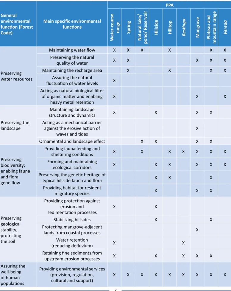
It is essential maintaining the environmental function of PPAs in order to assure balance in processes as-sociated with them and to prevent the incidence of events capable of affecting the well-being of human populations and ecosystems. Anthropic interventions can lead to changes in environmental processes and, consequently, in the herein addressed environmental functions. Thus, it is important analyzing these inter-ventions at the time to set guidelines to implement projects and to map the area to be protected. Table 2 presents environmental functions (general and specif-ic) that can be taken into consideration in the environ-mental assessment of projects that can affect PPAs.
MATERIALS AND METHODS
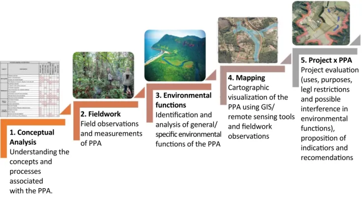
The complexity of the topic at hand, in association with its interdisciplinary nature, indicates the need of combining different methodological approaches capa-ble of completing each other to enacapa-ble more robust analyses and incisive inferences to help better under-standing the cases to be analyzed. Thus, the present study has followed an exploratory methodological ap-proach based on bibliographic research; a quantitative approach based on mappings and on the use of indica-tors; and a descriptive approach based on case studies (MINAYO, 2000; CRESWELL, 2010). Figure 1 depicts the steps proposed for the evaluation of projects with in-fluence on PPAs and on their environmental functions (general and specific).
The first step of the proposed method lies on the con-ceptual analysis of the protected feature in the form of PPA, not only within the legal scope, but also according to the available technical-scientific literature. This step is important, since PPA delimitation resulting from di-rect legislation application is not an easily executable task due to a whole variety of possible interpretations about its meaning, which can lead to different and con-tradictory results. It is important properly understand-ing the concepts involved in PPA delimitation to avoid mistakes at the time to apply guidelines deriving from legal documents. Thus, it is necessary searching for reference studies on the WEB and in libraries, based on previously defined keywords, as well as reading
7
Table 2 – General environmental functions and examples of specific environmental functions of permanent preservation areas (PPA).
General environmental function (Forest Code)
Main specific environmental functions PPA W at er -c our se rang e Spring Na tur al lak e/ pond/ R eser voir Hillside Hillt op Res tinga Mangr ov e Pla teau and moun tain r ang e Vereda Preserving water resources
Maintaining water flow X X X X X X
Preserving the natural
quality of water X X X X X
Maintaining the recharge area X X X X
Assuring the natural
fluctuation of water levels X Acting as natural biological filter
of organic matter and enabling
heavy metal retention X X X
Preserving the landscape
Maintaining landscape
structure and dynamics X X X X
Acting as a mechanical barrier against the erosive action of
waves and tides X
Ornamental and landscape effect X X X X
Preserving biodiversity; enabling fauna and flora gene flow
Providing fauna feeding and
sheltering conditions X X X X X X X
Forming and maintaining
ecological corridors X X X X X X
Preserving the genetic heritage of
typical hillside fauna and flora X X X
Providing habitat for resident
migratory species X X X Preserving geological stability; protecting the soil
Providing protection against erosion and
sedimentation processes X X
Stabilizing hillsides X X
Protecting mangrove-adjacent
lands from coastal processes X
Water retention
(reducing defluvium) X X
Retaining fine sediments from
upstream erosion processes X X X X X
Assuring the well-being of human populations
Providing environmental services (provision, regulation,
technical documents made available by companies, such as environmental impact studies, environmental control plans, specific projects already in place, among others. It is done to identify multiple components, pro-cesses and interactions that can be established within the scope of ecosystems, which are likely influenced by the expansion of activities implemented by companies in PPAs. Furthermore, the regional context of PPA is also essential to better understand the physical, biotic and anthropic situation of the venture.
The second step comprises the technical visit to the study site, which must be carried out to enable field recognition of areas to be evaluated as to the presence of environmental functions; this step must cover initial data collection, mapping validation and photographic record procedures.
The third step includes the analysis of the environmen-tal functions of the PPA identified in each case, since the application of Law postulates depends on the clari-ty about the ecological role played by them, which will be safeguarded by regulatory actions or changed by the intervention in the PPA. The Forest Code only indicates
general environmental functions, which are explained in the definition of PPA set in its article 3. Specific envi-ronmental functions can be defined given the peculiar-ity of each case, since such functions are susceptible to periodic measurement and more directly linked to the evolutionary analysis of the environmental phenome-na to be observed. The assessment of environmental functions (general and specific), based on the literature about the topic and on the environmental legislation, takes into consideration the interaction among phys-ical environment (geology, geomorphology, geotech-nics, hydrology, hydrogeology and surface dynamics processes), biotic (fauna and flora) and anthropic (land use and legislation) aspects.
The fourth step encompasses the cartographic rep-resentation of the PPA, which is carried out based on mathematical functions available in the Geographic Information System (GIS) software, on remote sensing and on field work. This procedure is essential to spatial-ly indicate the location of conflicts between intended uses and incident rules. It is important associating GIS techniques and on-site surveys, since PPA demarcation,
1. Conceptual Analysis Understanding the concepts and processes associated with the PPA.
2. Fieldwork Field observa�ons and measurements of PPA 3. Environmental func�ons Iden�fica�on and analysis of general/ specific environmental func�ons of the PPA
4. Mapping Cartographic visualiza�on of the PPA using GIS/ remote sensing tools and fieldwork observa�ons 5. Project x PPA Project evalua�on (uses, purposes, legl restric�ons and possible interference in environmental func�ons), proposi�on of indica�ors and recomenda�ons
9 strictly in the field, is conditioned by a series of factors such as access to the area of interest, time of year (dry or rainy), specific instruments (GPS, altimeter, clinom-eter, topographic maps), study execution time, among others. These factors can make it hard, or even impos-sible, to recognize the existence, or not, of a given PPA within the desired period, mainly when the study in-volves large-scale projects.
Finally, the fifth and last step lies on the evaluation of the proposed projects and uses of the area based
on legal restrictions and on likely interference in its environmental functions (general and specific). In ad-dition, the influence of anthropic actions on process-es associated with the natural dynamics of the envi-ronment is addressed, recommendations are made by taking into consideration the compliance with the legislation, the importance of the identified environ-mental functions and the possible direct and indirect changes that may take place in the region affected by the venture.
RESULTS AND DISCUSSION
Two cases will be used to exemplify the application of the methodology in the evaluation of projects capable of interfering in PPAs and in their environmental func-tions. Aspects linked to the conceptualization, environ-mental functions, cartographic representation and en-vironmental assessment process of the venture will be addressed in each case.
The first case analyzed the expansion of activities per-formed by a company specialized in building agricultur-al machinery, whose land was in a region presenting
flat-topped relief, i.e., with possible influence on PPA in the edges of plateaus and mountain ranges. It was selected to exemplify how the proposed method can contribute to the analysis of project insertion in PPA. The second case refers to studies carried out in order to expand the waste disposal area in a primary aluminum and alumina production company, which may have ef-fects on the environmental functions of a spring PPA. The method of choice in this study was applied to help selecting the best location alternative for the project.
Permanent preservation areas in the edges of plateaus or mountain ranges
The case study focused on evaluating the project’s influence on PPAs in plateaus or mountain ranges consisted of an area designed to expand the activi-ties of an agricultural machinery company in Central-West São Paulo State. The land to be occupied by the new facilities corresponds to a section of the watershed divider of Aguapeí and Peixe rivers; based on the geological-geomorphological perspective, it is regionally located in Paraná Sedimentary Basin and in the morphosculpture of Planalto Ocidental Paulista (São Paulo Western Plateau), more precise-ly in Marília Residual Plateau (Planalto Residual de Marília), which is featured by the presence of a typ-ical flat-topped relief. Federal Law No. 12.651/2012 (BRASIL, 2012) establishes that PPAs in the edges of plateaus or mountain ranges correspond to a range never smaller than 100 m in horizontal projections up to the rupture line of the relief.
The application of Step 1 of the proposed methodol-ogy has indicated that terms such as “plateaus” and “mountain ranges” are similar to terms such as “mesa”,
“high plain”, “ridges” and “chapadões”. All these terms are used to represent different geoforms of flat-topped relief, although they present some divergences in delimitation criteria. Definitions of these terms, which were presented by different authors (SOUZA, 1939; AB’SÁBER, 1964; IPT, 1981; GUERRA, 1993; FLORENZANO, 2008; IBGE, 2009; DANTAS, 2010), as well as in normative documents (BRASIL, 2002; 2012), have shown that:
• the concept of plateau is overall associated with ta-blelands and high plateaus;
• plateau tops present smooth dissection and low slope;
• plateaus are described as a hillock relief;
• they are delimited by high and straight slopes in es-carpments or steps;
• they present sedimentary rocks and sandy soils;
• plateaus are located at lower altitudes when com-pared to mountain ranges.
On the other hand, based on the literature (HARTT, 1870; SOUZA, 1939; AB’SÁBER, 1956; GUERRA, 1993; IPT, 1981; CASSETI, [2005]; FLORENZANO, 2008; IBGE, 2009; DANTAS, 2010; BRASIL, 2002; 2012; MARTINS; SALGADO, 2016), the term “mountain range” is over-all associated with tablelands and high plateaus, pres-ents sedimentary rocks and horizontal structure, it is abruptly individualized by its high and straight slopes in escarpments or steps, and has low slope at the top. Martins and Salgado (2016, p. 174) have also empha-sized that “the name given to this relief results from the process, rather than from its shape”, i.e., it is in-trinsically linked to the physical and chemical process-es marking its evolution. Thus, according to the afore-mentioned authors, differentiating flat-topped reliefs is a hard task, mainly in the case of plateaus, which present similar evolution linked to the lateral retrac-tion of the slopes.
Features described in the definition of flat-topped re-liefs were observed in the study site during the field visit (Step 2). These reliefs presented flat and extensive tops, altitude of approximately 200 m in comparison to the surrounding hills and integrated the surface of Marília Residual Plateau. This configuration was visible on the slopes located to the West, South and Southeast of the venture, where erosive scarps imposed them-selves against the broad hills of the lower surface and left typical colluvial deposits in their foothills. Aerial images collected by an unmanned aerial vehicle (UAV) model Phantom 3, equipped with a 4k camera, helped analyzing specific aspects and allowed having region-al view of the area to be mapped. The hillsides of the rugged areas located to the Southeast and West of the venture plots presented accelerated dynamics in the lateral retraction of the slopes and favored the notch-ing of drainages in areas located on the opposite side, where linear erosive processes prevail. Such retraction left scars from a recent sliding event on these slopes. Despite being less slopped, since they rarely reach 45° inclination, these hillsides are featured as a sector with high potential to present further escarpments resulting from headward erosion in that section.
According to Step 3, the environmental functions of these geoforms were evaluated in the regional context of the study site, since they are intrinsical-ly linked to its structural configuration. Plateaus and mountain ranges are arranged on horizontal structure
lithologies, mainly on the ones of sedimentary origin, which resemble tablelands or elevated surfaces dis-sected in a hillock relief. Overall, they are composed of flattened and elongated tops of low slope and steep at the edges (straight and sloping sides). They occupy extensive surfaces with medium and low topographic altitude, and they are featured by the presence of san-dy, well-drained soils. Thus, their environmental func-tions lie on maintaining water flow, preserving the nat-ural quality of water, maintaining the recharge area, well as the structure and dynamics of the landscape, stabilizing slopes, ornamental and landscape effects, providing fauna feeding and sheltering conditions, forming and maintaining ecological corridors, among others, as shown in Table 2.
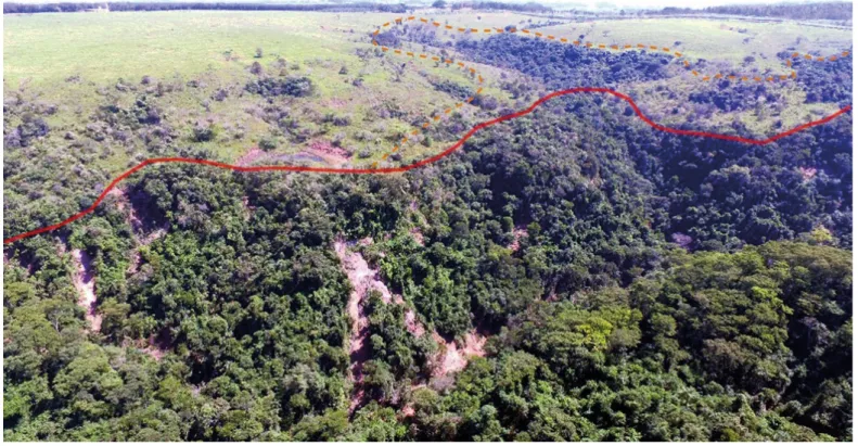
Based on Step 4, plateaus had their extension mapped based on dictates of the Forest Code, on the concept outlined in Step 1 and on information collected in the field visit in Step 2. The cartographic procedure carried out to enable PPA delimitation consisted of the spatial-ization of a 100-m section from the previously defined rupture line — it was performed with the aid of the buf-fer tool available in ArcGIS 10.5. The tracing of the rup-ture line (polyline vector file) characterizing the fearup-ture to be protected and determining the lower limit of the PPA in the edges of plateaus or mountain ranges was defined based on planialtimetric survey conducted in the venture area, satellite and radar images, digital or-thophotos, topographic sheets, hydrographic network and information collected in the field. The context of the flat-topped reliefs in the study site was assessed based on pre-existing geomorphological maps, which worked as a starting point for further adjustments in the project scale.
Figure 2 shows the approximate delimitation of the rupture line (continuous, red) from where the PPA strip (100-m buffer) is drawn, which presents land use restrictions. Based on the environmental functions of plateaus and mountain ranges identified in Step 3, the erosive escarpment advancement sector (orange dashed line) was included in the final mapping due to its relevance to the planning of future intended uses in the venture area.
The analysis of the project to expand the venture in the mapped PPAs was conducted in the last step. It indi-cated that the area selected for earthworks (cut/fill) in the project presented by the company did not advance
11 within the limits of the PPA in the edges of plateaus and mountain ranges, if one takes into consideration the locally delimited rupture line. However, there were pre-existing wells in the Northwest section of the ven-ture in the area where the delimited PPA is located in; some of them were very close to the relief rupture line. Another aspect highlighted in the analysis refers to the proximity of the structures designed to temporary ac-cumulate rainwater and to regulate the outflow (deten-tion reservoirs) close to the sector with high potential to present advancement of escarpments. It was possi-ble noticing that two projected structures were outside the PPA in the edges of plateaus and mountain ranges, but they were in an area that requires attention to be given to evolutionary processes of headward erosion
advancement in that section. In addition, designed en-ergy dissipators could also have influence on the natu-ral dynamics of physical and biotic components. In view of the systematized elements, besides the delimi-tation of local rupture and correlated PPA, it was possible pointing out areas more susceptible to physical environ-ment processes due to escarpenviron-ment erosion advanceenviron-ment and to the nature of the soil and rocky substrate (sand-stone). It was recommended avoiding interventions in these regions — although they did not configure PPAs in the edges of plateaus and mountain ranges, as defined in the legislation — by taking into consideration the environ-mental fragility intrinsic to the nature of the soil and rocky substrate and the environmental functions of these areas.
Spring permanent preservation area
The analyzed venture and its influence on the spring PPA consisted of expanding a given area for bauxite waste disposal, which could be carried out in two alter-native locations. The first alteralter-native, called Scenario
1, kept the PPA preserved, but it required a larger area to store the waste. Scenario 2, on the other hand, had direct influence on the spring and on its respective PPA due to the construction of the disposal area. Scenario
Source: IPT (2016).
Figure 2 – Approximate delimitation of the rupture line (red continuous line) and of the erosive escarpment advancement sector (orange dashed line) in an image captured with UAV model Phantom 3.
0 was also taken into consideration; it represented the current situation without the project’s interference and it was used as a reference parameter for the anal-ysis of environmental functions, since virtually all the future interference area in this configuration was cov-ered with native vegetation. According to Federal Law N. 12.651/2012, the source or “the natural outcrop of the perennial water table that starts a watercourse” (article 2) must be protected at minimum range of 50 m from the water emergence point (BRASIL, 2012). The analysis carried out in the first step of the pro-posed methodology has indicated that, despite the notorious environmental importance of springs in geo-environmental research, studies about them remain scarce; they are mostly focused on making superficial physiological and hydrological descriptions. Theoretical studies specifically focused on springs are rare, a fact that leaves some gaps in the definition of their con-cept (FELIPPE; MAGALHÃES JÚNIOR, 2013) and reflects on the adopted cartographic procedures. According to the technical-scientific literature (GUERRA, 1993; CUSTÓDIO; LLAMAS, 1996; CALHEIROS et al., 2004; VALENTE; GOMES, 2005; GOMES; MELO; VALE, 2005; SANTOS, 2009; PEREIRA et al., 2011; UNESCO, 2012; BRASIL, 2002; 2012; MAGALHÃES et al., 2012; FELIPPE; MAGALHÃES JÚNIOR, 2013), the incidence of springs is overall associated with:
• groundwater outcrop, either punctual or in zones;
• watercourse origin;
• natural occurrence;
• headland regions;
• surface/groundwater integration.
The concept of spring is approached in different ways, without defined uniformity, since it involves signifi-cant environmental complexity. Carmo, Felippe and Magalhães Junior (2014) have emphasized that spring diagnosis must include the geomorphological set of spring and drainage network conformation, exfiltration type (punctual, diffuse or multiple springs), mobility of the emergence place (fixed or mobile springs) and sea-sonality (perennial, intermittent or ephemeral springs), among other parameters, due to the great heterogeneity
of springs. Other elements mentioned in the literature comprise topographic conditions, geological and hydro-geological context (PEREIRA et al., 2011; SANTOS, 2009), hygrophilous vegetation incidence areas (CARVALHO; RIOS; SANTOS, 2013) and hydromorphism in soils involv-ing the sprinvolv-ings (MAGALHÃES et al., 2012).
Field visits made in Step 2 allowed seeing that the ex-pansion project takes place on land with incidence of spring, whose area is distributed over an extensive sur-face and forms a swamp without free-water sursur-face; some water emergence points form igarapés (water-courses). It was also possible seeing relevant biodiver-sity, the presence of natural and recovered vegetation cover and watercourses, as well as that the site is an aquifer recharge area.
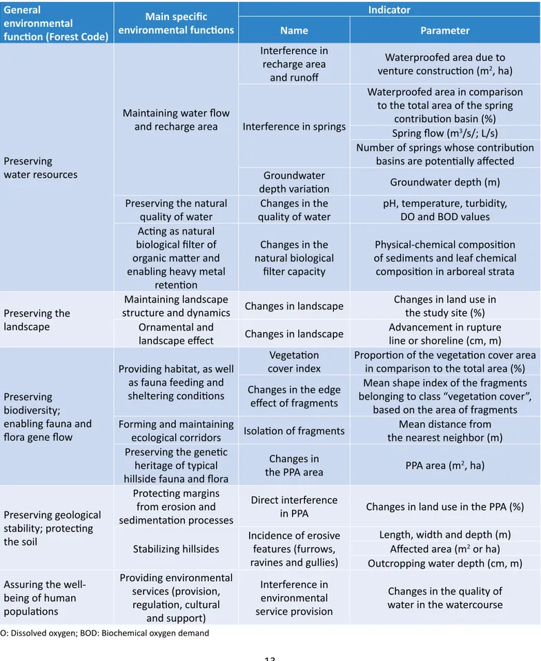
Environmental functions were analyzed in the third step of the proposed method and correlated to indicators in order to compare changes resulting from the venture in each of the two scenarios presented by the company (Scenario 1 — without interference in spring PPA; and Scenario 2 — with direct intervention in PPA). The se-lection of indicators was based on the legislation at fed-eral, state and local levels, on specific environmental functions defined in this assessment, on elements that were not addressed in the pre-existing studies made available by the company and on the likely constructive evolution of the work in the territory and in the envi-ronmental system (natural and anthropic). The concept of environmental indicator is the integrated representa-tion of a certain set of data, informarepresenta-tion and knowledge about possible changes in the performance of environ-mental functions due to the venture. It communicates, in a simple and objective way, the essential features and the meaning of this activity in the progress, or regres-sion, of the environmental condition (PNUMA, 2004). Table 3 presents the environmental functions of PPAs and the indicators in the comparative assessment of the venture’s influence on these protected areas.
The fourth step lied on mapping springs and their re-spective PPAs based on a combination of techniques, geoprocessing tools and field data. Tools available in the GIS software were used to develop the Digital Terrain Model (Topo to Raster function of the ArcGIS 10.5 software), to generate the drainage network in the study site (TerraView Hidro 4.1.0 software), to rank the drainage network (Hydroflow 0.9 software), to extract the initial points of first-order channels
13
DO: Dissolved oxygen; BOD: Biochemical oxygen demand
Table 3 – Environmental function (general and specific) of permanent preservation areas (PPA) and examples of indicators for comparative analysis of locational alternatives.
General environmental function (Forest Code)
Main specific environmental functions Indicator Name Parameter Preserving water resources
Maintaining water flow and recharge area
Interference in recharge area
and runoff
Waterproofed area due to venture construction (m2, ha)
Interference in springs
Waterproofed area in comparison to the total area of the spring
contribution basin (%) Spring flow (m3/s/; L/s)
Number of springs whose contribution basins are potentially affected Groundwater
depth variation Groundwater depth (m)
Preserving the natural
quality of water quality of waterChanges in the pH, temperature, turbidity, DO and BOD values Acting as natural
biological filter of organic matter and enabling heavy metal
retention
Changes in the natural biological
filter capacity
Physical-chemical composition of sediments and leaf chemical composition in arboreal strata Preserving the
landscape
Maintaining landscape
structure and dynamics Changes in landscape Changes in land use in the study site (%) Ornamental and
landscape effect Changes in landscape Advancement in rupture line or shoreline (cm, m)
Preserving biodiversity; enabling fauna and flora gene flow
Providing habitat, as well as fauna feeding and sheltering conditions
Vegetation
cover index Proportion of the vegetation cover area in comparison to the total area (%) Changes in the edge
effect of fragments
Mean shape index of the fragments belonging to class “vegetation cover”,
based on the area of fragments Forming and maintaining
ecological corridors Isolation of fragments the nearest neighbor (m)Mean distance from Preserving the genetic
heritage of typical hillside fauna and flora
Changes in
the PPA area PPA area (m2, ha)
Preserving geological stability; protecting the soil
Protecting margins from erosion and sedimentation processes
Direct interference
in PPA Changes in land use in the PPA (%)
Stabilizing hillsides Incidence of erosive features (furrows, ravines and gullies)
Length, width and depth (m) Affected area (m2 or ha) Outcropping water depth (cm, m) Assuring the
well-being of human populations Providing environmental services (provision, regulation, cultural and support) Interference in environmental service provision
Changes in the quality of water in the watercourse
(Feature Vertices to Points function of the ArcGIS 10.5 software), to validate data in orthogonal view (Global Mapper software) and to delimit the spring contribution basin (Hydrological Modeling function of the TerraView Hidro 4.1.0 software). In addition, the spring contribution basin was mapped, although it did not constitute a PPA, since the 50-m radius makes little contribution to water flow due to its small extension in comparison to the hydrographic basin encompassing it. Thus, the entire contribution area deserves atten-tion as to the environmental funcatten-tions it represents, notably the ones related to rainwater infiltration ca-pacity (CALHEIROS et al., 2004). In cases of intermit-tent springs, contribution basin protection tends to as-sure the temporal continuity of rainwater infiltration, percolation, storage and exfiltration processes, de-pending on the natural rhythm of the system (CARMO; FELIPPE; MAGALHÃES JUNIOR, 2014).
The last step lied on evaluating the project in the spring PPA and its mapped contribution basin. Based on the selected indicators and parameters, it was possible seeing that Scenario 1 tends to require larger vegeta-tion suppression area and larger waterproofed surface, which can lead to changes in surface water runoff and in groundwater dynamics (responsible for recharging aquifers, for maintaining springs and for assuring the continuity of downstream watercourses) with predic-tions of relatively greater magnitude. Consequently, one can expect greater changes in the flow of watercourses originated by the spring, as well as greater variation in groundwater depth, greater reduction in the self-purifi-cation capacity of waterbodies, greater interference in
biodiversity, lesser landscape connectivity and greater interference in environmental service provision, mainly the ones directly linked to the availability of environ-mental resources from forest ecosystems, such as food and wild resource provision (buriti, açaí, palmito-juçara, among others). Thus, Scenario 2 has shown to have less-er influence on the genless-eral and specific environmental functions of PPAs than Scenarios 1 and 0.
Results in the current study have technically substan-tiated the definition of the most viable location al-ternative, based on the environmental legislation. In addition, a series of recommendations and comple-mentary actions focused on collecting data and infor-mation necessary to monitor the defined indicators and parameters was listed, namely: integrated moni-toring of watercourse and spring flows that may be af-fected by the construction of the waste disposal area, as well as the integrated monitoring of the correspond-ing water levels and rainfall variations; use of collected data for studies about artificial recharge and ecological flow; diagnosis and monitoring of the composition and abundance of native forest and river system species. These actions will enable greater technical basis to help better understanding variables (biotic and abiotic, natural and anthropic) and possible interference in the investigated environmental functions. However, it is important emphasizing that, regardless of the catego-ry, PPAs are places whose fragility leads to negative im-pacts in case of anthropogenic changes in any of their physical and/or biological components; they tend to change their environmental functions in the short, mid or long-term, although sometimes in an indirect way.
CONCLUSION
The herein presented case studies highlight the impor-tance of understanding the regional context of definitions available in the literature and of specific environmental functions of PPAs in the environmental assessment of changes resulting from the implementation of projects. Results have shown that each PPA is part of a system composed of several interdependencies, where conse-quences must be analyzed not only in the range protect-ed by normative instruments but also in the dynamic and non-linear set they are inserted in. The analysis of ven-tures in PPAs, based on their environmental functions, allows understanding how these protected areas will be
directly or indirectly affected by them and it may indicate the need of expanding the area to be protected beyond the legally established one. In addition, the definition of specific indicators and parameters provides subsidies to compare changing trends due to the socio-environmen-tal of PPAs’ functions. It is possible concluding that the proposed method proved to be valid and efficient in the herein presented case studies, since it enabled rec-ommending adjustments to the project prepared by the entrepreneur and technically subsidized the definition of the most viable locational alternative based on the envi-ronmental legislation about the functions of PPAs.
15
REFERENCES
ALCÂNTARA, M. S. Áreas de preservação permanente e o direito à propriedade. Revista da Procuradoria-Geral do
Estado do Espírito Santo, Vitória, 2019.
AB’SÁBER, A. N. A terra paulista. Boletim Paulista de Geografia, São Paulo, n. 23, 1956.
AB’SÁBER, A. N. O relevo brasileiro e seus problemas. In: AZEVEDO, A. (org.). Brasil: a terra e o homem. São Paulo: Companhia Editora Nacional, 1964.
AGRA FILHO, S. S.; MARINHO, M. M. D. O.; ORRICO, S. R. M.; SANTOS, F. C. Oportunidades de aprimoramento do processo de avaliação de impacto ambiental no Estado da Bahia. Revista Brasileira de Ciências Ambientais, n. 26, p. 33-43, 2012.
ALVES, J. R. P. Manguezais: educar para proteger. Rio de Janeiro: FEMAR; SEMADS, 2001. 96 p.
ARAÚJO, G. H. de S.; ALMEIDA, J. R.; GUERRA, A. J. T. Gestão Ambiental de áreas degradadas. Rio de Janeiro: Bertrand Brasil, 2007. 320 p.
BORGES, L. A. C. Aspectos técnicos e legais que fundamentam o estabelecimento das Áreas de Preservação Permanente
(APP). Tese (Doutorado em Engenharia Florestal) – Universidade Federal de Lavras, Lavras, 2008.
BORGES, L. A. C.; REZENDE, J. L. P.; PEREIRA, A. A.; COELHO JÚNIOR, L. M.; BARROS, D. A. Áreas de preservação permanente na legislação ambiental brasileira. Ciência Rural, Santa Maria, v. 41, n. 7, p. 1202-1210, 2011. https://doi. org/10.1590/S0103-84782011000700016
BRASIL. Conselho Nacional de Meio Ambiente (CONAMA). Resolução nº 303, de 20 de março de 2002. Dispõe sobre parâmetros, definições e limites de Áreas de Preservação Permanente. Diário Oficial da União, Brasília, 2002.
BRASIL. Lei nº 6.938, de 31 de agosto de 1981. Dispõe sobre a Política Nacional do Meio Ambiente, seus fins e mecanismos de formulação e aplicação, e dá outras providências. Diário Oficial da União, Brasília, 02 ago. 1981. BRASIL. Lei nº 12.651, de 25 de maio de 2012. Dispõe sobre a proteção da vegetação nativa e dá outras providências.
Diário Oficial da União, Brasília, 28 maio 2012.
CALHEIROS, R. O.; TABAI, F. C. V.; BOSQUILIA, S. V.; CALAMARI, M. Preservação e Recuperação das Nascentes. Piracicaba: Comitê das Bacias Hidrográficas dos Rios PCJ, 2004. 40 p.
CARMO, L. G.; FELIPPE, M. F.; MAGALHÃES JUNIOR, A. P. Áreas de Preservação Permanente no entorno de nascentes: conflitos, lacunas e alternativas da legislação ambiental brasileira. Boletim Goiano de Geografia, v. 34, n. 2, p. 275-293, 2014. https://doi.org/10.5216/bgg.v34i2.31733
CARVALHO, A. P. F.; CARVALHO JR., O. A. ; LEITE, L. L.; GUIMARÃES, R. F.; MARTINS, E. S. Desenvolvimento de metodologia
em SIG para zoneamento ecológico: estudo de caso da bacia do ribeirão do gama – DF. Planaltina, DF: Embrapa
Cerrados, 2001. p. 19. (Documentos).
CARVALHO, D. W. A função ambiental da propriedade: caráter conceitual para a modulação de conflitos socioambientais.
Revista de Direito da Cidade, v. 10, n. 3, p. 1662-1691, ago. 2018. https://doi.org/10.12957/rdc.2018.3308
CARVALHO, R. B.; RIOS, M. L; SANTOS, D. B. Espacialização e caracterização do estado de conservação das nascentes da microbacia do Rio Fumaça – Município de Pindobaçu, Bahia. Enciclopédia Biosfera, Goiânia, v. 9, n. 16, p. 135-148, 2013. CASSETI, V. Geomorfologia. [2005]. Available at: <https://geografiaambiental.files.wordpress.com/2010/12/ geomorfologia.pdf>. Access on: Jan. 2019.
CAVALCANTI, A. P. B. Análise integrada das unidades paisagísticas na planície Deltaica do rio Parnaíba – Piauí/Maranhão.
Revista de Geografia da UFC, ano 3, n. 6, 2004.
CRESWELL, J. W. Projeto de pesquisa: métodos qualitativo, quantitativo e misto. Tradução: M. Lopes. 3. ed. Porto Alegre: Artmed, 2010.
CUSTÓDIO, E.; LLAMAS, M. R. Hidrologia Subterrânea. Barcelona: Ediciones Ômega S.A, 1996.
DANTAS, M. E. Biblioteca de relevo do território brasileiro. In: PEIXOTO, C. A. B. (org.). Geodiversidade do Estado de São
Paulo. São Paulo: CPRM, 2010.
DITT, E. H.; KNIGHT, J. D.; MOURATO, S.; PADUA, C. V.; MARTINS, R. R.; GHAZOUL, J. Defying legal protection of Atlantic Forest in the transforming landscape around the Atibainha reservoir, south-eastern Brazil. Landscape and Urban
Planning, v. 86, n. 3-4, p. 276-283, 2008. https://doi.org/10.1016/j.landurbplan.2008.04.001
FELIPPE, M. F.; MAGALHÃES JÚNIOR, A. P. Conflitos conceituais sobre nascentes de cursos d’água e propostas de especialistas. Revista Geografias, v. 9, n. 1, p. 70-81, 2013.
FERREIRA, R. C.; LOPES, W. G. R.; ARAÚJO, J. L. L. A água como suporte para atividades de lazer e turismo: possibilidades e limitações da barragem Piracuruca no Estado do Piauí (Brasil). Revista Ra’e Ga, v. 25, p. 134-163, 2012. http://dx.doi. org/10.5380/raega.v25i0.28007
FLORENZANO, T. G. Introdução à geomorfologia. In: FLORENZANO, T. G. (org.). Geomorfologia: conceitos e tecnologias atuais. São Paulo: Oficina de Textos, 2008.
GOMES, P. M.; MELO, C.; VALE, V. S. Avaliação dos impactos ambientais em nascentes na cidade de Uberlândia- MG: análise macroscópica. Sociedade e Natureza, Uberlândia, v. 17, n. 32, p. 103-120, jun. 2005.
GUERRA, A. T. Dicionário geológico-geomorfológico. 8. ed. Rio de Janeiro: IBGE, 1993.
GUIMARÃES, M. R. B. Possibilidades de intervenções em veredas no estado de Minas Gerais. Âmbito Jurídico, Rio Grande, XV, n. 99, 2012.
HARTT, C. F. Geology and physical geography in Brazil. Boston: Fields, Osgood & Co., 1870.
IKEMATSU, P.; BITAR, O. Y.; LONGO, M. H. C.; CAMPOS, S. J. A. M.; FERREIRA, A. L. Função ambiental das áreas de preservação permanentes no contexto do licenciamento ambiental de diferentes empreendimentos. In: CONGRESSO BRASILEIRO DE AVALIAÇÃO DE IMPACTO AMBIENTAL, 2016. Annals [...]. Ribeirão Preto, 2016a. 7 p.
IKEMATSU, P.; CORRÊA, N. F.; TAVARES, T.; FACCINI, L. G; TERRELL, D.; MONTEIRO, A. C. M. C.; LONGO, M. H. C. Aspectos técnicos para priorização de recursos em recuperação e conservação de nascentes. In: CONGRESSO BRASILEIRO DE ÁGUAS SUBTERRÂNEAS, 19., 2016. Annals [...]. Campinas, 2016b. 18 p.
INSTITUTO BRASILEIRO DE GEOGRAFIA E ESTATÍSTICA (IBGE). Manual técnico de geomorfologia. Rio de Janeiro: IBGE, 2009. INSTITUTO DE PESQUISAS TECNOLÓGICAS DO ESTADO DE SÃO PAULO S.A. (IPT). Conceito de restinga aplicado à gestão
de Áreas de Preservação Permanente APPs. Parecer Técnico nº 15091-301. São Paulo: IPT, 2008.
INSTITUTO DE PESQUISAS TECNOLÓGICAS DO ESTADO DE SÃO PAULO S.A. (IPT). Mapa geomorfológico do Estado de
São Paulo. Escala 1:1.000.000. São Paulo: IPT, 1981. 2 v.
INSTITUTO DE PESQUISAS TECNOLÓGICAS DO ESTADO DE SÃO PAULO S.A. (IPT). Mapeamento de áreas de risco de
deslizamentos e inundações e de áreas de preservação permanente (APPs) em núcleos e loteamentos irregulares no Município de São Roque, SP. Relatório Técnico 143.347-205. São Paulo: IPT, 2015.
17
INSTITUTO DE PESQUISAS TECNOLÓGICAS DO ESTADO DE SÃO PAULO S.A. (IPT). Relatório confidencial nº 146.520-205. São Paulo: IPT, 2016.
LAMPARELLI, C. C. (Coord.). Mapeamento dos ecossistemas costeiros do Estado de São Paulo. São Paulo: Secretaria do Meio Ambiente, 1998. 108 p.
LIMA, T. M. J.; TOGNELLA, M. M. P. Estrutura e função dos manguezais: revisão conceitual. Enciclopédia Biosfera, Goiânia, v. 8, n. 15, p. 1801-1827, 2012.
MAGALHÃES, L. T. S.; GOMES, J. B. V.; VASCO, A. N.; AGUIAR NETTO, A. O.; FERREIRA, R. A. Caracterização geo-pedológica das áreas de nascentes na bacia hidrográfica do rio Piauitinga, Sergipe, Brasil. Ambi-Agua, Taubaté, v. 7, n. 1, p. 169-181, 2012. http://dx.doi.org/10.4136/ambi-agua.767
MARTINS, F. P.; SALGADO, A. A. R. Chapadas do Brasil: abordagem científica e conceitual. Revista Brasileira de
Geomorfologia, São Paulo, v. 17, n. 1, p. 163-175, 2016. http://dx.doi.org/10.20502/rbg.v17i1.806
MELLO, S. S. As funções ambientais e as funções de urbanidade das margens de cursos d’água. Oculum Ensaios, n. 4, 2005. METZGER, J. P. O Código Florestal tem base científica? Natureza & Conservação, v. 8, p. 92-99, 2010.
MINAYO, M. C. S. (org). Pesquisa social: teoria, método e criatividade. Petrópolis: Vozes, 2000.
MONTAÑO, M.; SOUZA, M. P. A viabilidade ambiental no licenciamento de empreendimentos perigosos no Estado de São Paulo. Engenharia Sanitária e Ambiental, Rio de Janeiro, v. 13, n. 4, p. 435-442, 2008. https://doi.org/10.1590/ S1413-41522008000400012
OLIVEIRA, O. M. C. D.; CRUZ, M. J. M.; QUEIROZ, A. F. D. S. Comportamento geoquímico de metais em sedimentos de manguezal da Baía de Camamu, Bahia. Brazilian Journal of Aquatic Science and Technology, v. 13, n. 2, 2009. http:// dx.doi.org/10.14210/bjast.v13n2.p1-8
PEREIRA, P. H. V.; PEREIRA, S. Y.; YOSHINAGA, A.; PEREIRA, P. R. B. Nascentes: análise e discussão dos conceitos existentes. Revista Eletrônica Fórum Ambiental da Alta Paulista, v. 7, n. 2, p. 139-151, 2011. http://dx.doi. org/10.17271/19800827722011109
POREMBSKI, S.; MARTINELLI, G.; OHLEMÜLLER, R.; BARTHLOTT, W. Diversity and ecology of saxicolous vegetation mats on inselbergs in the Brazilian Atlantic rainforest. Diversity and Distributions, v. 4, n. 3, p. 107-119, 1998. https://doi. org/10.1046/j.1365-2699.1998.00013.x
PROGRAMA DAS NAÇÕES UNIDAS PARA O MEIO AMBIENTE (PNUMA); PREFEITURA DE SÃO PAULO (PMSP); SECRETARIA MUNICIPAL DO VERDE E DO MEIO AMBIENTE (SVMA). Instituto de Pesquisas Tecnológicas do Estado de São Paulo S.A. (IPT). GEO Cidade de São Paulo: Panorama do meio ambiente urbano. São Paulo: PMSP/SVMA; Brasília: PNUMA, 2004. 198 p.
RESENDE, M.; CURI, N.; RESENDE, S. B.; CORRÊA, G. F. Base para distinção de ambientes. Viçosa: Neput, 1995. 304 p. SÁNCHEZ, L. E. Avaliação de impacto ambiental: conceitos e métodos. São Paulo: Oficina de Textos, 2006.
SANTOS, A. R. As APPs associadas a nascentes: O que é uma nascente? Como identificá-la? Ecodebate, 2009.
SCHAEFFER-NOVELLI, Y.; ROVAI, A. S.; COELHO-JR., C.; MENGHINI, R. P.; ALMEIDA, R. Alguns impactos do PL 30/2011
sobre Manguezais brasileiros. Comitê Brasil em Defesa das Florestas e do Desenvolvimento Sustentável, 2012.
SERVIÇO GEOLÓGICO DO BRASIL (CPRM). Mapa Geodiversidade: Subsídios ao Plano de Desenvolvimento e Proteção Ambiental da Área de Afloramento do Aquífero Guarani no Estado de SP. São Paulo: CPRM, 2013.
SOUZA, B. J. Dicionário da terra e da gente do Brasil. São Paulo: Companhia Editora Nacional, 1939. Available at: <https://bdor.sibi.ufrj.br/bitstream/doc/247/1/164%20%20PDF%20-%20OCR%20-%20RED.pdf>. Access on: March 3rd, 2016.
SUPERINTENDÊNCIA ESTADUAL DO MEIO AMBIENTE (SEMACE). Atlas dos Manguezais do Nordeste do Brasil: Avaliação das Áreas de Manguezais dos Estados do Piauí, Ceará, Rio Grande do Norte, Paraíba e Pernambuco. Fortaleza: SEMACE, 2006.
UNITED NATIONS EDUCATIONAL, SCIENTIFIC AND CULTURAL ORGANIZATION (UNESCO). International glossary of
hydrology. World Meteorological Organization, 2012.
VALENTE, O. F.; GOMES, M. A. Conservação de nascentes: hidrologia e manejo de bacias hidrográficas de cabeceiras. Viçosa: Aprenda Fácil, 2005.