CAMINHOS DE GEOGRAFIA - revista on line http://www.ig.ufu.br/revista/caminhos.html ISSN 1678-6343
Instituto de Geografia ufu Programa de Pós-graduação em Geografia
Caminhos de Geografia 3 (17) 20 - 30, fev/2006 Página 20
MORPHOMETRIC CHARACTERISTICS OF SEVEN MESO-SCALE RIVER BASINS IN STATE OF SÃO PAULO (SOUTHEASTERN BRAZIL) 1
Alexandre Marco da Silva
UNESP - Unidade Diferenciada Sorocaba [email protected]
Uwe Herpin
CENA-USP, Piracicaba (SP)
Luiz Antonio Martinelli
CENA-USP, Piracicaba (SP)
ABSTRACT
The fluvial forms represent the result of an extensive process of evolution of the drainage-basins under the action of the water. In this paper we calculated the values of some morphometric parameters and analyzed the relationships among these morphometric parameters as well as some hydrological parameters for seven river basins, located in São Paulo State (Brazil). All river basins presented dendritic drainage pattern. Area and perimeter were the parameters that showed the highest number of significant correlations with other morphometric and hydrological parameters. The morphometric data indicate that the river basins studied present a very permeable landscape, especially the AGUA, PEI, SJD and TUR river basins. Moreover, the geological basement (type of rocks) represents the key factor that differentiates the two main groups of river basins. Such differentiation could be shown through the morphometric and hydrological date.
Key-words: quality river basin morphometry, geoecological indicators,
morphometric-hydrological survey, State of São Paulo (Brazil).
CARACTERIZAÇÃO MORFOMÉTRICA DE SETE BACIAS HIDROGRÁFICAS DE MESO ESCALA NO ESTADO DE SÃO PAULO
RESUMO
As formas fluviais representam o resultado de um extenso e demorado processo de evolução das bacias de drenagem sob a ação da água. Neste trabalho foi determinado os valores de alguns parâmetros morfométricos e analisadas as relações entre estes parâmetros morfométricos entre si e entre estes com outros parâmetros hidrológicos para sete bacias de meso escala localizadas em São Paulo. Todas as bacias apresentaram um padrão dendritico de drenagem. Os parâmetros área e perímetro foram os que apresentaram o maior número de correlações significativas com outros parâmetros morfométricos e hidrológicos. Os dados sobre morfometria indicam que as bacias estudadas apresentaram uma bacia com embasamento geológico altamente permeáveis, especialmente as bacias AGUA, PEI, SJD e TUR. Adicionalmente, o embasamento geológico mostrou ser o fator chave que diferencia a morfometria dos dois grandes grupos de bacias aqui identificados. Tal diferenciação foi notada através das informações morfométricas.
Palavras chaves: morfometria de bacias, indicadores geoambientais, levantamento
morfométrico-hidrológico, Estado de São Paulo.
1 Recebido em 11/01/2006
Caminhos de Geografia 3 (17) 20 - 30, fev/2006 Página 21
INTRODUCTION
A drainage basin, with all its elements and attributes, can be described as an open system with a permanently exchange of matter and energy with the surroundings. The evolution of any drainage basin is the result of interactions among the flows of matter and energy and the resistance of the topographical surface. The amounts of matter and energy act upon the variables defining the characteristics of a river basin. Some of these characteristics can be quantified by morphometric studies (Zǎvoianu, 1985).
Morphometry is defined as the measurement of the shape. Morphometric aspects of the river basins are utile to explain hydrological processes and the susceptibility for the erosion processes. The regionalization of morphometric features along a region might achieve important perspectives, because such information permits an integrated overview of the diverse factors acting over the landforms.
Morphometric analyses are conducted using information extracted from maps, aerial photography and/or satellite imageries, and information obtained from ground as well. This information about areas, perimeters, lengths, slope gradients, and land cover can be calculated directly or through of the application of formulas and indexes (Tucci, 1997).
Among the various parameters commonly studied, the main are: area, perimeter, first order channel number, river network, total length channels, main channel length, river density, drainage density, average length of overland flow, topography texture, maintenance coefficient, and shape index “K” (Christofoletti, 1969 and 1974, Silva, 1999).
Measuring of parameters as drainage density provides useful numerical information about landscape dissection and runoff potential. For instance, in a highly permeable landscape, with small potential for runoff, drainage densities are normally less than 1 km km-2. For highly dissected surfaces, drainage densities of over 500 km km-2 were reported (Zǎvoianu, 1985). Detailed investigations of the main processes related to spatial variations of the density showed that a number of factors, as the climate, topography, soil infiltration capacity, vegetation, and geology, collectively influence the drainage density (Zǎvoianu, 1985; Pidwirny, 2000).
In various studies morphometric data were used to characterize relief (Zǎvoianu, 1985) and to investigate the influence of the basin geomorphology on hydrological processes at basin scale (Moussa, 2003). Morphometric studies were carried out by Christofoletti (1970) for some watersheds located in the plateau of “Poços de Caldas” (Minas Gerais state, Brazilian southeastern region) and for Jequitinhonha watershed (Bahia state, Brazilian northeastern region) (Christofoletti et al., 1981). Gandolfi (1971) studied some morphometric - sedimentologic relationships for the Mogi-Guaçu river basin (São Paulo state).
Regarding the comprehension of some climatic and hydrological phenomena which affect the hydrological and hydrossedimentological processes, Christofoletti (1969 and 1981) reported some morphometric analyses for river basins. The author pointed out that subjects like drainage pattern, relief and geological basement may possibly elucidate various questions about local environmental dynamics, as well as problems related to dry and/or flood susceptibility.
Silva (1999) found correlation among the morphometry and hydrossedimentological dynamics for a micro-scale watershed located in Palmas (Tocantins, Brazilian northern region). This influence was dependent of the watershed region because anthropogenic factors, as human influences on land cover and land management, also influenced simultaneously these dynamics.
Within the hydrological cycle, the morphometric parameters of a watershed influence the relationship between the amount of water that flows overland, the amount that infiltrate through the soil, the amount that evaporate and the amount that is lost by rivers.
For the State of São Paulo, as the morphometric studies for meso scale river basins are scarce specially for meso-scale basins, this paper presents and discuss a morphometric dataset of seven meso-scale river basins and also analyzes the possible relations of this set between morphometric
Morphometric characteristics of seven meso-scale river basins in state of São Paulo (southeastern Brazil)
Alexandre Marco da Silva, Uwe Herpin, Luiz Antonio Martinelli
Caminhos de Geografia 3 (17) 20 - 30, fev/2006 Página 22
and hydrological data. Also geologic aspects are considered to explain the relations among the studied parameters.
Study area
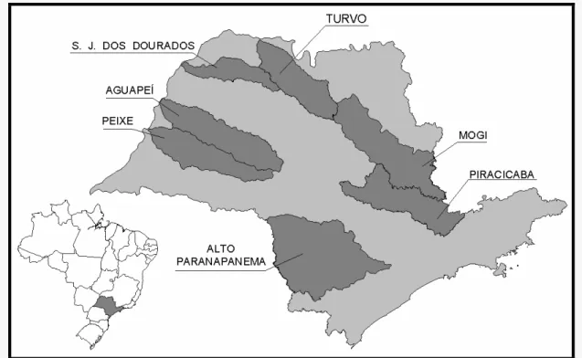
The study area covers seven meso-scale basins mainly located in the State of São Paulo (Brazilian southeastern region) (Fig. 1). It is the most developed state of the Brazilian territory and it is also the most populated Brazilian State (www.ibge.gov.br).
Fig 1. Location of São Paulo State in Brazilian territory (small map – lower left), and the seven river basins that are the study areas.
The river basins Alto Paranapanema, Aguapeí, Peixe, São José dos Dourados, Mogi, Turvo and Piracicaba are fully located in the State of São Paulo, except Mogi and Piracicaba where about 10% and 9%, respectively, are located in the State of Minas Gerais. In the text the river basins are characterized by the following abbreviations: Alto Paranapanema (ALPA), Aguapeí (AGUA), Peixe (PEI), São José dos Dourados (SJD), Mogi (MOG) and Turvo (TUR).
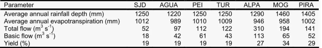
Table 1 presents some hydrological characteristics of the studied areas (São Paulo, 1990). The hydrographic map containing the main rivers located in the State of São Paulo is available at: www.biota.org.br.
According to database available in www.cetesb.sp.gov.br (Company of Technology for Environment and Sanitation of State of São Paulo), the surface water resources of the SJD, AGUA, PEI, ALPA and TUR are classified as regular / good for the mostly observed monitoring points (according to Water Quality Index performed by Cetesb for both public supply and wildlife). On the other hand, the superficial water of MOG and PIRA are considered regular / poor, mainly due the very high demographic concentration existing in these river basins and due the high industrial concentration, where the sewage (domestic and industrial) is poorly treated.
Caminhos de Geografia 3 (17) 20 - 30, fev/2006 Página 23
Table 1
Hydrological characteristics of the study areas
Parameter SJD AGUA PEI TUR ALPA MOG PIRA
Average annual rainfall depth (mm) 1250 1220 1250 1250 1290 1460 1405 Average annual evapotranspiration (mm) 1012 989 1010 1009 946 958 1002
Total flow (m3 s-1) 52 97 112 122 310 194 141
Basic flow (m3 s-1) 18 42 61 43 113 65 52
Yield (%) 19 19 19 19 27 34 29
Source: São Paulo (1990)
Table 2 shows the predominant geologic and geomorphologic aspects of each river basin. Concerning to the geologic basement, the State of São Paulo is constituted by two main lithostratigraphic units: A) a crystalline basement in the eastern parts of the territory that encompasses very old metamorphic and igneous rocks (Precambrian crystalline rocks), like granites, shale, gneisses, amphibolites, and metasedimentary rocks; and Tertiary Cenozoic cover and coastal sediment. B) a Paraná sedimentary basin with mainly sandstones and basaltic rock from volcanic eruptions, with local occurrences of siltstones, claystones and conglomerates of the Bauru, São Bento, Passa Dois, Tubarão and Paraná geological formations (Almeida, 1974). The river basins PEI, AGUA, SJD and TUR are totally constituted by sedimentary basement, while the river basins ALPA, MOG and PIRA are mainly originated by crystalline basement with small portions of sedimentary origin.
Table 2
Geological basement and geomorphologic aspects of the study áreas River basin Geological basement Geomorphologic aspects
ALPA Sedimentary in a major part, with crystalline basement in the south portion
Relief steeped in high parts. Relief with medium topographic variation in the middle parts and with smooth slopes near to estuary
AGUA Totally sedimentary Relief softly waved with smooth slopes SJD Totally sedimentary Relief softly waved with smooth slopes PEI Totally sedimentary Relief softly waved with smooth slopes MOG Sedimentary in a major part, with crystalline basement in the eastern portion
(20% of whole area)
Relief steeped in high parts. Relief with medium topographic variation in the middle parts and with smooth slopes near to estuary
TUR Totally sedimentary Relief softly waved with smooth slopes PIRA Sedimentary in a major part, with crystalline basement in the eastern portion
Relief steeped in high parts. Relief with medium topographic variation in the middle parts and with smooth slopes near to estuary
Sources: IPT (1981), www.sigrh.sp.gov.br
Geomorphologically, AGUA, PEI, SJD and TUR show similar topographic aspects. These regions exhibit moderately waved relief with convex-flat slopes with a mean average declivity (≈15%). In the MOG, ALPA and PIRA river basins, geomorphological modifications can be noticed. Here, and mainly in the ALPA, the relief is more waved than in the first mentioned group of river basins. The southern part of ALPA river basins also shows regions with high lands and steeped relief (São Paulo, 1981).
Morphometric characteristics of seven meso-scale river basins in state of São Paulo (southeastern Brazil)
Alexandre Marco da Silva, Uwe Herpin, Luiz Antonio Martinelli
Caminhos de Geografia 3 (17) 20 - 30, fev/2006 Página 24
METHODS
Morphometric characterizations
Morphometric characterizations were performed by using maps of catchments perimeter and hydrograph. These maps were elaborated by Kronka (2002) and Silva (2001), and showed at “http://sinbiota.cria.org.br/atlas”. These maps (for each river basin) were on-screen digitalized using digital satellite imageries (Landsat 5 – TM, bands 3, 4, and 5) and using GIS technology (software Arcview 3.1 (ESRI, 1996) and IDRISI 3.2 (Eastman, 2001)). An exception was made for Piracicaba River basin, whose digital hydrographic map was obtained on “Piracena website” (www.cena.usp.br/piracena).
The following parameters were quantified: area, perimeter, total length of all channels and length of main channel. The quantification of each parameter was done according to mathematical equations showed by Christofoletti (1969) and Silva (1999). The data of MOG were obtained from Gandolfi (1971).
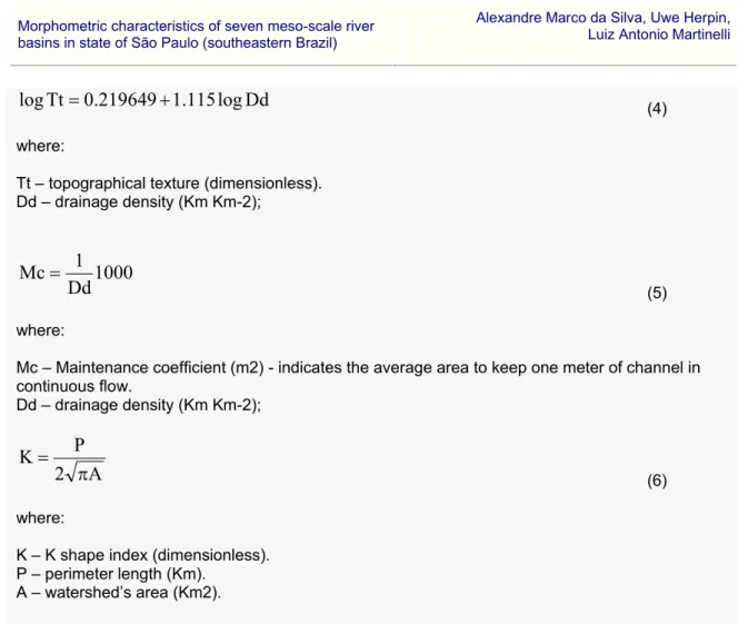
The parameters area, perimeter (perimeter length), total length of all channels and total length of the principal channel were obtained by using the digital map of the boundaries and the digital hydrographic map of each river basin. The number of 1st order channels and the network river were manually determined. The river density, drainage density, average length of overland flow, topography texture, maintenance coefficient, and shape index “K” were obtained by using the equations (1) to (6):
A
Nc
Rd
=
(1) where:Rd – River density (number of channels Km-2); Nc – number of first order channels;
A – area of the watershed (Km2).
A
.
L
.
C
.
T
Dd
=
(2) where: Dd – drainage density (Km Km-2); T.L.C. – total channels length (Km). A – area of the watershed (Km2).1000
Dd
2
1
Alof
=
(3) where:Alof - average length of overland flow (meters). Dd – drainage density (Km Km-2);
Caminhos de Geografia 3 (17) 20 - 30, fev/2006 Página 25
Dd
log
115
.
1
219649
.
0
Tt
log
=
+
(4) where:Tt – topographical texture (dimensionless). Dd – drainage density (Km Km-2);
1000
Dd
1
Mc
=
(5) where:Mc – Maintenance coefficient (m2) - indicates the average area to keep one meter of channel in continuous flow. Dd – drainage density (Km Km-2);
A
2
P
K
π
=
(6) where:K – K shape index (dimensionless). P – perimeter length (Km).
A – watershed’s area (Km2).
For the k shape index, the value equal 1.0 corresponds to a perfectly circular shape, and as far of 1.0, as far to a perfectly circular shape.
Statistical analyses
Statistical analyses (correlations and cluster analysis) were computed using the Statistica software (StatSoft, 1999) between the morphometric parameters and between the morphometric and hydrologic parameters. Correlation tests (Pearson’s test) were carried out on a significance level of 5%. The cluster analysis was done using the Ward’s method as linkage rule and “1 - Pearson’s r” as distance measure option.
RESULTS AND DISCUSSION
Table 3 shows the values of the morphometric parameter. In the present study the principal factor that seems act upon the morphometrical features is the rock type, which is clearly delineated by the geomorphologic provinces (Almeida, 1974). As shown in Table 2, the ALPA, MOG and PIRA river basin are partially located in a region whose geological basement is composed by crystalline or sedimentary rocks, with less permeability and with an expressively dissected relief. On the other hand, the AGUA, PEI, SJD and TUR river basins are totally located in regions where the geological basement is composed by permeable rocks, with a plane or smoothly waved and poorly dissected relief (Christofoletti, 1969; Almeida, 1974).
This may be the reason that the ALPA river basin presented the highest area value and also showed, jointly with PIRA and MOG, elevated values for river network. On the other hand, SJD river basin presented the highest values for the parameters “maintenance coefficient” and “average length of overland flow”.
Morphometric characteristics of seven meso-scale river basins in state of
São Paulo (southeastern Brazil) Alexandre Marco da Silva, Uwe Herpin, Luiz Antonio Martinelli
Caminhos de Geografia 3 (17) 20 - 30, fev/2006 Página 26
Table 3
Values of the morphometrical parameters of each river basin
Parameter Unit SJD AGUA PEI ALPA TUR MOG PIRA
Area km2 5,158.987 12,209.699 10,127.349 22,823.731 9,880.861 17,532.100 12,941.090
Perimeter km 483.254 674.218 626.748 858.953 576.045 913.000 911.263
Channel number Number of rivers 1,847.0 7,213.0 5,756.0 16,756.0 4,961.0 14,985.0 14,298.0
River network Order 6th Order 7th Order 6th.Order 8th Order 7th. Order 8th Order 8th Order
Total length channels km 4,493.403 12,918.445 9,965.463 27,878.899 9,518.381 17,797.000 21,361.990
Principal channel length km 301.746 468.972 372.178 420.584 382.000 330.000 455.500
River density 1st order class rivers/km2 0.358 0.591 0.568 0.734 0.502 0.855 1.105
Drainage density km of river / km2 0.871 1.058 0.984 1.221 0.963 1.010 1.651
Aver. Length of overland flow Meters 574.062 472.568 508.122 409.337 519.041 495.050 302.900
Topography Texture Dimensionless 1.422 1.766 1.629 2.073 1.591 1.677 2.900
Maintenance coefficient m2/m 1,148.125 945.137 1,016.245 818.674 1,038.082 990.099 605.800
Shape index "K" Dimensionless 1.898 1.722 1.757 1.604 1.635 1.946 2.260
Table 4
Values of “r” for each correlation computed between each morphometrical and/or hydrologic parameters (bold values: α = 5% significant, n=7).
Perim Shp K R Net TCl Ch N Hyd D LMC Dr D Alof Top T Mn C Rain T Fl B Fl Yield Evap
Area 0.80 -0.17 0.81 0.92 0.91 0.56 0.33 0.37 -0.51 0.36 -0.51 0.43 0.95 0.91 0.89 -0.94 Perim *-* 0.41 0.87 0.90 0.92 0.89 0.64 0.78 -0.86 0.77 -0.86 0.58 0.69 0.61 0.54 -0.64 Shp K *-* 0.24 0.07 0.19 0.61 0.30 0.60 -0.51 0.61 -0.51 0.53 -0.26 -0.40 -0.34 0.21 R Net *-* 0.87 0.93 0.82 0.32 0.65 -0.72 0.64 -0.72 0.71 0.80 0.60 0.66 -0.73 TCl *-* 0.96 0.75 0.46. 0.69 -0.79 0.68 -0.79 0.48 0.89 0.85 0.81 -0.79 Ch N *-* 0.84 0.33 0.65 -0.74 0.64 -0.74 0.70 0.89 0.78 0.78 -0.82 Riv D *-* 0.39 0.87 -0.89 0.87 -0.89 0.80 0.56 0.41 0.34 -0.39 LMC *-* 0.55 -0.63 0.54 -0.63 -0.16 0.10 0.20 0.01 -0.14 Dr D *-* -0.98 1.00 -0.98 0.47 0.35 0.31 0.20 -0.14 Alof *-* -0.98 1.00 -0.46 -0.48 -0.44 -0.31 0.27 Top T *-* -0.98 0.48 0.35 0.30 0.19 -0.13 Mn C *-* -0.46 -0.48 -0.44 -0.31 -0.27 Rain *-* 0.50 0.24 0.35 -0.43 T Fl *-* 0.93 0.92 -0.88 B Fl *-* 0.89 -0.80 Yield *-* -0.93
Abbreviations – perim: perimeter; Shp K: shape K index; R Net – river network; TCl: total channel length; Ch N: channel number; Riv D: river density; LMC: length of main channel; Dr
D: drainage density; Alof: average length of overland flow; Top T: topographic texture; Mn C: maintenance coefficient; Rain: annual rainfall depth; T Fl: total flow; B Fl: basic flow; Evap: evapotranspiration.
Caminhos de Geografia 3 (17) 20 - 30, fev/2006 Página 27
The K shape index of the ALPA River basin (1.604) indicates that the shape of this river basin is the nearest of a perfectly circular shape (K = 1.00, Christofoletti (1969)) among all river basins and PIRA river basin value is the more distant (2.260) of this perfectly circular shape. According to Zǎvoianu (1985), the actual surface of any drainage basin is the result of a long evolution process. In this process, a dynamic equilibrium between the general flows (of matter and energy) and the factors which define the behavior of the basin towards these flows has been achieved. In this context, there are two groups of factors influencing this development in different ways. On the one hand, there are the agents (e.g. climate, solar radiation) which act as forces that tend to lower the basin surface continuously. On the other hand, there are factors which resist this morphogenetic process, giving unity to the whole basin and continue the process of adaptation to achieve dynamic equilibrium.
For the parameter “river density”, the values determined in the present paper (ranging from 0.36 rivers km-2 in SJD to 1.1 rivers km-2 in PIRA) were smaller than the average value for the Poços de Caldas region (1.64 rivers km-2), that is totally constituted by igneous basement (Christofoletti, 1970). For the “drainage density”, Christofoletti (1970) found, for the same area, an average value of 1.87 km of river km-2, while in the present study we found smaller values (ranging from 0.81 km of river km-2 in SJD to 1.65 km of river km-2 in PIRA). These differences elucidate the influence of the geological basement on the superficial hydrographic richness.
The results of the correlation analyses are shown in Table 4. The parameters “length of the main channel” and “K shape index” showed no significant correlations with other parameters. The parameter “area” presented significant correlations with four morphometrical parameters (perimeter, river network, total channel length and channel number), and with four hydrological parameters (total flow, basic flow, yield and evapotranspiration). The highest correlation coefficient (r2 = 0.90) was verified between “area” and “total flow”, whose regression equation is presented in Table 5.
Table 5
Equations generated expressing the relationship among some parameters and their respective correlation coefficients values
Independent variable (x) Dependent variable (y) Equation R2
Area Perimeter Y = 9.1051x0.4633 0.80
Area Total length channels Y = 1.2894x-1838.7 0.85
Area Total number channels Y=0.9256x-2577 0.83
Area Total flow Y = 0.0141x-35.21 0.90
Total length channels Total flow Y=0.0094x+7.3997 0.80 Total number channels Total flow Y=0.0122x+31.807 0.72
The correlations between morphometric and hydrological parameters showed that the parameters “area”, “total channel length” and “channel number” are significantly correlated with almost all hydrological parameters studied (except with parameter “rainfall”). This parameter (“rainfall”) was only significantly correlated with the parameter “river density”. Evapotranspiration was significantly (negatively) correlated with the parameters “area”, “total channel length”, “channel number”, “total flow”, “base flow” and “yield”. Only the correlation with “K shape index” and “average length of overland flow” showed positive coefficients.
“Evapotranspiration” presents a particular nature of matter and energy output from a drainage area. This particularity is normally due to others non geological parameters, like the vegetation cover percentage. For instance, one general factor that determines this phenomenon is the amount
Morphometric characteristics of seven meso-scale river
basins in state of São Paulo (southeastern Brazil) Alexandre Marco da Silva, Uwe Herpin, Luiz Antonio Martinelli
Caminhos de Geografia 3 (17) 20 - 30, fev/2006 Página 28
of solar radiation in a certain drainage basin, which depends of its location on the globe (Zǎvoianu, 1985).
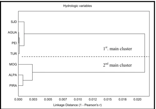
Fig. 2 (morphometric), Fig. 3 (hydrological), and Fig. 4 (morphometric + hydrological) show the clustering of the river basins according to similarity. In all figures a division in two main clusters can be verified. This is closely associated with the geological basement of the studied regions, verified through the geological data (Table 2) and visualized through the geological map (São Paulo, 1981). In Fig. 2 the first main cluster (indicated in the figure as 1st cluster) shows a high similarity between the river basins PEI and TUR, followed by AGUA. SJD river basin showed minor similarity to the other river basins expressed by higher linkage distance values. In the second main cluster, MOG and ALPA river basins are more similar, followed by the PIRA river basin.
In the main first cluster of Fig. 3, the river basins AGUA and PEI presented the highest similarity, followed by TUR and SJD watersheds. However, it is complex to differentiate which parameter actually influences these general results, because in terms of the “rainfall” and “evapotranspiration” data, the TUR and PEI river basin are more similar, whereas TUR and AGUA river basin indicate more similarity regarding the “basic flow” data.
The second main cluster showed in Fig. 3 presents the highest similarity between the ALPA and PIRA watersheds, followed by MOG river basin. There are also some uncertainties to detect the main influencing factor, because MOG and PIRA river basins are similar for the parameters “rainfall”, “total flow” and “basic flow”, and MOG and ALPA river basins for “evapotranspiration”. ALPA and PIRA river basins show the highest similarity for the parameter “yield”.
Fig. 4 presented approximately an identical design of the tree plot as in Fig. 2, suggesting that morphometric parameters seem to have more influence on the design than hydrological parameters. According to Zǎvoianu (1985), many environmental factors appear be qualitatively distinct variables with well-defined relationships, but it is complex to separate and estimate them quantitatively.
Morphometric variables
Linkage Distance (1 - Pearso's r) PIRA ALPA MOG TUR PEI AGUA SJD 0.00 0.01 0.02 0.03 0.04 0.05 0.06 0.07 0.08 0.09 0.10
Fig. 2. Tree plot for morphometrical parameters. 2nd. main cluster 1st. main cluster
Caminhos de Geografia 3 (17) 20 - 30, fev/2006 Página 29 Hydrologic variables
Linkage Distance (1 - Pearson's r) PIRA ALPA MOG TUR PEI AGUA SJD 0.000 0.003 0.005 0.007 0.010 0.012 0.015 0.018 0.020
Fig. 3. Tree plot for hydrologic parameters
Finally, it is important to comment that geological basement, which is the main factor that explains the relation among morphometry and hydrology for the studied river basins also explains the predisposition to erosive process along the State of São Paulo. The sedimentary geological basement permits that the water infiltration along the soil and /or rock profile is higher than on the crystalline basement. This result in some river basins with less richness of superficial water resources (AGUA, PEI, SJD and TUR river basins) and other with major richness (ALPA, MOG and PIRA).
Concerning to predisposition for erosion, it is important to explain that factors related to soil characteristics are more important than the topographic factors, especially for the AGUA, PEI, SJD and TUR river basins, whose soil is extremely fragile but the relief is softly waved.
CONCLUSIONS
In this study morphometric and hydrological parameters of the river basins PEI, AGUA, TUR, SJD, ALPA, PIRA and MOG were estimated.
On the study area (all the seven river basins) the water resource richness is good and allows the rural and urban development, although the drinking water use should be extremely well dimensioned and planned in order to prevent the water ration for population.
The “perimeter” was the morphometric parameter that showed the highest number of significant correlations with the other morphometric parameters. According to the correlation analyses, the hydrological parameter “rainfall” is not significantly related to the others hydrological parameters. Through the cluster analyses, it was verified the geological basement is the main factor that determines and explains the design and morphometrical features of the river basins.
Acknowledgements
The authors thank Francisco Kronka and Marco Nalon (Instituto Florestal de São Paulo) for 1st. main cluster
Morphometric characteristics of seven meso-scale river
basins in state of São Paulo (southeastern Brazil) Alexandre Marco da Silva, Uwe Herpin, Luiz Antonio Martinelli
Caminhos de Geografia 3 (17) 20 - 30, fev/2006 Página 30
providing data used in this study. They also thank the Fundação de Amparo à Pesquisa do Estado de São Paulo (FAPESP) for financial support (process number 00/12.939-0).
REFERENCES
Almeida, F.F.M., 1974. Fundamentos geológicos do relevo paulista. Série Teses e Monografias no 14, IG-USP. São Paulo-SP-Brazil, 99 p.
Christofoletti, A., 1969. Análise morfométrica das bacias hidrográficas. Notícia Geomorfológica 9, 35-64.
Christofoletti, A., 1970. Análise morfométrica das bacias Hidrográficas do Planalto de Poços de Caldas (MG). Tese de Livre-Docência. Faculdade de Filosofia Ciências e Letras. Rio Claro - SP. 215 p.
Christofoletti, A., 1974. Geomorfologia. Editora Edgard Blücher, São Paulo, SP, 149 p. Christofoletti, A., 1981. Geomorfologia Fluvial. Editora Edgard Blücher, São Paulo, SP, 313 p. Christofoletti, A., Guerra, C.E.C., Magnavita, I.M.P., Martins, M.R., Tavares, A.C., 1981. Contribuição à análise morfométrica das regiões das bacias do Jequitinhonha e Extremo Sul, no estado da Bahia. Notícia Geomorfológica 21, 61–84.
Eastman, J.R., 2001. Idrisi 3.2 - Release 2: Tutorial. Worcester, Massachusetts. Clark University. ESRI, 1996. Arcview GIS – The Geographic Information System for Everyone. Version 3.1, 350 p. Gandolfi, N., 1971. Investigações sedimentológicas, morfométricas e físico-químicas nas bacias do Mogi-Guaçu, do Ribeira e do Peixe. Tese (Livre-Docência). Departamento de Geologia e Mecânica dos Solos. Escola de Engenharia de São Carlos – USP. São Carlos – SP. 108 p.
Kronka, F.J.N., 2002. Inventário Florestal das Áreas Reflorestadas do Estado de São Paulo. Secretaria do Meio Ambiente / Instituto Florestal. São Paulo, SP.
Moussa, R., 2003. On morphometric properties of basis, scale effects and hydrological response. Hydrological Processes 17, 33–58.
Pidwirny, M.J., 2000. Fundamentals of Physical Geography. Web site address: http://www.geog.ouc.bc.ca/physgeog/contents/11l.html
São Paulo, C.E.R.H., 1990. Plano Estadual de Recursos Hídricos. 1st State Planning for Water Resources for São Paulo, 140 p.
São Paulo, I.P.T., 1981. Mapa Geológico do Estado de São Paulo. Escala 1:1.000.000. Publication IPT number 1,184.
Silva, A.M., 1999. Aplicações de técnicas de geoprocessamento no estudo das relações entre os processos erosivos e sedimentológicos de bacia hidrográfica. São Carlos. EESC-USP. Doctorate thesis, 249 p.
Silva, A. M. 2001. Mapeamento da cobertura e uso do solo para as Bacias Hidrográficas do Alto Paranapanema, Aguapeí, Peixe/Santo Anastácio e São José dos Dourados, a partir de imagens de satélite. Annual report of the research project (FAPESP grant 00/12939-0). No published data. Statsoft, Inc., 1999. Statistica for Windows [Computer program manual]. Tulsa. OK. Website address: http://www.statsoft.com
Tucci, C.E.M., 1997. Hidrologia - Ciência e Aplicação – Porto Alegre - RS. Editora da Universidade (UFRGS) / Edusp / ABRH, 943 p.
Zǎvoianu, I., 1985. Morphometry of Drainage Basins. Developments in Water Science 20. Elsevier, Bucharest - Romania, 238 p.