FREE THEMES
1 Departamento de Estudos sobre Violência e Saúde Jorge Careli, Escola Nacional de Saúde Pública (ENSP), Fiocruz. Av. Brasil 4036/7º, Manguinhos. 21040-210 Rio de Janeiro RJ Brasil. [email protected] 2 Laboratório de
Monitoramento de Grandes Empreendimentos, ENSP, Fiocruz. Rio de Janeiro RJ Brasil.
Murder and actual bodily harm in Itaborai, Brazil:
analysis at different scales
Abstract An ecological study aimed at analyz-ing homicide rates and actual bodily harm was conducted in Itaboraí, in the years 2010 to 2011. The entire municipality was used in the study covering critical and non-critical areas. The data came from the Information System for the Public Security Institute in Rio de Janeiro state. The ter-ritories were identified and defined by referring to studies on illegal occupations of areas. The snow-balling method was used for the social recognition of poor conditions. The morphological differen-tiation of urban and housing standards marked the locations. The areas were georeferenced, and the problems were located geographically and or-ganized according to their corresponding critical area. We calculated the municipal rates using population estimates from IBGE. For the crit-ical areas, we obtained estimates of the number of households multiplied by a factor equal to the average household density in the corresponding census tract. There was a decrease in homicide rates and a rise in actual bodily harm in Itaboraí. We also found that there was an increased risk of bodily injury in critical areas with the worst liv-ing conditions, suggestliv-ing the existence of social inequalities that make certain social spaces more vulnerable to incidents involving violent injuries. Key words Homicide, Injury, Assault, Violence, Spatial analysis
Edinilsa Ramos de Souza 1
Heitor Levy Ferreira Praça 2
Eliane Santos da Luz 2
Paulo Chagastelles Sabroza 2
Souza ER
Introduction
The implementation of a major commercial enterprise such as the Rio Petrochemical Com-plex, Complexo Petroquímico do Rio de Janeiro/ COMPERJ in the eastern region of Rio de Janei-ro has bJanei-rought about major socioenviJanei-ronmental transformations1. In order to check the
hetero-geneity of the areas and its relations with the health situation, epidemiological monitoring of the commercial enterprise is taking place. In the ambit of this monitoring, we analyzed the inci-dents of actual bodily harm and murders in the municipality of Itaboraí and in specific areas in this municipality that presented poor sanitary, living and economic conditions which we called critical areas2,3.
The search for inter-relations between liv-ing conditions and health is not a recent search; pioneers in this area produced studies on the above in the 19th century. Subsequently with the advent of the “bacteriological era”, such studies increased in intensity and there was a marked increase in the 1950s “emphasizing the relations between health levels and socioeconomic factors, principally in relation to the theme of health and development”4.
The studies are theoretically based on the presence of inequality in health for certain pop-ulation groups, which is a reflection of the differ-ent living conditions demonstrated in the classic research findings produced by Villermé and En-gels. According to Paim4, these studies provide an
explanation for the health conditions.
based on the relations between the development of productive forces connected to industrialization and the social processes such as: urbanization, the agrarian question, migrations and the formation of the so-called reserve army of labor, meaning the population surplus exposed to poverty and serious health problems.
Based on this assumption, this idea is very well summarized by Castellanos7 (apud Paim4),
that:
each individual, family, community and pop-ulation group in every moment of their existence, have necessities and risks that are characteristic to them, based on their age, sex and on other individ-ual attributes such as geographical and ecological locality, culture, level of education or economic-so-cial standing which translates itself into health problems/peculiar diseases and which can either be favorable to them or, to a greater or lesser extent, make their being an fulfilled individual difficult in-cluding realizing social projects.
As a methodological alternative to access the different living conditions of the populations, ecological studies on specific areas were used as units of analysis and they were compared with each other to identify socio-spatial inequalities and health conditions4-7.
Barcellos et al.6 working in a similar
theoreti-cal vein concerning the methodologitheoreti-cal resource of space stated:
if the disease is a manifestation of the individ-ual, the health situation is a manifestation of the place. The places inside of a city or region, are the result of an accumulation of historical, environ-mental and social situations that promote particu-lar conditions for the production of diseases.
They highlighted the importance of the “de-velopment of indicators that can detect and re-flect conditions that present health risks based on the environmental and socially adverse con-ditions”6, for the diagnosis of the differences in
health situations.
In general, the studies described as “ecolog-ical”, use indicators that come from censuses or health reports that, due to how they have been obtained, end up limiting the construction of the territorial units to be analyzed8,9.
In the ambit of the Plan for Epidemiological Monitoring of the Process for the Implementa-tion of COMPERJ2, there were two with
com-plementary ones that employed methodological tools to investigate the influence of the popula-tion’s living conditions in the municipalities cov-ered by the research in relation to worsening peo-ple’s health for those that were being monitored. The first consists of the socioeconomic strat-ification of the boroughs and census sectors in the municipalities of Itaboraí, Guapimirim and Cachoeiras de Macacu grouped in Local Surveil-lance Units (UVL). This was done in accordance with the indices composed of urban installations and social structures in order to cross reference the information on the notification of assaults and deaths. The UVLs are territorial units for analysis created based on an agglomeration of census sectors. The Demographic Census from IBGE10 is the primary database that has
aúd
e C
ole
tiv
a,
23(2):463-470,
2018
The second idea that this paper is based on, consists in the identification of the critical areas that are localities that have the worse living con-ditions in the ambit of the municipalities that were covered and monitored and in the checking of the distribution of assaults in these areas.
The search for another perspective for the recognition of living conditions comes from our concordance with criticism in the use of social indicators obtained through the aggregation of data on the population. These indicators have as an assumption, the internal homogeneity of the territorial units, but according to Barcellos7,
these assumptions are false, being the result of a simplification of structure and dynamics in the geographic space. Various studies have shown that there is not always a linear and direct correlation between poverty and poor health conditions. In some cases, to the contrary, areas with higher num-bers may increase the risks of health of their resi-dents.
The acceptance of this hypothesis easily takes us to the conclusion that these areas would not be homogenous as assumed by the aggregated analysis methodology (ecological speaking), but extremely differentiated internally.
Thus, in relation to the panorama provided by the secondary data referring to living condi-tions and health at territorial scales in the mu-nicipality in Itaboraí, the intention was to bring together another perspective given through the search for information with technicians from the city councils in the municipalities and field work, for the recognition of living conditions in the lo-cal ambit. This means the intention was to ana-lyze the relations between living conditions and health conditions based on two complementary scales: municipal and the other based on small local units of analysis called critical areas.
In this way, the present study presents itself as an attempt, in the face of the challenge, to bring to light some of the silenced internal differenc-es in the midst of homogenization owing to the construction of social indicators for municipal territorial units, to refine the analysis of possi-ble correlations between living conditions and health conditions in the local units in the munic-ipality of Itaboraí.
Methodology
The purpose of this ecological study was to an-alyze the rates of murders (fatal aggression) and actual bodily harm (none fatal aggression) in
Itaboraí between 2010 and 2011. These acts were chosen as they are characterized by: violence against someone, their gravity and because they are indicators for social violence11,12. In addition
to this, the offence of actual bodily harm has been registered the most amount of times by the police.
The information relative to actual bodily harm and murders came from the Information System for the Public Security Institute in state of Rio de Janeiro. It was taken from the police re-ports made at the police stations which had been placed on the system.
Two spatial scale analysis were used: the mu-nicipality and its parts and three analysis units. These included the municipality, critical areas and the localities without critical areas in the same municipality.
The critical territories were initially identified through the review of studies on urban condi-tions in the municipality (including the Direc-tor’s Plan for the Municipality of Itaboraí and the Strategic Municipal Plan for Informal Urban Settlements - PEMAS) principally those referring to the existence and location of illegal occupa-tions and through the social recognition of the worse conditions using the snowballing13 method.
Thus, the areas were identified by the research-ers through field work in the identified localities based on dialogs with: technicians from the city council, residents in illegal occupations indicated by the technicians and residents of other areas in the municipality indicated by the residents of these occupations.
Later on, in the study, we went to these lo-calities to conduct physical recognitions and to outline the geographical limits through the pro-cess of morphological differentiation of urban standards of living in the localities to which the researchers were taken by the participants. These areas were georeferenced.
Geographical localization was done for the investigated incidents based on the variable pub-lic places placed on the databases used. The data was organized by the names of roads and sub-sequently classified in accordance with its corre-sponding critical area.
To calculate the municipal rates, population estimates from IBGE10 were used and for
popula-tion estimates in the critical areas, the number of habitations was calculated with a multiplication by a factor equal to the average household densi-ty in the corresponding sector census.
Souza ER
covered the critical areas and the rest of the lo-calities in the municipality without critical areas.
In relation to the comparison of rates between years and areas, the incidents under analysis may be considered as being subject to random varia-tions and in this way, requires the calculation of confidence intervals14. Where the numerator rate
was less than 100 incidents, we used the Poisson distribution for calculating the confidence inter-vals of 95%. For the rest of the cases, the normal distribution of probability was used. In the com-parison of rates whose numerator was less than 100, a superposition of the intervals of confi-dence, indicated that the observed difference was not statistically significant. For cases in which the numerator of the rates was greater than 100, we calculated a test statistic of z and this was consid-ered not to be significant when |z| <1.9614.
A brief description of the municipality of Itaboraí
This municipality is located in the state of Rio de Janeiro on the north-east part of the Guanaba-ra bay. It is a part of the Metropolitan Region of Rio de Janeiro encompassing the hydro-graphic basin of the Caceribu River. It has an area that is approximately 428.6 km². To the north, it borders the municipalities of Guapimirim and Cachoeiras de Macacu. To the south, it borders Maricá. To the west, it borders São Gonçalo and Baia de Guanabara and to the east it borders Tan-guá (the old district of Itaboraí that became in-dependent in 1995). Its territory is divided into eight districts: Itaboraí, Porto das Caixas, Itambi, Sambaetiba, Visconde de Itaboraí, Cabuçu, Ma-nilha and Pachecos.
According to the Census data for 201010, its
total population was 218,008 inhabitants of whom, 98.8% resided in the urban areas. Wom-en were the predominant sex making up 51.3% of the total population. Also, according to the aforementioned Census10, 57.7% of the
popula-tion was aged between 20 to 59 years old and only 10.3% were over 60. The population was over-whelming made up of young people.
In the first decades of the 19th century with the expansion of the coffee plantation, Itaboraí acquired a level of importance and relevance for having a route for the soldiers that brought cof-fee from Cantagalo, Cordeiro and Nova Friburgo going towards the Macacu river and taking it to Porto das Caixas and then on to Rio de Janeiro. However, from 1950s the production of coffee was hit by a crisis and the municipality of
Itab-oraí went back to cultivating oranges15, in part,
as a response to the expansion of the market and thanks to the development of the cities of Niterói and Rio de Janeiro.
The construction and paving of the highways was also an important factor that had a dynamic economic impact on the population of this re-gion. Amongst them were the highways: RJ-104, BR-493 and BR-116. It is worth mentioning that in 1970 there was the occurrence of a major event that drastically changed the whole social and eco-nomic dynamism in the region accelerating the process of urbanization and principally impact-ing on the municipality of Itaboraí. This was the construction of the Rio-Niterói bridge that was opened in 197416.
The pottery industry also played an import-ant role in the economy of this municipality. It was boosted by the arrival of the royal family to Brazil. However, this economic activity started to decline in the 1970s resulting in the down turn of industrial production17.
During the 90s there was a serious citriculture crisis which was the municipality’s main activity, due to pests. This factor produced major losses in the rural economy of Itaboraí with the transfor-mation of the district of Tanguá in the munici-pality (taking with it the greater part of the rural output of Itaboraí) and it caused a significant fall in agricultural activity in the municipality.
The recent analysis of the characterization of the economic activity in the municipality showed that the municipality is strongly based on the ter-tiary sector and services which makes up 62.0% of the GDP. This sector has grown and attracted new companies such as electrical domestic and furnisher stores and a chain of snack bars. The secondary sector in the economy can also be high-lighted with particular reference to civil construc-tion and the transformaconstruc-tion of industries, each of which has been contributing up to 9% of the mu-nicipal’s GDP. It should also be highlighted that to corroborate the findings of the fall in agricultural activity, a notable fact in the primary sector is that it has not reached 1.0% of the GDP17.
In terms of territorial occupation, the critical areas correspond to 4.1% of the total territory occupied in the municipality of Itaboraí and in this area 7.4% of the inhabitants live there.
Results
aúd
e C
ole
tiv
a,
23(2):463-470,
2018
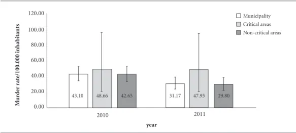
greater than what was observed in the munici-pality as a whole (43.1/100.000 inhabitants, 94 incidents), and 14.3% greater than the rate in the localities without critical areas (42.6/100.000 inhabitants, 86 incidents). In 2011, the rate for these incidents in critical areas (48/100.000 in-habitants, 8 incidents) was 53.8% greater than the rate in the municipality (31.2 per 100.000 inhabitants, 69 incidents) and when compared to the rate in the territory without critical areas (29.8/100.000, 61 incidents) the difference was even greater (61.1%) as shown in Graphic 1. The differences observed however, were not statisti-cally significant.
It is important to highlight the absolute num-bers, as the rate of murders fell between 2010 to 2011 in the units of analysis and in the localities without critical areas, but they remained practi-cally the same in the critical areas. In the munic-ipality, the rate fell by 27.6% and in the localities without critical areas the fall was 30%. However, we did not see any significant statistical differ-ence between the rates.
In Graphic 2 in 2010 the rate of actual bodily harm in the critical areas (577.9/100.000 inhab-itants, 95 incidents) was 20% greater than what was observed in the municipality as a whole (481.5/100.000 inhabitants, 1050 incidents), and 22% greater than the rate in the localities with-out critical areas (473.6/100.00 inhabitants, 955 incidents). In the following year, the difference was even more accentuated: the critical areas pre-sented a rate of (701.3/100.000 inhabitants, 117 cases) 26.1% greater than that in the municipal-ity (556.1/100.000 inhabitants, 1231 cases) and
41.6% greater than a rate in the localities without critical areas (495.4/100.000 inhabitants, 1014 cases). The comparison of the rates between the areas for the year 2010 showed that there was no significant difference. For the following year however, the differences observed were statisti-cally significant.
In the period, we observed increases in the rates in three units of analysis, with there being greater intensity in the critical areas (21.3%) compared to whole of the municipality (15.5%) and the non-critical areas (4.6%). We noted a sta-tistically significant difference only for the mu-nicipal rates.
Discussion
The present study sought to obtain new indica-tors for the analysis of violence that can identify intra-territorial heterogeneity and thus demon-strate the existence of distinct vulnerabilities determined by the different socioeconomic life conditions. The findings suggest the existence of social inequalities resulting from precarious living conditions that make certain social spaces more vulnerable to violent incidents4-7,18.
In the analysis presented here, we observed the reduction in the rate of murders and the in-crease in the rate of actual bodily harm in the municipality of Itaboraí; showing a possible change in the pattern of aggressive acts that were occurring which may indicate that they became less serious. This is something that requires a deeper study. One way of checking this
hypothe-Graphic 1. Annual rate of murders (per 100,000 inhabitants) in critical areas, non-critical areas and the municipality of Itaboraí with the respective rate of CI95%, 2010 and 2011.
2010 2011
year
M
ur
d
er r
at
e/100.000 inhabitants
0.00 20.00 40.00 60.00 80.00 100.00 120.00
43.10 48.66 42.65 31.17 47.95 29.80
Souza ER
sis would be to analyze the dynamic generators of the murders and actual bodily harm incidents as, for example, the involvement of incidents with narcotrafficking having a common criminality element or with crimes of passion such as aggres-sion against women, amongst others.
The national journals have been showing falls in the mortality rates for murders in the large Brazilian metropolises19,20 and increases in
cities around the capitals metropolitan regions – such as is the case for Itaboraí just like the cities in the outskirts of the states and in the border regions21-25. It would be important to monitor
whether the occurrence of a decline in the rates observed in the municipality studied was consis-tent. And, this being the case, to identify if and how this fall is related to the arrival of COMPERJ in the municipality and to the control of certain violent events as also with the increase of other types of aggression which was the case for actual bodily harm. In this study, we checked that the falls observed in the rates of murders were not statistically significant.
The violence shown here through lethal ag-gression and non-lethal agag-gression, appeared to show not just differences amongst the areas that were analyzed but we also noted a greater intensi-ty of the violence for those with poor living con-ditions. In this way in 2011, what can be noted was the existence of a greater risk of non-fatal aggression in the critical territories characterized by a lack of urban infrastructure. However, in agreement with some authors26,27, it is important
to explain that we do not want to incriminate
poverty stricken populations for having high levels of violence. On the contrary, these popu-lations have principally been the victims of these forms of violence that occur in the territories where they live. These areas are marked by pre-carious socioeconomic living conditions and so-cial instruments, but the principal lost is that of the protection for the residents and the guarantee of their citizenship rights.
In the years that were analyzed, even when there was a fall in the rate of murders in the mu-nicipality and in the non-critical areas, we ob-served an increase in this rate in critical areas. When there was an increase in the rate of actual bodily harm in the three areas, it was intense in the critical territories. This, once again, showed that these last areas are more vulnerable to these violent incidents.
Barcellos18 highlighted that the degree of
de-tail from the information depends on the scale of geographical analysis chosen and this choice is not arbitrary. His definition advocates the best way of reaching the objectives of the study and to respond to the question in the research. This has implications in just a part of the information that was analyzed since it is impossible to consid-er all of the existing elements on any given geo-graphical scale as well as the recognition of the geographical elements that ought to be includ-ed or excludinclud-ed in the study. For this reason, it is necessary to take care when studying associations amongst the risks of one particular and complex health problem that has many causes as is the case for violence and isolated variables28.
Graphic 2. Annual rate of actual bodily harm (per 100,000 inhabitants) in critical areas, non-critical areas and the municipality of Itaboraí with the respective rate of CI95%, 2010 and 2011.
2010 2011
year
B
o
dily har
m r
at
e/100,000 inhabitants
0.00 100.00 200.00 300.00 400.00 500.00 600.00 700.00 800.00 900.00
481.45 577.89 473.59 556.11 701.31 495.42
aúd
e C
ole
tiv
a,
23(2):463-470,
2018
Final Considerations
The methods and indicators used to analyze the acts of violence are not always sufficiently specif-ic and precise to detect inter and intra-regional differences, that many times are necessary to un-derstand these aggressive acts.
This study has shown that it is possible to obtain more detailed knowledge on creating a methodology and working with smaller scale analysis. However, it should be highlighted that this was the initial contribution and that any enhancements to the method here, needs to be done with a view to refining it.
There is a possibility that sub-registers exist in the number of violent incidents that were an-alyzed, bearing in mind that not all of the mur-ders and principally not all of the actual bodily harm acts that were registered by the police, can be taken as an under-estimation of the rates. In the same way, there may be inaccuracies in the population estimates, principally those related to the critical areas that were based on counting the number of households multiplied by the av-erage density of households from the census data where the critical areas were situated. This num-ber may have increased as the population went down in these areas, causing either a reduction in the risk or its increase.
Another important step ought to be looked at which is to analyze a larger historical series which may demonstrate a consistency or not in the re-sults that were found.
In any case is necessary to conduct a deeper analysis of this area as according to Gracie et al.28,
spatial studies affect the results that are obtained because each space on the scale used, has its own attributes. A geographical scale on using a certain unit of aggregated data, can show clear associa-tions that are not visible on other geographical scales. Thus, the same indicator can be positively or negatively correlated with an incidence of a violent act, for example, depending on the geo-graphical scale used. Therefore, as recommended by the authors, it is important to combine, visu-alize and analyze the data on different scales and decide which geographical scale should be used. Do not forget that it should be compatible with the studied phenomenon. However, this choice is never an easy one.
The municipality of Itaboraí and its critical areas are suffering from the influences of socio-economic and demographic transformations re-sulting from the installation of the Petrochemi-cal Pole COMPERJ. According to Rosa and
Or-doñez1, in 2010, this municipality attracted 50
thousand new residents totaling approximately 300 thousand inhabitants. The prediction was that in ten years-time the population would reach one million. Also, according to these authors, a study by the Federação das Indústrias in the state of Rio de Janeiro (Firjan) made the prediction that COMPERJ would attract between 320 and 700 industries to the municipality in the next five years. COMPERJ generated six thousand jobs in 2010 and in 2011 it was hoped that it would gen-erate approximately 10 thousand jobs. In the area of commerce, 160 new jobs were created in 2009. The city is experiencing a property explosion with an increase of 20% in the value of property which has not stopped increasing. This is a reflec-tion of the migratory flow. However, only a third of the population has access to a sewage system and basic sanitation.
It falls to the public authorities to act pro-actively with the objective of improving the so-cio-sanitary conditions in its most poverty strick-en territories with a view to reducing the effects of unplanned economic growth. This situation of a lack of state intervention has already occurred in other areas in Rio de Janeiro that went through similar experiences and its adverse effects are well known.
Collaborations
ER Souza, HLF Praça and ES Luz came up with the idea as well as analyzed and wrote the paper. PC Sabroza came up with the methodology used in the article. LW Pinto analyzed the data and wrote the text.
Acknowledgments
Souza ER
References
1. Rosa B, Ordoñez R. Com obras do Comperj, Itaboraí sofre ‘boom’ imobiliário e enfrenta os males da migra-ção. O Globo 2011; 09 Jan.
2. Toledo LM. Monitoramento da evolução das causas re-levantes de adoecimento, morte e de segurança pública nos municípios de Itaboraí, Guapimirim, Cachoeiras de Macacu e no Distrito de Monjolos: Relatório
técni-co-executivo XXIII. síntese anual 2012. Rio de Janeiro:
Fiocruz; 2013.
3. Toledo LM. Plano de Monitoramento Epidemiológico da Área de Influência do COMPERJ. Relatório técnico-exe-cutivo XXVIII: Monitoramento Epidemiológico das Cau-sas Relevantes de Adoecimento, Morte e de Segurança Pública nos Municípios de Itaboraí, Cachoeiras de Ma-cacu, Guapimirim e no Distrito de Monjolos (Município de São Gonçalo): síntese anula 2013. Rio de Janeiro: Fio-cruz; 2014.
4. Paim JS. Abordagens Teórico-Conceituais em Estudos de Condições de Vida e Saúde. Saúde. In: Barradas RB, organizadora. Condições de Vida e Situação de Saúde. Rio de Janeiro: Editora Abrasco; 1997. p. 276. 5. Castellanos PL. Epidemiologia, Saúde Pública, Situação
de Saúde e Condições de Vida. Considerações Concei-tuais In: Barata RR, organizadora. Condições de Vida e
Situação de Saúde.Rio de Janeiro: Ed. Abrasco; 1997.
p. 31-75.
6. Barcellos CC, Sabroza PC, Peiter P, Rojas LI. Organiza-ção Espacial, Saúde e Qualidade de Vida: Análise Espa-cial e Uso de Indicadores na Avaliação de Situações de Saúde. Inf. Epidemiol SUS 2002; 11(3):129-138. 7. Barcellos C. Os indicadores da pobreza e a pobreza dos
indicadores: uma abordagem geográfica das desigual-dades sociais em saúde. In: Barcellos C, organizador. A
Geografia e o Contexto dos Problemas de Saúde. Rio de
janeiro: Ed. Abrasco; 2008. p. 107-139.
8. Borrel C. Métodos utilizados no estudo das desigual-dades sociais em saúde. In: Barata RB, organizadora.
Condições de Vida e Situação de Saúde. Rio de janeiro:
Abrasco; 1997. p. 167-191.
9. Macintyre S, Ellaway A, Cummins S. Place effects on health: how can we conceptualise,operationalise and measure them? Soc Sci Med 2002; 55(1):125-139. 10. Instituto Brasileiro de Geografia e Estatística (IBGE).
Censo Demográfico 2010:Resultados do universo.
[In-ternet]. [acessado 2015 Mar 16]. Disponível em: http:// www.ibge.gov.br.
11. Brasil. Departamento de Análise de Situação de
Saú-de. Política nacional de redução da morbimortalidade
por acidentes e violências: Portaria MS/GM n.º 737 de
16/5/01, publicada no DOU n.º 96 seção 1E de 18/5/01.
[Internet]. Ministério da Saúde, Secretaria de Vigilân-cia em Saúde, Departamento de Análise de Situação de Saúde. 2ª ed. Brasília, DF: Editora do Ministério da Saúde; 2005. [acessado 2015 Mar 16]. Disponível em: http://bvsms.saude.gov.br/bvs/publicacoes/politica_ reducao_morbimortalidade_acidentes_2ed
12. Waiselfisz JJ. Homicídios e juventude no Brasil: Mapa da Violência 2013. Brasília: Secretaria Geral da Presidência da República; 2013.[acessado 2015 Fev 16]. Disponível em: www.juventude.gov.br
13. Explorable Psychology Experiments. Snowball
Sam-pling. 24 Apr. 2009.[Internet]. [acessado 2015 Mar 16].
Disponível em: https://explorable.com/snowball-sam-pling.
14. Matthews TJ, MacDorman MF, Thoma ME. Infant Mortality Statistics From the 2013 Period Linked Birth/ Infant Death Data Set. Natl Vital Stat Rep 2015; 64:1-30.
15. Neves DP. Os trabalhadores tangidos pelo gado. Tempo
1999; 4(7):47-69.
16. Magalhães LRL. O papel do transporte no desenvolvi-mento regional visto do outro lado da Ponte Rio-Ni-terói. Rev Rio Jan 2006; 18-19:1-256.
17. Itaboraí (RJ). Plano Estratégico Municipal para Assenta-mento Subnormais: Programa Habitar Brasil BID – Ita-boraí. Itaboraí 2003.
18. Barcellos C. Unidades y escalas en los análises espacia-les em salud. Rev Cuba Salud Pública 2003; 29(4):307-313.
19. Peres MFT, Vicentin D, Nery M, Lima RS, Souza ER, Cerda M, Cardia N, Adorno S. Queda dos homicídios em São Paulo, Brasil: uma análise descritiva. Rev.
Pa-nam. Salud Pública 2011; 29(1):17-26.
20. Souza ER, Lima MLC, Bezerra, EAD. Homicides in Brazil: Evolution and impacts. In: Lovisi GM, Mari JJ, Valencia ES, editors. The Psychological Impact of Living
under Violence. New York: Nova Science Publishers,
Inc; 2010. p. 1-14.
21. Souza TO, Souza ER, Pinto LW. Evolução da mortalida-de por homicídio no Estado da Bahia, Brasil, no perío-do de 1996 a 2010. Cien Saude Colet 2014; 19(6):1889-1900.
22. Sousa CAM, Silva CMFP, Souza ER. Determinantes dos homicídios no Estado da Bahia, Brasil em 2009. Rev. bras. epidemiol. 2014; 17(1):135-146.
23. Nery MB, Peres MFT, Cardia N, Vincentin D, Adorno S. Regimes espaciais: dinâmica dos homicídios dolosos na cidade de São Paulo entre 2000 e 2008. Rev Panam
Salud Publica 2012; 32(6):405-412.
24. Salla F, Alvarez MC, Oi AH. Homicídios na Faixa de Fronteira do Brasil, 2000-2007: Relatório de Pesquisa do
Projeto Violência e Fronteiras FAPESP/CNPq. São Paulo:
Núcleo de Estudos da Violência da USP (NEV/USP); 2011. [Internet]. [acessado 2015 Mar 17]. Disponível em: http://www.nevusp.org/downloads/down251.pdf 25. Silva JG, Valadares FC, Souza ER. O desafio de
com-preender a consequência fatal da violência em dois municípios brasileiros. Interface (Botucatu) 2013; 17(46):535-547.
26. Zaluar A, Noronha JC, Albuquerque C. Violência: Po-breza ou Fraqueza Institucional? Cad Saude Publica
1994; 10(Supl. 1):213-217.
27. Briceño-León R. La Comprensión de los Homicidios en América Latina: ¿Pobreza o Institucionalidad? Cien
Saude Colet 2012; 17(12):3159-3170.
28. Gracie R, Barcellos C, Magalhães M, Souza-Santos R, Barrocas PRG. Geographical Scale Effects on the Anal-ysis of Leptospirosis Determinants. Int J Environ Res
Public Health 2014; 11(10):10366-10383.
Article submitted 08/04/2015 Approved 13/01/2016
Final version submitted 15/01/2016
This is an Open Access article distributed under the terms of the Creative Commons Attribution License