www.scielo.br/rbg
APPLIED GEOPHYSICS ON A SOIL CONTAMINATED SITE BY CHROMIUM
OF A TANNERY IN MOTUCA (SP, BRAZIL)
L´ıvia Portes Innocenti Helene
1, C´esar Augusto Moreira
2and Leonardo Paioli Carrazza
1ABSTRACT.The management of contaminated sites includes the purchase of a data set ranging from the historical information of the occurrence, preliminary and detail diagnostic, monitoring and remediation. The settlement Monte Alegre located in Motuca (SP, Brazil) received an irregular disposal of waste of tannery leather on the soil surface in 2001 by the industries of the region. The tanning process involves the use of chromium salts, considered a carcinogen element in its hexavalent form. Based on preliminary evidence, the Environmental Agency of S˜ao Paulo State (CETESB – Companhia Ambiental do Estado de S˜ao Paulo) performed chemical analysis and recognized soil contamination in some lots. This study conducted geophysical surveys at one of these lots, the one that received the higher amount of leather (40 tons). The geophysical methods of resistivity and induced polarization conducted by 10 parallel lines of electrical tomography of Schlumberger array were used. The analysis of the environmental history of the field and geophysical results to characterize the presence of metal contaminants (Cr) in soil, which receive leather, indicated high chargeability (above 0.67 mV/V). More than one decade from the end of the disposal, it is still recognized clear indications of contamination in the soil by chromium, possibly due to its dissolution in rainwater, infiltration into the soil and complexion/retention by clay minerals.
Keywords: contamination, leather, resistivity, chargeability, 3D modeling.
RESUMO.O gerenciamento das ´areas contaminadas prevˆe o levantamento de um conjunto de dados que variam desde informac¸˜oes do hist´orico da ocorrˆencia, diagn´ostico preliminar e de detalhe, monitoramento e remediac¸˜ao. O assentamento Monte Alegre localizado no munic´ıpio de Motuca – SP foi alvo de disposic¸˜ao irregular de aparas de couro de curtume no solo em 2001. O processo de curtimento envolve o uso de sais de cromo, considerado cancer´ıgeno em sua forma hexavalente. Baseado em ind´ıcios pr´evios, a Companhia Ambiental do Estado de S˜ao Paulo (CETESB) realizou an´alises qu´ımicas no local e reconheceu a contaminac¸˜ao do solo em alguns lotes. O presente estudo realizou levantamentos geof´ısicos em um destes lotes, que recebeu a maior quantidade de aparas (40 toneladas). Foram utilizados os m´etodos da eletrorresistividade e da polarizac¸˜ao induzida, por meio de 10 linhas paralelas de tomografia el´etrica em arranjo Schlumberger. A an´alise conjunta do hist´orico ambiental da ´area e dos resultados geof´ısicos permite caracterizar a presenc¸a de contaminantes met´alicos (Cr) em faixas de solo que recebem leiras de aparas de couro, cuja presenc¸a de metal ´e indicada pela alta cargabilidade (acima de 0,67 mV/V). Decorridos mais de uma d´ecada, ainda s˜ao reconhecidos ind´ıcios de contaminac¸˜ao no solo por cromo, possivelmente devido `a dissoluc¸˜ao em ´aguas de chuva, infiltrac¸˜ao no solo e complexac¸˜ao/retenc¸˜ao por argilominerais.
Palavras-chave: contaminac¸˜ao, couro, resistividade, cargabilidade, modelamento 3D.
1Universidade Estadual Paulista – UNESP, Geoscience and Exact Science Institute, Geoscience and Environmental Science Graduation Program, Rio Claro Campus, 24-A Avenue, 1515, PO Box 178, ZIP code 13506-900 S˜ao Paulo, SP, Brazil. Phone: +55(19) 3526-2819 – E-mails: liviapihelene@gmail.com; leopcarrazza@hotmail.com
2Universidade Estadual Paulista – UNESP, Geoscience and Exact Science Institute, Applied Geology Department, Rio Claro Campus, 24-A Avenue, 1515, PO box 178, ZIP code 13506-900 S˜ao Paulo, SP, Brazil. Phone: +55(19) 3526-2819 – E-mail: moreirac@rc.unesp.br
i i
“main” — 2018/3/20 — 19:47 — page 310 — #2
i i
310
APPLIED GEOPHYSICS ON A SOIL CONTAMINATED SITE BY CHROMIUM OF A TANNERY IN MOTUCA (SP, BRAZIL) INTRODUCTIONThe distribution of chemical elements and minerals in the sub-surface is a result of several geological processes that can cause a dispersion or accumulation of elements in certain areas. Areas where the main process occurring was the concentration of min-erals can be defined as geochemical anomalies, which can feature mineral deposits with potential economic value. However, anthro-pogenic activities such as mining and industrial processes that manage some chemical elements can create these geochemical accumulations. Those unnatural anomalies can cause potential damage in the environment such as soil and water contamination (Bell, 1998).
Chromium is one of the metals that can reach the soil and groundwater and cause several environmental impacts due to it large use in industrial activities such as ore refining, metal cor-rosion inhibitors, ferrous and nonferrous alloys, leather tanning and others (Papp, 1994; Bielicka et al., 2005; USEPA, 2010).
Leather tanneries use chromium salts in the tanning process so it can transform animal’s skins into leather. About 90% of man-ufacture leather is made by tanning using chromium, which gives the skin a blue coloration from the salts (wet-blue) (ABDI, 2011). During the process of tannery, a large generation of wastewa-ter and solid waste contains chromium. Metals such as chromium cannot be removed from the effluents only by conventional treat-ment; and the amounts of solid waste are classified as dangerous and should have a correct destination (Moreira & Teixeira, 2003). According to studies on the mass balance in tanneries, for each ton of skin entering the process, only 250 kilograms are trans-formed into premium leather, the remainder are crust and waste (CETESB, 2005). Usually these waste ends up being in the envi-ronment for a long time, since they are not biodegradable and are disposed in irregular places without the proper treatment.
In this way, without the correct management, treatment and destination, the tannery can cause environmental impacts creat-ing contaminated sites.
The management of contaminated sites provides a protocol of steps that involves the previous record of the site, preliminary and detail investigation, succeeded by planning the remediation efforts and the monitoring program (CETESB, 2001). In soil and groundwater, chromium can be identified by quantitative data from the direct methods such as samples, or by indirect methods, that provides qualitative data from the contamination such as geo-physics.
Applied geophysics investigate structures, materials and ele-ments in the subsurface through indirect measureele-ments of phys-ical properties of underground, with no invasion to the environ-ment. Metals can change the natural electrical properties in the
environment under contamination, and can be detect by physical survey. Some studies show the use of electrical geo-physics methods in sites with soil and groundwater contaminated by chromium (Elis & Zuquette 2001; Nunes & Luiz, 2006; Fachin et al., 2006; Sankaram et al., 2009; Cunha & Shiraiwa, 2010; Ye et al., 2011).
The following study present a geophysical survey from a site with residual chromium of an improper release of leather crust in a rural settlement in Motuca (SP). The study take the environmental history of the location as reference to plan the geophysical sur-vey. In this way, it was conducted an electrical tomography using the resistivity and chargeability parameters to produce 2D profiles and 3D models.
LOCATION AND HISTORY
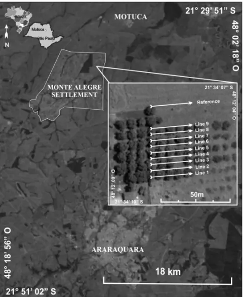
The study area is located in a rural settlement named Monte Ale-gre in Motuca, a city on the countryside of the State of S˜ao Paulo, 313 km away from its capital (Fig. 1). The settlement received an irregular disposal of tannery waste consisted in leather crust with blue aspects, which suggest that the crust has residual chromium. It was registered complaint at the environmental agency CETESB (Environmental Agency of S˜ao Paulo State) in 2002 and the mon-itoring program began (CETESB, 2013).
The disposal occurred in several areas of the settlement, in about 15 properties (reaching 1200 farmers from 19 families). With lack of information, the farmers used the waste as a growth organic compound to their crops. Once the farmers grew food, such as mango, lemon, orange, tangerine, sugar cane, corn and other vegetables with the organic compound and used to con-sume and sell it in groceries markets nearby, the situation became a potential public health problem.
The remediation work consisted only on the removal of the material in the soil surface; about 150 ton of waste removed be-tween the years of 2002 and 2003 were designated to a regular landfill. CETESB sampled groundwater from wells used for irri-gation and consumption of the farmers. The results showed that none of the well had a chromium concentration above 50µg/L, reference value to total chromium in water proper to consume.
Soil samples from some properties were analyzed in 2002 to detect the presence of total chromium. Some results presented concentrations above the limit allowed by CETESB, which clas-sifies the samples according to a reference value of 40 mg of chromium/kg. When the concentration reaches a level beyond 75 mg/kg the samples are considered in an alert value, and by the time it gets higher than 150 mg/kg, it is classified as an agri-culture intervention (CETESB, 2014).
Figure 1 – Location of Monte Alegre Settlement with detail of geophysical survey.
The illegal disposal caused a change in soil quality regarding chromium concentration. In this way, the farmers received a noti-fication about the contamination state of their lands and a formal request to stop the activities until the concentrations were normal-ized and did not represent a threat to them and the consumers.
The property studied in this work was the number 20. The concentration of chromium in the soil sampled by CETESB in 2002 presented the value of 85,3 mg Cr/kg soil, considered therefore as a state of alert. In the year of 2004, however, a new sample collected presented a value of 187 mg Cr/kg soil, which characterized the area as an agricultural intervention. The ana-lytical monitoring continued and the area remained in a state of alert according to the 2007 samples, which showed a chromium concentration of 85,88 mg Cr/Kg of soil in the first layers of soil (0-5 cm) and 54,26 mg Cr/Kg soil in depth (5-20 cm) (CETESB, 2013).
Once the concentration of total chromium decreased through-out the years; the waste was completely removed from the set-tlement, and no new sources of contamination occurred, the
monitoring work ended in 2012, giving back the farmers the possibility to continue their activities regularly.
METHODS
The use of applied geophysics in environmental problems is a very important and widely recommended tool, once it supports the characterization of contaminated sites, and the identification of geological materials with environmental interest. In addition is a very efficient instrument for monitoring plans (Kn¨odel et al., 2007).
The electric current methods make use of the electrical prop-erties from the subsurface materials and add geometric param-eters like thickness, depth and direction to produce an electric profile capable of distinguish the different materials from the dis-tinct electrical responses (Telford el al., 1990). The contaminants that reach the environment can change the electrical response when in soil and groundwater; therefore, the use of methods such as Resistivity and Induced Polarization, used in this work, can detect contaminants in subsurface.
i i
“main” — 2018/3/20 — 19:47 — page 312 — #4
i i
312
APPLIED GEOPHYSICS ON A SOIL CONTAMINATED SITE BY CHROMIUM OF A TANNERY IN MOTUCA (SP, BRAZIL)Both methods use a par of electrodes on the ground that send an specific electrical current, then the equipment can read the re-sponse of underground materials such as resistance and residual voltage to calculate the parameters of resistivity and chargeability in the time domain.
The geophysical survey occurred in the property number 20 of the Monte Alegre settlement. This land received the larger quantities of waste from all the contaminated areas, around 40 ton (CETESB, 2013). According to the owner, the disposal occurred for a year in his mango trees, in which were build parallel waste windrows of 1 meter high and 2 meters long over the base of the mango trees.
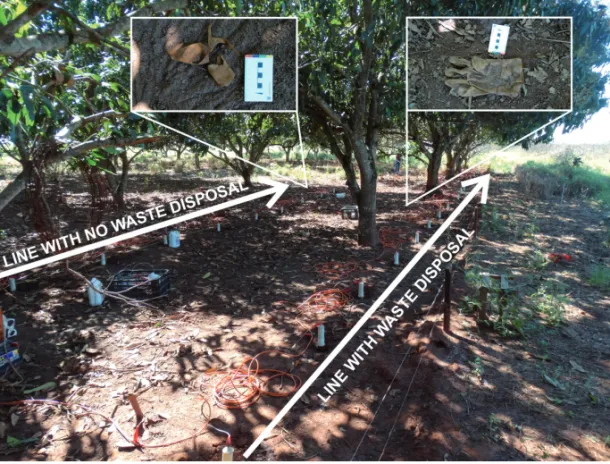
In field, were conducted 9 parallel lines of electrical tomog-raphy with 30 meters each, with an 3,75 meters of space between lines, positioned alternately along and between the lines of crop. To compare the results and have a better understanding of the sit-uation, it was conducted a reference line, located in a northern area that did not receive the waste (Fig. 1). During the acquisi-tion, some residual crust waste over the ground was found even when the environmental report claimed for the total removal of all the crust waste (Fig. 2).
The acquisition of the geophysical data by the equipment Terrameter LS made by ABEM with cable and electrodes happened in July, 2015. Is was used the Schlumberger array and spacing between electrodes of 1,5 m. The instrument was programmed to use a maximum electric current of 100 mA and a minimum of 50 mA, the current was sent during 1 second, the delay time was 0,4 second and the readings occurred in 2 intervals of 100 mil-liseconds each.
The data acquired in field was processed and labored on in order to obtain as a result a bidimensional electrical profile and tridimensional models to resistivity (Ω.m) and chargeabil-ity (mV/V) parameters. The measures in field were processed by the software Res2dinv (version 3.53) and resulted in an inver-sion model in terms of distance × depth, and an interpolation with a logarithmic scale. The profiles have presented the con-trast from the measures after the interpolation in a color scale, where the cold colors are attributed to low values and hot col-ors to the high ones. This software determines automatically a bidimensional model of the subsurface from resistivity or charge-ability obtained in the electrical tomography survey (Griffiths & Barker, 1993).
The numeric values of the bidimensional inversion profile from each section (field line) were reunited in a spreadsheet that contains the position of the values along the lines (variablex), the space between the lines (variabley), the depth (variable z)
and the resistivity or chargeability values (variable R). Each point from the 3D modeling is transformed in a block with condi-tional dimensions from a statistic criterion by the minimum curve method in the software Oasis Montaj, Geosolft plataform (version 6.4). The works of Moreira et al. (2013, 2015, 2016); Vieira et al. (2016); and Cortˆez et al. (2016) describe in detail the elabora-tion of 3D visualizaelabora-tion models used in this work.
DISCUSSION AND RESULTS
The analysis of the inversion models indicates an evident value variation between the alternate lines, with respect to the reference line positioned at north. The odd lines (1, 3, 5, 7, and 9) presented great contrast. On the other hand, the even lines (2, 4, 6, and 8) presented similar patterns to the reference line. In the field, the tomography lines 1, 3, 5, 7 and 9 were placed under the line of mango trees, where the waste disposal occurred, and the tomog-raphy lines, 2, 4, 6 and 8 were placed parallel and between the line of the mango tress (with no disposal waste) (Fig. 2).
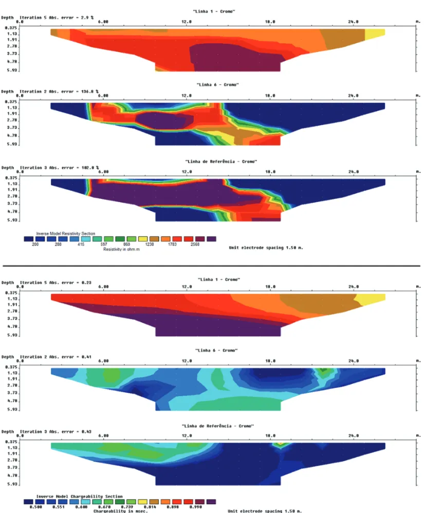
The resistivity and chargeability measures were processed in a joint way, on logarithmic scale to highlight the extremes values. The same scale were applied to all resistivity profiles and the values ranged from 200 Ω.m to 2568 Ω.m, and the same procedure to chargeability showed values that ranged from 0,5 mV/V to 0,99 mV/V (Fig. 3).
In terms of resistivity, it was expected that the profiles of the lines that received the waste had lower values than the nat-ural pattern of the area (200-288Ω.m) due to the presence of chromium, however, the parameter was not enough to detect the contaminant. The high resistivity (1238-1783Ω.m) may be linked to a higher presence of roots or the presence of Fe in the oxidized form.
Comparing the geophysical lines in the contaminated area with the reference one, it indicates that the limit of natural charge-ability for the area is 0,67 mV/V, in that way, values above this limit indicate a contamination by residual chromium.
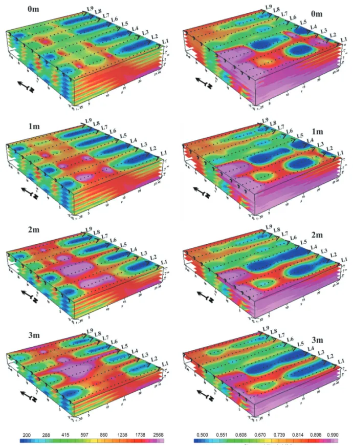
The 3D modeling through the interpolation of the 2D sections allowed the generation of depth visualization models at several levels (Fig. 4). In processing, the color scale was the same as the 2D inversion values.
The depth maps allow a reaffirmation of the disparity between the areas below the trees where the waste were added to the ar-eas between the trees that were not impacted, demonstrating that the presence of residues modified the natural physical parame-ters of the site.
In the beginning of the first lines, the chargeability shows a value of 0,99 mV/V, which can indicates that the area are
Figure 2 – Detailed acquisition of geophysical data and residual crust.
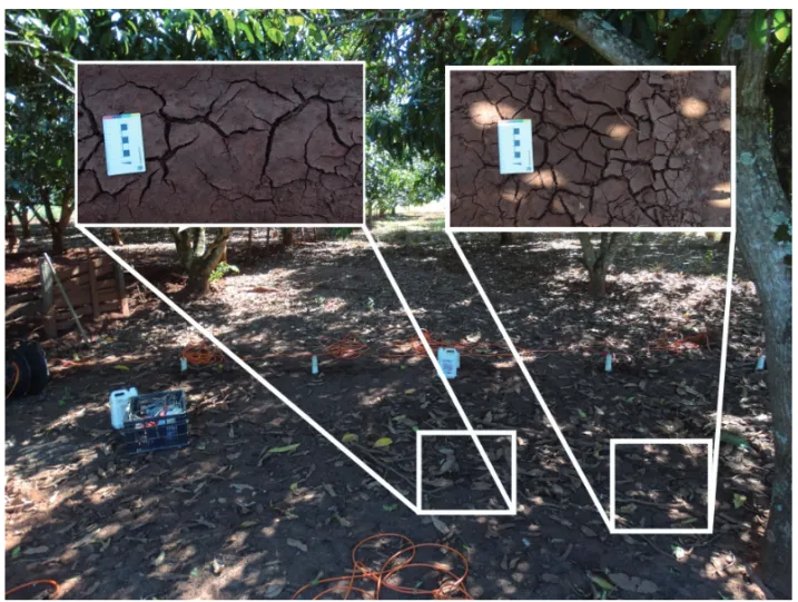
contaminated. In those areas, there is a depression of the local relief that can accumulate water during the rainy seasons and be-come saturated with water for long periods, indicating the pres-ence of mud cracks only in this particular area (Fig. 5).
In addition to characterizing the area, environmental contami-nation studies should understand how the contaminants, once in-serted in the environment, present themselves. What determines the expression of the contamination depends on the chemical form or speciation of the element, since it affects the distribu-tion, mobility and toxicity. Speciation can be understood as the form that an element in the environment presents itself: free, com-plexed, adsorbed or precipitated. Many agents control speciation, the most relevant ones are pH and Eh (Rai et al., 1989; Plant et al., 1996; Kotas & Stasicka, 2000).
Therefore, the physical-chemical conditions in the mud cracks allow a period of chemical reduction, a process favor-able to the persistence of Cr (III) on soil. The accumulation and persistence of chromium in this area can be attributed to the oc-currence of soils with their origins in igneous basaltic extrusion, with high levels of clay’s minerals and a characteristic red col-oration from the oxidation of magnetite. This soil are rich in this type of oxides and is a possible important agent to fix the chromium in the superficial levels of the soil.
To understand what happened to the chromium in the rest of the area, it is important to know that the reduction of Mn e Fe
oxides is a common process that is used to convert Cr (III) to Cr (VI) (Bartllet & James, 1979; USEPA, 1994). This last one is highly mobile and soluble in water, in this way, in rainy periods; the pluvial waters can lixiviate the element completely. Probably this is the main process occurring in the study area.
In this way, the geophysical survey indicates that the phys-ical and chemphys-ical conditions allowed the process of lixiviation occurred in almost the entire contaminated area, however, a small area still have the presence of chromium in soil, but it is not in a form that is available for the mango trees. It is possible that the chromium will be found in an oxides or hydroxides form, com-plexed in the soil.
CONCLUSION
The results of the joint application of electrical current methods in an area with amounts of chromium from an irregular disposal of leather crust, showed a contrast in the physical properties of the area. Among the processes, that involves a concentration or dis-persion of chromium in the environment, the lixiviation and com-plexation processes probably were crucial to the initial mobility and posterior retention of the chromium in the first soils layers.
The chromium on soil has its origins in the lixiviation of the leather crust that were disposed in windrows along the mango trees. The interconnection between the geophysical data and
i i
“main” — 2018/3/20 — 19:47 — page 314 — #6
i i
314
APPLIED GEOPHYSICS ON A SOIL CONTAMINATED SITE BY CHROMIUM OF A TANNERY IN MOTUCA (SP, BRAZIL)Figure 4 – 3D models for the resistivity and chargeability for several depths.
the record of the contaminated area, allows the definition of a geophysical signature to the compound in soil that contains chromium, differently from the natural electrical pattern.
Chargeability data are essential to identify the residual con-tamination, once only by this method it is possible to set out the situation of the contaminated site. For metals such as chromium, it is possible that occur the phenomenon of electronic polariza-tion, with accumulation of charges under the presence of an
elec-trical current. Even with the high concentration of metallic min-erals such as iron in the soil, only when the minmin-erals were com-plexed to the chromium ions, forming oxides, it was possible for the chargeability measures to obtain a higher value that distin-guishes itself from the rest of the area.
Among the alternatives of remediation of contaminated sites by chromium, the natural attenuation is a very common one. The diversity of elements that are capable of reduce the Cr (VI) to Cr
i i
“main” — 2018/3/20 — 19:47 — page 316 — #8
i i
316
APPLIED GEOPHYSICS ON A SOIL CONTAMINATED SITE BY CHROMIUM OF A TANNERY IN MOTUCA (SP, BRAZIL)Figure 5 – Presence of mud cracks in field.
(III) in normal environmental conditions and posteriorly precipi-tate the element, gives this technic an important viability on re-ducing the toxicity and even the concentration of the element.
In this way, with the soil analyses that had a reduction in the total chromium concentration throughout the years; the geophys-ical response that indicates a restrict area of residual contamina-tion in an area with less than 100 square meters; the assumpcontamina-tion that the chromium occur in his less toxic speciation (Cr (III)), it is possible to conclude that the natural attenuation phenomenon occurred well in the study area.
REFERENCES
ABDI – ASSOCIAC¸˜AO BRASILEIRA DE DESENVOLVIMENTO INDUS-TRIAL. 2011. Relat´orio de Acompanhamento Setorial: Ind´ustria de Couro. Bras´ılia, DF, Brazil, 44 pp.
BARTLETT RJ & JAMES BR. 1979. Behavior of Chromium in Soils. Environmental Quality, 8(1): 31–35.
BELL FG. 1998. Environmental Geology. Great Britain: Blackwell Sci-ence. 594 pp.
BIELICKA A, BOJANOWOSKA I & WISNIEWSKI A. 2005. Two Faces of
Chromium – Pollutant and Bioelement. Polish Journal of Environmen-tal Studies, 14(1): 5–10.
CETESB – COMPANHIA DE TECNOLOGIA E SANEAMENTOAMBIENTAL DO ESTADO DE S˜AO PAULO. 2001. Manual de Gerenciamento de ´Areas Contaminadas. S˜ao Paulo: CETESB.
CETESB – COMPANHIA DE TECNOLOGIA E SANEAMENTOAMBIENTAL DO ESTADO DE S˜AO PAULO. 2005. Curtumes. S˜ao Paulo: CETESB. 76 pp. Available on:<http://www.cetesb.sp.gov.br>. Access on: Septem-ber 22, 2015.
CETESB – COMPANHIA DE TECNOLOGIA E SANEAMENTOAMBIENTAL DO ESTADO DE S˜AO PAULO. 2013. Disposic¸˜ao de aparas de couro no Assentamento Monte Alegre. S˜ao Paulo: CETESB.
CETESB – COMPANHIA DE TECNOLOGIA E SANEAMENTOAMBIENTAL DO ESTADO DE S˜AO PAULO. 2014. Valores orientadores para Solos e ´Aguas Subterrˆaneas para o Estado de S˜ao Paulo. S˜ao Paulo.
C ˆORTES ARP, MOREIRA CA, VELOSO DIK, VIEIRA LB & BERGONZONI FA. 2016. Geoelectrical prospecting for a copper-sulfide mineralization in the Camaqu˜a sedimentary basin, Southern Brazil. Geof´ısica Interna-cional, 55(3): 107–117.
CUNHA LFJ da & SHIRAIWA S. 2010. Aplicac¸˜ao do M´etodo Eletro-magn´etico Indutivo na Investigac¸˜ao da Pluma de Contaminac¸˜ao da ´Agua
Subterrˆanea por Res´ıduos de Cromo de Curtume. Brazilian Journal of Gephysics, 29(1): 127–134.
ELIS VR & ZUQUETTE LV. 2001. Aplicac¸˜ao integrada de m´etodos geoel´etricos em ´areas de disposic¸˜ao de res´ıduos industriais: cidade de Franca, Brasil. Geotecnia, 92: 47–69.
FACHIN SJ da S, HUBBER F, SHIRAIWA S, BORGES WR & MIGLIORINI RB. 2006. Aplicac¸˜ao de M´etodos Geof´ısicos para Identificar ´areas Con-taminadas por Res´ıduos de um Curtume. Brazilian Journal of Gephysics, 24(1): 129–138.
GRIFFITHS DH & BARKER RD. 1993. Two-dimensional resistivity imag-ing and modelimag-ing in areas of complex geology. Journal of Applied Geo-physics, 29: 211–226.
KOTAS J & STASICKA Z. 2000. Chromium occurrence in the environ-ment and methods of its speciation. Environenviron-mental Pollution, 107(3): 263–283.
KN ¨ODEL K, LANGE G & VOIGT HJ. 2007. Enviromental Geology: Hand-book of fields methods and case studies. Hannover Federal Institute for Geosciences and Natural Resources. Ed. Springer. 1357 pp.
MOREIRA MV & TEIXEIRA RC. 2003. Estado da arte tecnol´ogico em processamento de couro: revis˜ao bibliogr´afica no ˆambito internacional. Porto Alegre: Centro Nacional de Tecnologias Limpas. 242 pp. MOREIRA CA, BRAGA ACO, GODOY LH & SARDINHA DS. 2013. Rela-tionship between age of waste and natural electric potential generation in Sanitary Landfill. Geof´ısica Internacional, 52(4): 375–383.
MOREIRA CA, MUNHOZ T, CAVALLARI F & HELENE LPI. 2015. Electrical resisitivity to detect zones of biogas accumulation in a landfill. Geof´ısica Internacional, 54(4): 353–362.
MOREIRA CA, LAPOLA MM & CARRARA A. 2016. Comparative ana-lyzes among electrical resistivity tomography arrays in the characteri-zation of flow structure in free aquifer. Geof´ısica Internacional, 55(2): 119–129.
NUNES LPM & LUIZ JG. 2006. Caracterizac¸˜ao Geoel´etrica de ´Area de Curtume Localizada no Distrito Industrial de Icoaraci, Bel´em-Par´a. Brazilian Journal of Geophysics, 24(4): 467–481.
PAPP JF. 1994. Chromium Life Cycle Study. U.S. Geological Survey, Bureau of Mines, Information Circular 9411, 91 pp.
PLANT JA, BALDOCK JW & SMITH B. 1996. The role of geochemistry in environmental and epidemiological studies in developing countries: a review. In: FUGE JD & McCALL GJHG. Environmental Geochemistry and Health, Geological Society Publication, 113: 7–22.
RAI D, EARY LE & ZACHARA JM. 1989. Environmental Chemistry of Chromium. The Science of the Total Environment. Elsevier Science – Publishers, Amsterdam, 86: 15–23.
SANKARAM S, RANGARAJAN R, KUMAR KK, RAO SS & HUMBARDE SV. 2009. Geophysical and Tracer Studies to Detect Subsurface Chromium Contamination and Suitable Site for Waste Disposal in Ra-nipet, Vellore District, Tamil Nadu, India. Environmental Earth Science, Berlin, 60(1): 757–764, jun. 2009.
TELFORD WMW, GEDART LP & SHERIFF RE. 1990. Applied Geo-physics. London, UK: Cambridge University Press – 2nd ed., 792 pp. USEPA – U.S. Environmental Protection Agency. 1994. Natural Attenua-tion of Hexavalent Chromium in Groundwater and Soils. Oklahoma. USEPA – U.S. Environmental Protection Agency. 2010. Toxicological review of hexavalent chromium. Washington.
VIEIRA LB, MOREIRA CA, C ˆORTES ARP & LUVIZOTTO GL. 2016. Geo-physical modeling of the manganese deposit for Induced Polarization method in Itapira (Brazil). Geof´ısica Internacional, 55(2): 107–117. YE T-F, GONG Y-L & MENG X-L. 2011. Experimental Study on Chromium Contaminated Sites by Geophysical Methods. Elsevier: Procedia Earth and Planetary Science, Beijing, 2: 223–228.
Recebido em 18 janeiro, 2016 / Aceito em 13 fevereiro, 2017 Received on January 18, 2016 / Accepted on February 13, 2017
