Edited by
Jaime Aníbal, Ana Gomes, Isabel Mendes & Delminda Moura
RIA FORMOSA
Challenges of a coastal lagoon
in a changing environment
2. Backbarrier shores along the Ria Formosa lagoon
A. Rita Carrasco & Ana Matias
Centre for Marine and Environmental Research (CIMA), University of Algarve, Campus de
Gambelas, 8005-139 Faro, Portugal
[email protected]; [email protected]
2.1. Low-energy environments and backbarrier shores: where can we find them?
Low energy beaches are located in sheltered and fetch-limited environments. The fetch, also called the fetch length, is the uninterrupted distance over the sea surface for which the wind can blow without a change in direction and affects the growth of wind-waves. Fetch-limited beaches are found in estuaries and bays (e.g. Chesapeake Bay, USA), behind ocean barriers (e.g. Pamlico Sound, USA), adjacent to inlets (e.g. Tapora Bank, New Zealand), deltas (e.g. Menderes River, Turkey), eroding thermokarst (e.g. Yensei Bay, Russia), and glacial outwash fans (e.g. Canal Baker, Chile; Cooper et al., 2007). In the case of barrier island systems, the back of barrier islands facing the lagoon environments i.e., backbarrier shores are fetch-limited environments. A barrier is an elongated ridge that is composed predominantly of unconsolidated sand and/or gravel and protect the adjacent mainland from open-water processes (Figure 2.1). From the sea to the mainland, the barriers are generally composed of the shoreface, dune and backbarrier environments, and they are separated alongshore by tidal inlets (Figure 2.1). Barrier islands are dynamic systems, constantly on the move, migrating under the influence of waves, tides, currents, storms, and changing mean sea levels. The backbarrier is a narrow, elongated, intertidal landform that is located on the lagoon or estuary side of the barrier island and can take the form of sandy beaches, tidal flats or salt marshes (Figure 2.1). Backbarrier beaches tend to be morphodynamically reflective (according to the classification of Wright & Short, 1984), with steep narrow foreshores that have smaller seasonal variations than open ocean beaches. The tidal flat is bound to the foreshore and might end in a salt marsh fringe. Salt marshes are among the most productive ecosystems on earth. Backbarriers provide critical ecosystem services to coastal populations (see Box 2.1.).
Figure 2.1.
2.2. Ria Formosa backbarriers
The Ria Formosa is a highly dynamic multi-inlet barrier island system located in the Algarve region, Southern Portugal (Figure 2.3). The Ria Formosa backbarrier forms a continuum system, ranging from linear sand bodies morphologically indistinguishable from transgressive open-ocean barriers (Pilkey et al., 2009) to extensive fans of tidal marshes, intercepted by very small tidal channels.
The entire Ria Formosa lagoon covers an area of 8.4×10⁷m2(Andrade, 1990), and is characterised by i)
extensive salt marsh areas, with a dense distribution of shallow meanders composed of silt and fine sand (Bettencourt, 1994); ii) large sand flats, partially flooded and reworked during spring tides (Pilkey et al., 1989); and iii) a complex network of natural and partially-dredged channels, which get narrower and shallower towards the upper regions of the system (Andrade et al., 1998). The lagoon is a very shallow area with a maximum depth of 2 m (below mean sea level, Figure 2.3), supporting substantial
sedimentary and morphological variability (Andrade, 1990).
Box 2.1. Backbarrier ecology: the importance of salt marshes
Salt marshes are among the most productive ecosystems on earth and have great ecological value, namely in flood risk management and erosion, nutrient regeneration, primary
production, habitat for wildlife species, and as shoreline stabilizer (e.g. Costanza et al., 1997; Caçador et al., 2016). Salt marshes ecological role have been formally recognised by its inclusion in the Water Framework Directive.
Over time, salt marshes accumulate organic material, forming a dense layer called peat. Salt marshes and tidal flats also play an important role in capturing carbon (especially Zostera
noltii tidal plains in Figure 2.2), by absorbing in biomass the gaseous carbon – carbon
dioxide. Carbon fixation in the soil is highly beneficial to slow global warming and other harmful effects of high carbon content in the atmosphere. When a marsh is destroyed, usually because of human impact, and the organisms die, the carbon that had been absorbed and stored in the biome will be released back into the air as carbon dioxide.
Figure 2.2.
View of the ecological marsh succession, from the low marsh dominated by Spartina maritima and the tidal flat dominated by Zostera noltii (in the Culatra Island backbarrier; photo by A. Rita Carrasco, 2017).
The barrier system comprises five islands and two peninsulas, separated by six tidal inlets. The barrier system is extremely dynamic which has been related with tidal inlet evolution (Pacheco et al., 2010; Vila-Concejo et al., 2006), shoreline evolution (Garcia et al., 2002), longshore drift (Ciavola et al., 1997),
overwash processes (Matias et al., 2008), dune formation (Gomes et al., 1994), backbarrier processes (Carrasco et al., 2011) and artificial nourishment actions (Dias et al., 2003).
The backbarrier system receives minimal ocean swell and is dependent on local winds for wave
development. Most backbarrier shores face fetch distances shorter than 2 km (see example Figure 2.4A), and therefore they are exposed to small waves and are characterised by low, narrow sandy beaches (Figure 2.4B), alternating with portions of tidal flats, salt marshes, and washover plains (flat areas
generated by large overwash events and breaches). Occasionally, intertidal bars are attached to the beach foreshore (sand banks in Figure 2.4C), suggesting that there is sediment exchange between the low-tide terrace and the foreshore (see beach segmentation in Figure 2.4D).
Evolutionary trends calculated from historic aerial photograph analysis show that the extremities of the system (both peninsulas) are immature (recent and under construction), while the rest of the system is characterised by a predominance of mature backbarriers (Carrasco et al., 2008). The overall evolutionary trend of the Ria Formosa backbarrier indicates a shrinking of the lagoon (coastal squeeze) due to the landward displacement of the backbarrier together with a decrease in the extent of the backbarrier coastline (Carrasco et al., 2008).
From the view point of conservation, the Ria Formosa lagoon was designated a Natural Reserve in 1978, a Natural Park in 1987, and is now part of the Natura 2000 network, with the aim of achieving a rational and sustainable exploitation of its resources (see Box 2.2.). The system hosts high faunal diversity, with
national importance as a nest-building zone and international relevance for bird migration. Moreover, it is considered a worldwide noteworthy wetland area, protected by the RAMSAR and BERNA conventions. Ria Formosa resources protection and exploitation involves a complex web of cultural habits, economic constraints, and legal and political perceptions, amongst other issues, making management a difficult task.
Figure 2.3.
(A) Ria Formosa barrier system (coordinates WGS84; elevation referred mean sea level). (B) View of the two main environments in the backbarrier shores, namely sandy beaches and salt marshes (photos by A. Rita Carrasco, 2017).
Figure 2.4.
(A) Example of fetch distribution behind Praia de Faro;
(B) view of the foreshore (dune and beach face, photos by A. Rita Carrasco, 2008); (C) view of an intertidal bar attached to the tidal flat (sand bank);
(D) example of a typical profile segmentation in sandy backshores at Ancão Peninsula backbarrier composed of dune, beach-face, tidal flat and sand bank.
2.3. Morphological Evolution
Backbarrier beach profile characteristics include a narrow foreshore (~35 m wide, slope ≅ 0.07), with reflective swash zones and a low gradient terrace acting as a wave energy filter (Figure 2.4 (B) and (C)). The tidal flat has a gentle slope (slope ≅ 0.01; Figure 2.4 (C) and (D)), ending in a small flat parallel sand bank (30 m of length, slope ≅ 0.06). The tidal flat is mainly sandy (mean grain size, dmean = 0.3 mm) with 9 % of mud. The beach face and sand bank are coarser (dmean of 0.9 mm and 0.4 mm, respectively).
Site-specific factors related to geomorphologic settings and hydrodynamics, for example the proximity to a tidal inlet, shape beach evolution. Backbarrier beaches face almost the same forcing mechanisms as
Box 2.2. The importance of the Ria Formosa backbarrier and lagoon
to the local economy
Besides being an important element of the overall coastal system, the backbarrier and lagoon serve as the main ‘feeder’ of the local marine economy, with economic activities such as aquaculture, fishing, shipping, sand mining and tourism, coexisting in a fragile and often-competing combination. The shellfish and clams harvest, which takes place in most of the backbarrier shores and inside the lagoon, is the most important addition to the local economy as they are a high-value crop, representing more than 90% of the national clam harvest. It is estimated that about 5000 people depend on the clam industry, out of the about 100,000 people total population around the lagoon (Cristina et al., 2006). Urban development in the Ria Formosa backbarrier is concentrated in 5 villages, namely Praia de Faro, Farol, Hangares, Culatra e Armona (Figure 2.5).
Figure 2.5.
Example human development and activities on the backbarrier of Culatra Island (photo by A. Rita Carrasco, 2006).
oceanic beaches, but at a relatively lower magnitude (Figure 2.6). For instance, wind and wave-setup are much reduced in backbarrier beaches, when compared with wind and wave-setup acting on oceanic beaches; wave-runup is almost null in backbarrier beaches (Figure 2.6).
Figure 2.6.
Comparison between forcing mechanism action in oceanic beaches and backbarrier beaches.
Medium time-scale analysis (days to years) demonstrates that volumetric beach response is slow and continuous (less than tens of cubic meters of change between months), similar to other sheltered mesotidal beaches described in literature (Carrasco et al., 2012; Figure 2.7A and B). Short-term dataset analysis (minutes to days) confirmed the limited sediment transport, with daily rates of change below 0.05 m3/m, occurring mostly on the beach face (see example Figure 2.7B). The beach face and the
nearshore (sand bank) act as independent morphological sub-systems. Contrary to most oceanic beaches, backbarrier beaches lack cyclic changes, with a slow response to hydrodynamic forcing (Figure 2.8).
Figure 2.7.
(A) Volumetric variations at the backshore, beach face, tidal flat and sand bank zones, over two years of analysis in a backbarrier portion of Ancão Peninsula (datasets from BERNA project, financed by Fundação para Ciência e Tecnologia under reference
POCTI/CTA/45431/2002); (B) sand accumulation in the backshore driven by wind, and embryonic berm formation as result of wind-induced waves (associated to relative higher energetic conditions or storm conditions; photos by A. Rita Carrasco, June 2006 and February 2008, respectively).
2.3.1. Wind, waves and tidal currents on the backbarrier beaches of Ria Formosa
Since most backbarriers of the Ria Formosa are nearby- or under the direct influence of tidal channels and inlets, the tidal currents are the principal source of energy for sediments mobilization and transport (Carrasco et al., 2011). Average local tidal currents are within the order of 0.3 m/s, with maximum
velocities of 0.5 m/s; these values are closely dependent on the distance to inlets. Backbarrier beaches are not very reactive to wind intensity fluctuations and the sand availability is an important factor for beach modulation. Figure 2.8 shows the lack of correlation between beach morphological changes and wind variability (Figure 2.8; Carrasco et al., 2012). During relatively high-energy events (e.g. winter), mudflats can even prevent most waves from reaching the barriers and reduce the energy of the few waves that reach the shore (as suggested by Lewis et al., 2007); other factors as wakes present minor influence to
morphology (see Box 2.3.). Wakes are small waves generated by the passage of boats on channels.
Figure 2.8.
Example of beach volume variations at a backbarrier beach exposed to N-NE winds, in comparison with changes in the local wind patterns (wind direction and wind intensity); dashed line represents the averaged beach volume during three years of analysis.
Box 2.3. Do you know that…
The generation, propagation, attenuation and forces related to boat generated wake waves are being recently investigated due to increasing concerns regarding their impact on backbarriers beaches and salt marshes. Boat wakes have been shown to have erosive effects on shorelines (e.g. Ellis et al., 2002), scour the bottom of the shoreface, and temporarily decrease of water clarity (Kurennoy et al., 2011). In addition, boat wake impacts include
vegetative damage and disruption of faunal communities. They are most destructive in shallow and narrow waterways because wake energy does not have the opportunity to dissipate over distance. Numerous waves within these ranges were documented in the Praia de Faro backbarrier and all around the lagoon, especially inside the main navigational channels.
2.3.2. The role of human interventions on the backbarrier shores
Permanent or seasonal human modifications, such as urban development or marine exploitation, are conspicuous on many backbarrier shores in the world (Nordstrom et al., 1996). Many human-altered beaches around the world bear little resemblance to their potential state under natural conditions, and many others were created where none would occur naturally. There are numerous types of impacts, and several have profound effects for many years, for instance, natural sediment deposits in backbarrier marshes, tidal creeks or other lagoon environments, behind barrier islands and spits, have been used in the past for beach nourishment. Dredging operations have removed sediments inside the lagoons, with consequences to the sediment supply of backbarrier shores. This occurred during the last years in the Ancão Peninsula backbarrier, where a dramatic morphological change is noticeable between 1947 and ~2007 (Figure 2.9). The main reasons for the observed changes are artificial operations to manage the Ancão Channel. The dredging of Ancão Channel after 1976 and the relocation of Ancão Inlet in 1996, lead to a shoreline advance (i.e. backbarrier shoreline displacement towards the lagoon), development of a detached morphology (sand bank, Figure 2.9), while the channel reduced its width and its margins enlarged (development of a tidal flat). Human activities left a strong local imprint and consequent inheritance, instilling morphological changes that were neither erased nor counteracted by the cumulative backbarrier evolution trends (Figure 2.9).
2.3.3. The role of sea-level rise in the sedimentary processes of backbarriers
Although the overall understanding of how barrier islands respond to climate change continues to improve, very few details are known about how the backbarrier shores will evolve to rising sea levels (Carrasco et al., 2016), including the behaviour of Ria Formosa under sea-level rise. Literature predicts that under such conditions, backbarrier shores will lose sub-areal extent and the sea-level rise will gradually change the hypsometry of the barrier, transforming supratidal areas into intertidal and open-water environments. Inside the lagoons, the inundation of the tidal flats and salt marshes will probably increase, leading to the conversion of sub-areal areas on backbarrier to open waters (Carrasco et al., 2016).
Backbarriers composed of salt marshes, appear to be less vulnerable to rising sea level because marsh can
Figure 2.9.
Aerial views of long-term evolution of the Ancão Peninsula backbarrier (aerial photos from CIMA/UAlg database). Inside the red square, from 1947 to 2007, a sandy platform developed, that differentiated trough time into three sandy morphologies: foreshore, tidal flat and sand bank.
accommodate vertical accretion up to a certain rate (Carrasco et al., 2016; see Box 2.4.), although results are not conclusive.
On the frontier with ocean, sea-level rise may cause changes in inlets geometry or in tidal forcings (Smith, 2001), affecting the baseline level of sediment transport arising to backbarrier shores. It is still, however, difficult to make accurate predictions of coastal change due the non-linearity of sedimentary processes, and the uncertainty on their ‘downscaling’. Even if detailed descriptions exist of the responses of barrier chains and inlets to sea-level rise, as well as various attempts to systematize the foreseen impacts, a deficiency remains in the conceptualization of expected morphological changes.
Box 2.4. The role of seagrass in the long-term sedimentary
processes of backbarrier salt marshes
Seagrass meadows (see Figure 2.10) can stabilise sediments and help to facilitate surface elevation accretion (Fonseca, 1996). When seagrass occupies the entire water column, current velocities are reduced, and sediments tend to accumulate.
The impact of seagrasses is remarkably strong, with average sediment accumulation differences up to 30 mm per year between seagrass and unvegetated areas (e.g. Potouroglou et al., 2017). The capacity of seagrasses for balancing the deposition of
suspended sediment and resuspension is highly dependent on the development stage and health of the plants, as well as local hydrological conditions.
Figure 2.10.
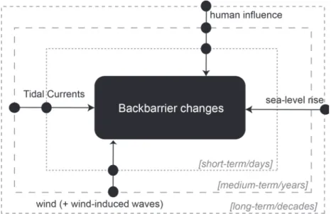
Figure 2.11 summarizes the main drivers and respective timescales of interaction, acting on the backbarrier shores of Ria Formosa. Tidal currents, wind and wind-induced waves, rising sea level and human interventions, are the main natural and anthropogenic forcing mechanisms that drive changes at backbarrier shores (Figure 2.11). Each driving factor operates at different timescales; for instance, human interventions affects the short- to long-term evolution of backbarrier shores, whilst the tidal currents, but at the long-term their effect can be counteracted.
2.4. Coastal management and ecosystem-based approach
Although the Ria Formosa lagoon is protected under the designation of a Natural Park, so far there are no policies devoted specifically to manage its backbarrier shores. Backbarriers are of local great ecological importance (see Box 2.1), and their management requires integrated coastal studies and management strategies linking not only biodiversity and conservation, but also natural evolution and human usage. Because the exploitation of the Ria Formosa backbarrier and lagoon resources have a relevant
contribution to the local economy (see Box 2.2), scientific improvements should look up to the balance between the coastal morphological dynamics and the ecological functions that are hosted by these environments, in an attempt to maintain ecosystem services.
Based on the tendencies highlighted on the previous sections, we propose a simple ecosystem-based management scheme settled in a two-pillar structure, that includes (1) the morphology (type and evolution), and (2) the function (number of functions; e.g. ecological, economic, recreation, amongst others). In Figure 2.12, backbarrier functioning is defined by a flux of sediment (and energy) from the morphology type to the function/service provided. This flux is controlled by internal processes, as small-to long-term behaviours that regulates the morphology type and evolution, and by the environmental characteristics that determines its functioning or provided service (Figure 2.12). External controls account with human interventions that governs the morphological evolutions, and direct uses linked to the provided service. This scheme considers the existence of a dynamic equilibrium crossing the morphology and the function/service, controlled by internal and external processes (Figure 2.12). The scheme
illustrates what we consider the most important factors affecting the management of backbarrier shores. It traduces the idea that despite the lower variability of backbarrier shores, and the uncertainty about its future evolution under external environmental changes (as sea-level rise), and equilibrium between backbarrier morphology and related functions is needed to ensure the ecosystem future maintenance.
Figure 2.11.
Summary of the main drivers and respective timescales acting on the backbarrier shores of Ria Formosa.
Figure 2.12.
Ecosystem-based scheme for the backbarrier shores along the Ria Formosa lagoon.
Acknowledgements
This is a contribution for the EVREST project (PTDC/MAR-EST/1031/2014). A. R. Carrasco was supported by the grant SFRH/BPD/88485/2012.
References
Andrade, C., Cunha, J. M. & Paulino, J., 1998. Geochemical signature of extreme marine flooding in the Boca do Rio lowland (Algarve, Portugal). Proceedings of V Congresso Nacional de Geologia. IGN, SGP, Lisboa, p. C-51/C-54.
Carrasco, A. R., Ferreira, O., Davidson, M. A., Matias, A. & Dias, J. A., 2008. An evolutionary categorisation model for backbarrier environments. Marine Geology 251:156-166.
Carrasco, A. R., Ferreira, Ó., Matias, A. & Freire, P., 2012. Natural and human-induced coastal dynamics at a back-barrier beach. Geomorphology 159-160:30-36.
Carrasco, A. R., Ferreira, Ó., Matias, A., Pacheco, A. & Freire, P., 2011. Short-term sediment transport at a backbarrier beach. Journal of Coastal Research 27:1076-1084.
Carrasco, A. R., Ferreira, Ó. & Roelvink, D., 2016. Coastal lagoons and rising sea level: A review. Earth-Science
Reviews 154:356-368.
Ciavola, P., Taborda, R., Ferreira, Ó. & Dias, J. A., 1997. Field measurements of longshore sand transport and control processes on a steep meso-tidal beach in Portugal. Journal of Coastal Research 13:1119-1129.
Cooper, J.A.G., Pilkey, O. H.& Lewis, D. A., 2007. Islands behind islands: an unappreciated coastal landform category. Journal of Coastal Research SI50:907-911.
Dias, J. A., Ferreira, Ó., Matias, A., Vila-Concejo, A. & Sá-Pires, C., 2003. Evaluation of soft protection techniques in barrier islands by monitoring programs: case studies from Ria Formosa (Algarve-Portugal). Journal of Coastal Research SI35:117-131.
Ellis, J. Y., Sherman, D. J., Bauer, B. O. & Hart, J., 2002. Assessing the impact of an organic restoration structure on boat wake energy, Journal of Coastal Research SI36:256-265.
Garcia, T., Ferreira, Ó., Matias, A. & Dias, J. A., 2002. Recent Evolution of Culatra Island (Algarve – Portugal), In: EUROCOAST (Ed.), Littoral 2002, The Changing Coast. EUCC-Porto - Portugal, pp. 289-294.
Kurennoy, D., Parnell, K. E. & Soomere, T., 2011. Fast-ferry generated waves in Southwest Tallinn Bay. Journal
of Coastal Research SI64:165-169.
Lewis, D. A., Cooper, J. A .G., Pilkey, O. H. & Short, A. D., 2007. Fetch-limited barrier islands of Spencer Gulf, South Australia, Journal of Coastal Research SI50:912-916.
Matias, A., Ferreira, Ó., Vila-Concejo, A., Garcia, T. & Dias, J. A., 2008. Classification of washover dynamics in barrier islands. Geomorphology 97:655-674.
Nordstrom, K. F., Jackson, N. L., Allen, J. R. & Sherman, D. J., 1996. Wave and current processes and beach changes on a microtidal lagoonal beach at Fire Island, New York, USA In K.F. Nordstrom and C.T. Roman (eds.) Estuarine Shores. London: John Wiley & Sons, Ldt. pp. 213-232.
Pacheco, A., Ferreira, Ó., Williams, J. J., Garel, E., Vila-Concejo, A. & Dias, J. A., 2010. Hydrodynamics and equilibrium of a multiple-inlet system. Marine Geology 274:32-42.
Pilkey, O. H., Cooper, J. A. G. & Lewis, D. A., 2009. Global distribution and geomorphology of fetch-limited barrier islands. Journal of Coastal Research 25:819-837.
Potouroglou, M., Bull, J. C., Krauss, K. W., Kennedy, H. A., Fusi, M., Daffonchio, D., Mangora, M. M., Githaiga, M. N., Diele, K. & Huxham, M., 2017. Measuring the role of seagrasses in regulating sediment surface elevation. Scientific Reports 7:11917.
Smith, N. P., 2001. Seasonal-scale transport patterns in a multi-inlet coastal lagoon. Estuarine Coastal and
Shelf Science 52:15-28.
Vila-Concejo, A., Matias, A., Pacheco, A., Ferreira, Ó. & Dias, J. A., 2006. Quantification of inlet-hazards in barrier island systems. An example from the Ria Formosa (Portugal). Continental Shelf Research 26:1045-1060.
Wright, L. & Short, A., 1984. Morphodynamic variability of surf zones and beaches: a synthesis. Marine