U
NIVERSIDADE DO
A
LGARVE
Morphodynamic Evolution of
Fetch-limited Beaches
Ana Rita Carrasco
Doutoramento em Geociências, especialidade em Dinâmica Litoral
U
NIVERSIDADE DO
A
LGARVE
Morphodynamic Evolution of
Fetch-limited Beaches
Ana Rita Carrasco
Doutoramento em Geociências, especialidade em Dinâmica Litoral
Tese orientada por: Doutor Óscar Manuel Fernandes Cerveira Ferreira (Universidade do Algarve)
Doutora Paula Maria dos Santos Freire
(Laboratório Nacional de Engenharia Civil)
Nome: Ana Rita Zarcos Carrasco
Faculdade: Faculdade de Ciências e Tecnologia
Universidade: Universidade do Algarve
Orientadores: Prof. Doutor Óscar Ferreira e Doutora Paula Freire
Título da Tese: Evolução Morfodinâmica de Praias de Fetch-limitado
R
ESUMOA presente tese analisa a evolução morfodinâmica de uma praia lagunar de fetch-limitado, localizada no sistema de ilhas barreira da Ria Formosa. Para tal, consideraram-se três escalas temporais de análiconsideraram-se: curto-termo, médio-termo e longo-termo. Pretendeu-se determinar: (a) quais os mecanismos forçadores que regem o transporte sedimentar na praia; (b) qual a evolução morfológica da praia de médio a longo-termo, e (c) qual a importância das intervenções humana na dinâmica morfológica da praia.
A curto-termo termo (ao longo de um ciclo de mare), o transporte sedimentar foi localmente determinado com recurso à aplicação de traçadores fluorescentes, através da quantificação das variações morfológicas e taxas de transporte. A evolução da praia a médio e longo-termo (entre meses e de anos a décadas) foi obtida através da análise de levantamentos topográficos e análise de fotografia aérea vertical. No final, propõe-se uma breve metodologia destinada a avaliar a suscetibilidade a inundação de ambientes costeiros de fetch-limitado. A metodologia proposta identifica zonas com perigosidade a inundações, quantifica o risco associado e equaciona as medidas de gestão local mais apropriadas.
Palavras-chave: praia lagunar, fetch limitado, escalas temporais, transporte
Name: Ana Rita Zarcos Carrasco
Faculty: Faculdade de Ciências e Tecnologia
University: Universidade do Algarve
Supervisors: Prof. Dr. Óscar Ferreira and Dr. Paula Freire
Title: Morphodynamic Evolution of Fetch-limited Beaches
A
BSTRACTThis thesis examines the morphodynamic evolution of a fetch-limited backbarrier beach located in the Ria Formosa barrier island system. Three different scales of analysis were ascribed: a short-term scale, a medium-term scale, and a long-term scale. Main issues addressed were: (a) the factors governing sediment transport under very limited-fetch conditions; (b) the morphological evolution at medium to long-term, and (c) the role of human interventions in beach morphology.
At short-term (over the tidal cycle) sediment transport patterns were locally determined by employing fluorescent tracer techniques, and quantifying morphologic variations and transport rates. The medium- to long-term evolution (between months and from years to decades) was set based in topographic surveys and aerial photograph analysis. Finally, a general framework was developed for flood hazard assessment at fetch-limited coastal environments. This framework embraces the hazard zones identification, risk analysis and the associated most reasonable management options.
R
ESUMOA
LARGADOAs praias de fetch-limitado distribuem-se ao longo de estuários, baías, zonas lagunares, deltas, lagos, entre outros ambientes, caracterizados por ondas de curto período (2-3 s) e com alturas na ordem dos centímetros (Hs = 0.10 m a 1.0 m), em
função das condições de ‘fetch’ local (comprimento de água sobre o qual um determinado vento sopra). Embora estes ambientes costeiros sejam dos mais densamente povoados, os estudos convencionais sobre praias arenosas tendem a concentrar-se em praias oceânicas, o que têm resultado num pior entendimento acerca da sua evolução e morfodinâmica. Recentemente, surgiu a necessidade se de desenvolver e prosseguir com estudos dedicados à colheita de dados morfológicos e hidrodinâmicos neste tipo de ambientes. Apesar dos seus recursos naturais poderem não se apresentar imediatamente atrativos, as praias de fetch-limitado têm elevado valor pela sua singularidade ecológica, participando ativamente na dinâmica sedimentar local.
A presente tese analisa a evolução morfodinâmica de uma praia lagunar de fetch-limitado, localizada no sistema de ilhas barreira da Ria Formosa (sul de Portugal), ao longo de diferentes escalas temporais. O sistema de ilhas barreira da Ria Formosa foi designado como Reserva Natural em 1978, Parque Natural em 1987, e nos últimos anos como Rede Natura 2000. É caracterizado por uma elevada diversidade faunística e têm importância nacional e internacional como local de nidificação e migração de aves. A investigação científica costeira neste sistema de ilhas barreira tem sido até então dedicada principalmente à dinâmica litoral da margem oceânica, descurando a dinâmica
dependente dos ventos locais e do fetch disponível para geração de onda, normalmente na ordem dos poucos quilómetros de comprimento. Nestas condições, as alturas de ondas de não tempestade são da ordem de poucas dezenas de centímetros (Hs = 0.1 -
0.2 m).
Em particular, esta tese foca a sua atenção na margem lagunar da Península do Ancão (extremo Oeste do sistema de ilhas barreira da Ria Formosa), onde as condições de fetch são espacialmente as mais reduzidas ao longo de toda o sistema (fetch < 2 km); à praia é atribuída a condição de ‘fetch muito limitado’. A praia é particularmente estreita (~100 m), de baixa elevação vertical (~2 m acima do nível médio do mar) e comporta quatro setores morfológicos principais: a alta praia, a face de praia, o terraço de maré e um banco arenoso (no final do perfil transversal). A parte superior da praia contacta com um extenso campo dunar que se prolonga até à praia oceânica. A parte inferior da praia contacta diretamente com o canal do Ancão. O comportamento morfodinâmico da praia é, na sua globalidade, aqui descrito ao longo de três escalas temporais distintas: a curto-termo (variação da praia à escala diária), a médio-termo (variação da praia de meses a anos), e a longo-termo (variação da praia de anos a décadas). Como objetivos específicos pretendeu-se (a) determinar quais os mecanismos forçadores que regem o transporte sedimentar na praia; (b) caracterizar a evolução da praia entre meses e de anos a décadas, e (c) avaliar a importância de intervenções humanas na dinâmica morfológica da praia.
Os fatores que regem o transporte sedimentar (análise de curto-termo) foram determinados com recurso à aplicação de traçadores fluorescentes. Realizaram-se duas campanhas de campo, em 2006 e 2008, durante dois períodos de não tempestade e em
condições de marés vivas. As duas campanhas contemplaram por si próprias, diferentes escalas temporais de amostragem: a primeira ao longo de apenas um ciclo de maré, e a segunda contemplou um ciclo completo entre marés vivas e marés mortas. Os traçadores fluorescentes foram colocados durante a baixa-mar, na face de praia e no banco arenoso (final do perfil topográfico, junto ao canal do Ancão). O regime de correntes foi caracterizado com recurso a equipamento específico para medição de correntes (dois correntómetros eletromagnéticos e um Aquadopp profiler). Nas duas campanhas recolheram-se amostras sedimentares e procedeu-se à execução de levantamentos topográficos no início e no final do período de monitorização. Definiu-se a variabilidade morfologia típica ao longo de um ciclo de maré (0.03 m2 m-1), o transporte sedimentar diário (máximo 0.03 m3 d-1), bem como o regime de ventos (máximo 12 m s-1), as velocidades de correntes de maré (máximo 0.5 m s-1) e os respetivos limiares de corrente para despoletar transporte de fundo (ucr; ucr= 0.008 m s-1
para a face de praia e ucr = 0.005 m s-1 para o banco arenoso). As ondas geradas pelo
vento foram caracterizadas visualmente (recurso a régua graduada) durante a primeira campanha, enquanto, durante a segunda campanha foram caracterizadas através de modelação numérica (Hs < 0.1 m e Tmean ~1.0 s). As técnicas de aplicação de traçadores
fluorescentes foram ainda discutidas no contexto das taxas de transporte obtidas. De acordo com os padrões observados, efetuou-se a distinção entre transporte por advecção e dispersão que caracteriza este tipo de ambiente. Os resultados obtidos demonstraram que para praias de fetch muito limitado, as técnicas de aplicação de traçadores fluorescentes devem ser conduzidas com prudência, e requerem a realização de testes prévios para determinar a quantidade ideal de traçador a utilizar e o respetivo tempo de adequação à camada superficial de transporte.
(entre 2005 e 2008). Efetuaram-se levantamentos topográficos com periodicidade mensal e trimestral em 10 perfis transversais à área de estudo. Comparou-se a variabilidade volumétrica total da praia e a variabilidade volumétrica de cada setor morfológico, com as condições de vento dominantes para no mesmo período de análise; o vento foi tido em conta como indicador das condições de agitação local. Avaliou-se ainda a dominância de variações transversais vs. longilitorais ao longo da área de estudo. Os resultados obtidos na análise de médio-termo corroboram os resultados obtidos com as duas campanhas de curto-termo, ou seja, variabilidade volumétrica reduzida. Para o período de análise (2005 a 2008) a variação volumétrica na alta praia e face de praia foi de 0.18 m3 m-1 e 4.88 m3 m-1, respetivamente, enquanto a variação máxima volumétrica no terraço de maré e no banco arenoso foi 4.50 m3 m-1 e -3.45 m3 m-1, respetivamente. Os quatro sectores morfológicos verificaram a mesma tendência de evolução mensal, alternando entre períodos de acreção e erosão sedimentar, o que sugere relativa homogeneidade na praia; os sectores morfológicos não apresentaram trocas sedimentares significativas entre si. A análise volumétrica interanual revelou que as zonas com maior mobilidade sedimentar se localizam no terraço de maré (no banco de areia e perto do canal do Ancão), nos limites entre a face de praia e o terraço de maré e entre o banco arenoso e o terraço de maré. Não foi observada sazonalidade significativa nos resultados obtidos. Na verdade, a praia não se demonstrou imediatamente reativa à maioria das condições de vento observadas, exibindo uma evolução lenta e contínua numa escala temporal de meses a anos. Durante o período de análise dominaram ventos de W-NW com intensidade média na ordem dos ~4 m s-1 (máximo de 17 m s-1 para o período de análise).
Observou-se interligação entre a evolução morfológica da praia a médio e longo-termo. Mesmo operando a escalas de tempo diferentes, as duas análises foram complementares na medida em que tendências observadas na primeira ajudaram na compreensão da segunda. A evolução de longo-termo (de anos a décadas) foi obtida através da análise de fotografia aérea vertical entre 1947 e 2007. A área de estudo revelou uma tendência média de variação de linha de costa de 0.05 m ano-1, com avanço significativo do campo dunar na direção do canal do Ancão (para terra). Morfologicamente, as principais alterações tiveram lugar no canal do Ancão e nas suas imediações. Foram distinguidos quatro períodos distintos de alteração: de 1947 a 1976, de 1976 a 2001, de 2001 a 2005 e de 2005 a 2007.
Os resultados obtidos demonstraram que a praia lagunar esteve sujeita a diferentes mecanismos forçadores nos últimos 60 anos, revelando duas respostas morfológicas distintas: uma resposta natural da praia, condicionada apenas pelos mecanismos forçadores naturais (vento, onda e corrente de maré) e uma outra resposta “modificada”, como resultado de intervenções humanas. As intervenções humanas decorreram essencialmente entre 1996 e 2001 e consistiram em dragagens ao longo do canal do Ancão e a recolocação da barra do Ancão para uma posição poente. As dragagens motivaram a transposição do eixo do canal do Ancão e a criação do banco arenoso, com consequente progressão da linha de costa para o canal. A recolocação da barra do Ancão estabeleceu um novo regime de correntes locais.
As intervenções efetuadas incutiram alterações morfológicas na praia, bastante diferentes das observadas, em períodos sem intervenção humana (ex. entre 2005 e 2008 com a análise de médio-termo). A previsão de evolução da praia a longo-termo mostrou-se uma tarefa dificultada devido à complexidade dos processos que nela decorrem e devido à inerente fragilidade do sistema, i.e., fraca capacidade para retornar
evolução natural da margem lagunar. Na verdade, os resultados demonstraram que as praias de fetch muito restricto, como é o caso da margem lagunar da Península do Ancão, podem permanecer relativamente inalteradas por um longo período, devido às condições de baixa energia. Neste cenário, a própria praia revela um ‘atraso’ na resposta morfológica aos mecanismos forçadores dominantes. Estas observações são de extrema importância, não só para a compreensão global a longo-termo do comportamento deste tipo de praias, como também podem ser bastante úteis a nível de gestão costeira local.
Ainda no âmbito da análise de longo-termo, a presente tese incluiu uma proposta metodológica para aferir o potencial de inundação em ambientes costeiros de fetch-limitado. A metodologia é dedicada apenas a zonas costeiras com risco de inundação forçado pela variabilidade na maré astronómica, sobrelevação meteorológica e contribuição fluvial (ex. zonas estuarinas, lagunas costeiras, deltas, etc). Possui como principal vantagem metodológica o facto de se basear na combinação de duas abordagens distintas: inundações costeiras e inundações fluviais. Abrange a identificação de zonas com perigosidade, o mapeamento de risco de inundação e consideração acerca de medidas de gestão local ambientalmente mais sustentáveis. Na determinação do potencial de inundação esboça dois tipos de variáveis: as que afetam os níveis de água (maré astronómica, sobrelevação meteorológica da maré, subida do nível médio e contribuição fluvial) e as que afetam os impactos de inundação (ocupação humana, geomorfologia e ecologia). A metodologia desenvolve-se ao longo de três etapas principais: (1) a identificação das fontes de perigosidade (determinação de níveis de inundação para os períodos de retorno de 1, 10 e 100 anos), (2) o mapeamento da inundação para diferentes cenários temporais (1, 10 e 100 anos), e (3) a análise de risco
e proposta de medidas de gestão costeira face aos cenários de inundação obtidos. A análise de risco a inundações é discutida no contexto ecológico e humano: o risco ecológico relaciona-se com o potencial de inundação áreas de dunas, paisagens protegidas e habitats, enquanto o risco humano relaciona-se com o potencial inundação de áreas com ocupação humana.
As medidas de gestão costeira propostas assentam maioritariamente sobre uma perspetiva de ‘adaptação’ às condições impostas pela inundação (proposta de um Guia Estratégico de Adaptação). A opção de ‘adaptação’ é considerada a mais adequada do ponto de vista financeiro, diminuindo o impacto económico, social e urbano de intervenções drásticas (por exemplo obras de proteção costeira). Esta estratégia equaciona a manutenção e modificação de usos em zonas de risco de inundação. A maior parte dos usos propostos são usos de ‘valor acrescentado’, contribuindo para uma utilização sustentável das zonas costeiras, incluindo o reforço do valor ecológico e fortalecimento das atividades económicas, ao mesmo tempo que os riscos potenciais de inundação são minimizados. A estratégia proposta ajuda os gestores costeiros: (a) a identificar as zonas de risco elevado e moderado; (b) a implementar um processo orientado e flexível na adaptação de usos em ambientes costeiros de fetch-limitado; e (c) a considerar as medidas de gestão costeira não só para enfrentar a ‘prioridade de conservação de áreas em risco’, mas também para aumentar o seu potencial económico.
Esta metodologia foi aplicada à margem lagunar da Península do Ancão. Os cenários de inundação obtidos tiveram como base o ano de 2010. Os níveis de inundação prevista para 1, 10 e 100 anos de retorno períodos obtidos foram de 2.08 m, 2.45 m e 3.11 m MSL (nível médio do mar), respetivamente. Metodologicamente os níveis de inundação podem revelar alguma incerteza relacionada com erros na aplicação de distribuições probabilística aos níveis de maré e às próprias projeções de subida do
validação dos níveis obtidos. Os níveis de inundação obtidos foram projetados sobre Modelos Digitais de Elevação (espaçamento de 0.5 m), obtidos com base em levantamento LIDAR (Light Detection And Ranging) de Novembro de 2009 (erro vertical e horizontal de 5-10 cm). Para o caso de estudo em questão, os impactos mais significativos das inundações em ecologia estão relacionados com a interrupção temporária de local e espécies animais que povoam a zona de duna subaérea (principalmente na parte oriental da península). Os impactos das inundações em áreas de ocupação humana fazem-se sentir sobretudo em residências, acessos a residências e passadiços. Especificamente, para este caso de estudo, a adaptação para usos de ‘valor acrescentado’ e a correta gestão dos usos existentes é rentável do ponto de vista económico e social, contribuindo para o aproveitamento global e sustentável de toda a ilha barreira.
É importante realçar que os resultados obtidos nesta tese são uma importante contribuição para o conhecimento científico sobre a evolução morfodinâmica de praias de fetch-limitado. No entanto, ainda subsistem algumas questões relativas aos intervalos de variação morfológica neste tipo de ambientes. Depois da análise às praias de fetch muito limitado (fetch < 2 km, menor energia de onda), a investigação deve futuramente seguir para condições mais energéticas (fetch > 10 km). Deverá tentar estabelecer-se uma escala de variação morfológica, em função de diferentes comprimentos de fetch e consoante os principais mecanismos forçadores. Em futuros tópicos de investigação, e em margens lagunares, deverá ainda ser caracterizada a relação existente entre variabilidade morfológica e fatores ecológicos locais (ex. abundância de algas e diversidade de espécies animais no terraço de maré e face de praia).
A
CKNOWLEDGEMENTSDoing this thesis was a very long journey. I could write it as an amazing fairy tale, full with peculiar characters and its hilarious places, full of magic, dragons and gnomes, and all of those pleasant details that are part of a fantastic history. I could hear myself as an old storyteller talking about dates, places, and memories. Memories of fascinating battles in dark woods, or in dangerous seas that I was able to cross because I was not alone but surrounded with the bravest of the army’s. This work could never be done without you all who encouraged and supported me.
I would like to express my sincere gratitude to my supervisors, Dr. Óscar Ferreira and Dr. Paula Freire, for their strong guidance and unwavering support. My unique experience during this journey gave me two people to count on for insight and advice. Their knowledge, comprehension and friendship made this thesis possible. Óscar suggested that I take a step back and look at the bigger picture. Paula usually recommended getting to the essence of the problem and focusing on the specifics. I now realize that such combination provided me with a strong foundation, not only for doing science, but to face world. I acknowledge the frequent science discussions that I kept with Óscar over these years. I am certain that we both proved that describing coastal processes in fetch limited is not an easy task. I am also truly grateful to Dr. Ana Matias for her invaluable insights during results discussion, always teaching me to explore different perspectives.
(past and present): Tiago Garcia, Ana Vila-Concejo, André Pacheco, Ana Matias, Isabel Mendes, Francisca Rosa, Margarida Ramires, Júlio Cunha, Pedro Almeida, Mara Nunes, Carlos Loureiro, Erwan Garel, Selman Gabriel, and Simon Connor. I would like give special thanks to Ana Matias, Isabel, and Francisca for showing a genuine interest in my work and encouraging me to finish it.
To my friends, I will always be grateful: Ana Luísa, Frutinha, Catarina Sequeira, JSO, Ken, Hugo, Joni, Pipinha, Silvia, Catarina Santos, Tiagilha, Fred, Liliana, Pedro Coelho, Celso, Baco, Pedrilha, Cristina, Bruno, Ana Sofia, Alexandra e Marisa, for reminding me that there is so much in this world to experience, so much more than science. A special thanks to João Janeiro and Joel for their friendship and the challenging ‘good mornings’ that had accompanied me trough every day of this journey.
Finally, I extend heartfelt gratitude to my parents João Carlos and Eugénia for believing in me and in everything I have chosen to do, and to my brother João Pedro for making me feel safe over all these years. Thanks to Hélio for being so genuine, for your support, love and your amazing smile.
INSTITUTIONAL AND FINANCIAL SUPPORT
The work was funded by:
Fundação para a Ciência e a Tecnologia, PhD grant reference SFRH/BD/37366/2007; and
Fundação para a Ciência e a Tecnologia, Research fellowship under the “IDEM – Inlet Dynamics Evolution and Management at the Ria Formosa” (contract nº POCI/MAR/56533/2004).
Data collection was funded by the following scientific projects:
“IDEM – Inlet Dynamics Evolution and Management at the Ria Formosa” from Fundação para a Ciência e a Tecnologia (contract nº POCI/MAR/56533/2004); and
“BERNA - Beach Evolution in Areas of Restricted Fetch: Experimental and Numerical Analysis” from Fundação para a Ciência e a Tecnologia (contract nº POCTI/CTA/45431/2002).
Other support:
Tide data was kindly supplied by Puertos del Estado, Ministerio do Fomento, Gobierno de España; and
Sociedade POLIS Litoral Ria Formosa SA provided technical reports and raw data regarding management uses at Ria Formosa barrier system.
C
ONTENTS
Resumo ... i Abstract ... iii Resumo alargado ... v Acknowledgements ... xvii Contents ... xxi List of Figures ... xxv List of Tables ... xxixCHAPTER 1.INTRODUCTION ... 1
1.1. Fetch-limited beaches: Why study them? ... 2 1.2. Fetch-limited beaches: What to study about them? ... 4 1.3. Thesis outline and contribution of authors ... 5
CHAPTER 2.REVIEW OF FETCH-LIMITED BEACHES ... 9
2.1. Low-energy and Fetch-limited beaches ... 10 2.2. Human modifications to fetch-limited environments: a brief overview of
dredging and nourishment ... 13 2.3. Research in barrier islands facing low-energy conditions ... 14 2.4. Ria Formosa backbarrier ... 16
CHAPTER 3.SHORT-TERM SEDIMENT TRANSPORT AT A BACKBARRIER BEACH... 19 Abstract ... 20 3.1. Introduction ... 21 3.2. Field site ... 23 3.3 Methods ... 24 3.3.1. Fluorescent Tracer data ... 24 3.3.2. Grain-size data ... 27 3.3.3. Morphological data ... 28 3.3.4. Driving mechanisms data ... 28 3.4. Results ... 31 3.4.1. Grain-size characteristics and tracer transport ... 31 3.4.2. Morphological variability ... 33 3.4.3. Driving mechanisms ... 34 3.5. Discussion ... 39 3.6. Conclusions ... 43
CHAPTER 4.SEDIMENT TRANSPORT MEASUREMENTS WITH TRACERS IN VERY LOW -ENERGY BEACHES ... 45
4.5. Discussion and Conclusions ... 60
CHAPTER 5.MORPHOLOGICAL CHANGES IN A BACKBARRIER ... 63
Abstract ... 64 5.1. Introduction ... 65 5.2. Field site ... 66 5.3. Methods ... 67 5.4. Results ... 69 5.5. Discussion and Conclusions ... 74
CHAPTER 6. NATURAL AND HUMAN-INDUCED COASTAL DYNAMICS AT A BACKBARRIER BEACH ... 79 Abstract ... 80 6.1. Introduction ... 81 6.2. Field site ... 83 6.2.1. Regional setting ... 83 6.2.2. Human activities ... 85 6.3. Methods ... 87 6.3.1. Large-scale data collection ... 88 6.3.2. Small-scale data collection ... 90 6.4. Results ... 93 6.4.1 Large-scale evolution and morphological changes ... 93 6.4.2. Small-scale evolution, wind, grain-size, and volumetric changes... 98 6.5. Discussion ... 103 6.5.1. Linking timescales ... 103 6.5.2. Beach inheritance and resource value ... 108 6.6. Conclusions ... 109
CHAPTER 7. FLOOD HAZARD ASSESSMENT AND MANAGEMENT AT FETCH-LIMITED COASTAL ENVIRONMENTS ... 111
Abstract ... 112 7.1. Introduction ... 113 7.2. Methodology ... 115 7.2.1. Flood assessment terminology ... 115 7.2.2. Framework variables ... 117 7.2.3. Development of the framework ... 118 7.2.3.1. Hazard sources ... 120 7.2.3.2. Flood hazard mapping ... 121 7.2.3.3. Risk analysis and management ... 122 7.2.4. Sites for application of the framework ... 127 7.3. Test case: Ancão backbarrier ... 128 7.3.1. General characteristics ... 128
7.3.2.1. Step1: hazard sources ... 133 7.3.2.2. Step2: flood hazard mapping ... 134 7.3.2.3. Step3: risk analysis and management ... 134 7.4. Applicability of the method ... 140 7.5. Conclusions: benefits of the proposed framework ... 143
CHAPTER 8.FINAL CONSIDERATIONS ... 145
8.1. General conclusions ... 146 8.2. Critical assessment ... 150 8.3. Future work ... 152
L
IST OF
F
IGURES
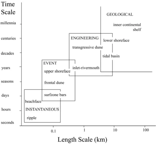
Figure 1.1. Definition of spatial and temporal scales involved in coastal evolution. Large-scale coastal landforms evolve over long timescales, whereas small-scale coastal features respond over short timesmall-scales [adapted from Cowell and Thom, 1994]. ... 5 Figure 3.1. Field site location, showing Ancão Peninsula backbarrier, and (inset) a
vertical aerial photograph (taken in 2007) with the surveyed profiles and a representative beach profile (M.H.W. = mean high water and M.L.W. = mean low water, based on field data) with instrument position (ECM = electromagnetic current meter, ADP = acoustic Doppler profiler); FT1 and FT2 (fluorescent tracers), deployed during fieldwork are also shown ... 25 Figure 3.2. Photographs of the field site: (a) fetch distribution on a vertical aerial
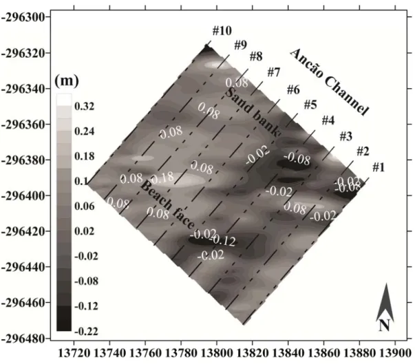
photograph from 2007; (b) view to NW of the narrow sandy foreshore (July 2007); (c) high shell content in muddy sediments on the tidal flat (October 2006); and (d) from offshore, Ancão tidal channel, offshore sand bank (with shore-normal depression) and tidal flat (January 2006) ... 26 Figure 3.3. Map of tracer concentration at (a) beach face, and (b) sand bank, 24 h after tracer release. Locations of injection points and FT mass centroids are shown (metric coordinates refereed to Portuguese Melriça Grid, datum 73) ... 33 Figure 3.4. Surface variations between surveys represented as a contour map of
isopachs. The numbers (#n) are the topographic profile number. Metric coordinates refer to the Portuguese Melriça Grid, datum 73 (referenced to mean sea level) ... 34 Figure 3.5. Driving mechanisms observed during fieldwork: (a) time-average wind
intensity and direction; (b) time-average current velocity at the beach face; and (c) time-average velocity at the sand sand bank. The dashed lines in (b) represent ECM data gaps due to equipment malfunction ... 36 Figure 3.6. Cross-shore velocity component for the first 10 min of data recorded by
the electromagnetic current meter (ECM; ~10 cm of water depth above the current meter) ... 37 Figure 3.7. Time-averaged shear velocity (u ) and critical shear velocity (* u ) cr
considering d10 (ucrd10) and d50 (ucrd50) at (a) beach face, and (b) sand bank
... 39 Figure 4.1. Field site location (a) at the Ancão Peninsula backbarrier (Ria Formosa
barrier system), overlapped by the scheme of cross-shore and alongshore components at the field site (b); EM corresponds to the position of the
Figure 4.2. Time-averaged currents at the sand bank; data recorded at the lower cell of the equipment (0.7 m above the sensor). Positive alongshore values mean flood, and negative values mean ebb; positive cross-shore values mean offshore (directed towards the Ancão tidal channel) and negative values mean onshore ... 54 Figure 4.3. Map of tracer concentration at the beach face. Locations of injection
points, tracer mass centroids, and number of tagged grains are shown (cross-shore and alongshore) ... 56 Figure 4.4. Map of tracer concentration at the sand bank. Locations of injection points, tracer mass centroids, and number of tagged grains are shown (cross-shore and alongshore) ... 57 Figure 4.5. Sediment transport variation during the field experiment: (a) daily Q and Qcumulative at the beach face; and (b) daily Q and Qcumulative at the sand bank ... 60 Figure 5.1. Field site location and aerial photograph with the location of the analyzed representative profiles (S1, S2 and S3) ... 68 Figure 5.2. Wind climate (average magnitude and direction); volume variability at
each beach sector, and correlation matrixes (volume and slope) between sectors. ... 70 Figure 5.3. Sediment distribution at the beach-face and sand spit between April 2006
and March 2008 ... 72 Figure 5.4. Profile envelope (maximum, minimum and average volume profile),
volume change at each profile during the analyzed period, and volume correlation matrix between profiles ... 73 Figure 6.1. (a) Field site location, showing Ancão Peninsula backbarrier; and (b) a
vertical aerial photograph (taken in 2007) showing the main beach morphologies, profile a, and profile j ... 84 Figure 6.2. Photographs of the field site: (a) view of the backshore (June 2006); (b)
sandy foreshore (December 2008); (c) high shell content in the tidal flat (October 2006); (d) Ancão tidal channel, sand bank (intercut by the secondary tidal channel), and tidal flat (January 2006); (e) view of aeolian sediment accumulation in the backshore (February 2008); and (f) other view of the sand bank (January 2007) ... 86 Figure 6.3. (a) Surveyed area and beach compartments: backshore, beach face, and
nearshore (tidal flat and sand bank). Secondary tidal channel is also shown. Mean elevation is referred to MSL; (b) profile i envelope and standard deviation for the period April 2005 to March 2008; (c)
Figure 6.4. (a) Ancão backbarrier shoreline evolution between 1947 and 2007; and (b) shoreline displacements between 1947 and 2007 at the study area (aerial photo from 2005) ... 96 Figure 6.5. Field site evolution between 1947 and 2007; beach profile evolution
between 1944 - 1945 and 2008 ... 97 Figure 6.6. (a) daily mean wind direction; and (b) daily and monthly wind maximum velocity ... 100 Figure 6.7. Grain size distribution (d50) at profile d ... 100
Figure 6.8. Volumetric variations at (a) backshore; (b) beach face; (c) tidal flat; (d) sand bank; and (e) overall area ... 101 Figure 6.9. Inter-annual elevation changes between 2005 and 2008. Positive elevation changes are expressed with brighter color tones; DEMs were reconstructed as triangular irregular networks in ArcGis 9.3 ... 102 Figure 6.10. Beach and nearshore displacements towards Ancão channel between 2005 and 2008 ... 104 Figure 7.1. Schematic methodology for the flood hazard assessment and management of fetch-limited coastal environments ... 119 Figure 7.2. Map of Ria Formosa barrier system showing the locations of the Ancão
Peninsula and Praia de Faro village (left), and aerial photograph of Praia de Faro village (right) ... 129 Figure 7.3. Land uses of Ancão Peninsula ... 132 Figure 7.4. Examples of inundation attained at: (a) Ancão backbarrier during the
equinoctial tide of October 2006 (with a maximum storm surge of 14 cm); (b) Praia de Faro bridge during the equinoctial tide of March 2010 (with a maximum storm surge of 58 cm; photograph courtesy of Elsa Caetano); (c) the eastern part of Ancão backbarrier during the equinoctial tide of September 2011 (with a maximum storm surge of 10 cm); and (d) the western part of Ancão backbarrier during the equinoctial tide of March 2010 (photograph courtesy of Elsa Caetano) ... 133 Figure 7.5. (a) Lognormal distribution fitting to annual maximum tide levels; and (b)
representative topographic profile at Ancão backbarrier showing the main morphological segments (backshore, beach face, and nearshore) and inundation levels. ... 135 Figure 7.6. Hazard map for Ancão Peninsula for flood zones < 1 yr return period
(constant flooded), 1 - 10 yr (frequently flooded), and 10 - 100 (infrequently flooded) (lain over a 2009 orthophoto) ... 136 Figure 7.7. Risk map for occupancy and ecology at Ancão Peninsula ... 137
L
IST OF
T
ABLES
Table 3.1. Grain size parameters. FT = fluorescent tracers, d50 = median, d10 = limit
of 10% o the finer population ... 32 Table 3.2. FT transport velocities and volumetric transport (Q). Ux is the velocity in
the longshore direction and Uy is the velocity in the cross-shore direction
... 32 Table 3.3. Time-averaged flow conditions during field experiments and thresholds for bedload transport (ucr) at each morphology. Negative longshore velocity means S-E (ebb) and negative cross-shore velocity means N-E (towards the Ancão tidal channel). ucrd10 and ucrd50 are determined for tagged
population ... 38 Table 4.1. Tide, wind, waves, and currents during the fieldwork experiment ... 58 Table 4.2. Observed rates of transport based on tracer displacement. ubf and usb
correspond to the daily mass centroids velocity at the beach face and sand bank, respectively (accounting for both cross-shore and the alongshore velocity components); negative values of u correspond to flood and onshore directed tracer displacements; Q represents the daily transport from centroid positions (accounting for Qx and Qy), Qx represents the daily
alongshore, and Qy represents the daily cross-shore transport; negative
values of Qy correspond to onshore tracer displacement, and negative
values of Qx correspond to tracer displacements towards flood. l is the
daily immersed cross-shore length of each morphology ... 59 Table 6.1. Medium- and long-term datasets ... 89 Table 6.2. Total RMS error associated with georeferenced aerial photographs (in
metres) ... 90 Table 6.3. Shoreline displacements between 1947 and 2007 (positive values indicate seaward or northeast displacement, i.e., towards the Ancão channel), backbarrier morphologies and related changes. ... 98 Table 6.4. Correlation coefficients between morphology volumes and wind
conditions (p < 0.05 when r > 0.39) ... 103 Table 7.1. Permitted uses in flooded areas, developed within the proposed framework
... 124 Table 7.2. Example of an Adaptation Strategy Guidance ... 126 Table 7.3. Morphological characterization of Ancão Peninsula backbarrier, and social context ... 131
C
HAPTER
1
1.1. Fetch-limited beaches: why study them?
Fetch-limited beaches are found in estuaries and bays (e.g., Chesapeake Bay, USA); behind ocean barriers (e.g., Pamlico Sound, USA); adjacent to inlets (e.g., Tapora Bank, New Zealand); deltas (e.g., Menderes River, Turkey); eroding thermokarst (e.g., Yensei Bay, Russia); and glacial outwash fans (e.g., Canal Baker, Chile), amongst other places (Cooper et al., 2007). Although these types of environments are often located near densely populated areas, conventional studies of sandy beaches have focused on high-energy environments (e.g., Wright and Short, 1984; Lippman and Holman, 1990), which resulted in a poor understanding of the evolution and morphodynamics of fetch-limited beaches. The term ‘fetch-fetch-limited’ does not appear in the geomorphological literature prior to the early 1990s, and even over the ensuing decade it is difficult to find more than one or two papers per year that refer to fetch-limited or fetch-restricted coasts (Cooper et al., 2007). These days, a simple search on Web of Knowledge (all databases, 1899-present) demonstrates the still low scientific profile of these types of shores, with only 143 results for ‘low-energy beaches’, 21 results for ‘fetch-limited beaches’, and 27 for ‘backbarrier beaches’ (checked on 12 December 2011). Data sets in fetch-limited environments are incredibly scarce at a worldwide level. Portuguese research on fetch-limited processes at present is fetch-limited to just two places: the Tagus estuary (e.g., Freire and Andrade, 1999; Oliveira et al., 2006; Freire et al., 2009), and the Ria Formosa Barrier system (Ancão Peninsula backbarrier; e.g., Ciavola et al., 1997a; Carrasco et al., 2009). The results presented herein are the most recent contribution to the study of fetch-limited environments in Portugal.
While oceanic beaches respond rapidly to changes in energy conditions, fetch-limited beaches adjust slowly to shifts in energy conditions (Jackson et al., 2002a). The
CHAPTER 1.INTRODUCTION
delay in morphological response may give rise to features that are not representative of dominant wave conditions, but are a remnant of other energetic wave conditions (Costas et al., 2005). The low capacity to return to a prior morphological stage (Eliot et al., 2006) is an environmental ‘weaknesses’, and often hinders local management decisions, since there are few studies about profile response for this type of beach that could help to predict changes (e.g., Nordstrom, 1980; Jackson and Nordstrom, 1992). It is essential to develop and proceed with studies, including collection of morphological and hydrodynamic datasets, and it is essential to generate data that accurately report coastal dynamics on these types of shore; that is the main concern of this thesis.
Fetch-limited shores have a different economic resource potential from ocean beaches because of differences in wave energy, nearshore water depth, water temperature, landform shape and surface characteristics, amongst others (Nordstrom, 1992). Although their resources may not be immediately appealing, they have value because of their uniqueness and because they are located close to population centres (namely backbarrier shorelines). Backbarrier beaches are important counterparts of barrier systems, actively participating in local coastal dynamics. Like other fetch-limited shores, they can create a large variety of habitats, including beach, marsh and tidal flat (e.g., Kraeuter and Fegley, 1994; Botton and Loveland, 2003), often with a higher ecological value and biodiversity than oceanic beaches. Their low perceived value often results in a loss of beach habitat as the shoreline is modified to accommodate human uses or shore-protection methods (Nordstrom, 1992). A better understanding of these shorelines is important from a coastal management perspective, as the pace of development increases along lower energy waters (Lewis et al., 2007).
1.2. Fetch-limited beaches: what to study about them?
Hitherto, research on low-energy beaches has repeatedly adopted the morphodynamic classifications and morphological models used to describe high-energy beaches. However, recent research has demonstrated that viewing low-energy beaches as scaled-down versions of high-energy beaches is unsatisfactory (e.g., Nordstrom, 1992; Carrasco et al., 2011a). Crucial questions about beach dynamics – namely, the type and the related time of beach response – are yet to be asked, let alone answered, in fetch-limited morphodynamics. There remains a lack of knowledge about sediment transport patterns at different timescales and their dependency on the main causative forcing mechanisms (e.g., wind, tide, currents, river influence, amongst others), as well as the magnitude of human impacts.
The main objective of this research was to determine the morphodynamic time-scaling variability of a backbarrier beach located in a multi-inlet barrier system (Ria Formosa barrier system, Portugal). It includes the characterisation of beach morphology and process controls, including wind (and wind-generated waves), and tidal currents on a fetch-limited shoreline located on the Ancão Peninsula backbarrier. Three different scales of analysis were ascribed: a short-term scale (daily variability), a medium-term scale (months to years), and a long-term scale (decadal shoreline variability), covering the timescale spectrum from “instantaneous” to “event” (sensu Cowell and Thom, 1994; see Figure 1.1).
Research issues addressed in this thesis include:
(1) Determination of the site-specific controls on short-term beach morphodynamics, including an analysis of waves, tide, wind data, and sediment transport through the
CHAPTER 1.INTRODUCTION
definition of the main net surface changes at a daily timescale and from spring to neap tide;
(2) Characterisation of beach dynamics at medium to long-term scale of analysis, including the evolution rates of the major beach morphologies and an evaluation of human impacts in the long-term evolution; and
(3) Definition of flood hazard in fetch limited coastal environments, definition of an Adaptation Strategy Guidance to face coastal flooding events, and dedicated to support management decisions in fetch-limited environments.
Figure 1.1. Definition of spatial and temporal scales involved in coastal evolution. Large-scale coastal landforms evolve over long timescales, whereas small-scale coastal features respond over short timescales [adapted from Cowell and Thom, 1994].
1.3. Thesis outline and contribution of authors
The main chapters of this thesis refer to submitted, in press or already published peer-reviewed international scientific papers. The advantage of presenting a thesis by articles is that each chapter can be read independently; however, this format has the disadvantage of repeating certain details (e.g., study area description). While it is acknowledged that this repetition may hinder the flow of the text, the format has been maintained to preserve the integrity of the original publications. Three additional chapters were also included to improve consistency (Introduction, Review of Fetch-limited Beaches and Final Considerations). The thesis comprises eight chapters:
A brief introduction is given in CHAPTER 1, offering a description of low-energy
environments and fetch-limited beaches in the context of morphodynamic research. This chapter introduces the research topic and shows why it is important to study it.
CHAPTER 2 illustrates the recent research undertaken in fetch-limited beaches.
Describes the study area, the Ria Formosa barrier system and, in particular, the Ancão Peninsula backbarrier.
CHAPTER 3 is reprinted from the Journal of Coastal Research (A.R. Carrasco, Ó.
Ferreira, A. Matias, A. Pacheco and P. Freire, 2011. Sediment transport at a
backbarrier beach, 27(6), 1076-1084). This chapter describes the factors governing
sediment transport under fair-weather conditions, during the one tidal cycle. A.R. Carrasco and Ó. Ferreira developed the ideas. A. Matias and P. Freire were crucial to for fieldwork execution. A. Pacheco assisted with current-data collection. A.R. Carrasco analysed data and wrote the paper with the help of all co-authors;
CHAPTER 1.INTRODUCTION
CHAPTER 4 is submitted to Earth Surface Processes and Landforms (A.R. Carrasco, Ó.
Ferreira, A. Matias, P. Freire, X. Bertin, and J. A. Dias. Sediment transport
measurements by tracer in very low-energy beaches). This chapter describes the
factors governing sediment transport under fair-weather conditions encompassing a spring- to neap-tide cycle. A.R. Carrasco and Ó. Ferreira developed the ideas. X. Bertin provided wave-climate data (using the Morsys 2D application). A.R. Carrasco analysed data and wrote the paper with the help of all co-authors;
CHAPTER 5 is reprinted from the Journal of Coastal Research (A.R. Carrasco, Ó.
Ferreira, P. Freire, and J.A Dias, 2009. Morphological changes in a low-energy
backbarrier, SI56, 173-177). This chapter provides a brief overview about the of beach
variability between months and from months to years. This was the first paper to be published and represented the first data analysis within the scope of the present thesis. A.R. Carrasco analysed data and wrote the paper with the help of all co-authors;
CHAPTER 6 is under review in Geomorphology (A.R. Carrasco, Ó. Ferreira, A. Matias,
P. Freire. Natural and human induced coastal dynamics in at a backbarrier beach). This chapter describes medium- (within years) to long- term (from years to decades) variability of the Ancão backbarrier. A.R. Carrasco analysed data and wrote the paper with the help of all co-authors. Ó. Ferreira and A. Matias provided many critical reviews of the manuscript;
CHAPTER 7 is submitted to Ocean & Coastal Management (A.R. Carrasco, Ó. Ferreira,
A. Matias, and P. Freire. Flood hazard assessment and management of fetch-limited
potential of inundation in fetch-limited coastal environments. A.R. Carrasco analysed data and wrote the paper with the help of all co-authors.
CHAPTER 8 presents the general conclusions, crossover between timescales of analysis
C
HAPTER
2
2.1. Low-energy and Fetch-limited beaches
Low energy beaches are located in sheltered and fetch-limited environments. Sheltered environments occur in the lee of islands, reefs, or submarine ridges (Hegge et al., 1996), being protected to varying degrees from higher energy (deep-water) ocean waves. Fetch-limited environments occur in lakes (e.g., Roy et al., 2001), bays (e.g., Goodfellow and Stephenson, 2005), estuaries (e.g., Jackson and Nordstrom, 1992; Jackson et al., 2002a), and lagoons (e.g., Jackson et al., 2002b; Carrasco et al., 2008). Low energy conditions are created in different settings through the sheltering effect of the adjacent topography (sheltered environments) or the short fetch (i.e., the length of water over which a given wind has blown). Fetch distances that limit wave size (fetch-limited environments; Cooper et al., 2007).
According to coastal classification, fetch-limited beaches, where beach prisms are smaller than open ocean beaches (Jackson, 1999), tend to be morphodynamically reflective (Wright and Short, 1984; Sherman et al., 1994). Fetch length ranges from narrow, shallow lagoons, where onshore winds can only generate significant wave heights less than 0.10 m on the foreshore (Nordstrom et al., 1996), to beaches in the lee of reefs, where significant wave height at breaking is up to 1.0 m (Hegge et al., 1996). Limited fetch conditions produce small, steep waves, sometimes erosive due to short wave periods (Battjes, 1974; Jackson et al., 2002a). Beach morphologies include narrow and planar foreshores (Nordstrom, 1980; Jackson and Nordstrom, 1992; Hegge et al., 1996) with little evidence of bar forms seaward of low still-water levels (Jackson et al., 2002b). Places with higher tidal range, relative to wave height, are characterized by a steep upper foreshore with a broad, flat low-tide terrace (Jackson et al., 2002a). Extreme dissipative conditions prevail on the low tide terrace (Jackson and Nordstrom, 1992).
CHAPTER 2.REVIEW OF FETCH-LIMITED BEACHES
Sand availability and wind conditions are important factors in the modulation of fetch-limited beaches (Anthony et al., 2006). In fact, wind may be the main source of energy for mobilizing and transport of beach sediments in those environments (Jackson, 1995). Waves are generally wind-generated, with low heights (usually < 0.2 m) and short periods (2.0 - 4.5 s), and with changes that lead to a relatively low-frequency beach response (Nordstrom, 1977; Nordstrom, 1992; Hegge et al., 1996; Masselink and Pattiartchi, 2001; Costas et al., 2005). Higher energetic conditions are achieved when the dominant wind blowing direction is coincident with larger fetch length. Besides wind-waves, currents are particularly important near channels, projecting headlands, and constrictions in bays, and they may be also the dominant agent of sediment transport (Nordstrom, 1992). In conjunction with the orientation of the shoreline to dominant winds and fetch, currents may determine the local dominance of cross-shore or longshore processes (Jackson et al., 2002a). Currents can both stir up and transport sediments, while waves enhance stirring (Brown and Davies, 2009). The relative importance of tides within fetch-limited systems is fundamentally through the lateral shifts in wave processes and propagation associated with tide-driven water-level changes; boat wakes could also have significant impact on such beaches (Nordstrom, 1992; Curtiss et al., 2009).
The relevance of these forcing processes in beach profile modulation has been discussed by several authors, who demonstrate the foreshore to be the most active part of profile (e.g., Jackson, 1995). Profile changes were mainly defined by sediment removal from the upper foreshore during high-energy events and subsequent deposition in the lower foreshore, whereas the tidal terrace is kept relatively stable (Jackson and Nordstrom, 1992). Only during storms waves are of a sufficient magnitude to promote
and are only episodically active (Nordstrom, 1980). According to Nordstrom (1992), the depth of mobilization on the upper foreshore is small, and the active beach may be only a thin veneer of unconsolidated material. Rates of change are thus low, and surveyed profiles at fetch-limited beaches generally reveal little change in morphology, either alongshore or cross-shore (Nordstrom, 1980). In contrast to most oceanic beaches, changes to fetch-limited beaches can remain for long periods, since they usually have very low recovery rates (Nordstrom, 1992).
On the upper foreshore, wrack lines are an important feature of low energy beaches, because fair weather wave conditions are insufficient to modify debris deposited during storm events (Jackson et al., 2002b). Wrack, including human litter, seagrass, leaves, and other organic material, shelters underlying sediment deposits, preventing resuspension and beach erosion from low-energy return flow. Wrack permits the accumulation of sediment, because sand usually filters through debris, but hinders the aeolian resuspension of sediment. Just as low wave energy facilitates wrack accumulation, low wave energy may be partially responsible for a lack of dune development. Algal mats on the seaward tidal flat work in a similar manner, reducing the sediment supply (covering loose sediments) and stabilising the platform (Lewis et al., 2007).
Previous studies (Ekwurzel, 1990 in Goodfellow and Stephenson, 2005; Jackson and Nordstrom, 1992; Hegge et al., 1996; Travers, 2007) noted differences between the typical Wright and Short (1984) model of ocean-barrier beach dynamics and fetch-limited beach dynamics. Modal conditions following a storm event may not be an immediate beach response to high energy event but a reaction of the system’s memory to previous events, because of the beach lagging behind causative forcing mechanisms.
CHAPTER 2.REVIEW OF FETCH-LIMITED BEACHES
resistance of the beach profile and on the magnitude of seasonal changes. Besides natural forcing factors, fetch-limited beaches are also subject to other factors acting at short-term scales, such as human interventions, which may leave long-term inheritance in profile shape.
The geomorphology and morphodynamics of sheltered, low-energy coastal settings has received less attention than open ocean coastlines. Research dedicated to low-energy environments, particularly concerning fetch-limited areas and backbarrier systems, is scarce (e.g., Jackson et al., 2002a; Carrasco et al., 2008; Pilkey et al., 2009). In contrast, studies on the morphology of open-ocean beaches and on the relevant forcing mechanisms are widely represented in the coastal literature. The findings of this study should contribute to a better understanding of the different timescales of change in a fetch-limited backbarrier subjected to very low-energy conditions.
2.2. Human modifications to fetch-limited environments: a brief overview of dredging and nourishment
Permanent or seasonal human modifications (e.g., occupation or marine exploitation) are conspicuous on nearly every fetch-limited shore in the world (Nordstrom and Roman, 1996). Many human-altered beaches bear little resemblance to their potential state under natural conditions, and many beaches are created where none would occur naturally (Nordstrom, 1992). There are numerous types of impacts, and many have profound effects for many years. For instance, sediment deposits in backbarrier marshes, tidal creeks, bays, estuaries, and lagoon environments behind barrier islands and spits have all been used in the past for beach fill. They are an attractive source because they are protected from ocean waves and are often close enough to the project
beach to allow direct transfer of the material by pipeline. This eliminates the need for separate transport and transfer operations (Nordstrom, 1992). However, backbarrier areas are highly important elements in the coastal ecosystem and are sensitive to disturbance and alteration by dredging. Dredging is mostly done in overwash deposits and relict flood-tidal shoals, which may be ecologically important because they often provide suitable substrate for marsh growth, creating a great variability of habitats (e.g., Kraeuter and Fegley, 1994; Botton and Loveland, 2003). On retreating barriers, backbarriers may comprise a reserve of sand that will be recycled into the active beach deposits as retreat progresses. Flood-tidal shoals at an active inlet may be suitable as borrowing sites because the material removed is likely to be replaced by ongoing inlet processes. However, dredging material from active flood-tidal shoals can adversely alter both the hydraulic conditions in the inlet and wave action on adjacent shores.
As with sediment dredging, beach nourishment can also produce negative effects. Beach nourishment can enhance shore protection, but can also contribute to a decrease in habitat suitability by creating higher berms and wider backshores than would occur under natural conditions (Jackson et al., 2010). Studies of human projects need to predict the above effects over a short time horizon, helping to minimize negative events. Knowledge about short- and long-term patterns of sediment transport in these environments will provide important insights into predicting profile response-type.
2.3. Research on barrier islands facing low-energy conditions
Lewis et al. (2007) identified nearly 7500 actively evolving fetch-limited barrier islands worldwide. More of these islands occur around Australia than any other country. These barrier islands exist in every state and along every coast. Though barrier islands along
CHAPTER 2.REVIEW OF FETCH-LIMITED BEACHES
open ocean shorelines are the focus of hundreds of studies because they are simultaneously highly dynamic features and subject to intense development pressures (e.g., Hayes, 1979; Stutz and Pilkey, 2002), few studies look exclusively at fetch-limited barrier islands (Lewis et al., 2007). To some extent, the focus on fetch-fetch-limited systems has been developed by Nordstrom and Jackson, who were mostly devoted to estuarine beach research (e.g., Nordstrom, 1977; Jackson et al., 2002a). Indeed, it is tempting to attribute the merit of research done on this topic to both workers, in particular the outstanding case studies presented in Nordstrom (1980), Jackson (1995) and, Jackson et al. (2002a). The latter, especially, provides an extensive description of low-energy shorelines in marine and estuarine environments. We should also not forget Nordstrom’s (1992) book, containing an overall picture of sediment dynamics in estuarine beaches, with an important spotlight on estuarine beach natural values.
Other references to barrier islands within low energy environments include Pizzuto (1986; Delaware Bay, USA); Tanner and Demirpolat (1988; describing ‘low energy beach ridges’ in Laguna Madre, USA); Lewis et al. (2005; Chesapeake Bay and Delaware Bay, USA); Andrade et al. (2004; describing ‘marsh areas’ in the Ria Formosa, Portugal); Cooper et al. (2007; with a collation of geomorphogical settings on low energy beaches of North America, the Pacific and Mozambique coast); Pilkey et al. (2009; presenting the global distribution and morphology of active fetch-limited barrier islands); and Carrasco et al. (2008; defining types of backbarrier evolution in the Ria Formosa, Portugal). More recently, there has been an effort to study not only fetch-limited barrier islands, but also other types of fetch-fetch-limited beaches. Indeed, there was a significant peak in the output of publications on fetch-limited environments in 2009. The most relevant in terms of beach morphodynamics were Silveira and Psuty (2009;
Dolphin and Green (2009; with a detailed account of short-term wave modification in Manakau Harbour, New Zealand); Freire et al. (2009; with simple wave-tide classification of fetch-limited beaches in the Tagus estuary and Ria Formosa); and Ashton et al. (2009; particularly interesting in its exploration of self-organization in the evolution of fetch-limited shorelines).
2.4. Ria Formosa backbarrier
The Ria Formosa is a highly dynamic multi-inlet barrier island system located in the Algarve region, Southern Portugal. These islands are true barrier islands in that they contain the six required elements needed to impose the distinction of ‘barrier island’ to a littoral sand body: (1) an unconsolidated, elongated body of sediment (typically sand), (2) backed and fronted by a body of water, (3) fronted by a shoreface, (4) bounded by inlets with tidal deltas, (5) sitting on a barrier platform, and (6) “protecting” a mainland shoreline (Oertel, 1985).
The origin of the Ria Formosa is not clear, and several geological hypotheses for the system’s genesis have been proposed (Dias, 1988; Pilkey et al., 1989; Bettencourt, 1994). Dias (1988) and Pilkey et al. (1989) followed the Hoyt (1967, in Pilkey et al., 1989) model, suggesting that the origin of the sand islands is related to changes in sea-level during and after the glacial period, i.e., the Ria’s Holocene evolution fits within the classical shoreface transgression model. As on other fetch-limited barrier islands, the Ria Formosa backbarrier forms a continuum, ranging from linear sand bodies morphologically indistinguishable from transgressive open-ocean barriers (Pilkey et al., 2009). The entire backbarrier covers an area of 8.4×10⁷ m2 (Andrade, 1990), being characterised by: i) extensive saltmarsh areas with a dense distribution of shallow
CHAPTER 2.REVIEW OF FETCH-LIMITED BEACHES
meanders composed of silt and fine sand (Bettencourt, 1994); ii) large sand flats partially flooded and reworked during spring tides (Pilkey et al., 1989); and iii) a complex network of natural and partially-dredged channels, which narrow and shoal in the upper regions of the system (Andrade et al., 1998; Salles, 2001).
The backbarrier receives minimal ocean swell and is dependent on local winds for wave development, being a typical fetch-limited environment. The main hydrodynamic controls and shoreline morphology differs over short distances due to differences in fetch length and wind exposure. Common characteristics include wave heights in the order of centimetres, and waves driven primarily by local winds and occasional high-energy events (i.e., storms and/or high tides). Unlike open-ocean islands, fair-weather waves exert almost no control on the islands, because the limited fetch prevents fair-weather wave heights from exceeding 0.1 m (see typical Hs values in Carrasco et al., 2011a). Even then, the wide mudflats prevent most waves from reaching the barriers and reduce the energy of the few waves that reach the shore (Lewis et al., 2007). Since most of the backbarriers are near tidal channels and some of them under the direct influence of inlets, the other main hydrodynamic control is the tidal current. At other locations in the system, dune overwashes are the main cause of morphological changes, leading to washover fans in the backbarrier (e.g., Barreta Island, Matias, 2006)
The Ria Formosa barrier system has been the focus of several PhD theses (e.g., Andrade, 1990; Bettencourt; 1994; Salles, 2001) and scientific papers (e.g., Ciavola et al., 1997a; Balouin et al., 2005; Garcia et al., 2010). Research interest in this barrier system has until now been devoted to inlet dynamics, overwash sedimentary dynamics (e.g., Vila-Concejo et al., 2004a; Matias et al., 2008, Pacheco et al., 2010), and beach profile dynamics (e.g., Almeida et al., 2010; Ferreira, 2011); a few publications were
Most studies were focused on the open ocean coast and only a few works describe sediment dynamics on the lagoon side (Andrade, 1990; Andrade et al., 2004; Carrasco et al., 2008). The dynamics of the lagoon (and backbarrier areas) is presently an important research topic. Besides being an important element of the overall coastal system, the lagoon serves as the main ‘feeder’ of the local economy. Indeed, several economic activities take place in the system (e.g., aquaculture, fishing, shipping, mining and tourism), carrying a fragile combination of different and often-competing economic activities (Dias, 1988). The lagoon is a very low-lying area with maximum depth of 2 m (below mean sea level), supporting great sedimentary and morphological variability (Andrade, 1990). It was designated as a Natural Reserve in 1978, a Natural Park in 1987, and is now part of the Natura 2000 network, with the aim of achieving a rational and sustainable exploitation of its resources. This system is characterized by high faunal diversity, has national importance as a nest-building zone and international relevance for bird migration. Moreover, it is considered a noteworthy wetland area worldwide, and is protected by the RAMSAR and BERNA conventions.
The overall backbarrier has an intrinsic natural/ecological susceptibility to natural hazard events. The process of managing resources involves a complex net of cultural norms, economic constraints, and legal and political perceptions, amongst other issues, making management a difficult task. The findings of this thesis provide a step forward in generating knowledge for local coastal management.
C
HAPTER
3
S
HORT
-
TERM
S
EDIMENT
T
RANSPORT
Abstract
This paper defines short-term (tidal cycle) sediment transport patterns at a backbarrier beach based on detailed field studies. Fieldwork was planned to record non-storm, spring tide conditions, that enable the definition of background sediment dynamics at the study area. The experiment was set at two beach morphologies: beach face and sand bank. Current meters were deployed at both sites. Fluorescent tracer techniques were applied to determine rates and direction of transport. Topographic surveys and sediment sampling were undertaken.
During the experiment, limited tracer displacement and small morphological changes occurred. The low magnitude changes are representative of predominant low-energy hydrodynamic conditions. Sediment transport was primarily longshore orientated and dependent on the velocity of tidal currents. Tidal currents had the potential for sediment transport only during a short period of the tidal cycle, and had higher velocities during ebb, which results in a net sediment transport orientated towards the nearby inlet. It is suggested that there is a dependence of sediment transport rate at the study site and the variability of tidal currents, which are greatly influenced by the distance to and conditions of the nearby Ancão Inlet.
CHAPTER 3.SHORT-TERM SEDIMENT TRANSPORT AT A BACKBARRIER BEACH
3.1. Introduction
According to coast classifications, fetch-limited beaches tend to be morphodynamically reflective (Sherman et al., 1994; Wright and Short, 1984), and beach prisms are smaller than on open ocean beaches (Jackson, 1999). Wave regime is characterized by short-period waves and by small wave heights (Nordstrom et al., 1996). Significant wave heights can range from 0.10 m (Nordstrom et al., 1996) to 1.0 m (Hegge et al., 1996). Profile characteristics of sandy beaches include narrow (Jackson and Nordstrom, 1992) and planar foreshores (Nordstrom, 1980; Hegge et al., 1996), frequently without backshore (Nordstrom et al., 1996). When a higher tidal range is present, relative to the wave height, fetch-limited beaches are characterised by a steep, upper foreshore with a broad, flat low-tide terrace (Jackson et al., 2002b). In some areas, intertidal bars are attached to the beach foreshore, implying that sediment may be exchanged between the low-tide terrace and the foreshore; however, these transfers are still not fully understood (Nordstrom et al., 1996).
Fetch-limited environments occur in lakes (e.g., Roy et al., 2001), bays (e.g., Goodfellow and Stephenson, 2005), estuaries (e.g., Jackson and Nordstrom, 1992; Jackson et al., 2002a), and lagoons (e.g., Jackson et al., 2002b). The principal factors affecting the morphodynamics of these beaches are waves, wave- and/or wind-induced currents, and tidal currents (Nordstrom, 1992). Morphological changes might also be the result of storms (Nordstrom et al., 1996). Thus, the profile shape may be inherited and unrelated to contemporary hydrodynamics (Eliot et al., 2006) because modal hydrodynamic conditions following storm events may not be sufficient to return the beach to its original state (Travers, 2007). In the particular case of backbarrier stretches, beach morphology results from the reworking by waves of sediment delivered by tidal
currents from inlets (Nordstrom, 1992). Consequently, the morphodynamic response of the profile is controlled by inherent variability of these forcing factors. Research efforts over these beaches should first attest typical background conditions (fair-weather conditions) and the relative importance of the main forcing factors leading to morphological change. The present study aims to provide this overview and to determine the direction and rate of sediment transport along a backbarrier beach using fluorescent sand tracer. The fluorescent tracer (FT) technique has been used in many studies during the past four decades to determine transport rates (e.g., Inman et al., 1980; Kraus et al., 1982; Vila-Concejo et al., 2004a); however, only a few of these investigations have been made with respect to fetch limited beaches (e.g., Nordstrom et al., 1996; Sherman et al., 1994). The small dimensions and low wave energies of estuarine beaches facilitate the use of tracers (Nordstrom et al., 2003). Despite the significant development of sediment transport measuring techniques in recent years, the use of sand tracers still is one of the best available methods to evaluate longshore transport (Silva et al., 2007). The use of fluorescent sand is simple, and marking can be done easily and rapidly (Ciavola et al., 1998). However, tracer techniques also have some drawbacks, which are essentially related to the high cost of sand tracer experiments and to their moderate accuracy (30 – 60% range; White, 1998). The method must fulfil some basic assumptions: The marked sands should have hydraulic behaviour comparable to the unmarked ones, advection of the tracers should be prevalent over diffusion and dispersion, and the transport system must be in equilibrium (Madsen, 1987). In this study, tracer trends are analysed in conjunction with tidal currents and wind conditions that drive local waves to determine to which forcing mechanism the beach morphology is more reactive under fair-weather conditions.
CHAPTER 3.SHORT-TERM SEDIMENT TRANSPORT AT A BACKBARRIER BEACH
3.2. Field site
The field measurements took place at the Ancão Peninsula backbarrier, in the south of Portugal (Figure 3.1). The field site is located in the Ria Formosa, a multi-inlet barrier island system. The system extends more than 56 km in length and includes two peninsulas, five islands, and six tidal inlets. Tides in the area are semidiurnal; average ranges are 2.8 m for spring tides and 1.3 m for neap tides, but maximum ranges of 3.5 m can be reached during equinoctial spring tides. Average offshore significant wave height is 0.92 m (Costa et al., 2001); however, the field site behind Ancão Peninsula (Figure 3.1) is sheltered from oceanic waves and is, therefore, exposed to a different wave and current regime. The main forcing mechanisms acting on the field site are tidal currents and waves generated by local wind. The backbarrier beach is limited by the Ancão channel that connects to the Ancão Inlet about 2250 m to the SE (Figure 3.1). Ancão Inlet is a small inlet with a cyclic, eastward migration pattern (Dias, 1988; Pilkey et al., 1989; Vila et al., 1999; Vila-Concejo et al., 2002) and exhibiting an ebb-dominated behavior (Andrade, 1990; Salles, 2001). With the exception of wave regimes generated by exceptionally strong winds, predominant waves are small, in the order of a few centimetres in height (Carrasco et al., 2009) because of extremely limited fetch conditions (maximum, 1500 m; Figure 3.2a). The field site extends over ~150 m (Figure 3.1) and includes a sandy beach with low, narrow, and reflective morphology (Figure 3.2b). Under low wave energy, the steep beach foreshore (~35 m wide) presents a very narrow surf and swash zone. In contact with the foreshore, a tidal flat with a gentle slope is present (tanβ = 0.01; Figure 3.2c), ending in a small parallel sand bank (30 m of length, with tanβ = 0.06; Figure 3.2d). Both tidal flat and sand bank, with bedforms absence, are cut off by a small transverse secondary tidal channel. The tidal flat is