Original Article ISSN 1678-4375 (Online)
Effect of watershed land use on water quality: a case study in Córrego
da Olaria Basin, São Paulo State, Brazil
M. B. L. Simedo
a*, A. L. M. Martins
b, T. C. T. Pissarra
c, M. C. Lopes
b, R. C. A. Costa
a,
R. F. Valle-Junior
d, L. C. Campanelli
e, N. E. T. Rojas
fand E. L. Finoto
baPrograma de Pós-Graduação em Agronomia (Ciência do Solo), Faculdade de Ciências Agrárias e Veterinárias,
Universidade Estadual Paulista – UNESP, Via de Acesso Prof. Paulo Donato Castellane, s/n, CEP 14884-900, Jaboticabal, SP, Brazil
bPolo Regional Centro Norte, Departamento de Descentralização do Desenvolvimento – APTA, Secretaria de Agricultura e
Abastecimento – SAA, Rodovia Washington Luis, Km 371, s/n, CEP 15830-000, Pindorama, SP, Brazil
cDepartamento de Engenharia Rural, Faculdade de Ciências Agrárias e Veterinárias, Universidade Estadual Paulista –
UNESP, Via de Acesso Prof. Paulo Donato Castellane, s/n, CEP 14884-900, Jaboticabal, SP, Brazil
dInstituto Federal do Triangulo Mineiro – IFTM, Rua João Batista Ribeiro, nº 4000, Distrito Industrial II,
CEP 38064-790, Uberaba, MG, Brazil
eCampanelli Consultoria Empresarial Ltda., Avenida das Gardênias, 325 (Fundos), Cidade Jardim,
CEP 13566-540, São Carlos, SP, Brazil
fCentro de Pesquisa do Pescado Continental, Instituto de Pesca, Departamento de Descentralização do
Desenvolvimento – APTA, Secretaria de Agricultura e Abastecimento – SAA, Av. Abelardo Menezes, s/n, CEP 15025-970, São José do Rio Preto, SP, Brazil
*e-mail: mariana_blopes@hotmail.com
Received: August 25, 2016 – Accepted: April 27, 2017 – Distributed: November 30, 2018
(With 4 figures)
Abstract
The water quality is related to the hydrologic and limnologic properties of ground and surface water, and significant efforts have been made to monitor water sources to understand the effects of land use changes in agricultural areas, with significant socioeconomic activities. The objective of this study was to evaluate the qualitative aspects of surface
water in subbasins related to land use. Samples were analyzed in terms of physical and chemical parameters on monthly
discrete water quality sampling in four representative sites at first order subbasin streams, located at the Polo Regional Centro Norte, Pindorama County, State of São Paulo, Brazil. The land use classification was made by visual detection
technique in a multispectral satellite data obtained from LandSat8- spectral bands of the OLI sensor. The watershed
was classified into major land cover/use classes and overlay maps generated in ArcGIS 10 indicated a significant shift
from natural vegetation to agriculture activities. Water quality monitoring was according to the brazilian protocol and
the results were submitted to analysis of variance (ANOVA). The values obtained differ significantly at each sampling point - subbasins, reflecting the effects of land use on water quality. Soil conservation management is important to
optimize soil use in order to contribute to the control of water pollution and the formulation of a public policy is necessary for the conservation of water and soil resources.
Keywords: soil management, agroecosystems, land use policy.
Efeito do uso do solo em sub-bacias na qualidade da água: um estudo de caso
na Bacia do Córrego da Olaria, Estado de São Paulo, Brasil
Resumo
A qualidade da água está relacionada com as propriedades hidrológicas e limnológicas das águas subterrâneas e
superficiais, e esforços significativos devem ser realizados para monitorar as nascentes no intuito de compreender os efeitos das mudanças no uso da terra em áreas agrícolas, com atividades socioeconômicas significativas. O objetivo deste estudo foi avaliar os aspectos qualitativos das águas superficiais de bacias hidrográficas e correlacionar com o uso
do solo. As amostras foram analisadas em termos dos parâmetros físicos e químicos na amostragem mensal discreta da qualidade da água, em quatro locais representativos de nascentes em microbacias de primeira ordem, localizadas
no Polo Regional Centro Norte, Pindorama, Estado de São Paulo, Brasil. A classificação do uso do solo foi feita por
técnica de detecção visual em uma imagem multiespectral de satélite LandSat8- bandas espectrais, sensor OLI. O uso
Simedo, M.B.L. et al.
Braz. J. Biol., 2018 , vol. 78, no. 4, pp. 625-635 626 626/635
1. Introduction
The global development must consider the natural resources, managed and conserved based on the orientation of technological and institutional change, in such a manner as to ensure the attainment and continued satisfaction of human needs, for the present and future generations
and for fighting global hunger (Food and Agriculture Organization of The United Nations, 1993; Brasil, 1988; Food and Agriculture Organization of The United Nations, 2015). The sustainability in land uses conserves soil, water, plant and animal genetic resources and is environmentally non-degrading, technically appropriate, economically viable and socially acceptable (Food and Agriculture Organization of The United Nations, 1993). To development the economic activities in agriculture is necessary to understanding the area that occurs the management of those activities (Maucieri et al., 2014; Jung et al., 2016).
The watershed is considered as a territorial unit for soil and water management (Pissarra, 2002; Tundisi, 2008; Silvino and Barbosa, 2015). Faustino et al. (2014)
argue that it’s an area defined topographically, drained
by a watercourse and interconnected waterways systems such where the streams are discharged into a single
output. It is an important unit in scientific research,
training, integrated use of information for demonstration,
experimentation and observation in real field, working as
a natural laboratory for the short, medium and long-term studies, in order to contribute to the search for sustainable management criteria (Tundisi, 2008; Carvalho et al., 2015; Duarte-dos-Santos et al., 2016).
The management of soil use in watersheds is an indicator for assessing water and soil quality variations (Sun et al., 2016; Giri and Qiu, 2016). The study of the physical and natural aspects of the ecosystem can elucidate the direct or indirect consequences on water, mainly in an agricultural ecosystem (Moruzzi et al., 2012). Monitoring water quality
provides empirical evidence to support decision making on
health and environmental issues. The water quality can be assessed by physical and chemical parameters such as pH, dissolved oxygen, temperature, electric conductivity and other parameters (Chaves and Santos, 2009; Lopes, 2011; Bateni et al., 2013; Valle Junior et al., 2014), and the values obtained from ecosystem on basis for a land use planning
project and implementation of conservation practices.
According to Mosca (2003), Souza and Gastaldini (2014), Giri and Qiu (2016), variations of physical and chemical parameters identify the interference of land use in water
quality, expand ecological knowledge of the ecosystem
and detect changes in management activities.
The monitoring of surface and groundwater can be
defined a primary factor in the proper management of
agroecossystems, as it allows the characterization and analysis of trends in river basins (Bortoletto et al., 2015; Giri and Qiu, 2016). The National Environmental Council - CONAMA (Brasil, 2005), through Resolution 357/2005
establishes a classification for water bodies and provides environmental guidelines for its framework (Agência Nacional de Águas, 2005). Therefore, it is extremely important to obtain values of water quality to establish indicators that can collaborate in proposals for actions and new forms of management, and conservation of soil and water in watersheds (Bortoletto et al., 2015; Sun et al., 2016; Yan et al., 2016; Ding et al., 2016).
The objective of this study was to evaluate the qualitative
aspects of surface water related to land use in subbasins located in the Polo Regional Centro Norte, Pindorama County, State of São Paulo, Brazil.
2. Material and Methods
2.1. Study area and data collectionThe Córrego da Olaria subbasin was located between latitudes 21°05’47” S and 21°19’35”S and longitudes 49°03’02”W and 48°42’52”W at the Polo Regional Centro Norte of the Agência Paulista de Tecnologia dos Agronegócios (APTA), Pindorama County, São Paulo State, Brazil (Instituto Brasileiro de Geografia e Estatística, 1971) - (Figure 1).
The study area was a subbasin of the São Domingos river, belonging to Turvo and Grande Rivers Watershed, that supplied water to the cities of Pindorama, Catanduva, Catiguá, Tabapuã and Uchoa, and the number of inhabitants served by the source is about 150,000. The watershed area
showed an agricultural land use with significant socioeconomic
activities (Instituto de Pesquisas Tecnológicas do Estado de São Paulo, 2008; Instituto Brasileiro de Geografia e Estatística, 2016).
The climate of the watershed area is Aw according to
the Climatic Classification of Köppen (1948), defined as a humid tropical climate with a rainy season in summer
(Rainy) (also known as a wet season - the time of the year where the majority of a country or region’s annual
precipitation occurs) - from November to April; and the dry winter season (Dry) that occurred the minority precipitation - from May to October. The average temperature of the coldest month is 18ºC. The year rainfall index varied from 750 mm to 1,800 mm (Centro de Pesquisas Meteorológicas e Climáticas Aplicadas à Agricultura, 2016).
foi realizado de acordo com o protocolo brasileiro e os resultados foram submetidos à análise de variância (ANOVA).
Os valores obtidos diferem significativamente em cada ponto de amostragem, refletindo os efeitos do uso do solo
sobre a qualidade da água. A gestão do solo e da água é importante para aperfeiçoar as práticas agrícolas, no intuito de contribuir para o controle da poluição da água e para a formulação de uma política pública necessária para a conservação dos recursos hídricos e do solo.
According to the São Paulo State Pedological Map of Oliveira et al. (1999), the soils were classified as Ultisol, Red-Yellow - PVA1: Eutrophic Abrupt A moderate, sandy/medium texture, undulating and soft undulating relief, and PVA 2: Eutrophic or non-abrupt, A moderate, sandy/medium texture and medium texture, undulating and soft undulating relief.
The water data collection was made at four main geographic subbasin regions (Cacau-C; Onça-O; Usina-U; Voçoroca-V) (Figure 1). The location of the sampling points
was selected to assess the quality of the water taken and
that to be representative of the water source. Each locality was considered individually and uniformly distributed at the Córrego da Olaria subbasin and the areas were of
first order catchment, referred to Strahler (1957), as the
Strahler stream order used to define stream size based
on a hierarchy of the tributaries of the São Domingos watershed, São Paulo State, Brazil.
The water quality was monitored in the morning, for twelve months at the spring of each tributary, in the period of October 2013 to September 2014. The measurement of water quality followed the Standard Methods for Examination of Water & Wastewater (American Public Health Association, 1999), from Brazilian Protocol. The water temperature (°C) was measured at the site using a multiparameter measuring instrument (Horiba). Other parameters including total nitrogen (mg L-1), total phosphorus (mg L-1), hardeness
(mg L-1 CaCO
3), nitrate (mg L -1 NO
3
- – N), total ammonia
(mg L-1 – N), fecal coliforms (NMP/100ml) were collected
by water samples and transported in the refrigerated state, for later be analyzed at ambient temperature in the Laboratory of the International Institute of Ecology, São Carlos County, São Paulo State, Brazil.
The data analysis was submitted to descriptive statistics, used to describe the basic features of the data and to provide simple summaries about the samples and the measures.
The Shapiro-Wilk test was applied on the significance
level. The analysis of variance (ANOVA) in a 5% of
significance level and a Tukey’s post hoc test were used to compare the means. The differences between averages
for the water parameters were evaluated using box plots (Massart et al., 2005), with graphical representations of data demonstrating an overview and a numerical summary of water quality (Ferreira et al., 2016).
The remote sensing techniques interpretation were
used to complement the field survey based on ground
observation and enumeration, so the high accuracy for the categories of the current land use permitted a detailed data storage (Pissarra et al., 2013). The visual interpretation was made at the LandSat 8 - sensor OIL satellite image (United States Geological Survey, 2017).
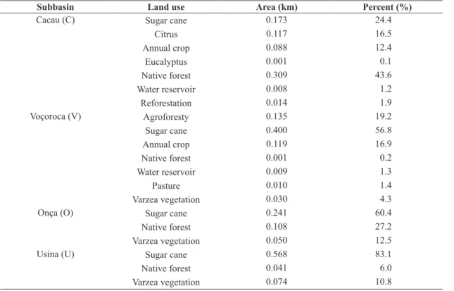
The land uses of each subbasin are distributed differently
(Figure 2, Table 1), with the predominant areas of sugarcane and native forest. At the Cacau-C subbasin, the use includes sugar cane, citrus, annual crop, eucalyptus, native forest, water reservoir and reforestation; at the Onça-O subbasin: sugar cane, native forest and wet lands vegetation; at the Usina-U subbasin: sugar cane, native forest and wetland vegetation, and at the Voçoroca-V subbasin: agroforesty, sugar cane, annual crop, native forest, water reservoir, pasture and wetland vegetation.
The morphometric parameters of each subbasin were directly calculated following the methodology describe on Pissarra et al. (2004), from the vector data extracted at the topographic map of São Domingos watershed (Instituto Brasileiro de Geografia e Estatística, 1971). The data
includes area (ha), perimeter (km), maximum lenght (km), maximum width (km), stream lenght (km), high altitude
Simedo, M.B.L. et al.
Braz. J. Biol., 2018 , vol. 78, no. 4, pp. 625-635 628 628/635
Figure 2. Land use of each subbasin at the Córrego da Olaria Basin, Pindorama, São Paulo State. Table 1. Percentage of land use of the subbasins at the Córrego da Olaria Basin.
Subbasin Land use Area (km) Percent (%)
Cacau (C) Sugar cane 0.173 24.4
Citrus 0.117 16.5
Annual crop 0.088 12.4
Eucalyptus 0.001 0.1
Native forest 0.309 43.6
Water reservoir 0.008 1.2
Reforestation 0.014 1.9
Voçoroca (V) Agroforesty 0.135 19.2
Sugar cane 0.400 56.8
Annual crop 0.119 16.9
Native forest 0.001 0.2
Water reservoir 0.009 1.3
Pasture 0.010 1.4
Varzea vegetation 0.030 4.3
Onça (O) Sugar cane 0.241 60.4
Native forest 0.108 27.2
Varzea vegetation 0.050 12.5
Usina (U) Sugar cane 0.568 83.1
Native forest 0.041 6.0
Varzea vegetation 0.074 10.8
fits a plane to the z-values of a 3 × 3 cell neighborhood
around the processing or center cell. The slope value of this plane is calculated using the average maximum technique (Burrough and McDonell, 1998).
3. Results
Table 2. Morphometric characteristics* of the subbasins at the Córrego da Olaria Basin.
Subbasin Area(ha) Perimeter(km) (km)L (km)W (km)Sl (m)Ha (m)La (%)S
Cacau (C) 70.88 3.33 1.11 0.76 0.82 601 555 6.36
Onça (O) 39.56 2.65 0.94 0.70 0.69 612 570 7.81
Usina (U) 68.08 3.31 1.08 0.93 0.95 615 570 6.99
Voçoroca (V) 71.78 3.63 1.21 0.89 0.84 604 545 5.65
*L = maximum lenght; W = maximum width; Sl = stream lenght; Ha = high altitude; La = low altitude; S = slope.
The data obtained from the dimensional morphometric characteristics of each subbasin (Table 2) showed that the subbasin (V) has the largest area, followed by (C), (U) and (O). The highest perimeter values were found in the subbasin (V), followed by (C), (U) and (O), with the same sequence for the maximum length. The maximum
width was identified in the subbasin (U), followed by the
subbasin (V), (C) and (O). The highest value for stream length (spring drainage net) was for the subbasin (U), followed by (V), (C) and (O).
The higher altitude was observed at the subbasin (U), followed by (O), (V) and (C), and the altimetric amplitude was 46 meters for (C); 42 meters to (O), 45 meters to (U) and 59 meters to (V). The subbasin with the highest slope (7.81%) was (O), followed by (U), (C) and (V). According to Oliveira et al. (1999), the subbasins in the Córrego da Olaria Basin presented relief soft undulating in their slope classes. There is no stepped slopes, and the average slope of the subbasins varied from 5.65% to 7.81%.
The percentage of land use for each subbasin can be observed at Table 1 and Figure 2.
Land use metrics varied from areas of sugarcane (60.4%) to native forest (27.2%), which are the predominant areas. The land conversion and the associated impacts throughout the watershed is discussed and to characterize the rate of each land use, and the measure of the extent and percent of each use can be seen on Table 1 and Figure 2.
The surface water quality distribution among the subbasin
showed significant differences (Table 3; Figures 3 and 4). These parameters included total nitrogen (mg L-1),
total phosphorus (mg L-1), nitrate (mg L-1 NO 3- – N),
fecal coliforms (NMP/100ml), hardness (mg L-1 CaCO 3),
ammonium (mg L-1 – N) and temperature (T °C), shown
on Figures 3 and 4.
To better understanding the natural condition of the
water flowing in the subbasins streams, the total nitrogen
(mg L-1) ranged from 0.30 to 1.30 mg L-1 in Cacau;
0.10 to 1.72 mg L-1 in Onça; 0.30 to 1.72 mg L-1 in Usina
and 0.20 to 1.72 mg L-1 in Voçoroca (Table 3; Figure 3a).
The mean concentration was 0.63-0.69 mg L-1. During
the assessed period, the total phosphorus concentration increased slightly from 0.01 to 0.04 mg L-1 in all subbasins
(Figure 3b).
The hardness parameter (mg L-1 CaCO
3) were highest at
the Onça subbasin, ranging from 54.92 to 72.03 mg L-1 CaCO 3
(Figure 4a). Nitrate (mg L-1 NO
3- – N), presented
the highest value in Cacau subbasin, ranging
from 2.70 to 12.29 mg L-1 NO 3
- – N, (Table 3; Figure 3c).
The total ammonia (mg L-1 – N) presented higher value
and greater variability at the Voçoroca subbasin, increasing from 0 to 0.124 mg L-1 – N and higher median value at
the Usina subbasin, increasing from 0 to 0.037 mg L-1 – N
(Figure 4b). The fecal coliforms (NMP/100ml) showed the highest values at the Usina and Voçoroca subbasins (Table 3; Figure 3d). The temperature (T °C) was major at Voçoroca subbasin, and showed a value of 28.66 °C,
differing from the other subbasins that showed an average
number of 22.6 °C to 18.4 °C (Table 3; Figure 4c).
4. Discussion
The watershed is an open system and offers continuous
exchange of matter and energy by the pedosphere, the atmosphere, the hydrosphere and the biosphere, which provides water percolation and the biological processes. In this study the subbasins is a structural geologic feature within Córrego da Olaria Basin that supplies water to São Domingos Watershed. This ecosystem is characterized
by bodies of water such as the springs that is influenced by geochemical soil and rocks that drain as well as the
interference of the climate and rainfall in their land uses (Sun et al., 2016; Yan et al., 2016). The structures of the basin ecosystems are interconnected between abiotic and biotic materials present in the environment. The integrated analysis in land uses and water monitoring in space (subbasins) and time (dry season and rainy season) allows to evaluate the possible degradation in water quality interrelated to land uses and soil management (Tundisi, 2008; Ding et al., 2016).
The water quality parameters were measured to verify the suitability of water for a particular use based on selected physical, chemical and biological characteristics. The measured and analyzed characteristics of the water such as total water temperature (°C), total nitrogen (mg L-1),
total phosphorus (mg L-1), hardeness (mg L-1 CaCO 3),
nitrate (mg L-1 NO 3
- – N), ammonium (mg L-1 – N), fecal
coliforms (NMP/100ml) (Tables 3 and 4; Figures 3 and 4) were compared to numeric standards and guidelines and to each subbasin (Figures 1 and 2), considering an ecosystem
to decide if the water is suitable for a specific use.
Simedo, M.B.L. et al.
Braz. J. Biol., 2018 , vol. 78, no. 4, pp. 625-635
630
630/635
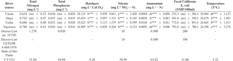
Table 3. The values of total nitrogen, total phosphorus, hardness, nitrate, ammonium, fecal coliforms and temperature in the subbasin Cacau (C); Onça (O); Usina (U) and Voçoroca (V), according to the limit values allowed by CONAMA 357/2005 and CETESB 8.468/1976.
River source
Total Nitrogen
(mg L-1)
Total Phosphorus
(mg L-1)
Hardness
(mg L-1 CaCO
3)
Nitrate (mg L-1 NO
3- – N)
Ammonium (mg L-1 – N)
Fecal Coliforms E. coli (NMP/100ml)
Temperature (T°C)
Cacau 0.634 (ns) ± 0.33 0.036 (ns) ± 0.028 38.125 b*** ± 5.858 9.661 a*** ± 2.420 0.0064 ab*** ± 0.008 235.3 (ns) ± 286.3 20.964 ab*** ± 1.123 Onça 0.743 (ns) ± 0.47 0.035 (ns) ± 0.019 63.654 a*** ± 5.097 1.332 b*** ± 0.145 0.0058 b*** ± 0.007 491.0 (ns) ± 396.2 20.679 b*** ± 1.491 Usina 0.686 (ns) ± 0.40 0.032 (ns) ± 0.020 35.622 b*** ± 3.115 1.279 b*** ± 0.399 0.0164 a*** ± 0.011 772.0 (ns) ± 891.6 20.665 b*** ± 1.413 Voçoroca 0.786 (ns) ± 0.41 0.036 (ns) ± 0.016 36.909 b*** ± 4.858 0.264 b*** ± 0.133 0.0093 ab*** ± 0.006 792.0 (ns) ± 700.3 24.298 a*** ± 3.270 Decree-Law
no. 357/05
1.270 0.020 - 10 0.500 200
-Decree-Law CETESB 8.468/1976 State of São
Paulo
- - - 10 0.500 100
-CV (%) 31.64 44.08 9.36 38.40 63.62 11.80 5.32
***p<0.0001. The means with the same letter area not significantly different from each other (Tukey test, p < 0.05); (ns) means not significant to test; the significance of values is in keeping with the ANOVA
Figure 4. Qualitative values of hardness (mg L-1 CaCO
3), ammonium (mg L
-1 – N) and temperature (T °C) at the Cacau (C);
Onça (O); Usina (U) and Voçoroca (V) subbasins.
Figure 3. Qualitative values of total nitrogen (mg L-1), total phosphorus (mg L-1), nitrate (mg L-1 NO
3- – N) and fecal
Simedo, M.B.L. et al.
Braz. J. Biol., 2018 , vol. 78, no. 4, pp. 625-635 632 632/635
(Figure 3a,b,c,d). These quantitative measurements must be constantly monitoring to comprehend the water quality of the subbasins, that are the sources of supply water to cities.
The water analysis identifies that the parameters
analised is associated to impacts throughout the subbasins, characterized by the rate of crop uses, forest and wetland. The measure of the extent and rate of change in impervious surface coverage and quantifying the potential impacts of land conversion to water quality.
The results of multiple comparisons indicated that there were variations in all of the water quality parameters between the subbasins (Table 3; Figures 3 and 4). Nitrogen, in the form of nitrate, nitrite or ammonia, is a necessary nutrient for plant growth (Food and Agriculture Organization of The United Nations, 1993) and is used in agricultural practices. Nitrogen can be found in the aquatic environment, and is present with low values in water, instead of Onça that exhibited values greater than the limit stipulated by Brazilian legislation (Figure 3a). This is due to the accumulation of nutrients derived from agricultural activities. The results were also related to the high period of precipitation (Table 4), showed significant
differences between dry and rainy seaons for this parameter. The subbasins that present differet crops (Cacau)
presented high values of nitrate (Table 3; Figure 3c;), due to those pesticide compounds that are already used in agriculture. The concentration of nitrate was high in
agricultural areas, and this fact can be justified by the
intensive use of fertilizers and pesticides in citrus and annual crops. The same process is reported in studies developed by Ding et al. (2016) and Moruzzi et al. (2012).
If excess nitrate are found in the crop fields, the drained
water introduces the element into the water courses (Ding et al., 2016), which will drain into other rivers and reach the São Domingos basin. Nutrients such as nitrogen, nitrate and phosphorus are essential for plant and animal growth, but the excess of certain nutrients in water can
cause a number of adverse ecological and health effects
(Maucieri et al., 2014).
The excess of phosphorus was shown in almost all the subbasins. The average values were higher than the limit value allowed by CONAMA (Figure 3b) and can cause the development of eutrophication of rivers and reservoirs (Tundisi, 2008). The phosphorus element in nature comes from the dissolution of the soil and the decomposition of organic matter. The parameter is present in all subbasins (Table 3; Figure 2b), with a higher value at the Cacau 0.105 mg L-1 and Usina 0.076 mg L-1.
Considering that the subbasin is essentially rural and has many agricultural crops (Figure 2), this fact confirms that the land use and management activities have increased the concentration of phosphorus, which resulted in higher levels at the water sampled sites, even in dry and rainy season (Table 4).
Fecal contamination by fecal coliform parameter was
identified at all sampling points (Figure 3d), with highest values in the water of Usina and Voçoroca subbasins, both with 2419.6 NMP/100ml. The presence of fecal coliform bacteria in aquatic environments indicates that the water has been contaminated with the fecal material of man or other animals. In those areas have warm-blooded animals of the local fauna, such as an expressive population of Hydrochoerus hydrochaeris (capybaras) that come into contact with water, and at the time this occurred, the source water may have been contaminated by pathogens or disease producing bacteria or viruses which can also exist in fecal material, even in dry or rainy seasons (Table 4). The presence of Escherichia coli bacteria in food and water is an indicator of fecal contamination, that is, of human waste or of warm-blooded animals (Ponath et al., 2016). The presence of fecal contamination is an indicator that a potential health
risk exists for individuals exposed to this water.
The hardness parameter does not present detection limit values established by CONAMA Resolution 357/2005 and Table 4. Values of total nitrogen, total phosphorus, hardness, nitrate, ammonium, fecal coliforms in Rainy and Dry Seasons.
Clima Variable Mean Std. Dev. Minimum Maximum
Rainy Total Nitrogen 0.7828 a 0.46 0.10 1.72
Dry mg L-1 0.5713 b 0.19 0.30 1.01
Rainy Total Phosphorus 0.0371 a 0.02 0.01 0.11
Dry mg L-1 0.0340 a 0.02 0.01 0.08
Rainy Hardness 43.8128 a 13.60 24.30 72.03
Dry 43.1069 a 10.88 34.01 66.82
Rainy Nitrate 2.9213 a 3.90 0.10 11.26
Dry mg L-1 3.8231 b 4.32 0.33 12.29
NO3- – N
Rainy Amononia 0.0094 a 0.01 0.00 0.04
Dry mg L-1 – N 0.0134 b 0.01 0.00 0.03
Rainy Phecal Coliform 691.3031 a 621.70 23.80 2419.60
Dry NMP/100ml 367.7660 a 629.04 2.00 2419.60
Rainy Temperature 22.35 a 2.64 19.00 28.66
CETESB 8.468/1976 (Companhia Ambiental do Estado de São Paulo, 1976), however it is important for the evaluation
of the concentration of alkaline earth metals ions, especially
calcium and magnesium. The Onça subbasin showed the highest hardness value of 72.03 mg-CaCO3 (Figure 4a),
differing statistically from the others areas (Table 3). This water samples can be explained due to the geology of the site and nutrients from forest areas, and the dissolution
of rocks and minerals. Oliveira et al. (2014) found high values of hardness in waters where there was a higher
concentration of rocks containing calcium and magnesium.
The concentration of ammonium (NH4+) or ammonium
ion is the ionized form of Ammonia (NH3) in streams. The ammonia content may be present in surface or groundwater, usually by the decomposition of residual materials of plant or animal origin. The parameter was found at the sampling points, with highest values in water at Voçoroca and Usina subbasins (Table 3, Figure 4b) and on dry season, and those
subbasins have a remarkable presence of diversified fauna
of mammals and agricultural crops. Ammonium levels in the water may be related to the use of ammonia sulfate (NH4)2SO4 in agricultural practices in the fields in the basin, in addition to the presence of urine and animal feces that approach the water bodies. Similar contaminations were
identified by Delatore da Silva et al. (2014).
The temperature of the water is not a parameter in CONAMA Resolution 357/2005 and CETESB 8.468/1976,
but it is considered very important because it reflects the
seasonal variations of the physical-chemical parameters of the water. The highest value of temperature was observed at the Voçoroca subbasin 28.66 °C in rainy season (Figure 4c; Table 4), which presents an agricultural area in its
surroundings and an unconsolidated reforestation, differing
from other subbasins that are located in areas of native forest. The forested basins present lower water temperature levels (Arcova and Cicco, 1999). Marmontel and Rodrigues (2015) confirm that springs located in shading areas of riparian forest areas presented a lower mean temperature and lower amplitude.
The parameters used in the monitoring of the basin (total nitrogen, total phosphorus, hardness, nitrate, ammonium, fecal coliforms and temperature) indicated that the values
obtained differ at each sampling point, reflecting the effects
of land use on water quality. The results indicated that
there was significant correlation between land uses and
dry and rainy seasons to water pollution, and the subbasin that had the natural forest areas had less impacts on the
water quality, while the influence of the cultivated land
on the water quality was very high and remains a complex
correlation, what confirm the need of more studies related
to land uses changes. Besides, the impacts of the landscape diversity on the indicators of water quality within the watershed were also analyzed, the result of which indicated
there was a significant positive relationship between them.
The analyses of the water related to land uses changes are necessary to legislation. The National Land Use Policy is a necessary law, and the policy should cover land use and land management, and should be brought into line with
international norms and standard operating procedures,
in order to reflect the political changes in Watershed
Management Plan. The use of land by the people must be supervised to preserve the natural resources.
4. Conclusions
Water quality differs at each subbasin and is linked
to land uses or the conservation status of river basins. The evaluated parameters of total nitrogen, total phosphorus, hardness, nitrate, ammonium, fecal coliforms and temperature indicated that upstream soil use is altering the water quality of the Córrego da Olaria Basin.
Acknowledgements
The authors thank the FAPESP (Fundação de Amparo à Pesquisa do Estado de São Paulo) for the financial and institutional support to carry out this project.
References
AGÊNCIA NACIONAL DE ÁGUAS – ANA, 2005 [viewed 15 February 2016]. Panorama da qualidade das águas superficiais no Brasil. Cadernos de Recursos Hídricos [online]. Brasilia: ANA. 176 p. Avaliable from: http://portalpnqa.ana.gov.br/Publicacao/ PANORAMA_DA_QUALIDADE_DAS_AGUAS.pdf AMERICAN PUBLIC HEALTH ASSOCIATION – APHA, 1999 [viewed 25 March 2016]. Standard methods for the examination of water and wastewater [online]. 20th ed. Washington: APHA. 521 p. Avaliable from: http://www.mwa.co.th/download/file_upload/ SMWW_1000-3000.pdf
Simedo, M.B.L. et al.
Braz. J. Biol., 2018 , vol. 78, no. 4, pp. 625-635 634 634/635
BURROUGH, P.A. and MCDONELL, R.A. 1998. Principles of geographical information systems. 2nd ed. New York: Oxford
University Press. 190 p.
CARVALHO, K.Q., LIMA, S.B., PASSIG, F.H., GUSMÃO, L.K., SOUZA, D.C., KREUTZ, C., BELINI, A.D. and ARANTES, E.J., 2015. Influence of urban area on the water quality of the Campo River basin, Paraná State. Brazilian Journal of Biology = Revista Brasileira de Biologia, vol. 75, no. 4, suppl. 2, pp. 96-106. PMid:26628235.
CENTRO DE PESQUISAS METEOROLÓGICAS E CLIMÁTICAS APLICADAS À AGRICULTURA – CEPAGRI, 2016. Clima dos municípios paulistas [online]. Campinas: CEPAGRI. Avaiable from: http://www.cepagri.unicamp.br/
CHAVES, H.M.L. and SANTOS, L.B., 2009. Ocupação do solo, fragmentação da paisagem e qualidade da água em uma pequena bacia hidrográfica. Revista Brasileira de Engenharia Agrícola e Ambiental, vol. 13, (suppl.), pp. 922-930. http://dx.doi.org/10.1590/ S1415-43662009000700015.
COMPANHIA AMBIENTAL DO ESTADO DE SÃO PAULO – CETESB, 1976 [viewed 4 August 2016]. Lei estadual nº 997, de 31 de maio de 1976. Dispõe sobre o controle da poluição do meio ambiente. Assembleia Legislativa do Estado de São Paulo, São Paulo, 8 september. 76 p. Available from: http://licenciamento.cetesb. sp.gov.br/legislacao/estadual/decretos/1976_Dec_Est_8468.pdf DING, J., JIANG, Y., LIU, Q., HOU, Z., LIAO, J., FU, L. and PENG, Q., 2016. Influences of the land use pattern on water
quality in low-order streams of the Dongjiang River basin, China:
a multi-scale analysis. The Science of the Total Environment, vol. 551-552, pp. 205-216. PMid:26878633. http://dx.doi.org/10.1016/j. scitotenv.2016.01.162.
DUARTE-DOS-SANTOS, A.K., CUTRIM, M.V.J., FERREIRA, F.S., LUVIZOTTO-SANTOS, R., AZEVEDO-CUTRIM, A.C.G., ARAÚJO, B.O., OLIVEIRA, A.L.L., FURTADO, J.A. and DINIZ, S.C.D., 2016. Aquatic life protection index of an urban river Bacanga basin in northern Brazil, São Luís - MA. Brazilian Journal of Biology = Revista Brasileira de Biologia, vol. 77, no. 3, pp. 602-615. PMid:27706393. http://dx.doi.org/10.1590/1519-6984.01016.
FAUSTINO, A.B., RAMOS, F.F. and SILVA, S.M.P., 2014. Dinâmica temporal do uso e cobertura do solo na Bacia Hidrográfica do Rio Doce (RN) com base em sensoriamento remoto e SIG: uma contribuição aos estudos ambientais. Sociedade e Território, vol. 26, no. 2, pp. 18-30.
FERREIRA, J.E.V., PINHEIRO, M.T.S., SANTOS, W.R.S. and SILVA-MAIA, R., 2016. Graphical representation of chemical periodicity of main elements through a boxplot. Educación en la Química, vol. 27, pp. 209-216.
FOOD AND AGRICULTURE ORGANIZATION OF THE UNITED NATIONS – FAO, 1993 [viewed 10 June 2016]. The state of food and agriculture [online]. Rome: FAO. Water policies and agriculture, part III. Available from: http://www.fao.org/ docrep/003/t0800e/t0800e00.htm
FOOD AND AGRICULTURE ORGANIZATION OF THE UNITED NATIONS – FAO, 2015 [viewed 10 June 2016]. The state of food and agriculture – social protection and agriculture: breaking the cycle of rural poverty [online]. Rome: FAO. 129 p. Available from: http://www.fao.org/publications/sofa/2015/en/ GIRI, S. and QIU, Z., 2016. Understanding the relationship of land uses and water quality in twenty first century: a review.
Journal of Environmental Management, vol. 173, pp. 41-48. PMid:26967657. http://dx.doi.org/10.1016/j.jenvman.2016.02.029. INSTITUTO BRASILEIRO DE GEOGRAFIA E ESTATÍSTICA – IBGE, 1971 [viewed 1 January 2017]. Cartas topográficas vetoriais do mapeamento sistemático [online]. Carta do Brasil – Catanduva folha SF-22-X-D-II-1. Escala 1:50.000. Available from: http://www.ibge.gov.br/home/geociencias/download/ arquivos/index1.shtm
INSTITUTO BRASILEIRO DE GEOGRAFIA E ESTATÍSTICA – IBGE, 2016 [viewed 5 January 2017]. Informações sobre os municípios brasileiros [online]. Available from: http://www. cidades.ibge.gov.br
INSTITUTO DE PESQUISAS TECNOLÓGICAS DO ESTADO DE SÃO PAULO – IPT, 2008 [viewed 10 July 2016]. Plano de bacia da unidade de gerenciamento de recursos hídricos da bacia do Turvo/Grande (UGRHI 15) [online]. São José do Rio Preto: IPT. 172 p. Available from: http://www.sigrh.sp.gov.br/public/ uploads/documents/7077/relatorio-final_plano-turvo_grande.pdf JUNG, K.Y., LEE, K.L., IM, T.H., LEE, I.J., KIM, S., HAN, K.Y. and AHN, J.M., 2016. Evaluation of water quality for
the Nakdong River watershed using multivariate analysis.
Environmenatl Technology & Innovation, vol. 5, pp. 67-82. http://
dx.doi.org/10.1016/j.eti.2015.12.001.
KÖPPEN, W. 1948. Climatologia: conunestudio de los climas de latierra. México: Fondo de Cultura Econômica, 479 p.
LOPES, M.C. 2011. Ações de educação ambiental e monitoramento da água no córrego da Olaria, Apta-Pindorama, SP. Jaboticabal: Faculdade de Ciências Agrárias e Veterinárias, Universidade Estadual Paulista, 64 p. Dissertação de Mestrado em Agronomia, Programa de Pós-Graduação em Ciência do Solo.
MARMONTEL, C.V.F. and RODRIGUES, V.A., 2015. Parâmetros indicativos para qualidade da água em nascentes com diferentes coberturas de terra e conservação da vegetação ciliar. Revista Floresta e Ambiente, vol. 22, no. 2, pp. 171-181. http://dx.doi. org/10.1590/2179-8087.082014.
MASSART, D.L., SMEYERS-VERBEKE, J., CAPRON, X. and SCHLESIER, K., 2005. Visual presentation of data by means of box plots. LC GC Europe, vol. 18, pp. 215-218.
MAUCIERI, C., SALVATO, M., TAMIAZZO, J. and BORIN, M., 2014. Biomass production and soil organic carbon accumulation in a free water surface constructed wetland treating agricultural wastewater in North Eastern Italy. Ecological Engineering, vol. 70, pp. 422-428. http://dx.doi.org/10.1016/j.ecoleng.2014.06.020. MORUZZI, R.B., CONCEIÇÃO, F.T., SARDINHA, D.S., HONDA, F.P. and NAVARRO, G.R.B., 2012. Avaliação de cargas difusas e simulação de autodepuração no córrego da água branca, Itirapina (SP). Geociências, vol. 31, no. 3, pp. 447-458.
MOSCA, A.A.O. 2003. Caracterização hidrológica de duas microbacias visando a identificação de indicadores hidrológicos para o monitoramento ambiental de manejo de florestas plantadas. Piracicaba: Escola Superior de Agricultura Luis de Queiroz, Universidade de São Paulo, 96 p. Dissertação de Mestrado em Recursos Florestais.
OLIVEIRA, J.B., CAMARGO, M.N., ROSSI, M. and CALDERANO FILHO, B. 1999. Mapa pedológico do Estado de São Paulo: legenda expandida. Campinas: Instituto Agronômico, Embrapa Solos. 64 p. Escala 1:500.000.
subterrâneas na região da Lagoa da Confusão - TO - Brasil. Ambiência Guarapuava (PR), vol. 10, no. 1, pp. 281-302. PISSARRA, T.C.T. 2002. Análise da bacia hidrográfica do Córrego Rico na sub-região de Jaboticabal, SP: comparação entre imagens TM-LANSAT 5 e fotografias aéreas verticais. Jaboticabal: Faculdade de Ciências Agrárias e Veterinárias, Universidade Estadual Paulista. 132 p. Tese de Doutorado em Agronomia, Programa de Pós-Graduação em Produção Vegetal. PISSARRA, T.C.T., MARCUSSI, A.B., LEÃO, G.R., GALBIATTI, J.A., BORGES, M.J. and CAMPOS, S., 2013. Environmental adaptation of the source of the subbasin of Rico Stream, Monte Alto - SP, Brazil. Engenharia Agrícola, vol. 33, no. 2, pp. 303-311. http://dx.doi.org/10.1590/S0100-69162013000200009. PISSARRA, T.C.T., POLITANO, W. and FERRAUDO, A.S., 2004. Avaliação de características morfométricas na relação solo-superfície da bacia hidrográfica do Córrego Rico, Jaboticabal (SP). Revista Brasileira de Ciência do Solo, vol. 28, no. 2, pp. 297-305. http://dx.doi.org/10.1590/S0100-06832004000200008. PONATH, F.S., VALIATTI, T.B., SOBRAL, F.O.S., ROMÃO, N.F., ALVES, G.M.C. and PASSONI, G.P., 2016. Avaliação da higienização das mãos de manipuladores de alimentos do Município de Ji-Paraná, Estado de Rondônia, Brasil. Pan-Amazônica de Saúde, vol. 7, no. 1, pp. 63-69. http://dx.doi.org/10.5123/S2176-62232016000100008.
SILVA, D.D., MIGLIORINI, R.B., SILVA, E.C., LIMA, Z.M. and MOURA, I.B., 2014. Falta de saneamento básico e as águas subterrâneas em aquífero freático: região do bairro Pedra Noventa, Cuiabá (MT). Engenharia Sanitaria e Ambiental, vol. 19, no. 1, pp. 43-52. http://dx.doi.org/10.1590/S1413-41522014000100005. SILVINO, R.F. and BARBOSA, F.A.R., 2015. Eutrophication
potential of lakes: an integrated analysis of trophic state,
morphometry, land occupation, and land use. Brazilian Journal
of Biology = Revista Brasileira de Biologia, vol. 75, no. 3, pp. 607-615. http://dx.doi.org/10.1590/1519-6984.18913. SOUZA, M.M. and GASTALDINI, M.C.C., 2014. Avaliação da qualidade da água em bacias hidrográficas com diferentes impactos antrópicos. Engenharia Sanitaria e Ambiental, vol. 19, no. 3, pp. 263-274. http://dx.doi.org/10.1590/S1413-41522014019000001097. STRAHLER, A.N., 1957. Quantitative analysis of watershed geomorphology. Transactions - American Geophysical Union, vol. 6, no. 38, pp. 913-920. http://dx.doi.org/10.1029/TR038i006p00913. SUN, W., XIA, C., XU, M., GUO, J. and SUN, G., 2016. Application of modified water quality indices as indicator to assess
the spatial and temporal trends of water quality in the Dongjiang
River. Ecological Indicators, vol. 66, pp. 306-312. http://dx.doi.
org/10.1016/j.ecolind.2016.01.054.
TUNDISI, J.G., 2008. Recursos hídricos no futuro: problemas e soluções. Estudos Avançados, vol. 22, no. 63, pp. 7-16. http:// dx.doi.org/10.1590/S0103-40142008000200002.
UNITED STATES GEOLOGICAL SURVEY – USGS, 2017 [viewed 10 January 2017]. Credit: U.S. geological survey. [online]. United States: Department of the Interior. Available from: https:// www2.usgs.gov/pubprod/LandSat8
VALLE JUNIOR, R.F., VARANDAS, S.G., SANCHES FERNANDES, L.F. and PACHECO, F.A., 2014. Groundwater quality in rural watersheds with environmental land use conflicts. The Science of the Total Environment, vol. 493, pp. 812-827. PMid:25000577.
http://dx.doi.org/10.1016/j.scitotenv.2014.06.068.
YAN, W., LI, J. and BAI, X., 2016. Comprehensive assessment
and visualized monitoring of urban drinking water quality.