INSTITUTE OF GEOSCIENCES
Hydrogeological Conceptual Model of Sete Lagoas (MG) and
Associated Implications
of Urban Development in Karst Region
Paulo Henrique Ferreira Galvão
Supervisor: Dr. Ricardo Hirata
DOCTORAL THESIS
Mineral Resources and Hydrogeology Graduate Program
INSTITUTO DE GEOCIÊNCIAS
Modelo Hidrogeológico Conceitual de Sete Lagoas (MG) e
Implicações Associadas ao Desenvolvimento Urbano em Regiões
Cársticas
Paulo Henrique Ferreira Galvão
Orientador: Dr. Ricardo Hirata
TESE DE DOUTORAMENTO
Programa de Pós-graduação em Recursos Minerais e Hidrogeologia
Autorizo a reprodução e divulgação total ou parcial deste trabalho, por qualquer meio
convencional ou eletrônico, para fins de estudo e pesquisa, desde que citada a
fonte.
Ficha catalográfica preparada pelo Serviço de Biblioteca e Documentação do Instituto de Geociências da Universidade de São Paulo
Galvão, Paulo Henrique Ferreira
Modelo hidrogeológico conceitual de Sete Lagoas (MG) e implicações associadas ao desenvolvimento urbano em regiões cársticas / Paulo Henrique Ferreira Galvão. – São Paulo, 2015.
124 p. : il.
Tese (Doutorado) : IGc/USP Orient.: Hirata, Ricardo
i
This thesis is dedicated exclusively to my mom Odete Ferreira Galvão, an example of
dignity, dedication, devotion and love. To this woman, my safe haven, I thank all her
values and principles that were transferred and that formed the basis of what I am
today.
ii
"Try not to become a man of success, but rather try to become a man of value."
Albert Einstein
"Não sei, só sei que foi assim!"
iii
ACKNOWLEDGMENTS
The development of this doctoral thesis has been, along this 4 years journey, a
rewarding experience. It would not have come to fruition without the contributors
listed below, who spent directly or indirectly their busy time supporting and helping
me in the best way it could be.
First, I would like to thank deeply my mom Odete Ferreira Galvão for dedication
and patience. You were and are the key of my success in the past, present and in the
future. I would also like to thank my family for supporting me, specially my aunts
Irene Ferreira Galvão and Ruth Ferreira Galvão for helping me in the worst times.
A special thanks to Dr. Ricardo Hirata, my supervisor, for his excellent support
and patience throughout these four years. Without his supervision and devices, this
thesis would be more difficult. A special thanks to Dr. Todd Halihan, my
co-supervisor, for his great support during my exchange period at Oklahoma State
University (Go Pokes!), in Stillwater, USA. It was a privilege to have had both of them
as supervisors, which I could enjoy their experiences and wisdoms. The discussions
and observations we had during all this work period were immensely important for my
formation as a researcher and as a person
I gratefully acknowledge Servmar Environmental & Engineering and São Paulo
Research Foundation (FAPESP) [
FAPESP - Fundação de Amparo à Pesquisa do
Estado de São Paulo
] for supporting and funding my Doctoral studies. To Water
Supply and Sewage Service (SAAE) [
SAAE - Serviço de Abastecimento de Água e
Esgoto
] for providing me with the necessary data, as well as for treating me in a very
friendly way, specially to Fátima L'Abbate and Tereza Cristina Luppi Miranda.
My sincere thanks for such a fruitful collaboration to the Servmar's project
partners: Arnaldo Cordeiro, Daniela Barbati, Gilcélia Cristina Barboza, and Saulo
Bertolino for being a good friends and helping me in fieldworks and giving me
indispensable advices. Their great contributions were essentials, as well as the great
time we had together in numerous meetings, fieldworks, hangouts and pubs. We
started as good co-workers to become great friends. A very special thanks to Jorge
Peñaranda (Miguelito) for coordinating the project, and especially for becoming my
friend, helping me and giving me good advices in a very important moments.
iv
Batista, Marcus Ucci, Marcos Barbosa, and Sandra Guerra for the support, several
"hydrotalks" and the great time together hanging out. A special thank to Rafael
Terada, for the support in the fieldworks and the several chats about our theses and
future plans, and also for being part of the Tia Darcy band, a genuine "hydroband",
as the base guitar player and vocalist with Lucas Andreata (drummer) and Ricardo
Saito (bass player), all of them also from LAMO. All of you guys became great friends
of mine.
To all USP graduate colleagues, in which I had the pleasure to enjoy the
excellent companies and great friendships. A special thanks to Dr. Geane Carolina
Cavalcante, for the great contributions in the chapter about structural geology and for
the essential tips, and to Prof. Dr. Renato Paes de Almeida for providing the
TinyPerm II portable hand-held permeameter.
To my American friends Kyle Spears (The Survivor Man!) and Kaitlyn Beard
(KB) for correcting my English grammar mistakes and helped me a lot when I arrived
in Stillwater, but the most important thing, for becoming my friends. You both are part
of a select group of special people, which I will never forget, such as Jordan McCall,
Britney Temple, Jon Fields, and my American rock band integrants Jared Oxford
(bass player), Nick Richards (base guitar player), Noel Treatwell (drummer), and Nick
Nease (vocalist). To my Egyptian friends, for the great time together playing soccer
every Friday night, even in negative Celsius temperatures, and especially to Ibrahim
Sabri, for have been a good roommate for one year and for showing me how
beautiful is his religion. My time in Stillwater with all those people was unforgettable.
To my close friends Neto Camarinha, Victor Camarinha, Ely Costa, and Glauco
Oliveira for being part of my life since I was a child. I would also like to thank Mauricio
Rodrigues and Raquel Pistilli, for treating me as part of their house in São Paulo in a
very receptive and friendly way for almost four years. For those who I eventually did
not mention here, my sincerely acknowledge for everything.
v
ABSTRACT
This research integrated geological, hydrogeological, geochemical, and stable
isotope studies conducted in the municipality of Sete Lagoas (MG), Brazil, in order to
understand the water circulation in a karst terrain and to propose alternatives for a
better water use, aiming to avoid geotechnical problems. The area is constituted by
Neoproterozoic limestones from the Sete Lagoas Formation, where karst conduits
were developed, giving origin to the homonymous aquifer, which is covered by
Cenozoic unconsolidated sediments and, occasionally, by Neoproterozoic
metasedimentary rocks from the Serra de Santa Helena Formation. It was observed
that in this aquifer the primary porosity is very low and the secondary porosity
(micro-fractures) is also reduced, due to the filling by calcite. The great volume of
groundwater migrates through the tertiary porosity characterized by two dominant
solutionally enlarged bedding planes and, to a lesser extent, by sub-vertical enlarged
fractures. The recharge, related to rainfall occurring from October to December, takes
place through sinkholes, caves entrances, and where the limestones are under the
Cenozoic sediments. A detailed study evaluating the scale effects also allowed the
establishment of permeability distributions of the Sete Lagoas Aquifer. Other results
obtained also established that the groundwater extractions are associated to karst
geotechnical events located in the urbanized area of the municipality. The high
groundwater extractions make the shallowest solutionally enlarged bedding plane, in
some points, entirely in the unsaturated zone, causing geotechnical events. A
geotechnical map identifies five levels of risk, based on the lithology and the
groundwater level interaction. This type of mapping should guide the groundwater
extractions and caring the urban land occupation in Sete Lagoas, preventing or
delaying the occurrence of new subsidences or collapses.
vi
RESUMO
Esta pesquisa integrou estudos geológicos, hidrogeológicos, geoquímicos e de
isótopos estáveis no município de Sete Lagoas (MG), Brasil, com o objetivo de
entender a circulação da água em terreno cárstico e propor alternativas para o seu
melhor uso, a fim de se evitar problemas geotécnicos. A área é constituída por
calcários neoproterozoicos da Formação Sete Lagoas, onde se desenvolveram
condutos cársticos, dando origem ao aquífero homônimo, o qual está coberto por
sedimentos cenozoicos inconsolidados e, ocasionalmente,
por rochas
metasedimentares neoproterozoicas da Formação Serra de Santa Helena. Foi
observado que neste aquífero a porosidade primária é muito baixa e a secundária
(micro-fraturas) é igualmente reduzida, devido ao preenchimento por calcita. O
grande volume de água subterrânea migra através da porosidade terciária
caracterizada dominantemente por dois planos de acamamentos carstificados e, em
menor grau, por fraturas sub-verticais carstificadas. A recarga, relacionada às
chuvas que ocorrem no período de outubro a dezembro, se dá através de
sumidouros, entradas de cavernas e onde o calcário está sob os sedimentos
cenozoicos. Um detalhado estudo avaliando os efeitos de escala permitiu também o
estabelecimento da distribuição das permeabilidades do Aquífero Sete Lagoas.
Outros resultados obtidos também estabeleceram que as extrações de águas
subterrâneas estão associadas aos eventos geotécnicos cársticos localizados na
área urbana do município. A elevada extração das águas subterrâneas faz com que
o plano de acamamento carstificado mais raso, em algumas áreas, esteja
inteiramente na zona não saturada, provocando os eventos geotécnicos. Um mapa
de risco geotécnico identifica, a partir da litologia e do nível de água subterrânea,
cinco níveis. Este tipo de mapeamento deveria orientar as extrações e os cuidados
na ocupação do terreno urbano em Sete Lagoas, prevenindo ou retardando a
ocorrência de novas subsidências ou colapsos.
vii
SUMMARY
ACKNOWLEDGMENTS
iii
ABSTRACT
v
RESUMO
vi
SUMMARY
vii
CHAPTER 1: INTRODUCTION
1
1.1 Presentation
1
1.2 Objectives and justifications
1
1.3 Structure of this thesis
2
CHAPTER 2: SITE DESCRIPTION
4
CHAPTER 3: MATERIALS AND METHODS
9
3.1 Geological approaches
9
3.1.1 Geologic mapping
9
3.1.2 Subsurface lithologic contact
10
3.2 Hydrogeological approaches
10
3.2.1 Pumping tests
10
3.2.2 Stable isotopes samples
12
3.2.3 Geochemistry analysis
13
3.3 Georeferencing data and software
13
CHAPTER 4: KARST HYDROGEOLOGY: ORIGINS AND CONCEPTS
16
4.1 The origin of karst
17
4.2 Features and controls on the development of karst system
18
4.2.1 Recharge of karst aquifer (input control)
19
4.2.2 Hydraulic parameters (throughput control)
19
4.2.3 Discharge of karst aquifer (output control)
23
4.3 Karst landform
24
4.3.1 Sinkholes (Dolines)
24
4.3.2 Caves
24
4.3.3 Springs
25
4.3.4 Poljes
25
4.3.5 Karst valleys
25
4.3.6 Sinking streams
26
4.4 Human impacts on karst system
26
4.4.1 Groundwater contamination in karst aquifer
26
4.4.2 Induced subsidences
27
viii
CHAPTER 5: GEOLOGIC CONCEPTUAL MODEL OF THE MUNICIPALITY OF SETE
LAGOAS (MG, BRAZIL) AND THE SURROUNDINGS
32
1. Introduction
32
2. Site description
33
3. Methods
34
4. Results and discussions
36
4.1. Geologic mapping
36
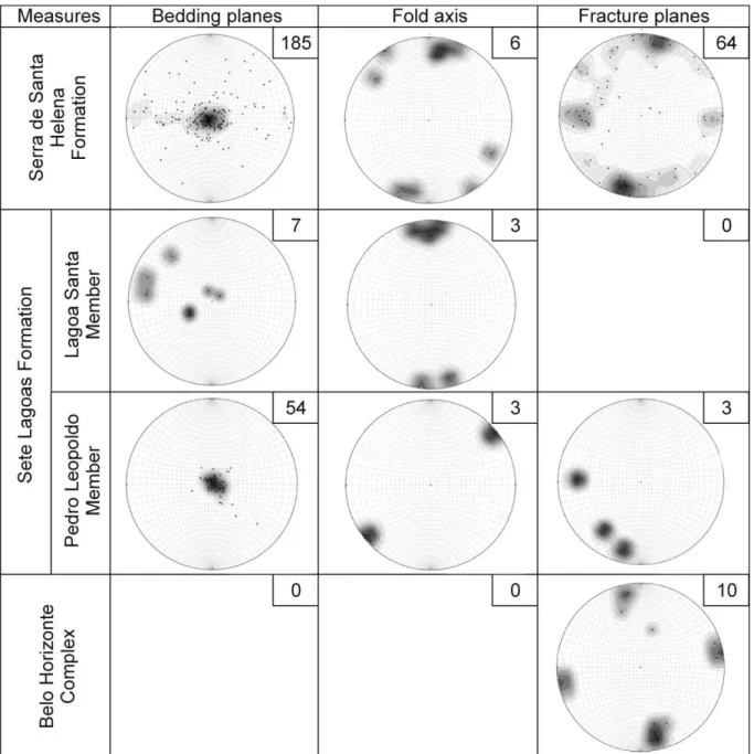
4.2. Structural geology
40
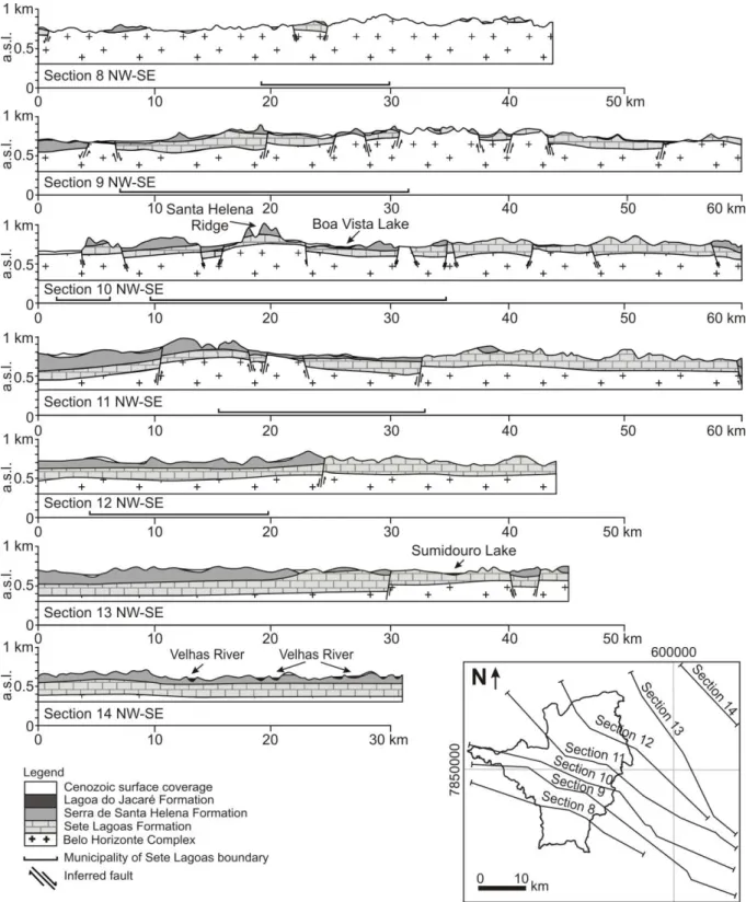
4.3. Spatial distribution of the geologic formations
42
4.4. Geologic conceptual model
46
5. Conclusion
49
CHAPTER 6: EVALUATING KARST GEOTECHNICAL RISK IN THE URBANIZED AREA
OF SETE LAGOAS, MINAS GERAIS, BRAZIL
52
1. Introduction
52
2. Site description
54
3. Methods
54
4. Results
57
4.1. Geology
57
4.2. Lithostructural contacts and spatial distribution
57
4.3. Locations of the subsidence/collapse events and hydrogeological correlation
59
4.4. Karst geotechnical risk evaluation
62
5. Discussion
62
6. Conclusion
64
CHAPTER 7: THE KARST PERMEABILITY SCALE EFFECT OF SETE LAGOAS, MG,
BRAZIL
69
1. Introduction
69
2. Site description
72
3. Methods
74
3.1. Permeability database
74
3.2. Permeability component data
76
3.3. Permeability combination models
78
4. Results
78
4.1. Sete Lagoas permeability database
78
4.2. Permeability feature sizes from inversion
83
4.3. Permeability combination model
84
5. Discussion
87
ix
CHAPTER 8: STABLE ISOTOPES AND GEOCHEMICAL STUDIES TO EVALUATE
FLOWPATHS AND RECHARGE AREAS IN AN URBAN KARST AQUIFER OF SETE
LAGOAS, MG, BRAZIL
97
1. Introduction
97
2. Site description
99
3. Methods
100
3.1 Stable isotopes
100
3.2 Geochemistry analysis
102
4. Results
102
4.1 Stable isotopes
102
4.2 Geochemistry
105
5. Discussion
110
5.1 Stable isotopes
110
5.2 Geochemistry
111
5.3 Water evolution and sources of recharge
113
6. Conclusion
116
CHAPTER 9: CONCLUSIONS
120
9.1 Geological features of Sete Lagoas and surroundings
120
9.2 Hydrogeological features of the city of Sete Lagoas
121
9.3 Groundwater evolution and source of recharges
123
9.4 Urban groundwater extraction and karst geotechnical risks
123
Doctoral Thesis 1 Galvão, P.H.F.
CHAPTER 1: INTRODUCTION
1.1 Presentation
The doctoral thesis was a result of a research that integrated geological,
hydrogeological, geochemical, and stable isotope studies conducted in the
municipality of Sete Lagoas, Minas Gerais state, Brazil. This region has a population
greater than 200,000, over an area of 538 km
2, where the urban development was
more intense in the central portion of this municipality. Geologically, the area is
located in the São Francisco Craton, where carbonate argillo-arenaceous sediments
are emplaced giving origin to the Bambuí Group. In this group, karst conduits in the
limestones from the Sete Lagoas Formation were developed, which are storing a
large amount of groundwater. Because of this, the current water supply is almost
entirely groundwater from the Sete Lagoas karst aquifer. As it is common in
developing countries like Brazil, mostly cities has rapid urban growth having not
always been guided by planning, reflecting sometimes in water supply problems for
local populations. These features also take place in Sete Lagoas, with an
aggravating factor: the location of this city in a karst region, which problems related to
geotechnical issues caused by groundwater exploitation, as well as problems in
water supply during dry season, are common. The results obtained in this
multidisciplinary research, where some methodologies used in this thesis were never
applied for karst regions, especially in Brazil, were used to understand the water
circulation in this karst terrain and its behaviors with others geological formations,
and then giving alternative responses for a better use of water, mitigating problems
related to that.
1.2 Objectives and justifications
Doctoral Thesis 2 Galvão, P.H.F.
these mechanisms is important because of the increasing demands on this karst
aquifer, which require users to have a better understanding of how it functions, so
that it can be properly utilized and protected, avoiding water resource degradations,
as well as facilitating stakeholder decision making in urban planning.
1.3 Structure of this thesis
This doctoral thesis is organized in the form of scientific papers, which were
published, accepted and submitted to international journals. Thus, each chapter can
be read relatively independently to the others. After the Chapter 1 "Introduction", it is
presented the Chapter 2 containing the site descriptions and its hydrogeological
features.
The Chapter 3 is about the main methods used in the research to understand
the circulation of groundwater and its relationships in karst terrains, while the Chapter
4 is the state of art "Karst hydrogeology: origins and concepts".
The Chapter 5 contains the paper "Geologic conceptual model of the
municipality of Sete Lagoas (MG, Brazil) and the surroundings", accepted in the
Anais da Academia Brasileira de Ciências [
Annals of the Brazilian Academy of
Sciences
] (Galvão et al. in press). This paper was important to understand, firstly, the
spatial distribution and the structural framework geometry to establish a new geologic
perspective of the region before developing the other papers.
Doctoral Thesis 3 Galvão, P.H.F.
The Chapter 7 contains the paper "The karst permeability scale effect of Sete
Lagoas, MG, Brazil", submitted in the Journal of Hydrology (Galvão et al. in review).
The Sete Lagoas karst aquifer was used to evaluate the permeability structure across
a range of scales in order to develop a quantitative model of permeable features that
is consistent across all scales of measurement, from matrix properties to
regional-scale flow. This aquifer has some wells that do not have measurable drawdown
during pumping due to high permeability. Based on bulk permeability measurements,
inverted estimate of the size of hydraulic features, and the permeability combination
forward modeling, the results indicated an increase in permeabilities from the matrix-
to well-scale, but a decrease of these parameters from well- to regional-scale due to
the localized development of karst bedding plane dissolution in one structurally
controlled region of the aquifer. The physical sizes of permeable features of the
aquifer are consistent across the scales of data collection and their geometry
provides a quantitative understanding of the scale effects of permeability
measurements.
The Chapter 8 presents the paper "Stable isotopes and geochemical studies to
evaluate flowpaths and recharge areas in an urban karst aquifer in Sete Lagoas, MG,
Brazil", to be submitted in the Annals of the Brazilian Academy of Sciences. The
main goal was identify indirectly the various sources and areas of recharge in the
karst area, its flowpaths, and surface-ground water interaction, which is important for
proper water resource management, avoiding eventual contaminations and other
future water quality problems. Analyzing data of stable isotopes
18O and
2H and
major ions measurements, it was possible to understand that the origin of
groundwater is directly from precipitation, having a limited period of recharge. In the
central urbanized area, where the karst aquifer is in contact with Cenozoic
unconsolidated sediments, there may be punctual superficial water infiltration. The
major ions concentrations presented the highest values at the same region, where
the most developed karstic structure was found in the Sete Lagoas Formation. These
data could suggest larger water reservoir indicating more mineralization, which are in
concordance with the geologic information.
Doctoral Thesis 4 Galvão, P.H.F.
CHAPTER 2: SITE DESCRIPTION
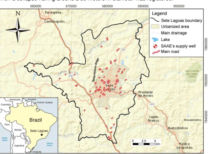
The municipality of Sete Lagoas is located in the state of Minas Gerais, Brazil,
70 km northwest of Belo Horizonte, the state capital. This region has a population
greater than 200,000 over an area of 538 km
2(IBGE 2010). The urban development
was more intense in the northern and northeastern sectors, in comparison to the
initial settlement (Fig. 1). There is a considerable industrial activity located mainly
along the main federal highway, which is a corridor of significant growth. Rapid urban
development has not always been guided by planning, especially in relation to
environmental and geotechnical issues, reflected by 17 documented occurrences of
subsidence or/and collapse since 1988 (Peñaranda J and Cordeiro A.
Hydrogeologists, Servmar Environmental & Engineering, unpublished data, 2013).
The majority of these occurrences are clustered in the central portion of the
urbanized area, which the most important event happened in 1988 (Silva 1988),
when a collapse having around a 20 meters in diameter was registered.
Fig. 1.
Location map of Sete Lagoas, in UTM coordinates, showing the urbanized area limits
Doctoral Thesis 5 Galvão, P.H.F.
Geologically, the area is located in the São Francisco Craton, where
Neoproterozoic carbonate argillo-arenaceous sediments are emplaced giving origin
to the Bambuí Group (Branco and Costa 1961, Oliveira 1967, Schöll and Fogaça
1973, Dardene 1978, Schobbenhaus 1984, Ribeiro et al. 2003, Tuller et al. 2010).
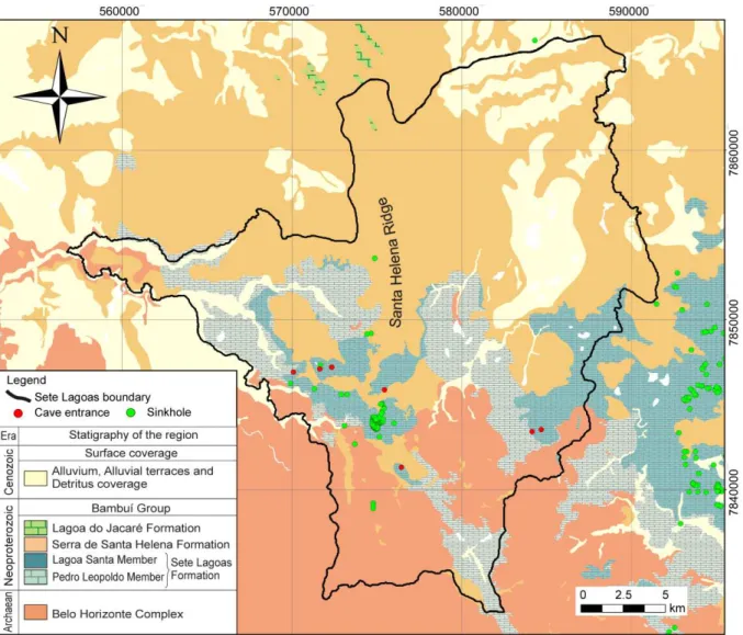
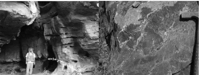
The statigraphy of the region can be seen in the Fig. 2.
The Archaean basement is represented by the Belo Horizonte Complex, which
is generally characterized by a set of gneissic rocks and migmatite zones, with
polymetamorphic features, belonging to the geotectonic unit corresponding to the
São Francisco Craton (Ribeiro et al. 2003). Epigenic and igneous
metamorphic/migmatite rocks with plutonic features mark this occurrence. Mafic
intrusions may also occur, which preferentially fills in the fracture planes. The
contacts between different lithotypes are generally transitional, mainly between
gneiss, migmatites and/or granitoids. The granitoids are light gray to white, with
granulation varying from gross to medium, sometimes with sparse porphyroblasts of
tabular feldspars, xenoliths from other rocks or restites from partial fusion (Tuller et
al. 2010). This complex was intensely affected by basic injections, provoking the
appearance of a group of basic rock dikes (Ribeiro et al. 2003).
Doctoral Thesis 6 Galvão, P.H.F.
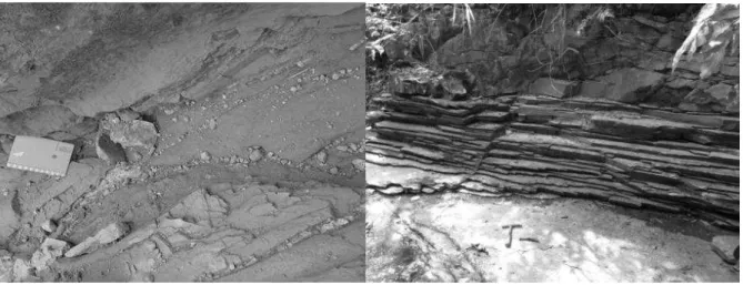
The Bambuí Group is covered by the Cenozoic unconsolidated sediments,
divided into (1) detritus coverage, (2) alluvial terraces, and (3) alluvium (Ribeiro et al.
2003). The detritus coverage is composed of sediments with a predominant red color,
sand to silt with varying levels of gravel, which occur indistinctly on all units, but
mainly over the Serra de Santa Helena Formation. The alluvial terraces occur along
drainages and are mainly constituted of semi-consolidated sand to silt material, with
whitish to yellowish and reddish color. The alluvium occurs along the meanders of the
large watercourses. They are composed of fine to coarse sand, with discontinuous
amounts of quartz pebbles, siltstone and sandstone (Tuller et al. 2010).
Geomorphologically, the area is in a karst setting, which provides the presence
of lakes (located mainly in the central area), caves, sinkholes, and closed drainage
basins (Pessoa 1996, Ribeiro et al. 2003, Tuller et al. 2010). Areas that have denser
drainage are related to the Santa Helena Ridge foothills in the center, basement
outcrops in the south, and metasediments in the north. The elevation of the area
ranges from around 750 to 1000 m, declining from southwest to northeast, where the
highest elevations are located in the Santa Helena Ridge (Fig. 2).
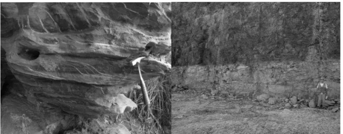
Regarding the hydrogeology, the Sete Lagoas karst aquifer consists of
Neoproterozoic limestones, which the groundwater is predominantly classified as a
calcium-bicarbonate type, with pH values between 6.5 and 7.5, being slightly basic.
Regarding the electrical conductivity, this groundwater has an average of 333
μmhos/cm,
combining with the high levels of dissolved salts (calcium and
bicarbonate). This water, stored in karst conduits, offers good quality for human
consumption, only presenting a light level of water hardness, sometimes causing an
unpleasant taste and problems of encrustation in pipes with smaller diameter
(Pessoa 1996). These limestones dip and become thicker and completely covered by
competent rocks from the Serra de Santa Helena Formation to the northeast,
considered as the local aquiclude. The Belo Horizonte basement works as a fissure
aquifer, where the groundwater is stored in the fractures/faults, which is an
alternative source of groundwater for the municipality.
Doctoral Thesis 7 Galvão, P.H.F.
company has more than 100 public wells located especially in the urbanized area,
where it is possible to obtain the highest discharge rates (Fig. 1).
The mean total monthly precipitation is 106 mm, while the total annual is 1271.8
mm. The rainy season occurs from October to March, with total rainfall of 1132 mm,
accounting for 89% of annual precipitation. The period with less precipitation occurs
from April to September, with 139 mm. The average annual temperature is 20.9 ºC,
with July having the lowest monthly mean value (17.5 °C), and February the highest
one (22.9 °C). The annual variation is around 5°C. According to Pessoa (1996), the
water balance in Sete Lagoas is divided, monthly, in: (1) water excess from January
to March; (2) water deficit from April to September; and (3) water replacement
between October and December, the period of recharging.
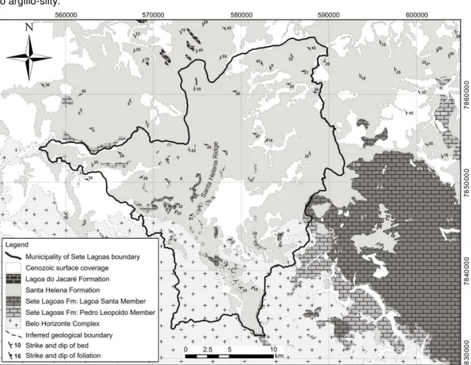
Fig. 2.
Geologic map and the stratigraphic column showing the lithologies found in the study
Doctoral Thesis 8 Galvão, P.H.F.
REFERENCES
Branco Jr, Costa MT (1961) Belo Horizonte-Brasilia roadmap tour. In: Brazilian Congress of Geology, Brasilia. Radioactive Research Institute, Federal University of Minas Gerais (UFMG), Publication 15, Belo Horizonte, p 25.
CECAV (2009) Centro Nacional de Pesquisa e Conservação de Cavernas [National Center for Research and Conservation of Cave]. Available:
http://www.icmbio.gov.br/cecav/downloads
Accessed on March 2014.
Dardenne MA (1978) Synthesis on the stratigraphy of Bambuí Group in Central Brazil. In: Brazilian Congress of Geology, 30, Recife. Annals Recife: Brazilian Society of Geology, 1978 v.2, p.597-610.
Grossi Sad JH, Chiodi Filho C, Chiodi DK (1998) Overview of slates at Minas Gerais State, Brazil. Belo Horizonte: COMIG. CD- ROM.
IBGE - Brazilian Institute of Geography and Statistics (2010). Basic Municipal Information. Avaliable:
http://www.ibge.gov.br/cidadesat/topwindow.htm?1
Accessed on March 2014.Oliveira LM (1997) The management of urban geological risks in karst areas. Undergraduate thesis. Pontifícia Universidade Católica do Paraná (PUC-PR). 46 p.
Pessoa P (1996) Hydrogeological characterization of the region of Sete Lagoas - MG: Potentials and Risks. Master Thesis. Department of Geosciences, University of São Paulo. São Paulo
Ribeiro JH, Tuller MP, Danderfer Filho A (2003) Geological mapping of the region of Sete Lagoas, Pedro Leopoldo, Matozinhos, Lagoa Santa, Vespasiano, Capim Branco, Prudente de Morais, Confins and Funilândia, Minas Gerais State, Brazil (scale 1:50,000). 2nd edn. Belo Horizonte. 54 p.
Schobbenhaus C (1984) Geology of Brazil. National Department of Mineral Production, p 275-277 Schöll WU, Fogaça ACC (1973) Stratigraphy of the Espinhaço in the Diamantina region. In:
Symposium on Geology of Minas Gerais State, Brazil, 1. Acts. Belo Horizonte: Brazilian Geology Society p 55-73 [Bulletin. 1].
Silva AB (1988) Soil subsidence in the city of Sete Lagoas, Minas Gerais State, Brazil. Brazilian Groundwater Journal, n.12
Doctoral Thesis 9 Galvão, P.H.F.
CHAPTER 3: MATERIALS AND METHODS
To achieve the objectives of the thesis, several different methods were utilized
and developed. For better understanding, these methodologies will be separated by
geological and hydrogeological approaches. For geological issues, geologic
mapping, aerial photography interpretation, lithologic well profiles, and optical well log
analysis were made. For hydrogeological issues, pumping tests were run, and water
table measurements were made. Groundwater samples, superficial water and
rainwater were collected for stable isotopes analysis and just groundwater samples
were used for chemical analysis of major ions. These sets of data were integrated to
be evaluated analytically and empirically to understand the mechanisms of the water
circulation in the local karst aquifer and its relationships between other geological
formations. These methods are presented sequentially followed by the approach to
data integration.
3.1 Geological approaches
3.1.1 Geologic mapping
Geologic mapping of the Sete Lagoas was carried out in a scale of 1:25,000.
The classification of the sedimentary rocks followed the definitions of Folk (1980) and
the microscopic classification of the carbonate rocks followed the definitions of Folk
(1959) and Dunham (1962). For the metamorphic and igneous rocks, the
classification followed the definitions of Winter (2001). All the data were recorded on
paper topographic maps and converted to digital format. Later, integration of the field
data and the sheet geologic maps Baldim III), Sete Lagoas
(SE.23-Z-C-II), Contagem (SE.23-Z-C-V), and Belo Horizonte (SE.23-Z-C-VI), scale 1:100,000,
was performed. These maps were acquired from the CPRM database, available on:
http://geobank.sa.cprm.gov.br/
.
Aerial photography interpretation (scale 1:40,000, dated 1977) and the SRTM
image (Shuttle Radar Topography Mission), Sheet SE-23-Z-C, acquired from the
EMBRAPA's website (EMBRAPA 2006) were evaluated to define the map view
lithologic contacts (
http://www.relevobr.cnpm.embrapa.br
).
Doctoral Thesis 10 Galvão, P.H.F.
Nacional de Pesquisa e Conservação de Cavernas
], as a GIS file, available on:
http://www.icmbio.gov.br/cecav/downloads
(CECAV 2009).
3.1.2 Subsurface lithologic contact
In order to obtain information on subsurface about lithologic contacts and karst
features, lithologic well profiles were analyzed and optical well logs were run.
For lithologic well profiles, a series of 218 profiles located in the municipalities of
Baldim, Caetanópolis, Capim Branco, Cordisburgo, Esmeralda, Fortuna de Minas,
Funilândia, Inhaúma, Inimutaba, Lagoa Santa, Maravilhas, Matozinhos, Papagaio,
Paraobepa, Pedro Leopoldo, Prudente de Morais, São José da Lapa, and Sete
Lagoas were acquired from the SIAGAS database, at the website:
http://siagasweb.cprm.gov.br/layout/
. In addition, 52 public well profiles located in
Sete Lagoas were analyzed, provided by Water Supply and Sewage Service
database (SAAE) [
SAAE -Serviço de Abastecimento de Água e Esgoto
]. Out of the
270 profiles that were analyzed, the best and the most reliable were chosen.
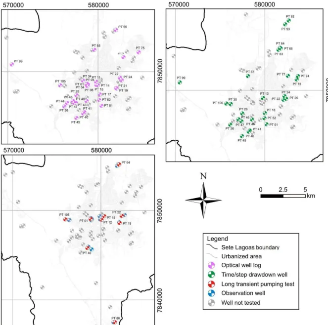
Optical well analysis yielded 30 vertical image profiles collected with R-Cam
1000 Camera (Laval Underground Surveys). In addition to the standard downhole
view, this camera offered a 360 degrees side-view perspective, capable of capturing
a comprehensive survey of water wells. The camera had a maximum depth of 300
meters and was connected to a receiver with monitor that enabled real time imaging.
Therefore, it was possible to register the depths of dissolution zones, fractures and
lithologic contacts. The location of these optical well logs can be seen in the Fig. 3.
3.2 Hydrogeological approaches
3.2.1 Pumping tests
To obtain information about hydrogeological parameters, long transient
pumping tests and drawdown tests were run in the
SAAE’s
public supply wells (Fig.
3). Nine long duration transient pumping tests (48 hours) were made to calculate
well-scale transmissivity and hydraulic conductivity using the Thiem (1906) and Theis
(1935) methods. These tests involved pumping a well at a constant rate and
measuring the drawdown in water level in some observation wells.
Doctoral Thesis 11 Galvão, P.H.F.
a constant rate and measuring the resulting drawdown in water level. In mathematical
terms, the specific capacity is defined as the pumping rate in the well, divided by the
observed decline in hydraulic head in the well, from a time-drawdown test. For the
step-drawdown tests, every discharge value was divided by its respective drawdowns
observed in each step and, then, the mean specific capacity was calculated.
Doctoral Thesis 12 Galvão, P.H.F.
3.2.2 Stable isotopes samples
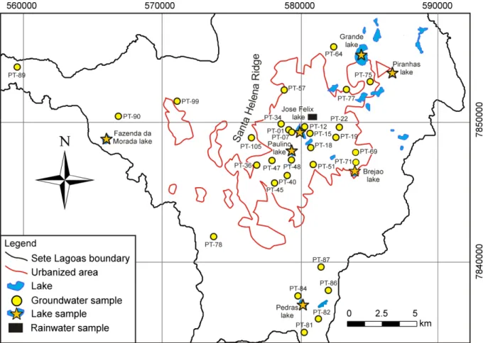
Groundwater samples were taken during August 2011 and November 2012 in
30 SAAE's public supply wells (25 samples from Sete Lagoas karst aquifer and 5
samples from the basement) (Fig. 4). The wells located in the central area are
pumping waters from the conduits in the karst aquifer. These samples were taken
after removing several well volumes of water, using pumps installed in these wells.
This was done to purge the aquifer of stagnant water and to acquire fresh aquifer
samples for analysis. After sampling, physicochemical parameters (pH, temperature -
T, electrical conductivity - EC, and oxidation-reduction potential - ORP) using the HI
9828 portable multiparameter meter were measured.
The surface water samples were collected in June 2013 in seven lakes: Brejão,
Grande, José Felix, Paulino, Pedras, Piranhas, and Fazenda da Morada (Fig. 4). For
this, samples were taken in the center of each lake using a peristaltic pump (brand
Geopump). This method followed the low flow principle, avoiding sediment from the
lake's substrate (Puls and Barcelona 1996).
Eleven cumulative monthly rain isotope samples were also collected
representing a hydrological year, from April 2012 to April 2013 (no samples in July
2012 due to lack of rain). For this, a polypropylene bottle (10 L) with an also
polypropylene funnel connected in that bottle were used and placed in a cooler to
keep the temperature and prevent sunlight penetration. A silicone hose with 6 m long
was also attached on the bottle to balance the pressure and prevent exchanges with
atmospheric air. This method followed the GNIP (Global Network of Isotopes in
Precipitation) instruction, where evaporation and loss of lighter isotopes are negligible
(IAEA/WMO 2004).
The main concern with these samples was to avoid the post-sampling
fractionation. For this, pre-cleaned polypropylene vials (30 ml) were used. These
vials were completely filled with samples, avoiding air bubbles inside and stored in
coolers maintaining the temperature. All samples were analyzed for
18O and
2H at the
Groundwater Research Center (CEPAS) [
CEPAS - Centro de Pesquisas de Águas
Subterrâneas
], Institute of Geosciences, University of São Paulo. The samples were
run on PICARRO L2130i, processed by Laboratory Information Management System
(LIMS) for Lasers software, and were normalized to internal laboratory water
standards that were previously calibrated relative to the Vienna Standard Mean
Ocean Water (VSMOW). The results were expressed as
δ
18O and
δ
2H, where
δ
Doctoral Thesis 13 Galvão, P.H.F.
(‰)
= ((R
sample/R
standard)
−
1) × 1000, where R is D/H,
18O/
16O. The analytical
precisions were
±0.09‰
for
δ
18O and
±0.9‰
for
δ
2H.
After all of these analyzes, the samples were compared with the latest Global
Meteoric Water Line (GMWL) reported by Rozansky (1993), available at IAEA
website:
http://isohis.iaea.org
. This meteoric water line is linearly related by the
equation
2H = 8.17
18O + 11.27, and it is an enhancement to the first meteoric water
line proposed by Craig (1961), related by the equation
2H = 8
18O + 10. This high
correlation coefficient reflects the fact that the oxygen and hydrogen stable isotopes
in water molecules are intimately associated.
3.2.3 Geochemistry analysis
The same supply wells used to collect groundwater samples for isotopic
analysis were also used for geochemistry evaluation (Fig. 4). Samples for major
cations (Na
+, K
+, Ca
2+, Mg
2+), major anions (HCO
-3
, CO
-23, SO
2-4, Cl
-, NO
-3), total
dissolved solids (TDS), and total water hardness (WH) were collected in pre-cleaned
1 L plastic polyethylene bottles, and then stored in coolers at 4°C, according to the
Sampling and Water Samples Preservation Guide (CETESB 1998). For some
analyzes, samples were filtered through a 0.45
μm
filter, while for major cations were
acidified with nitric acid to a pH of less than 2. All these samples were analyzed at
the Analytical Solution Company's laboratory, in São Paulo.
3.3 Georeferencing data and software
All the information was entered in a GIS database and georeferenced in ArcGIS
10.1 software. The coordinate system was the Universal Transverse Mercator (UTM)
projection, Zone 23, datum SAD 69, with units in meters.
Doctoral Thesis 14 Galvão, P.H.F.
To address areas with low data, and to help understand the spatial distribution
of subsurface lithological contacts, as well as to understand the spatial concentration
of some parameters, such as major ions or potentiometric surface, kriging
interpolations of the data were carried out in Surfer 8 software, drawing isopleths
maps. After that, these maps were visually improved in CorelDraw X3 software.
For geochemical samples, all the measurements were checked for accuracy by
calculating the mass balance, and then the water types were classified using the
Piper's diagram of water (Piper 1944) at the AquaChem 4.0 software. For saturation
index of calcite and dolomite calculations, PHREEQCI software was used.
Fig. 4.
Location map of sampling points: groundwater in supply wells (yellow dots), rainwater
Doctoral Thesis 15 Galvão, P.H.F.
REFERENCES
CECAV (2009) Centro Nacional de Pesquisa e Conservação de Cavernas [National Center for Research and Conservation of Cave]. Available:
http://www.icmbio.gov.br/cecav/downloads
Accessed on March 2014.
CETESB (1998) Sampling and Water Samples Preservation Guide. São Paulo, 150 p.
Craig H (1961) Standard for reporting concentration of deuterium and oxygen-18 in natural waters. Science 133, 1702–1703.
Dunham R J (1962) Classification of carbonate rocks according to depositional texture. In: W.E.HAM (ed): Classification of carbonate rocks. Am. Assoc. Petrol. Geol., Mem.1, Tulsa, Oklahoma, p. 108-121.
EMBRAPA (2006) Empresa Brasileira de Pesquisa Agropecuária [Brazilian Agricultural Research Corporation]. Available: http://www.relevobr.cnpm.embrapa.br/download/mg/mg.htm. Accessed on March 2013.
Folk RL (1959) Practical petrographic classification of limestones: American Association of Petroleum, Geologists Bulletin, v. 43, p 1-38
Folk RL (1980) Petrology of Sedimentary Rocks. Hemphill Publishing, Austin, TX, 184p.
IAEA/WHO (2004) Global Network of Isotopes in Precipitation. The GNIP Database. Available at: http://isohis.iaea.org.
Piper AM (1944) A graphical procedure in the geochemical interpretation of water-analysis. Transactions American Geophysical union. v. 25, p. 914-928.
Puls RW, Barcelona MJ (1996) Low flow (minimal drawndown) groundwater sampling procedures. United States Environmental Protection Agency, Office of Research and Development, Office of Solid Waste and Emergency Response, EPA/540/S-95/504, April, 12p.
Rozanski K, Araguás-Araguás L, Gonfiantini R (1993) Isotopic patters in modern global precipitation, in Climate Change in Continental Isotopic Records, Geophys. Monogr. Ser., 78, ed. by P.K. Swart, et al, pp. 1-36, AGU, Washington, DC.
Theis CV (1935) The relation between the lowering of the piezometric surface and the rate and duration of discharge of a well using groundwater storage. Transactions of the American Geophysical Union. v. 16, pp.519-524.
Thiem G (1906) Hydrologische Methoden; Gebhardt, Leipzig.
Doctoral Thesis 16 Galvão, P.H.F.
CHAPTER 4: KARST HYDROGEOLOGY: ORIGINS AND CONCEPTS
The term "karst", meaning stony ground, originates in the Dinaric Plateau in the
Balkans region of Eastern Europe. This is also where the field of karst science began
(Van Beynen 2011). Jovan
Cvijić
(1865-1927) helped lay down the foundation for the
modern understanding of geomorphic processes in the late nineteenth century,
where the karst science has expanded to include other types of karst, such as relict,
paleokarst, fluviokarst, thermokarst, etc. (Ford and Williams 2007). Now in the
twenty-first century, the science of karst has greatly advanced, incorporating an
improved understanding of karst environments, their fragility, and their value to
human development.
Rocks types potentially containing karst cover about 20% of the
Earth’s
land
surface, especially those developed in carbonate rocks, such as limestone, dolomite,
or gypsum (Fig. 5), where 20-25% of the global population depends largely, or
entirely, on groundwater obtained from them (Ford and Williams 2007). In Brazil, it is
estimated that between 5 - 7% of the total surface of the country is composed by
karst rocks (Karmann 1994), with the most extensive karst regions occurring in
central Brazil, developed on Proterozoic and Lower Cambriam limestones and
dolomites (Auler and Farrant 1996). Karst aquifers are extremely heterogeneous with
a distribution of permeability that spans many orders of magnitude. They often
contain open conduit flowpaths with hydraulic characteristics more like surface
streams than groundwater (White 2003).
Doctoral Thesis 17 Galvão, P.H.F.
Fig. 5.
Global distribution of major outcrops of carbonate rocks, where the black areas are
pure carbonates and the grey areas are impure carbonates (from Ford and Williams 2007).
The resulting karst terrain tends to have high numbers of caves and sinkholes.
4.1 The origin of karst
Karst is commonly considered as the result of the solution process of carbonate
rocks, named
“karstification”.
It occurs by chemical and, sometimes, mechanical
action of water in a region generally of limestone, dolomite, or gypsum bedrock
(Karamouz et al. 2011). The chemical composition of groundwater from these
bedrocks is usually dominated by products from dissolution of carbonate minerals
including calcite, aragonite and dolomite. The carbonate solution occurs because the
water is acidic when it contains dissolved CO
2, according to the following
stoichiometric equations (Goldscheider and Drew 2007):
CO
2+ H
2O ↔ H
2CO
3(1)
H
2CO
3↔ HCO
−3+ H
+(2)
CaCO
3↔
Ca
2++ CO
32−(3)
CO
32−+ H
+↔
HCO
-3(4)
Doctoral Thesis 18 Galvão, P.H.F.
carbonic acid that is available and delivers protons (equation 2). Equations 1 - 4 can
be summarized by equation 5:
2H
2O + CaCO
3+ CO
2↔ H
2O + Ca
2++ 2HCO
-3(5)
Because the concentration of dissolved CO
2is driven by both the temperature
and the CO
2partial pressure of the atmosphere related to (ground) water, climate is
generally considered as driving karst processes (Smith and Atkinson 1976,
Bakalowicz 1992). Presently, and for late geologic time, CO
2was only abundant in
the subsurface where it was produced either in soils by biological activity, or at depth
by geological processes. Consequently, karst develops mainly with groundwater
solution of the carbonate rocks.
In fact, the solution of carbonate rocks proceeds only if groundwater flows,
which export the products of dissolution creating underground voids. These voids
progressively organize into a hierarchical structure (the conduit system or karst
network) in the vadose and the phreatic zone. In it, pipe flow conditions prevail, either
under pressure or at atmospheric pressure. Therefore, groundwater flow determines
the hydrogeological structure of karst media, which in return creates an important
feedback effect modifying the flow conditions (White 2003). The orientation and
extension of the flow system and conduit network may change with time, where
conduits may collapse, or be filled with sediments, or saturated conduits may
transform into unsaturated conduits, or vice-versa (Goldscheider and Drew 2007).
For this, karst develops only if the following conditions occur: (1) the possibility
of dissolving carbonate rock, i.e. the existence of a solvent; and (2) a groundwater
flow, determined by a hydraulic gradient and geological discontinuities, such as joints
and bedding planes, folds, or faults/fractures. These conditions result in aquifers in
which there may be unexpected groundwater flow paths and drainage outlet points,
which cannot be predicted on the basis of the present topographic and hydrologic
setting (White 2003, Goldscheider and Drew 2007).
4.2 Features and controls on the development of karst system
Doctoral Thesis 19 Galvão, P.H.F.
stratigraphic, and lithologic factors. These elements are divided into three groups: (1)
the epigenetic forms of absorption, where the infiltration of water in karst carves the
karst morphology; (2) the hypogenic forms, where the water circulates through
underground caves and other underground conduits; and (3) where the hypogenic
circulation returns to normal epigenetic way through surges. All karst system, in local
or regional scale, could have these three types of karst forms characterizing the
"hydrogeological model", with recharge, water circulation (and its heterogeneities)
and discharge area (White 2003).
Király (2002) pointed out that groundwater flow depends on hydraulic
parameters and on boundary conditions and, consequently, that other factor, such as
geology, geomorphology, and climate, exert their influence on groundwater
movement solely through hydraulic parameter fields and boundary conditions. These
essential components inside of a karst aquifer flow system will be discussed as
following.
4.2.1 Recharge of karst aquifer (input control)
A karst aquifer can be envisaged as an open system with a boundary defined
by the catchment limits and with input, throughput and output flows, mechanisms and
controls (Ford and Williams 2007). In the simplest case, there are different categories
for karst aquifer recharge. If the karst area recharges itself, it is called autogenic
recharge. Allogenic recharge occurs when the adjacent non-karst areas recharge the
karst aquifer (Goldscheider and Drew 2007).
Whereas autogenic recharge is often quite diffuse, down many fissures across
the karst outcrop, allogenic recharge normally occurs as concentrated point-inputs of
sinking streams. Both the water chemistry and the recharge volume per unit area are
different in these two styles of recharge, with considerable consequences for the
scale and distribution of the development of secondary permeability (Ford and
Williams 2007).
4.2.2 Hydraulic parameters (throughput control)
4.2.2.1 Permeability of karst aquifer
Doctoral Thesis 20 Galvão, P.H.F.
has been discussed in terms of the "triple permeability" model (White 2003),
consisting of: (1) matrix permeability of the bedrock itself (or primary porosity); (2)
fracture permeability (or secondary porosity); and (3) conduit permeability (or tertiary
porosity).
The matrix permeability of many Paleozoic limestones and dolomites is very low
and can often be ignored. Mezosoic limestones, such as those of Florida and the
Caribbean islands may have very high matrix permeabilities. Fracture permeability
requires two parameters: the fracture aperture and the fracture spacing. Both are
statistical and have a range of values within the same aquifer. Fracture permeability
is modified by solution so that fracture apertures range from tens or hundreds of
micrometers in unmodified limestone up to 10 millimeters. The latter is the aperture at
which non-linear effects begin to appear in the flow field and marks a useful
boundary between large fractures and very small conduits. Conduits can range in
size from 10 mm to tens (sometimes hundreds) of meters. Hydrologically, they
behave much as storm drains. In map view, conduits take on many different patterns
depending on local geology and various characteristics of the flow field itself. To
understand the dynamics of a karst aquifer, then, it is necessary to understand the
rate of recharge into the various components of the permeability and the exchange of
water between these components (White 2003, Ford and Williams 2007).
Because of this triple permeability, karst limestones can lead to well-known
permeability scale effects, which are generally defined as continual increases in
permeability magnitude from small- to regional-scale estimates, which is probably
caused by fractures on the small-scale, and that the largest permeabilities on the
regional-scale were caused by karstic conduits (Ratz 1967, Király 1975, Maclay and
Land 1988, Halihan et al. 1999). According to Halihan et al. (2000), this increment in
permeability can reach nine orders of magnitude variability.
4.2.2.2 Transmissivity and hydraulic conductivity
Doctoral Thesis 21 Galvão, P.H.F.
same time, the hydraulic conductivity has no real physical meaning in the case of
conduit and channel flow; it is proportionality constant in
Darcy’s
law, which was
derived for intergranular porous media, and has the dimension of velocity. Although
the hydraulic conductivity has been used to calculate flow in all aquifer types, it
should be noted that in karst aquifers it represents a lumped parameter, which
describes properties of an
“equivalent
porous media
”.
In other words, the hydraulic
response of all porosity types, including conduits and karst channels, is described
with one parameter: an equivalent hydraulic conductivity (Goldscheider and Drew
2007).
4.2.2.3 Groundwater velocity
Because of widely varying hydraulic conductivity and effective porosity of karst
carbonates, even within the same aquifer system, the groundwater velocity in karst
can vary over many orders of magnitude. One should therefore be very careful when
making a (surprisingly common) statement such as
“groundwater
velocity in karst is
generally very
high”
(Goldscheider and Drew 2007). Although this may be true for
turbulent flow taking place in karst conduits, a disproportionably larger volume of any
karst aquifer
“experiences”
relatively low groundwater velocities (laminar flow)
through small fissures and rock matrix.
It is interesting that, based on 281 dye tracing tests, the most frequent velocity
(14% of all cases) in the classic Dinaric karst of Herzegovina, as reported by
Milanovic (1979), is quite similar: between 864 and 1728 m/d. 25% of the results
show groundwater velocity greater than 2655 m/d in West Virginia, and greater than
5184 m/d in Herzegovina.
Doctoral Thesis 22 Galvão, P.H.F.
4.2.2.4 Groundwater flow
Flow through fractures
Fracture aperture and thickness are two parameters used most often in various
single-fracture flow equations, while spacing between the fractures and fracture
orientation is used when calculating flow through a set of fractures. However, these
actual physical characteristics are not easily and meaningfully translated into
equations attempting to describe flow at a realistic field scale (Goldscheider and
Drew 2007):
1) Fracture aperture is not constant and there are voids and very narrow or
contact areas called asperities. Various experimental studies have shown that the
actual flow in a fracture is channeled through narrow, conduit-like tortuous paths and
cannot be simply represented by the flow between two parallel plates separated by
the
“mean”
aperture (Cacas 1989);
2) Because of stress release, the aperture measure at outcrops or in accessible
cave passages is not the same as an in-situ aperture. Aperture measured on drill
cores and in borings is also not a true one
–
the drilling process commonly causes
bedrock adjacent to fractures to break out thereby increasing the apparent widths of
fracture openings as viewed on borehole-wall images (Williams et al. 2001);
3) Fractures have limited length and width, which can also vary between
individual fractures in the same fracture set. Spacing between individual fractures in
the same set can also vary. Since all these variations take place in the
three-dimensional space, they cannot be directly observed, except through continuous
coring or logging of multiple closely spaced boreholes, which is the main cost-limiting
factor (Williams et al. 2001).
Flow through conduits and channels
Flow through conduits is generally described by the well-known Bernoulli
equation for real viscous fluids. The total energy surface (E) of flow can only
decrease from the upgradient cross section towards the downgradient cross section
of the same flow tube (conduit) due to energy losses. On the other hand, the
piezometric surface (H) can go
“up”
and
“down”
along the same flow tube depending
on the cross sectional area. The total energy surface, which includes the flow velocity
component (
αv
2/2g
), can be directly measured only by the Pitot device whose
Doctoral Thesis 23 Galvão, P.H.F.
Monitoring wells and piezometers, on the other hand, only record the
piezometric pressure (hydraulic head), which does not include the flow velocity
component. It is therefore conceivable that two piezometers in or near the same karst
conduit with rapid flow may not provide useful information for calculation of the real
flow velocity and flow rate between them, and may even falsely indicate the opposite
flow direction. There are additional complicating factors when attempting to calculate
flow through natural karst conduits using the pipe approach: (1) flow through the
same conduit may be both under the pressure and with the free surface; (2) since
conduit walls are more or less irregular
(“rough”),
the related coefficient of roughness
has to be estimated and inserted into the general flow equation; (3) conduit cross
section may vary significantly over short distances; and (4) the flow may be both
laminar and turbulent in the same conduit, depending on the flow velocity,
cross-sectional area and wall roughness. The irregularities that cause turbulent flow are
mathematically described through the Reynolds number and the friction factor.
4.2.3 Discharge of karst aquifer (output control)
Most of the largest springs in the world are karst springs (Ford and Williams
2007). They represent the termination of underground river systems and mark the
point at which surface fluvial processes become dominant. The vertical position of the
spring controls the elevation of the water table at the output of the aquifer, whereas
the hydraulic conductivity and throughput discharge determine the slope of the water
table upstream and its variation under different discharge conditions.
Doctoral Thesis 24 Galvão, P.H.F.
4.3 Karst landform
Karst landscapes form in areas with carbonate bedrock subjected to slow
dissolution processes (Fleury 2009). These processes typically result in the formation
of visible surface and subsurface features, including sinkholes, caves, and springs,
where the water is the main agent of landscape altercation (Palmer 2007).
Subsequently, the basic understanding of the most common karst landforms will be
discussed.
4.3.1 Sinkholes (Dolines)
Sinkholes, or dolines, are an extremely common type of karst landform, created
by the subsidence of soils and rock at or near the land surface into empty space
below (Fleury 2009). They are often located in areas where soluble rock is near the
surface, either completely exposed or beneath a layer of topsoil. Sinkhole
development can be triggered by any mechanism that increases the head differential
between the artesian water in the limestone and the perched water in the surface soil
(Beck 1986), resulting in depressions with a shape of bowls or funnels.
In order to form a sinkhole, three requirements are needed (Fleury 2009): (1) a
drainage path for the surface water runoff to follow; (2) a zone of bedrock modified by
solution located at or near the surface; and (3) a covering of soil or some other
material making up the land surface.
With some exceptions, sinkholes are generally not large landforms. However,
they are important to understand in the context of karst systems because they act as
recharge routes for the aquifer below. The fact that surface water receives no natural
filtering when entering a karst aquifer via sinkhole means that contaminants on the
surface are easily carried into the groundwater (White 1988).
4.3.2 Caves
Doctoral Thesis 25 Galvão, P.H.F.
conditions are fulfilled, and active conduits normally are located close to the valley
bottoms. In mountain ranges, it can be assumed that uplift is more or less
compensated for by the entrenchment of valleys, therefore new conduits have to form
each time the valley floor is entrenched further, previous (higher-level) conduits
become only temporarily active, and later are eventually permanently abandoned by
the water. Most of the caves explored by cavers are part of those dry (fossil)
systems. This simple model may be more complex if, for any reason, the base level
was raised at any time in the past (Audra et al. 2004).
4.3.3 Springs
Springs are formed at the spots where karst waters emerge from the local
underground drainage system. They can be found on the surface or in caves and are
often used as sources of drinking water and as recreation areas (Fleury 2009). Their
formation is a direct result of carbonate rock dissolution, creating large conduits and
caves that can then channel groundwater up to the land surface. Springs can serve
as hydrogeological trend indicators and are very stable in terms of water quality,
temperature and flow, though even short-term variation in rainfall can be reflected by
a spring's flow (Field 2002).
4.3.4 Poljes
Poljes - the largest karst hollows - are wide, closed depressions with flat floors,
which are often adjacent to steep enclosing walls. They require extremely thick and
geographically extensive carbonate bedrock to form at all. Poljes have their own
internal drainage systems and often have complex hydrogeological characteristics,
including shallows holes and disappearing streams (Field 2002).
4.3.5 Karst valleys
Doctoral Thesis 26 Galvão, P.H.F.