Bali, Indonesia, 25-29 April 2010
New Geothermal Prospect in North-Eastern Morocco
Abdelkrim Rimi1, Antonio Correia2, Julio Carneiro 2, Massimo Verdoya3, Yassine Zarhloule 4, Francis Lucazeau 5, Mimoun Boughriba4, Alae Eddine Barkaoui 4
1
Institut Scientifique, Laboratoire de Physique du Globe, B.P. 703, Avenue Ibn Battouta, 10106 Rabat, Morocco email : [email protected] , [email protected]
2 Centro de Geofísica de Évora - Universidade de Évora, Rua Romão Ramalho 59, 7000-671 Évora, Portugal 3
Dipartimento per lo Studio del Territorio e delle sue Risorse, Università di Genova, Viale Benedetto XV, 5, 16132 Genova, Italy 4
Faculté des Sciences, Lab." Gïtes Mineraux, Hydrogéologie, Environnement" Bd Mohamed VI, BP524, 60000, Oujda, Morocco 5
Institut de Physique du Globe de Paris, Géosciences Marines: (UMR7154), 4 Place Jussieu, Paris
Keywords: geothermal gradient - thermal spring –
geothermometer – geothermal potential - Morocco
ABSTRACT
Geothermal data has been indicating promising potentialities in the north-eastern Morocco. This paper presents new temperature data, recently recorded in water borehole located in the Berkane and Oujda areas. Generally, the observed temperature gradients are rather high. One hole near Berkane, revealed an average geothermal gradient of more than 110 ºC/km at depths greater than 300 m. This result confirms the geothermal gradient estimated in a mining borehole located about 30 km west of the Berkane borehole, in which water temperatures of 96 ºC are reached at a depth of about 700 m. Such a high geothermal gradient, exceeding by far the ones already determined for north-eastern Morocco, could act as a stimulus to programs aimed at the geothermal exploitation of high temperature aquifers.
1. INTRODUCTION
Due to the large number and size of surface thermal manifestations (hot springs, recent volcanism neotectonic activity), north-eastern Morocco is a region that has attracted the attention of geothermal experts since the 1960’s (Facca, 1968, Alsac et al. 1969; Cornet et al. 1974). With the objective of improving the geothermal dataset and gaining a better insight into the geothermal potential of eastern Morocco, an exploratory geothermal survey was conducted in 2007 and 2009; in the region of Oujda (Fig. 1) to log some hydraulic boreholes. In particular, two wells in the region of Berkane show high geothermal gradients and could prove valid for high enthalpy geothermal purposes. This paper is a summary of the results of these recent investigations and discusses the new data in the light of previously collected information in deep and shallow boreholes.
2. GEOLOGICAL BACKGROUND
Eastern Morocco is a system of plains, plateaus and mountain ranges extending on the eastern parts of the Meseta-Atlas and Rif domains. It is represented by the Eastern Middle Atlas that continues through the Guercif basin to Beni Snassen, the valley of Moulouya, the Oujda- Taza corridor, the “Pays des Horsts” and a crustal block without notable alpine deformation, which constitutes the High Plateaus.
The Rif domain, located northwards, belongs to the Betic-Rif belt and is part of the peri-Mediterranean alpine chain. With the Atlas, these morpho-structural zones result from
the superposition of several tectonic, compressive and extensional phases of alpine age.
These phases have occurred since the Late Cretaceous. Most of these zones are ENE-WSW to E-W directed (e.g., “Pays des Horsts”) and NE-SW (Middle Atlas, valley of Moulouya), reflecting part of the alpine geological evolution.
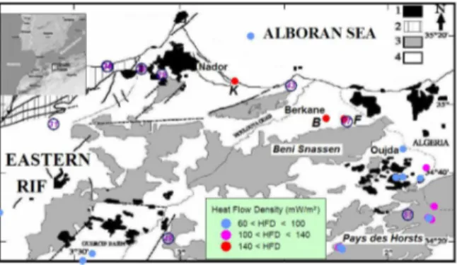
Figure 1: simplified structural sketch map and volcanism in northeastern Morocco, (after Hernandez, 1983; Hervouet, 1985, modified). (1) Miocene and Plio-Quaternary volcanism, (2) Rifian thrust units, (3) foreland (African plate), (4) ‘post nappes’ (sedimentary basins). Heat flow density values are superimposed on this map; numbers in circle represent spring temperature values, K: mining borehole at Kariat Arekman,
B: borehole at Berkane and F: borehole at
Fezouane site.
Regionally, the study area is located east of Gibraltar Arc, which is currently the subject of many geological, geophysical and geodynamical investigations. This has shown that the Gibraltar Arc is characterized by thinned crust and lithosphere, with a fast thickening towards the Betics and the Rif mountain ranges.
Lithospheric thinning under the Alboran Sea and thickening under two ridges of the adjacent Gibraltar Arc is of basic importance for geodynamic models which invoke convective removal and orogenetic collapse, a mantellic delamination and an active subduction (e.g. Royden 1993; Zeck 1996; Platt & Vissers 1989; and Seber et al. 1996; Pasquale et al., 1996). The Alboran Sea continues eastward with the Algerian oceanic crust basin (Ziegler 1992). In eastern Morocco, magmatism developed during the Miocene. A more recent episode consisting of alkaline volcanic activity has taken place from 6 to 0.8 Ma, and
occurred along a NE-trending belt extending from the Trans-Alboran zone to the Middle Atlas domain and to the Anti-Atlas (J. Siroua volcano). Their geochemical signature is similar to that of intra-oceanic island basalts, and suggests the role of an asthenospheric “hot lineament”
(Chalouan et al. 2008). Such interpretation is consistent
with gravimetric and geodetic modeling of the lithosphere (Andeweg and Cloetingh, 2001, Zeyen et al. 2005 and Missenard et al. 2006). This MHL could extend from the Canary Islands to southeast Spain at least.
3. HYDROGEOLOGICAL AND GEOCHEMICAL FEATURES
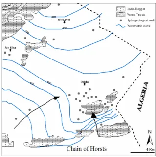
The sedimentary formations in north-eastern Morocco units contain hot reservoirs; in particular Liassic carbonates up to 500 m thick which is the most important aquifer in the region (Fig. 2). The main aquifer is fed into the Horsts area and discharges in the plain of Oujda-Angad, and is composed of carbonate rocks (limestones and colomites) from the lower Cretaceous, the Lias (Fig. 2). The isobaths of Lias vary from a few meters south to 1000 m towards the north. Hydrostratigraphic studies based on geological and hydrogeological data from boreholes show the Liassic carbonate to be the main hydrogeothermal reservoir of the hot springs in the region.
The Liassic reservoir of Eastern Morocco belongs to the Atlas domain, which is characterized by a succession of NE-SW horst and graben of pre-Miocene age and by Plio-quaternary basaltic volcanics, associated with crustal thinning.
This reservoir is at the origin of twenty-four thermal springs whose temperature ranges from 20 to 54 °C and the flow rate can reach 40 l/s at certain points. Salinity varies from 0.28 to 29.6 g/l. Some of these hot springs play an important role in the economy of the area (e.g Fezouane, near Berkane and Hammam Ben Kachour, at Oujda; Zarhloule, 1999; Zarhloule et al., 2001).
Figure 3 shows the Liassic aquifer of the Berkane region. The piezometrical map shows that flow direction is from SE to NW. The recharge area of the confined aquifer is localised in the south, where the Liassic outcrops. In the Fezouane region, the aquifer is artesian.
In the Oujda region, the Liassic limestone forms the main aquifer. Limestone outcrops in Beni Snassen, High-Atlas, Middle-Atlas and the southern part of the basin. The thickness varies from 50 m to 1140 m, and the maximum depth is 1370 m. The groundwater flow is from south to north of basin (Fig. 2). The aquifer temperature and salinity vary from 20 °C to 52 °C and from 130 mg/l to 3000 mg/l, respectively.
According to Zarhloule (1999), the hot temperature and the artesian rise of most of the thermal springs in north-eastern Morocco originate from deep circulation in relation to a system of basement active faults, individuating horsts and grabens, in a recent volcanic area.
Winckel (2002) performed a thorough geochemical analysis of the main hot springs in Morocco and found that eleven of those located along the MHL (Moroccan Hot Line) release CO2 that is partially of deep origin. Recently, Tassi et al. (2006) confirmed that CO2-rich thermal springs with
3 He anomalies are likely related to this hot line. They are mainly distributed along a NE-SW trend from Nador to Taza, and from Fes (Moulay Yacoub) to Oulmes south of the Rif frontal thrust. The contemporary presence of
3
He anomalies and minor recent basalt outcrops indicate that CO2 originates from mantle degassing or deep hydrothermal systems in these thermal discharges
Figure 2: Liassic aquifer in the Oujda region (after Zarhloule et al., 2001).
The geochemical analyses and water classification by means of the diagram of Langelier and Ludwig gave the following hydrogeochemical facies Ca (Mg)-HCO3), NaCl and Ca-Mg (Zarhloule et al., 2005).
The estimated temperatures by silica geothermometers vary between 37 and 85 °C (quartz of Fournier), 23 and 73 °C (quartz of Arnorsson), 54 °C (chalcedony of Fournier) and 57°C (chalcedony of Arnorsson). The measured emergence temperatures vary between 20 and 54 °C. The correction of the water estimated reservoir temperatures by the mixture geothermometer reveals that the temperature in the original reservoir may exceed 110 °C, with a relatively low rate of
4. THERMAL PATTERN AND NEW BOREHOLE THERMAL LOGS
The Gibraltar Arc region is characterized by a radial heat flow pattern with increasing values from the outer ranges towards the center and eastern part of the basin (e.g. Rimi et al., 1998; Fernandez et al., 1998). The most striking geothermal feature is the abnormally hot zone observed east of 4° W and the heat flow increase towards the Algerian basin, where we find volcanic environments and high values typical of a young oceanic lithosphere (Polyak et al., 1996, Rimi et al. 1998).
The analysis of the long wavelength anomalies highlights a heat flux increasing northeastward: 80-110 mW/m2 in the eastern Rif, northeastern Morocco, Alboran Sea (east of the meridian line 4° W), southeastern Spain and northwestern Algeria. In eastern Morocco, the crust is thinned to 15-20 km. The highest heat flow (80-140 mW/m2) and geothermal gradient (35-50 °C/km1) are observed in the north-eastern part of the country (Middle Atlas andEastern Rif), which is characterized by intensive Quaternary volcanism, high residual magnetic anomalies and shallow Curie depths (Rimi et al. 2005).
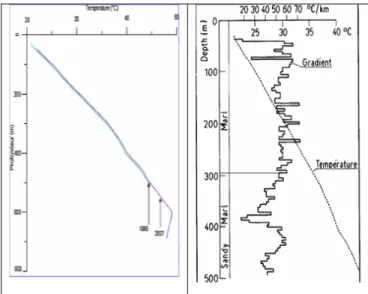
Figure 4 shows a set of temperature data recorded in boreholes of the study area in 1986 (Rimi & Lucazeau, 1987). It shows that the geothermal gradient is generally larger than 30 °C km-1. New thermal logs were performed in 2007 and 2009 at some boreholes (see Fig. 1 for their location). Figures 5-7 depict the temperature depth profiles observed in these boreholes.
Figure 4: Thermal profiles in mining and water boreholes done in Oujda region in 1986 (Rimi & Lucazeau, 1987).
The borehole 2952/12 (Fig. 5) shows a good concordance between the thermal profiles measured after 20 years. At 600 meter depth (corresponding to the lithological change from marl to carbonate), the borehole may be invaded with by a warm water arrival. This results in a sharp decreases and even an inversion of the geothermal gradient.
Figure 5: thermal profile measured in the well 2952/12 (34.4° N, 1.5° W) in 1986 and 2007.
The thermal log of the well located 30 km west of Berkane (Fig. 6) is characterized by an increase of the geothermal gradient at 300 m depth. Notice that the increase of geothermal gradient cannot, to a certain extent, be explained by a change in lithology. In that case, as dolomite should have thermal conductivity higher than clay, the geothermal gradient should decrease. For the moment, no thermal conductivity measurement is available and no heat flow density estimate can be done.
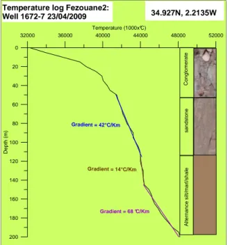
The thermal log of the Fezouane hole (Fig. 7) exhibits a thermal gradient, which apparently varied with depth. The thermal gradient is 42 °C/km in the uppermost 60-120 m section, and then decreases to 14°C/Km between 120 and 150 m, to increase again to about 70 °C/km in the deeper part of the hole. Notice that this log is significantly affected by water flowing within the hole, since it crosses a confined, artesian aquifer.
Figure 6: temperature log of the well 1624-7 in the region of Berkane.
0 20 40 60 80 100 120 140 160 180 200 D e p th ( m ) 32000 36000 40000 44000 48000 52000 Temperature (1000x°C) C o n g lo m e ra te s a n d s to n e A lt e rn a n c e s ilt /m a rl /s h a le Gradient = 68 °C/Km Gradient = 42°C/Km
Temperature log Fezouane2:
Well 1672-7 23/04/2009 34.927N, 2.2135W
Gradient = 14°C/Km
Figure 7: temperature log in the well Fezouane2 in the region of Berkane.
5. DISCUSSION
An earlier study of the French BRGM (Alsac et al. 1969) concluded that north-eastern Morocco does not constitute really a zone with significant geothermal potential. Thereafter, additional studies corroborated this result (Cornet et al. 1974) and underestimated the possibilities of the eastern Rif. Such works cannot be considered conclusive, because they were based on thermal profiles carried out in the first 60 meters of piezometers, which were strongly disturbed by water movement. In addition, they did not take into account any deep geophysical information. More recent investigations claim that the positive geothermal anomaly in the Rif and Eastern Morocco is explainable as a surface manifestation of a deep and wide tectono-magmatic lithospheric process (Rimi et al, 2008). This argument is also supported by the geothermal anomaly observed in a mining borehole drilled in rhyolitic and andesitic series at Kariat Arekman (35.11° N, 2.74° W; Fig. 8). The well, 680 m deep, revealed from 450 m depth salt artesian water (20 to 25 g/l and a flow rate of 1.4-2 l/s) with a temperature of 42 °C at the surface, and more than 90 °C at the bottom (Demble & Lopez, 1977).
Figure 8: observed temperature in the Kariat Arekman hole (Demble & Lopez, 1977). Local estimated heat flow density exceeding 200 mW/m² (Rimi & Lucazeau, 1987).
The new thermal logs recently recorded show possible thermal perturbation due to groundwater effects and/or water flowing within the holes. The acquired data need further processing and careful analyses before their use for geothermal modeling. However, some general conclusions can be drawn from the observed temperatures.
A change in the geothermal gradient does not appear as a result of a change in thermal conductivity. A simple calculation for the Berkane well (Fig. 6) shows that the average geothermal gradient above 300 m is about 29 ºC/km while the geothermal gradient below 300 m is about 127 ºC/km. At a depth of about 470 m the temperature is 50 ºC, and assuming that the same formation reaches depths of 700 m (see lithologic log) this means that an estimated temperature of about 78ºC is attained at about 700 m. If we assume a thermal conductivity of 1.5W/m K for the clay above 300 m and a thermal conductivity of 4.0 W/m K for the dolomites below 300 m we can conclude that the heat flow density along the well is not constant and therefore there is heat trapped at depth below 300 m. The hot water may be recovered essentially in Lias series, for geothermal purposes. However, the problem with the Liasic aquifers is that they are formed by intrinsically compact limestones and dolomites, but which can contain water in fractures and even of karsts systems. The formations may be thus transmissives but not very accumulatives which makes hardly the definition of the thickness of the aquifer, the porosity and the transmissibility. Further investigations must be deserved for a good estimation of the thickness and the porosity of the aquifer which remain key parameters for any attempt of geothermal resource assessment (Muffer & Cataldi, 1978). The borehole of Berkane may not be considered as representative of the geologic, hydrogeologic, and thermal status for a relatively large area, owing probably to complex upward or downward groundwater flow. We remark the difference in thermal gradient between the two boreholes, Berkane (Fig. 6) and Fezouane (Fig. 7), between 150 and 200 m depth.
Notice that we were able to go with the temperature data logger as deep as 900 m in the well; however, at depths of about 500 m and so the temperature data logger has reached its maximum operation limit (50 ºC). Future investigations should then use a temperature data logger that allows to measure temperatures higher than 50ºC.
6. CONCLUSION
High geothermal gradients are observed in NE Morocco In the region of Berkane, temperatures higher than 50 ºC were measured in a water well at depths of about 470 m while this temperature was almost reached at 600 m in another well of Oujda region.
This large geothermal anomalies occurring at depth and this already observed in a mining borehole at Arekman area (Eastern Rif) indicate that medium to high enthalpy uses are
Kariat Arekman borehole (35.11N; 2.74W) s il ty c la y s a n d y c la y m a rl , s a n d m a rl m a rl a n d v o lc a n ic t u ff rh y o li te Qua tern ary Vill afra nchi an Pon to-p lioce ne Mes sini an Pre -Mes sini an Stratigraphy Hydrogeology <--- saturation level Dry residue.: 2 to 16g/l cold and salted water
<--- Confined water cold and salted water
<--- hot and artesian water salt content: 20 to 25g/l PH: 6.5 flow rate: 1 à 2l/s 40 60 80 100 Temperature (°C) 600 500 400 300 200 100 0 D e p th ( m )
Other wells are available in northeastern Morocco for temperature logging, so that the geothermal potential can be estimated. For a valuable assessment of the potential geothermal resources, detailed geophysical surveys have to be carried out in the Oujda- Berkane-Arekman area.
AKNOWLEDGEMENTS
This work was partially supported by the Moroccan-French project "CNRST-CNRS SDU02/07, the Moroccan-Portuguese CNRTS-GRICES project SDT/09 and the Moroccan-Italian MAE project.
REFERENCES
Alsac, C., Cornet, G., Destombes, J. P., Hentinger R., and Lavigne J. : Etude géothermique du Maroc oriental. Rapport inédit, BRGM 69 SGL 264 GTM, Orléans, France, (1969), 97p. 16fig
Andeweg B. and Cloetingh S.: Evidence for an active sinistral shear zone in the western Alboran region. Terra Nova 13, (2001), 44-50.
Chalouan, A., Michard, A., El Kadiri, K., Negro, F., Frizon de Lamotte, D., Saddiqi, O.: The Rif Belt in: Michard A., Chalouan, A., Saddiqi, O. Frizon de Lamotte, D., Eds. Continental evolution: The Geology of Morocco. Springer, (2008), 203-302.
Cornet G., Demange J., Ducroux J., and Lopoukhine M. : Etude géothermique du Rif (Maroc), (1974), BRGM 74 SGN 087 GTH, France, 53p.
Demble, H. and Lopez, N. : Sondage de Kariat Arekman – région de Nador. Etude hydrogéolgique et géothermique préliminaire. Rapport BRPM, (1977) inédit.
Facca, G. : Les possibilités géothermiques du Maroc. Note SEGM (1968), n°. 14, inédit.
Fernàndez M., I. Marzán, A. Correia and E. Ramalho. Heat flow, heat production, and lithospheric thermal regime in the Iberian Peninsula. Tectonophysics, 291, (1998), 29-54.
Missenard, Y., Zeyen, H., Frizon de Lamotte, D., Leturmy P., Petit, C., Sébrier, M. and Saddiqi, O.: Crustal versus asthenospheric origin of the relief of the Atlas Mountains of Morocco. J. Geophys. Res., 111, (2006), B03401, doi:10.1029/2005JB003708
Muffler, L. J. P. and Cataldi, R.: Methods for regional assessment of geothermal resources, Geothermics, 7, (1978), 53-89.
Pasquale V., Verdoya M., and Chiozzi P.: Some geophysical constraints to dynamic processes in the southwestern Mediterranean, Annals of Geophysics, 39(6), (1996), 1185-1200.
Platt J.P. and Vissers R.L.M.: Extensional collapse of thickened continental lithosphere: a working hypothesis for the Alboran Sea and Gibraltar Arc. Geology, 17, (1989), 540-543.
Polyak B. G., Fernandez M., Khutoskoy M. D., Soto J. I., Basov I.A., Comas M.C., Khain V. Y. E, Alonso B., Agapova G.V., Mazurova I.S., Negredo A., Tochitsky V. O. , de La Lind J., Bogdanov N. A., and Banda E. : Heat flow in the Alboran Sea, western Mediterranean, Tectonophysics, 263, (1996), 191-218.
Rimi, A., and Lucazeau, F.: Heat flow density measurements in northern Morocco, J. Afr. Earth Sci.,
6 (6), (1987), 835-843
Rimi, A., Chalouan, A. and Bahi, L.: Heat flow in the southernmost part of the Mediterranean alpin system, the External Rif in Morocco. Tectonophysics, 285, (1998), 135-136.
Rimi, A., Fernandez, M., Manar, A., Matsushima, J., Okubo, Y., Morel, J. L., Winckel, A. and Zeyen, .H: : Geothermal Anomalies and Analysis of Gravity, Fracturing and Magnetic Features in Morocco , World Geothermal Congress Antalya, Turkey, 24-290, (2005).
Rimi, A., Zeyen, H., Zarhloule, Y., Correia, A. Carneiro, J., and Cherkaoui, T.: Structure de la lithosphère à travers la limite des plaques Ibérie - Afrique par modélisation intégrée de température et de densité le long d’un transect N-S à 3°Ouest. Bulletin de l’Institut Scientifique, 30, (2008), 29-37.
Royden L.H. : Evolution of retreating subduction boundaries formed during continental collision. Tectonics, 12, 1993, 629-638.
Seber, D., Barazangi, M., Tadili, B. A., Ramdani, M., Ibenbrahim, A. and Ben Sari, D.: Three-dimensional upper mantle structure beneath the intraplate Atlas and interplate Rif Mountains of Morocco, J. Geophys. Res., 101, (1996), 3125-3138.
Tassi F., O. Vaselli, G., Moratti, L. Piccardi, A., Minissale, R. Poreda, A., Delgado Huertas, A., Bendkik, M., Chenakeb and Tedesco, D. : Fluid geochemistry versus tectonic setting: the case study of Morocco. Geological Society, London, Special Publications; (2006), 262, 131-145.
Winckel, A.: Etablissement d’une typologie des eaux thermals par une approche hydrochimique, isotopique et tectonique. Exemple du Maroc. PhD Thesis, Université de Paris Sud-Orsay, France (2002). Zarhloule, Y. : Potentialités géothermiques du Maroc :
traitement intégré par les températures profondes et indices de surface. Doctorat d'Etat, Fac.Sci. Oujda, Maroc (1999).
Zarhloule, Y., Lahrach, A., Ben Aabidate, L., Bouri, S., Boukdir A., Khattach, D. and Ben Dhia, H.: 2001. La prospection géothermique de surface au Maroc : hydrodynamisme, anomalies géothermiques et indices de surface. Journal African of Earth Sciences, 32, (2001), 851-867.
Zarhloule, Y., Bouri, S., Lahrach, A., Boughriba, M., Elmandour, A., and Ben Dhia, H.: Hydrostratigraphical Study, Geochemistry of Thermal Springs, Shallow and Deep Geothermal Exploration in Morocco: Hydrogeothermal Potentialities. Proceedings, World Geothermal Gongres, Antalya, Turkey, (2005). Zeck H.P.: Betic-Rif orogeny: subduction of Mesozoic
Tethys lithosphere under eastward drifting Iberia, slab detachment shortly before 22 Ma, and subsequent uplifting and extensional tectonics, Tectonophysics,
254, (1996), 1-16.
Zeyen H., Ayarza A., Fernandez M., Rimi A.: Lithospheric structure under the western African-European plate boundary: A transect across the Atlas Mountains and the Gulf of Cadiz. Tectonics, 24, (2005), TC2001, doi: 10.1029/2004TC001639.
Ziegler, P.A.: Europe Cenozoic rift system. Tectonophysics,