Other uses, including reproduction and distribution, or selling or
licensing copies, or posting to personal, institutional or third party
websites are prohibited.
In most cases authors are permitted to post their version of the
article (e.g. in Word or Tex form) to their personal website or
institutional repository. Authors requiring further information
regarding Elsevier’s archiving and manuscript policies are
encouraged to visit:
Environmental performance evaluation of agro-industrial innovations
e
Part 2:
methodological approach for performing vulnerability analysis of watersheds
Maria Cléa Brito de Figueirêdo
a,
*
, Geraldo Stachetti Rodrigues
b
, Armando Caldeira-Pires
c
, Morsyleide de
Freitas Rosa
a
, Fernando Antônio Sousa de Aragão
a
, Vicente de Paulo Pereira Barbosa Vieira
d
,
Francisco Suetônio Bastos Mota
d
aEmbrapa Agroindústria Tropical, Rua Dra Sara Mesquita, 2270-Planalto do Pici, CEP 60.511-110, Fortaleza, Ceará, Brazil
bEmbrapa Labex Europe/Unité Performance des systèmes de culture de plantes pérennes (Cirad PerSyst), TA-B 34/02, Bureau 143, Avenue Agropolis, 34398 Montpellier Cedex.5, France
cUniversidade de Brasília, Campus Universitário Darcy Ribeiro, CEP 70910-900, Brasília, Distrito Federal, Brazil dUniversidade Federal do Ceará Bloco 713, Campus do Pici, CEP 60451-970, Fortaleza, Ceará, Brazil
a r t i c l e
i n f o
Article history:
Received 17 August 2009 Received in revised form 12 March 2010 Accepted 22 April 2010 Available online 21 May 2010
Keywords:
Multi-criteria analysis Innovation
Ambitec-Life Cycle Environmental impact
a b s t r a c t
Environmental vulnerability analysis has been sparsely used in environmental performance evaluation (EPE) of technological innovations. The present paper proposes a methodological approach to carry out vulnerability analysis of watersheds and to integrate this analysis into methods of environmental performance evaluation of agro-industrial innovations. This approach is applied to the Ambitec-Life Cycle method, described in Part 1 (this issue) of this study. The case study of green coconut substrate compared to ripe coconut substrate, also described in Part 1 (this issue), is now presented considering the vulnerability analysis of the watersheds where the life cycle stages of these products occur. The inte-gration of vulnerability analysis in Ambitec-Life Cycle contributes to a better understanding of the environmental aspects of agro-industrial technological innovations with potential to cause significant impacts in watersheds where these innovations are implemented.
Ó2010 Elsevier Ltd. All rights reserved.
1. Introduction
The environmental performance evaluation (EPE) of
agro-indus-trial innovations is an important step in the technological innovation
process. Numerous methods are available to conduct the EPE of
technological innovations. Among these, some speci
fi
cally address
agricultural and agro-industrial innovations, such as the
Ambitec-Agro (Rodrigues et al., 2003) and the Inova-tec (Jesus-Hitzschky,
2007) approaches, routinely applied in product or process
evalua-tion at the Brazilian Agency for Agricultural Research
e
Embrapa. A
more general approach to EPE is offered by life cycle assessment (LCA)
methods such as the Ecoindicator 99 (Goedkoop and Spriensma,
2000), IMPACT 2002
þ
(Jolliet et al., 2003), EPS (Steen, 1999), TRACI
(Bare, 2003) and EDIP 2003 (Potting and Hauschild, 2005).
Each of these methods presents specially appropriated scopes
and sets of selected indicators, but none of them is directly
designed to consider the vulnerability of local environments where
technological innovations are implemented. The use of
vulnera-bility analysis is still in its beginning in the environmental
perfor-mance arena. According to Kværner et al. (Kværner et al., 2006),
vulnerability studies are hardly carried out during project or
technological evaluations, despite their potential to enlighten the
very de
fi
nition of impacts to be considered and the decisions on
appropriate projects or technological alternatives in impact reports.
For example, an agro-industrial product or process that requires
large amounts of water should not be developed or adopted in
a semi-arid region. In such an environment, water scarcity, soil
salinization, and deserti
fi
cation are restraining vulnerability
aspects that impose important qualitative and quantitative
considerations, e.g., how restraining is water availability? At which
level do these resource limitations impede resource extraction for
production and discharge of processing residues?
In fact, vulnerability studies have been developed in the last
decade to support planning decisions in the most varied scopes and
scales such as the vulnerability of regions to climate change
(Metzger et al., 2006), mountain areas to environmental
degrada-tion (Li et al., 2006), aquifers to pesticide and nitrate contaminadegrada-tion
(Barreto, 2006), geosystems to morphological processes (Lima et al.,
* Corresponding author. Tel.:þ55 85 3391 7100; fax:þ55 85 3391 7109.E-mail addresses:[email protected](M.C. Brito de Figueirêdo),stacheti@
cnpma.embrapa.br (G.S. Rodrigues), [email protected] (A. Caldeira-Pires),
[email protected] (M. de Freitas Rosa), [email protected] (F.A.
Sousa de Aragão),[email protected](V. de Paulo Pereira Barbosa Vieira),suetonio@
ufc.br(F.S. Bastos Mota).
Contents lists available at
ScienceDirect
Journal of Cleaner Production
j o u r n a l h o m e p a g e : w w w . e l s e v i e r . c o m / l o c a t e / j c l e p r o
0959-6526/$esee front matterÓ2010 Elsevier Ltd. All rights reserved.
doi:10.1016/j.jclepro.2010.04.013
2000), regions to global change (Schoter et al., 2004; Metzger et al.,
2006), suburban areas to industrial pollution
(Tixier et al., 2005),
watersheds to environmental degradation (Tran et al., 2002;
Zielinski, 2002), reservoirs to eutrophication (Bennion et al., 2005;
Figueirêdo et al., 2007), and ecosystems to environmental
degra-dation (Villa and McLeod, 2002).
As approached in these studies, vulnerability analysis has been
related to speci
fi
c environmental concerns (climate change, erosion,
water pollution, etc.) and applied at different scales (aquifers,
watersheds, geosystems, ecosystems, etc.), denoting a variety of
concepts, applications, and scopes of currently available literature.
The objective of the methodological research detailed in the
present study is to propose an objective, quantitative approach to
allow the analysis of watershed vulnerability and to integrate this
analysis into EPE methods devoted to agro-industrial technological
innovations. In that sense, this approach is applied to the newly
developed Ambitec-Life Cycle, a multi-criteria method that
considers life cycle thinking in the environmental performance
evaluation of agro-industrial innovations (Part 1 (this issue)). The
case study of green coconut substrate (GCS), compared to ripe
coconut substrate (RCS) (Part 1 (this issue)), is now presented
considering the vulnerability analysis of four Brazilian watersheds
where the life cycle stages of these products occur. An analysis is
performed to point out which environmental performance
indi-cators have more potential to cause impacts on these particular
watersheds, considering their environmental vulnerability.
2. Methodological approach to evaluate the environmental
vulnerability of watersheds
2.1. Vulnerability concept and scale
In order to insert vulnerability analysis as a quantitative
procedure in the EPE of agro-industrial innovations, the
vulnera-bility conceptualization advocated by Adger (Adger, 2006) and
Gallopin (Gallopin, 2006) has been adapted, so that environmental
vulnerability is understood as the susceptibility of a watershed to
degradation, evaluated by considering the local environment’s:
-
exposure
to pressures, related to materials and energy
consumption and pollutant emissions. The consumptions and
emissions observed are those commonly associated with
agro-industrial activities, but that can also be inherent to other
activities that have the potential to cause environmental impacts
in the watershed (e.g.: water demand, wastewater and solid
waste generation);
-
sensitivity
to exerted pressures, evaluated by observing the
main physical and biotic environmental characteristics (e.g.:
soil types, climate, biodiversity) that occur in the watershed
and interact with the considered pressures, making the system
more or less vulnerable to such pressures;
-
capacity of response, evaluated by the adoption of conservation
measures by a local society that may enhance the watershed
capability to better respond to the exerted pressures. It is also
evaluated by the awareness and capability of the local society
to understand and act upon the exposure and sensitivity of the
local environment (e.g.: sewage facilities, water storage, and
delimitation of conservation areas).
The scale in a vulnerability study can be delimited in a range of
spatial or socio-economic levels (ecosystem, geosystem, watershed,
neighborhood, territory, etc.) according to the objectives of the
study. However, the watershed is specially suited to vulnerability
studies because human activities and associated technologies can
directly alter a watershed’s water quantity and quality, or change
soil and vegetation characteristics that affect water resources.
2.2. Multi-criteria structure
A literature review on sets of indicators related to
agro-indus-trial environmental issues (Figueirêdo, 2008; Monteiro and
Rodrigues, 2006) revealed that those most frequently relevant in
a watershed context are: biodiversity loss, soil erosion, compaction,
salinization, sodi
fi
cation, acidi
fi
cation, deserti
fi
cation,
agrochemi-cals contamination, solid wastes, water scarcity, and water
pollu-tion. Thus, vulnerability indicators that allowed objective
expression of a watershed exposure, sensitivity and capacity of
response to these issues were chosen for the present study. An
important additional consideration for the selection and
organi-zation of indicators was the availability of reliable data for public
consultation in of
fi
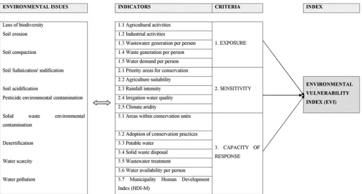
cial databases. The indicators were organized
under the criteria of exposure, sensitivity, and capacity of response.
A hierarchical multi-criteria structure based on the proposed
vulnerability concept is presented in
Fig. 1. The description of each
indicator is presented in
Appendix A.
Because indicator variables are usually represented by different
measurement units, normalization to a common dimensionless
scale is a typical step in order to allow aggregation in criteria and in
a
fi
nal integrated index. The vulnerability scale used ranges from 1
(low vulnerability) to 2 (high vulnerability). The rules used to
perform the appropriate normalization and aggregation steps
necessary for this index development are described in Figueirêdo et
al (Figueirêdo et al., 2009).
2.3. Strategy for considering vulnerability analysis in the EPE of
agro-industrial innovations
According to Malczewski (Malczewski, 1999), the EPE can be
assessed using multi-criteria analysis where a set of environmental
indicators are related to criteria or objectives and these to a
fi
nal
EPE index, that is used to support decisions about technological
innovation adoption. Ambitec-Agro (Monteiro and Rodrigues,
2006), Inova-tec (Jesus-Hitzschky, 2007), and Ambitec-Life Cycle
(Figueirêdo, 2008) are examples of EPE methods that use
multi-criteria schemes to study the possible impacts of agro-industrial
innovations. Although each EPE method based on multi-criteria
analysis has different hierarchical structures connecting indicators,
criteria, and a
fi
nal index, and uses particular rules for
normaliza-tion and aggreganormaliza-tion, they all are based on measurable indicators
that can be weighed by a vulnerability index. This vulnerability
index can in turn function as a correction factor to translate
a watershed susceptibility to studied environmental pressures.
Weighed indicator
i¼
EPE indicator
i*
EVI
(1a)
Weighed indicator
i¼
EPE indicator
i*
EVI
1
(1b)
In Equations
(1a) and (1b),
‘EPE_indicator
i’
is the normalized value
of an indicator
‘i’
in a particular EPE method that can cause relevant
impact at the watershed level;
‘EVI’
is the dimensionless
normal-ized value representing the environmental vulnerability of the
watershed where the EPE of an innovation is being carried out; and
‘Weighed_indicator’
is the new modi
fi
ed value of an EPE indicator
‘i’
that was weighed by the watershed vulnerability index. The use
of equation 1a can result in a score higher than the range used by an
environmental performance multi-criteria method and, in this case,
the maximum original score adopted by the method shall prevail.
3. Application of the proposed strategy to Ambitec-Life Cycle
The strategy proposed to insert vulnerability analysis in the EPE
of innovations has been applied to Ambitec-Life Cycle, the method
presented in Part 1 (this issue) of this study. This method evaluates
the environmental performance of an agro-industrial technological
innovation as compared with a current product or process, using
a set of performance indicators organized in principles, criteria,
and in a total environmental performance index. Ambitec-Life Cycle
considers four life cycle stages of an innovation: (i) production/
extraction of raw materials and resources used by the innovation;
(ii) innovation production process; (iii) innovation utilization; and
(iv)
fi
nal disposal.
The integration of vulnerability analysis within Ambitec-Life
Cycle expands its framework, as presented in
Fig. 3. At the left side
of this
fi
gure, vulnerability analysis was introduced for each stage of
the innovation as well as for its current product or process. The
results of vulnerability analysis are then used in the environmental
performance evaluation of the innovation and of its current product
or process, performed in each of their life cycle stages and in their
total analysis. At the right side of
Fig. 3, a new step was introduced
in Ambitec-Life Cycle original framework (described in Part 1 (this
issue)) to carry out the vulnerability analysis and to integrate the
environmental vulnerability index (EVI) in the procedures of
environmental performance evaluation.
3.1. Case study of EPE of an agro-industrial innovation using the
Ambitec-Life Cycle method expanded with vulnerability analysis
The proposed expanded framework of Ambitec-Life Cycle was
applied to identify the in
fl
uence of the watershed vulnerability in
the performance evaluation of the agro-industrial innovation
‘Green
coconut substrate’
(GCS), as compared to the current product
‘Ripe
coconut substrate’
(RCS). Both substrates act as a physical support to
seedlings and to plant production in soilless cultivation. The life
cycle stages involved in the study of these products were: (i) coconut
husks disposal (stage 1), (ii) substrate production (stage 2), (iii)
substrate use in rose seedling production (stage 3a) and in rose
production (stage 3b), and (iv) substrate
fi
nal disposal in a
com-posting area (stage 4). Part 1 (this issue) of this study presents details
of the environmental performance evaluation of GCS and RCS.
In this case study the values of environmental performance
indicators to each life cycle stage of these products were obtained
in production units located at four different watersheds:
Metro-politana, Parnaíba, Litoral, and Baixo Mundaú (Table 1). All these
watersheds are located in the Brazilian Northeast, a region
Fig. 2.Strategy for integrating the vulnerability analysis in the EPE of agro-industrial
innovations.
Fig. 1.Set of watershed environmental vulnerability indicators, organized in a multi-criteria structure.
M.C. Brito de Figueirêdo et al. / Journal of Cleaner Production 18 (2010) 1376e1385
characterized by semi-arid climate with rainfall concentrated in
few months of the year and a great part of its population presenting
low income and literacy rates.
3.1.1. Vulnerability analysis of watersheds
The results of this analysis are shown in
Table 2. Vulnerability
analysis was performed in these watersheds using available
data-bases as well as minimum and maximum values to quantitative
indicators that are appropriate to the Brazilian environmental
condition, presented in
Appendix B.
The EVI obtained for these watersheds ranged from 1.52 in Baixo
Mundaú to 1.57 in Metropolitana watershed. Although the
varia-tion range was narrow among the watersheds, important
differ-ences in the vulnerability criteria were perceived. For instance,
three of the studied watersheds presented low vulnerability to
exposure (Metropolitana-1.35, Litoral-1.29, and Parnaíba-1.24),
with just Baixo Mundaú achieving a medium exposure (1.48),
mainly explained by the important agricultural sector observed in
this watershed. Sensitivity varied from low (Baixo Mundaú-1.34) to
medium (Litoral-1.59) to high (Metropolitana-1.61 and
Parnaíba-1.68). Higher sensitivity is related to higher rainfall intensity and
climate aridity (especially in Parnaíba). All watersheds presented
low capacity of response and consequently high vulnerability in
this criterion (Metropolitana-1.73, Litoral-1.78, Parnaíba-1.73 and
Baixo Mundaú-1.74), mostly related with modest investments in
conservation units and low water availability.
3.1.2. Integration of vulnerability analysis in the EPE of GCS and RCS
The EVIs of these watersheds were integrated into the
perfor-mance evaluation of GCS and RCS, according to the framework
presented for Ambitec-Life Cycle in
Fig. 3. It is worth to recall that
the performance scale of Ambitec-Life Cycle ranges from 0 (worst
performance) to 100 (best performance).
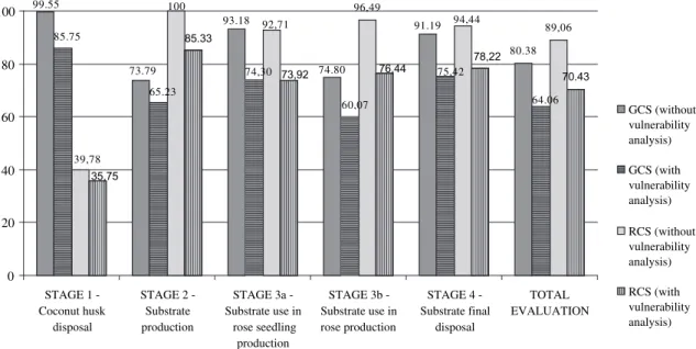
The EPE results of these products obtained by using the
Ambi-tec-Life Cycle without vulnerability analysis (Part 1 (this issue) of
this study) are compared with the EPE results using the expanded
version of this method in
Fig. 4. In the
fi
rst situation, since
vulnerability was not considered, it was as if all watersheds
Fig. 3.Framework of Ambitec-Life Cycle, considering vulnerability analysis.
Table 1
Watersheds related to each life cycle stage of GCS and RCS. TECHNOLOGY STAGE 1-Coconut substrate
disposal
STAGE 2-Substrate production
STAGE 3a- Substrate use in rose seedling production
STAGE 3b - Substrate use in rose production
STAGE 4 - Substratefinal disposal
Table 2
Results of the vulnerability analysis of four Brazilian watersheds.
Environmental
VulnerabilityeMetropolitana
Watershed (State of Ceará)
Environmental VulnerabilityeLitoral
Watershed (State of Ceará)
Environmental VulnerabilityeBaixo
Mundaú Watershed (State of Alagoas)
Environmental VulnerabilityeParnaíba
Watershed (State of Ceará)
Criteria Indicators Weight of Indicators
Weight of criteria
Indicators Criteria EVIa Indicators Criteria EVIa Indicators Criteria EVIa Indicators Criteria EVIa
1. Exposure 1.1 Agriculture activity
0.2 0.33 1.33 1.35 1.57 1.32 1.29 1.55 1.65 1.48 1.52 1.06 1.24 1.55
1.2 Industrial activity 0.2 1.09 1.01 1.00 1.00 1.3 Wastewater
generation per person
0.2 1.48 1.13 1.42 1.19
1.4 Waste generation per person
0.2 1.78 1.97 1.71 1.90
1.5 Water demand per person
0.2 1.06 1.01 1.60 1.06
Total¼ 1
2. Sensibility 2.1 Priority areas for conservation
0.2 0.33 1.47 1.61 1.40 1.59 1.41 1.34 1.52 1.68 2.2 Agriculture
suitability
0.2 1.63 1.58 1.28 1.69
2.3 Rainfall intensity 0.2 1.80 1.80 1.78 1.87 2.4 Irrigation water
quality
0.2 1.54 1.50 1.14 1.61
2.5 Climate aridity 0.2 1.63 1.65 1.12 1.72 Total¼ 1
3. Capacity of Response
3.1 Areas in conservation units
0.14 0.33 1.99 1.73 2.00 1.78 1.99 1.74 1.99 1.73 3.2 Adoption of
conservation practices
0.14 1.78 1.88 1.92 1.89
3.3 Potable water 0.14 1.57 1.58 1.45 1.41 3.4 Solid waste
disposal
0.14 1.65 1.68 1.66 1.58
3.5 Wastewater treatment
0.14 1.80 1.93 1.79 1.86
3.6 Water availability per person
0.14 2.00 2.00 1.99 1.99
3.7 Municipality Human Development Index (HDI-M)
0.14 1.34 1.38 1.40 1.36
Total¼ 1 1
aEVI
¼Environmental Vulnerability Index.
80.38
70.43
93.18
73.79 74.80
91.19 99.55
85.75
64.06 75,42
60,07 74,30
65.23
89,06 96,49
94,44 92,71
100
39,78
78,22 76,44
73,92 85.33
35,75
0
20
40
60
80
100
STAGE 1 -Coconut husk
disposal
STAGE 2 -Substrate production
STAGE 3a -Substrate use in
rose seedling production
STAGE 3b -Substrate use in rose production
STAGE 4 -Substrate final
disposal
TOTAL EVALUATION
GCS (without vulnerability analysis)
GCS (with vulnerability analysis)
RCS (without vulnerability analysis)
RCS (with vulnerability analysis)
Fig. 4.Environmental performance along the life cycle stages of GCS and RCS without and with vulnerability analysis integration.
M.C. Brito de Figueirêdo et al. / Journal of Cleaner Production 18 (2010) 1376e1385
involved in the study presented the lowest vulnerability (equal to
one). When vulnerability analysis was introduced, since the EVI
scores of the involved watersheds were around 1.5, the
environ-mental performance index of both products were reduced, in all
stages of their life cycles and in the total EPE stage.
The total EPE of the studied products performed with
vulnera-bility analysis showed that when all stages are considered, the
performance of GCR was lower than the performance of RCS. This
occurred because the average EVI for GCS, considering the
vulner-ability of the watersheds involved in each one of the GCS life cycle
stages (Table 1), was higher (1.56) than the average EVI obtained for
RCS (1.54). This result corroborated the result obtained by the
evaluation without vulnerability analysis (Part 1), where RCS
showed advantages over GCS.
Analyzing the performance of the studied products at each life
cycle stage, the GCS continued to perform higher than RCS in stages
1 and 3a, and lower in stages 2, 3b and 4, when vulnerability was
considered. To understand which environmental aspects of GCS
have more potential to cause positive and negative impacts in the
studied watersheds, each life cycle stage is analyzed next.
3.1.2.1. Effects of vulnerability analysis in stage 1 (coconut husk
dis-posal).
In stage 1, the vulnerability analysis showed that the EVI of
the Metropolitana watershed, where the green coconut husks were
disposed in a land
fi
ll, is higher than the EVI of Litoral, where ripe
coconut husks were incorporated into agricultural soils. These
vulnerability results reinforce the comparative advantage of using
green instead of ripe husks as raw material for the production of
substrate, since green husks are diverted from land
fi
lls.
The use of green coconut husks implies that there will be no
disposal of this material in land
fi
lls and, consequently, no leachate
generation and lower water levels, fossil fuels and energy
consumption. The generation of leachate, by green coconut husk
anaerobic degradation, has great potential to contribute to water
pollution in the Metropolitana watershed that already presents
medium vulnerability (1.48) to wastewater generation and high
vulnerability (1.80) to wastewater treatment (Table 2). The
consumption of water should also be avoided in the Metropolitana
watershed that presents low water availability per person (2.0).
3.1.2.2. Effects of vulnerability analysis in stage 2 (substrate
production).
In stage 2, GCS performed lower than RCS when
vulnerability was considered, since the EVI of Metropolitana, where
GCS was produced, was higher (1.57) than the EVI of Baixo Mundaú
(1.52), where RCS was produced. Considering that the production of
GCS presented higher consumption of water and higher generation
of solid wastes and ef
fl
uent polluting load than RCS (Part 1), the
potential impact of these aspects in a watershed, such as
Metro-politana, was higher. In this watershed, water availability was
already very low, wastewater treatment and waste facilities were
insuf
fi
cient and waste generation was higher (Table 2).
3.1.2.3. Effects of vulnerability analysis in stages 3 (substrate use) and
4 (substrate disposal).
In stage 3a (substrate use in rose seedling
production), both products were adopted by the same production
unit located in the Parnaíba watershed. Although the performance
of these products was reduced with vulnerability analysis, the
advantage of GCS over RCS was maintained. Despite GCS’
better
performance, it is important to notice that the impact of water
consumption (used in the washing of GCS before rose seeding
production) was signi
fi
cant in Parnaíba which presented high
vulnerability to climate aridity and water availability (Table 2).
Stages 3b (substrate use in rose production) and 4 also occurred in
the same production unit, located in the Parnaíba watershed. The
performance of both products decreased, but the GCS continued to
perform lower than the RCS. Attention should be given to the high
volume of water demanded by GCS and high ef
fl
uent polluting load
generated when irrigation water was drained and the GCS was
washed to reduce its electrical conductivity in rose production. These
environmental aspects have great potential to contribute to water
scarcity and pollution in the Parnaíba watershed, which presented
high vulnerability to water availability and wastewater treatment
(Table 2).
In stage 4, the larger amount of GCS refused after two years of
rose production required larger areas for composting
fi
elds. Care
should be taken in the choice of the composting area to avoid using
good quality agricultural or forested areas. Parnaíba watershed
presented high sensitivity and vulnerability to agriculture
suit-ability and medium sensitivity and vulnersuit-ability to priority areas
for conservation.
3.1.2.4. Overall effects of vulnerability analysis in the EPE of GCS and
RCS.
The integration of vulnerability analysis in the environmental
performance of GCS shows that the environmental performance
indicators that received low scores, related to water consumption
and waste and ef
fl
uent generation, present great potential to
signi
fi
cantly impact the studied watersheds (Metropolitana, Litoral,
and Parnaíba). These watersheds are already vulnerable to the
occurrence of water scarcity events and water pollution, as well as
contamination by inadequate solid waste disposal. Further research
to reduce water consumption, as well as to reduce emission and
reuse ef
fl
uents and wastes generated along GCS life cycle stages,
shall be carried out by R&D teams in order to improve the
inno-vation performance and to minimize its pressure upon natural
resources in the involved watersheds.
Because these substrates can be produced and used in seedling
and plant production all over Brazil, especially in the coastal areas,
vulnerability analyses should be carried out in the other
water-sheds. This action would shed light on which watersheds GCS
would probably cause smaller impacts, before research actions
de
fi
ne new processes and product characteristics that could
improve its environmental performance.
4. Discussion and conclusion
Any attempt to measure vulnerability implies judgments about
which issues to include and which threshold values to adopt. This
fact, however, does not reduce scienti
fi
c debates and attempts to
develop methods for conducting vulnerability analysis, that have
been increasingly used in a range of disciplines, as a tool for
deci-sion making (Adger, 2006). In the environmental area, different
interpretations of this term and measurement methods have been
developed, especially to help prioritization of actions in regions
affected by global change (Metzger et al., 2006; Schoter et al.,
2004), by ecosystem change (Villa and McLeod, 2002), and by
water eutrophication (Bennion et al., 2005; Figueirêdo et al., 2007).
The main bene
fi
ts of adopting the proposed environmental
vulnerability strategy is the knowledge gained about which
envi-ronmental aspects (covered by performance indicators) could most
probably cause signi
fi
cant impact in the natural resources at the
watershed level. Without vulnerability analysis, an EPE method
indicates critical environmental aspects of an organization
manage-ment system, a project, an activity or an innovation, but hardly
correlates these aspects with impacts in a regional scale. This
corre-lation may better support decisions about which aspects to prioritize
in management actions.
EPE methods based on qualitative analysis (e.g., methods based
on descriptive checklists or Battelle Columbus matrices (Canter,
1996) do not bene
fi
t from the proposed strategy, since indicators
team that conducts EPE studies based on such methods, because it
allows a better understanding of the surrounding environment
where innovation can be adopted. The accomplishment of
a vulnerability analysis always attracts the attention of the EPE
team in a research institute to those characteristics of a watershed
that make it more vulnerable and, consequently, facilitate the
shaping of innovations to perceived environmental constraints.
Acknowledgements
The authors would like to thank the Brazilian Agricultural
Research Corporation (Embrapa), for
fi
nancially supporting the
research, and the researchers Adriano Lincoln Albuquerque Mattos
and Renato Carrha Leitão, for revision and important contributions
to this work.
Appendix A. Description of vulnerability indicators.
Indicators Description Calculation procedure 1.1 Agricultural
activities
This indicator evaluates the pressure exerted by agriculture and animal husbandry in a watershed. Agriculture activities represent a pressure factor in a watershed due to deforestation and land clearing, which can lead to biodiversity loss, cause soil degradation (erosion, salinization, and sodification) through inappropriate plowing and irrigation techniques, and can contribute to climate change and environmental contamination by agrochemicals.
Agriculture_activityi¼(agriculture_areai/municipality_areai)*100
Where‘agriculture_areai’is the area (in hectares) devoted to crops, pastures, and silviculture in municipality‘i’of the studied watershed;‘municipality_areai’is the area of municipality‘i’in hectares, and‘agriculture_activityi’, the percentage area of municipality‘i’devoted to agriculture. These data are commonly published at government agriculture agencies and the indicator ranges from 0% (minimum value) to 100% (maximum value).
1.2 Industrial activities
This indicator evaluates the pressure exerted by industry in a watershed. Industrial activities are important pressure factors, due to release of contaminants that can pollute soil, air, and water, as well as cause deforestation, biodiversity losses, and soil degradation (mainly extractive industry).
Industrial_activityi¼employed_peoplei/municipality_areai
Where‘employed_peoplei’means the number of people employed in extractive and transformation industries in municipality‘i’in the studied watershed;
‘municipality_areai’is the area of a municipality‘i’and‘Industrial_activityi’, the number of people employed in these industries by area unit in the watershed. These data are usually researched by government statistic offices.
1.3 Wastewater generation per person
This indicator computes the intensity of wastewater generation in a watershed. This indicator is nearly related to the water quality level in a watershed, since more wastewaters require larger water volumes to dilute pollutants, a critical problem especially in semi-arid regions. Generation of large amounts of wastewaters in a watershed is expected to cause water pollution, especially in regions where there is no appropriate treatment facilities.
Wastewater_generationi¼collected_volumei(m3/year)/population_reachedi(hab)
Where‘collected_volumei’is the total sewage volume collected by year in municipality‘i’in the studied watershed;‘population_reachedi’is the number of people with access to wastewater treatment in municipality‘i’, and
‘Wastewater_generationi’is the wastewater volume generated by person in municipality‘i’.
1.4 Solid waste generation per person
This indicator evaluates the intensity of solid waste generation in a watershed. Even when correctly disposed (landfills or incinerators), solid wastes can emit odors, global warming gases, and effluents rich in organic and inorganic pollutants. Solid waste generation leads to soil and water pollution in a watershed, especially in regions where appropriate solid waste treatment facilities are scarce.
Solid_waste_generationi¼collected_massi(kg/day)/population_reachedi(hab)
Where‘collected_massi’is the mass of solid wastes collected by day in municipality‘i’in the studied watershed;‘population_reachedi’is the number of people with access to solid wastes collection in municipality‘i’;
‘Solid_waste_generationi’is the mass of solid wastes generated per person in municipality‘i’.
1.5 Water demand per person
This indicator evaluates the intensity of water demand in a watershed. Water demand represents the volume of water required by population, agriculture, animal husbandry and industry in a watershed. Elevated water demands impact water reserves in a watershed, contributing to supply shortage events.
Water_demand¼watershed_water_demand(m3/year)/watershed_population
(hab)
Where‘watershed_water_demand’is the volume of water demanded by all users in a watershed (population, husbandry, agriculture and industry) in a year;
‘watershed_population’is the population of all municipalities in the watershed, and‘Water_demand’is the yearly amount of water demanded per person in the watershed.
2.1 Priority areas for conservation
This indicator evaluates the existence and extension of priority areas for biodiversity conservation in a watershed. Main areas for conservation are those with relevant biodiversity (occurrence of endemism, of rare or endangered species, of migratory species, and of traditional cultural sites) and high sensitivity to degradation.
These areas are classified infive conservation priority classes (MMA, 2006), and were attributed vulnerability values (ranging from 1 to 2 in the adopted scale) as follows: (i) not prioritized (vulnerability¼1.2); (ii) insufficiently known (vulnerability¼1.4); (iii) high priority vulnerability¼1.6); (iv) very high priority (vulnerability¼1.8) and (v) extreme priority (vulnerability¼2).
2.2 Agriculture suitability
This indicator evaluates the feasibility of agriculture in an area based on studies of soils susceptibility to erosion, compaction, acidification and salinization; soil characteristics such as depth, drainage, texture, permeability, salts and organic material concentration; precipitation; topography, and vegetation type. As agriculture suitability studies classify soil types in groups, according to agriculture suitability, each group was attributed to a vulnerability value.
The defined agriculture suitability groups and their adopted vulnerability values are: group 1, soils suited for agriculture (vulnerability¼1); group 2, soils regularly
suited for agriculture (vulnerability¼1.2); group 3, soils with restricted suitability for agriculture (vulnerability¼1.4); group 4, soils with good, regular or restricted suitability for planted pasture (vulnerability¼1.6); group 5, soils with good, regular, or restricted suitability for silviculture or natural pasture
(vulnerability¼1.8) and group 6, soils not suited for agricultural uses (vulnerability¼2).
2.3 Rainfall intensity
This indicator evaluates the intensity of precipitation in a period of time along a watershed. Accordingly to Crepani et al (Crepani
et al., 2004), high precipitation in a small period of time
increases runoff, leading to soil erosion and compaction. Thus, high rainfall intensity in a region contributes to its higher sensitivity and vulnerability. Rainfall in semi-arid regions is usually concentrated in time.
Rain intensityi ¼
ðPnj¼1Annual pluviometryj ðDays with rainfall30 jÞ
Þ
n
Where‘Annual_pluviometryj’means the millimeters of rainfall in year‘j’;‘n’is the number of years of historical data;‘Days_with_rainfallj’is the number of days that rained in year‘j’and‘Rainfall_intensityi’is the rainfall intensity measured in site
‘i’, located in or near the studied watershed. The representative area of a particular meteorological monitoring point in a watershed can be measured by calculating Thiessen polygons in the watershed map, according to Miranda
(Miranda, 2005).
M.C. Brito de Figueirêdo et al. / Journal of Cleaner Production 18 (2010) 1376e1385
(continued)
Indicators Description Calculation procedure 2.4 Irrigation
water quality
This indicator represents the water quality available for irrigation in a watershed, considering its salinity and sodicity. The risk of soil salinization or sodification is given by potential of water to cause these effects, according to Ayres and Westcot
(Ayers and Westcot, 1991). Thus, a higher water salinity or
sodicity leads to a higher watershed vulnerability to soil salinization or sodification.
Irrigation water quality is based on two parameters: water salinity, evaluated measured electric conductivity (EC); and water sodicity, evaluated by measuring water EC and the sodium adsorption ratio (SAR). A watershed whose water bodies present high EC is more sensitive and vulnerable to soil salinization. When water bodies present low EC for a given SAR, the watershed is more sensitive to soil sodification(Ayers and
Westcot, 1991).
Water salinity ranges from 0.1 (minimum value) to 3 dS m 1(maximum value),
according to the range of values observed by Ayres and Westcot(Ayers and
Westcot, 1991).
The vulnerability to soil sodification in a particular watershed area, influenced by a water monitoring point, is calculated according toAyres and Westcot (1991), combining EC and SAR values:
- Vulnerability¼1 (low): when SAR 0 to 3 and EC>0.7; SAR 3 to 6 and EC>1.2;
SAR 6 to 12 and EC>1.9; SAR 12 to 20 and EC>2.9; and, SAR 20 to 40 and EC>5;
- Vulnerability¼1.5 (medium): when SAR 0 to 3 and EC 0.7 to 0.2; SAR 3 to 6 and EC 1.2 to 0.3; SAR 6 to 12 and EC 1.9 to 0.5; SAR 12 to 20 and EC 2.9 to 1.3; and, SAR 20 to 40 and EC 5 to 2.9;
- Vulnerability = 2 (very high): when SAR 0 to 3 and EC<0.2; SAR 3 to 6 and
EC<0.3; SAR 6 to 12 and EC<0.5; SAR 12 to 20 and EC<1.3; and, SAR 20 to 40
and EC<2.9.
The influence area of a particular EC and SAR monitoring point in a watershed can be measured by calculating Thiessen polygons, according to Miranda (Miranda, 2005). Thefinal normalized vulnerability value in each watershed area is obtained by the arithmetic average of salinity and sodicity vulnerability values obtained for that area.
2.5 Climate aridity
This indicator evaluates the average climate class of a watershed. Regions in arid and semi-arid climates are more sensitive and vulnerable to water scarcity, soil salinization and sodification, and desertification processes. The United Nations uses this indicator to identify areas susceptible to water scarcity and desertification (MMA, 2004).
Watershed vulnerability is evaluated by attributing different vulnerability values to each one of its areas dominated by climate risk classes: area with arid climate (vulnerability¼2); area with semi-arid climate (vulnerability¼1.8); area with sub-humid dry climate (vulnerability¼1.6); areas surrounding arid and semi-arid climate (vulnerability¼1.4); areas with other climates (vulnerability¼1). 3.1 Areas within
conservation units
This indicator evaluates the commitment of municipalities in a watershed with conservation of natural habitats. Areas legally protected receive formal intervention preventing natural resource exploitation.
Three conservation area types are considered: integral protection areas, where very limited human intervention is allowed (vulnerability¼1.2); areas partially
protected, where some human intervention is allowed (vulnerability¼1.6); areas not protected, where any human intervention is allowed (vulnerability¼2). 3.2 Adoption of
conservation practices
This indicator evaluates the use of soil and vegetation conservation practices in a watershed. Adoption of conservation practices is measured considering the following actions in the watershed: deforestation prevention; degraded forests recovery; salinization, compaction and erosion processes’
prevention or remediation; agrochemical use control, and use of agricultural practices to prevent organic soil matter losses.
When all these actions are carried out, it is assumed that the local community is aware of conservation practices and its capacity of response is high
(vulnerability¼1). Conversely, if none of these actions is adopted, the community has low capacity of response (vulnerability¼2). If some of these actions are
adopted, capacity of response is considered medium (vulnerability¼1.5). These
data can be gathered from the municipalities’agriculture agencies, at the watershed management committee, or at government published researches. 3.3 Potable
water
This indicator evaluates the access of the population living in a watershed to potable (properly treated) water, by measuring two parameters: access to water distribution system (the percentage of population with access to water distribution system) and access to treated water (the percentage of the total distributed water that was properly treated). These parameters are complementary, since a wide access to a water distribution system does not guarantee proper treatment, which involves at least the processes offlocculation, decantation,filtration, and disinfection. Access to potable water is important to human health, especially where water bodies receive improperly treated effluents.
Access_water_distributioni¼(population_accessi(hab)/
population_municipalityi(hab))*100
Where‘population_accessi’is the number of people in municipality‘i’with access to water distribution system;‘population municipalityi’is the number of people in municipality‘i’, and‘Access_water_distributioni’is the percentage of the
population with access to water distribution system in municipality‘i’. Treated_wateri¼(volume_water_treatedi(m3/day)/
volume_water_distributedi(m3/day))*100
Where‘volume_water_treatedi’is the volume of water that received appropriate treatment (at leastflocculation, decantation,filtration, and disinfection) in municipality‘i’in the studied watershed;‘volume_water_distributedi’is the volume of water distributed by the public system in municipality‘i’; ‘Treated_wateri’is the percentage of the distributed water that was properly
treated in municipality‘i’. These data are usually available in water distribution agencies or government offices.
Both parameters (Access_water_distributioni’and‘Treated_wateri’) range from 0% (minimum value) to 100% (maximum value) in a municipality. Thefinal vulnerability value of this indicator in a municipality is obtained by calculating the average mean of the normalized vulnerability values related to both analyzed parameters.
3.4 Solid waste disposal
This indicator evaluates the population access to solid wastes collection and to adequate disposal, by measuring two parameters: access to solid wastes collection and access to appropriate disposal. Solid wastes not collected or inadequately disposed cause soil and water contamination, as well as air pollution. An efficient solid waste management system indicates a good capacity of response of local society to minimize the potential impact of solid wastes generation.
Access_collectioni¼(population_reachedi/population_municipalityi)*100
Where‘population_reachedi’is the number of people served by a solid wastes collection system in a municipality‘i’;‘population municipalityi’is the number of people in municipality‘i’, and‘Access_collectioni’is the percentage of the population with access to solid wastes collection system in municipality‘i’. Solidwaste_disposali¼mass_appropriately_disposedi(t/day)/mass_collectedi(t/
day)*100
Where‘mass_appropriately_disposedi’is the mass of solid wastes sent to recycling, composting, incineration or controlled landfill in municipality‘i’;
‘mass_collectedi’is the mass of solid wastes collected by the public system in a municipality‘i’, and‘Solidwaste_disposali’is the percentage of the total mass of solid wastes collected that was sent to an appropriate disposal in municipality‘i’. These data are usually available in the public agencies responsible for sanitation activities.
Both parameters (Access_collectioni’and‘Solidwaste_disposali’) range from 0%
(minimum value) to 100% (maximum value) in a municipality. Thefinal vulnerability value of this indicator in a municipality is obtained by calculating the average mean of the normalized vulnerability values related to the two analyzed parameters.
References
Rodrigues, G.S., Campanhola, C., Kitamura, P.C., 2003. An environmental impact assessment system for agricultural R&D. Environmental Impact Assessment Review 23, 219e244.
Jesus-Hitzschky, K.R.E., 2007. Impact Assessment system for technological innovation: INOVA-tec system. Journal of Technology Management & Innovation 2 (2), 67e82.
Goedkoop, M., Spriensma, R., 2000. The Eco-indicator 99: a Damage Oriented Method for Life Cycle Impact Assessment. Methodology Report. Amersfoort: PRé Consultants B.V..
Jolliet, O., Margni, M., Charles, R., Humbert, S., Payet, J., Rebitzer, G., Rosenbaum, R., 2003. IMPACT 2002þ: a new life cycle impact assessment methodology. Journal of LCA 8 (6), 324e330.
Steen, B., 1999. A systematic approach to environmental priority strategies in product development (EPS). Version 2000eGeneral system characteristics.
http://msl1.mit.edu/ind_eco/sslinks/links.php?go¼20.
Bare, J.C., Norris, G.A., Pennington, D.W., McKone, T., 2003. TRACI: the tool for the reduction and assessment of chemical and other environmental impacts. Journal of Industrial Ecology 6 (3e4), 49e73.
Potting, J., Hauschild, M., 2005. Background for spatial differentiation in LCA impact assessment - The EDIP 2003 methodology. http://www2.mst.dk/Udgiv/
publications/2005/87-7614-581-6/pdf/87-7614-582-4.pdf.
Kværner, J., Swensen, G., Erikstad, L., 2006. Assessing environmental vulnerability in EIA: the content and context of the vulnerability concept in an alternative approach to standard EIA procedure. Environmental Impact Assessment Review 26, 511e527.
Metzger, M.J., Rounsevell, M.D.A., Acosta-Michlik, L., Leemans, R., Schoter, D., 2006. The vulnerability of ecosystems services to land use change. Agriculture, Ecosystems & Environment 114 (1), 69e85.
Li, A., Wang, A., Liang, S., Zhou, W., 2006. Eco-environmental vulnerability evalua-tion in mountainous region using remote sensing and GISea case study in the
upper reaches of Minjiang River, China. Ecological Modeling 192, 175e187.
Barreto, FMS. Groundwater Contamination by Pesticides and Nitrate at Tianguá, Ceará. PhD Thesis [in Portuguese], Fortaleza: Ceará Federal University; Hydraulics and Environmental Engineering, Brazil, 2006.
Lima, L.C., Morais, J.O., Souza, M.J.N., 2000. Compartimentação Territorial e Gestão Regional do Ceará. UNECE, Fortaleza.
Schoter, D., Metzger, M.J., Cramer, W., Leemans, R., 2004. Vulnerability assessmente
analysing the human-environment system in the face of global environmental change. ESS Bulletin 2 (2), 11e17.
Tixier, J., Dandrieux, A., Dussere, G., Bubbico, R., Mazarotta, B., Silvetti, B., Hubert, E., Rodrigues, N., Salvi, O., 2005. Environmental vulnerability assessment in the vicinity of an industrial site in the frame of ARAMIS European project. Journal of Hazardous Materials 130 (3), 251e264.
(continued)
Indicators Description Calculation procedure 3.5 Wastewater
treatment
This indicator evaluates the percentage of the population that has access to wastewater treatment system in a watershed. The population access to a wastewater treatment system is an initial response to reduce sewage pressure on water bodies in a watershed.
Access_wastewater_systemi¼(poulation_reachedi(hab)/
poulation_municipalityi(hab))*100
Where,‘population_reachedi’is the number of people with access to wastewater treatment system in a municipality‘i’;‘population_municipalityi’is the number of
people in municipality‘i’, and‘Access_wastewater_systemi’is the percentage of
the population in municipality‘i’that has access to a wastewater treatment system. This indicator ranges from 0% (minimum value) to 100% (maximum value) in a municipality.
3.6 Surface water availability per person
This indicator evaluates surface water availability in a watershed. When a watershed has a management plan, investments are directed to increase surface water availability through construction of wells, dams and other equipment that allow water storage and supply in all seasons. Thus, higher surface water availability per person in a watershed is related to society capacity of response to prevent water scarcity events.
Water_availability¼average_flow(m3/year)/watershed_population(hab)
Where‘average_flow’is the long-term annual averageflow of the main river in a watershed (available 90% of the time in regulated rivers and in 95% of the time in non-regulated perennial rivers);‘watershed_population’is the population of
a watershed; and‘Water_availability’is the volume of water yearly available per person in a watershed. These data are commonly available in watershed management plans or at national and state water management agencies.
Appendix B. Data sources to the proposed indicators and suggestions of minimum and maximum values to Brazil.
Indicators Minimum value Maximum value Data sources
1.1 Agricultural activities 0% 100% Agriculture Census (IBGE, 1996) and Demographic Census (IBGE, 2000) 1.2 Industrial activities 0 employees/km2 125 employees/km2 Central Companies Register (IBGE, 2009)
1.3 Wastewater generation per person 10 m3.hab 1.year 1 100 m3.hab 1.year1 National Basic Sanitation Research (IBGE, 2000), National Basic
Sanitation Information System - SNIS (SNIS, 2005).and Demographic Census (IBGE, 2000)
1.4 Waste generation per person 0.1 kg.hab1.day1 1.5 kg.hab1.day1 National Basic Sanitation Research (IBGE, 2000), National Basic
Sanitation Information System - SNIS (SNIS, 2006) and Demographic Census (IBGE, 2000)
1.5 Water demand per person 30 m3.hab 1.year1 1.500 m3.hab1.year1Database of the Water National Agency - ANA (ANA, 2005), research
performed by
Rebouças (Rebouças, 2002) and Demographic Census (IBGE, 2000) 2.1 Priority areas for conservation* 1 2 Map of Priority Areas for Conservation(MMA, 2006)
2.2 Agriculture suitability* 1 2 Studies of agriculture suitability (Ministério da Agricultura, 1979)
2.3 Rainfall intensity 50 mm month1 525 mm month1 Northeast Hidroclimatic Database (SUDENE, 2008)
2.4 Irrigation water quality* 0.1 dS m 1(water
salinity)
3 dS m1(water
salinity)
Database of the Water National Agency - ANA (ANA, 200))
2.5 Climate aridity* 1 2 Map of Areas susceptible to desertification in Semi-Arid (MMA, 2004) 3.1 Areas within conservation units* 1.2 2 Map of Protected Areas (IBAMA, 2009)
3.2 Adoption of conservation practices* 1 2 Brazilian Municipalities Profile (IBGE, 2002)
3.3 Potable water 0% 100% National Basic Sanitation Research (BGE, 2000) and Demographic Census (IBGE, 2000)
3.4 Solid waste disposal 0% 100% National Basic Sanitation Research (IBGE, 2000) and Demographic Census (IBGE, 2000)
3.5 Wastewater treatment 0% 100% National Basic Sanitation Research (IBGE, 2000) and Demographic Census (IBGE, 2000)
3.6 Water availability per person 0 m3.hab 1year 1 100.000 m3.
hab1year 1 Database of the Water National Agency - ANA (Demographic Census (IBGE, 2000) ANA, 2006) and
3.7 Municipality Human Development Index (HDI-M)
1 2 Brazilian Atlas of Human Development (PNUD, 2003)
*Qualitative indicators with ranges described inAppendix A.
M.C. Brito de Figueirêdo et al. / Journal of Cleaner Production 18 (2010) 1376e1385
Tran, L.T., Knight, C.G., O’neill, R., Smith, E.R., Riitters, K.H., Wickham, J., 2002.
Environmental assessment: fuzzy decision analysis for integrated environ-mental vulnerability assessment of the mid-Atlantic region. Environenviron-mental Management 29 (6), 845e859.
Zielinski, J., 2002. Watershed Vulnerability Analysis. Center for Watershed Protec-tion, EllicotCity.http://www.cwp.org.
Bennion, H., Hilton, J., Hughes, M., Clark, J., Hornby, D., Fozzard, I., Phillips, G., Reynolds, C., 2005. The use of a GIS-based inventory to provide a national assessment of standing waters at risk from eutophication in Great Britain. Science of the Total Environment 344, 259e273.
Figueirêdo, M.C.B., Teixeira, A.S., Araujo, L.F.P., Rosa, M.F., Paulino, W.D., Mota, S., Araujo, J.C., 2007. Evaluation of reservoirs environmental vulnerability to eutrophication. Engenharia Sanitária e Ambiental 12 (4), 399e409.
Villa, F., McLeod, H., 2002. Environmental vulnerability indicators for environ-mental planning and decision-making: guidelines and applications. Environ-mental Management 29 (3), 335e348.
Adger, W.N., 2006. Vulnerability. Global Environmental Change 16, 268e281.
Gallopin, G.C., 2006. Linkages between vulnerability, resilience, and adaptive capacity. Global Environmental Change 16, 293e303.
Figueirêdo, M.C.B. Environmental Performance Evaluation of Agro-Industrial Technological Innovations, Considering Life Cycle and Environmental Vulnera-bility: Ambitec-Life Cycle Model. PhD Thesis [in Portuguese]. Fortaleza: Ceará Federal University; Hydraulics and Environmental Engineering, Brazil, 2008. Monteiro, R.C., Rodrigues, G.S., 2006. A system of integrated indicators for
socio-environmental assessment and eco-certification in agricultureeambitec-agro.
Journal of Technology Management and Innovation 1 (3), 47e59.
Figueirêdo, M.C.B., Mota, F.S.B., Rodrigues, G.S., Caldeira-Pires, A., Rosa, M.F., Vieira, V.P.P.B. Method for Considering Life Cycle Thinking and Watershed Vulnera-bility Analysis in the Environmental Performance Evaluation of Agro-Industrial Innovations (Ambitec-Life Cycle). In: Proceedings of the 6th Int. Conf. on LCA in the Agri-Food Sector. Zurich, 2009: 159e168.
Malczewski, J., 1999. GIS and Multi-Criteria Decision Analysis. John Wiley & Sons, Nova York.
Canter, L.W., 1996. Environmental Impact Assessment. McGraw-Hill, Nova York. Sistema Nacional de Informações sobre Saneamento (SNIS) [National Sanitation
Information System], 2005. Diagnóstico dos Serviços de Água e Esgoto. Minis-tério das Cidades, Brasília.http://www.snis.gov.br.
Instituto Brasileiro de Geografia e Estatística (IBGE) [Brazilian Institute for Geog-raphy and Statistics], 2000. Pesquisa Nacional de Saneamento Básico 2000. IBGE, Brasília.http://www.ibge.gov.br.
Ministério do Meio Ambiente (MMA) [Brazilian Environmental Ministry], 2006. Mapa das Áreas Prioritárias para conservação, uso sustentável e repartição de benefícios da biodiversidade brasileira. MMA, Brasília.http://www.mma.gov.br. Crepani, E., Medeiros, J.S., Palmeira, A.F., 2004. Intensidade pluviométrica: uma maneira de tratar dados pluviométricos para análise da vulnerabilidade de paisagens à perda de solo. São José Dos Campos: Inpe.
Miranda, J.I., 2005. Fundamentos de Sistemas de Informações Geográficas. Embrapa, Brasília.
Ayers, R.S., Westcot, D.W., 1991. A qualidade da água na agricultura. UFPB, Campina Grande.
Ministério do Meio Ambiente (MMA) [Brazilian Environmental Ministry], 2004. Mapa de Áreas Susceptíveis à Desertificação 2004. MMA, Brasília.http://www.
mma.gov.br.
Instituto Brasileiro de Geografia e Estatística (IBGE) [Brazilian Institute for Geog-raphy and Statistics], 1996. Censo Agropecuário 1996. IBGE, Brasília. http://
www.ibge.gov.br.
Instituto Brasileiro de Geografia e Estatística (IBGE) [Brazilian Institute for Geog-raphy and Statistics], 2000. Censo Demográfico 2000. IBGE, Brasília.http://
www.ibge.gov.br.
Instituto Brasileiro de Geografia e Estatística (IBGE) [Brazilian Institute for Geog-raphy and Statistics], 2009. Mapa de Áreas Protegidas 2009. IBGE, Brasília.
http://mapas.ibge.gov.br/uc/Run.htm.
Sistema Nacional de Informações sobre Saneamento (SNIS) [National Sanitation Information System], 2006. Diagnóstico do manejo de resíduos sólidos urbanos 2006. Ministério das Cidades, Brasília.http://www.snis.gov.br.
Agência Nacional de Águas (ANA) [Brazilian National Water Agency], 2005. Cadernos de recursos hídricos: disponibilidades e demandas de recursos hídricos no Brasil.http://www.ana.gov.br.
Rebouças, A.C., 2002. Água doce no mundo e no Brasil. In: Rebouças, A.C., Braga, B., Tundisi, J.G. (Eds.), Águas doces no Brasil: capital ecológico, uso e conservação. São Paulo: Escrituras Editora, pp. 01e37.
Ministério da Agricultura, Pecuária e Abastecimento (MAPA), 1979. Aptidão Agrícola das Terras do Ceará. MMA/SUPLAN, Brasília.
Superintendência do Desenvolvimento do Nordeste (SUDENE) [Northeast Devel-opment Agency], 2008. Rede Hidroclimática do Nordeste (1963e1973).http://
pageserver-nt.sudene.gov.br/ixpress/pluviometria/plv/index.dml.
Agência Nacional de Águas (ANA) [Brazilian National Water Agency], 2006. Banco de dados dos recursos hídricos no Brasil. ANA, Brasília.
Instituto Brasileiro de Meio Ambiente e Recursos Naturais Renováveis (IBAMA), 2009. Federal Conservation Units 2009. IBAMA, Brasília.http://www.ibama.gov.
br/patrimonio/.
Instituto Brasileiro de Geografia e Estatística (IBGE) [Brazilian Institute for Geog-raphy and Statistics], 2002. Pesquisa Perfil dos Municípios BrasileiroseMeio
Ambiente: instrumentos de gestão ambiental 2002. IBGE, Brasília.http://www.
ibge.gov.br/munic_meio_ambiente_2002/index.htm.
United Nations Development Program (PNUD), 2003. Brazilian Atlas of Human Development. PNUD, Salvador.http://www.pnud.org.br/atlas/.
Maria Cléa Brito de Figueirêdo: Ph.D in Civil Engineering, in the concentration area of
Environmental Sanitation, from Ceará Federal University (Fortaleza, Ceará, Brazil) in 2009. M.Sc in Science and Technology Studies from Rensselaer Polytechnic Institute (Troy, NY, USA) in 2003. Researcher at the Brazilian Agency for Agricultural Researche
Embrapa, Center of Tropical Agro-industry, since 2001, in the area of environmental impact assessment.
Geraldo Stachetti Rodrigues: Ph.D. in Ecology and Evolutionary Biology from Cornell
University (Ithaca, NY, USA) in 1995. Researcher at the Brazilian Agency for Agricultural ResearcheEmbrapa, Center of Environment, in the area of environmental impact
assessment since 1987. Currently working at Embrapa Labex Europe/Unité Perfor-mance des systèmes de culture de plantes pérennes (Montpellier, France).
Armando Caldeira-Pires: Ph.D. in Mechanical Engineering from LisboaTechnical
University in 1995. Professor at the Brasília University (Brasília, DF, Brazil) since 2004. Project leader and professor in the areas of industrial ecology and life cycle analysis.
Morsyleide de Freitas Rosa: Ph.D in Chemical Engineering from Rio de JaneiroFederal
University. Researcher at the Brazilian Agency for Agricultural ResearcheEmbrapa,
Center of Tropical Agro-industry, since 1995, in the areas of environmental manage-ment and nanotechnology.
Fernando Antônio Sousa de Aragão: M.Sc. in Plant Breading from Viçosa Federal
University (Viçosa, MG, Brazil) in 1997. Researcher at the Brazilian Agency for Agri-cultural ResearcheEmbrapa, Center of Tropical Agro-industry, since 2002, in the area
of agronomy.
Vicente de Paulo Pereira Barbosa Vieira: Ph.D in Water Resources Management from
ColoradoUniversity in 1978. Professor at Ceará Federal University since 1963 in the areas of water resources economy, risk analysis and environmental indicators building.
Francisco Suetônio Bastos Mota: Ph.D. in Public Health from São Paulo University