ICCCM’05 Proceedings © 2005, Fernando Veloso Gomes, Francisco Taveira Pinto, Luciana das Neves, Alexandra Sena and Óscar Ferreira. ISBN 972-752-083-9
STATIC LAWS IN DYNAMIC ENVIRONMENTS
(BRIDGING SCIENCE TO LEGISLATION)
M. ADELAIDE FERREIRA(1), JOÃO JOANAZ DE MELO(2) & FRANCISCO ANDRADE(3)
(1) M.Sc., (3) Prof., Marine Laboratory of Guia – Institute of Marine Research,
Estrada do Guincho, 2750-374 Cascais, Portugal. [email protected]; [email protected]
(2) Prof. Faculty of Sciences and Tecnhology of the New University of Lisbon
Monte de Caparica, 2829-516 Caparica, Portugal. [email protected]
ABSTRACT
Of the numerous problems affecting environmental management, inadequate base legislation is but one. However, it is a key factor that should deserve greater attention both from scientists and policy-makers, since it may severely impair effective management efforts, especially in such dynamic environments as coastal areas. The case of the Tróia peninsula (SW Portugal) is presented to illustrate how (inadequate) legislation effectively impairs management. The need for a new praxis in policy-making is discussed.
1. INTRODUCTION
As you read these lines, the coast is changing, continuously being reshaped by the joint actions of water (waves, tides, and currents), wind, and Man. All natural systems are inherently dynamic, and intertidal and coastal ecosystems particularly so (Worrall 2002). Some authors even prefer the use of the expression “coastal strip” over “coastline”, to convey the idea of a stretch of territory more or less wide (instead of a fixed line) that may be cyclically reclaimed either by the land or by the sea, thus stressing the inherent dynamism of coastal zones (C. Andrade pers. comm.).
Change over time in coastal areas occurs both quantitatively (translating in net gain or loss of territory), and qualitatively (as communities settle, disappear, evolve and replace each other).
Yet, coastal laws, namely for land management and planning, often do not account for the dynamic characteristics of coastal environments. Instead, they are designed as if the areas they apply to were static, use maps with inappropriate scales, or fail to incorporate the diversity and variability of coastal habitats that need specific conservation measures or protection.
Furthermore, environmental laws applying to marine and coastal areas are frequently less developed than the corresponding legislation for the conservation of terrestrial areas (cf., as an example, the difficulties of implementation of the Habitats Directive in coastal areas – e.g. Worrall 2002).
Such difficulties often arise either from poor or insufficient base information on coastal systems, both environmental and scientific, or from lack of communication between scientists and managers (Taussik & Gilbert 2002), and between scientists and policy-makers (Ducrotoy & Elliott. 1997).
1. responsibility: access to environmental goods and services entails the responsibility to use them in an ecologically sustainable, economically efficient, and socially fair way;
2. scale-matching: management and decision-making should be assigned to the appropriate
institutional level(s), maximizing information exchange, integration, and effectiveness;
3. precaution: in the face of uncertainty, decisions affecting the environment should err on
the side of caution;
4. adaptive management: since the environment is dynamic, the decision-making process
should continuously gather and integrate available and relevant information;
5. full-cost allocation: the full costs and benefits of a decision (both internal and external)
should be identified and allocated; and
6. participation: all the relevant stakeholders should be involved in the decision-making
process.
All of the above principles require sound and up-to-date information. Inappropriate cartography and lack of communication between the information providers (scientists) and managers/policy-makers undermine these principles and inevitably harm environmental management efforts, namely in coastal areas.
The Tróia peninsula, on the Southwest coast of mainland Portugal (Figure 1) is presented as a good example of a number of management problems resulting from inappropriate legislation, both at national (Portuguese) and European levels.
2. A CASE-STUDY: THE TRÓIA PENINSULA (PORTUGAL)
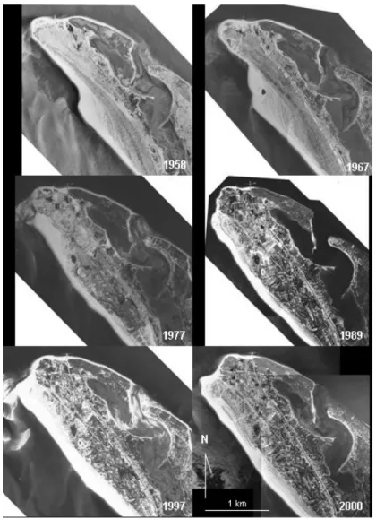
The Tróia peninsula is a 20 km long sandspit, formed by the coalescence, over the last centuries, of a line of barrier islands (Gomes 1992). Contrary to the prevailing erosive tendency observed along the Portuguese coast (e.g. Andrade et al. 2002; Araújo 2002; Soares de Carvalho
et al. 2002; Veloso-Gomes et al. 2002), which is naturally enhanced by global sea level rise, the marine side of the northern part of the peninsula, because of the locally prevailing Northward littoral drift, has been growing steadily, at least over the last half century (Figure 2).
In terms of human occupation, the area went through a first period of tourism development, which started during the late 1960’s and ended in the mid-1970’s.
In 1993, the PROTALI (Regional Land Management Plan of Littoral Alentejo), defined the northern part of the Tróia peninsula as an ADT (Tourism Development Area) at a work scale of 1:150000.
In 1996, the municipality approved the corresponding land zoning plan (PDM – Municipal Director Plan), which delimited, at a scale of 1:25000, both the ADT and the REN (national ecological reserve), according to the 1993 national law that created REN as a nationwide area ensuring the basic ecological functions of the territory (Andrade et al., 1998). This plan was ratified by the Portuguese government.
In 1997, part of the peninsula was included in Site PTCON0011 – Sado Estuary, and presented by the Portuguese government to the European Union as part of the first list of proposed Natura 2000 sites within the framework of the European Habitats Directive (Council Directive 92/43/EEC of 21 May 1992, on the conservation of natural habitats and of wild fauna and flora). This site was delimited at a 1:25000 scale.
In 1998, the Coastal Management Plan (Plano de Ordenamento da Orla Costeira – POOC) for the area, designed by the national Water Institute (INAG) was approved by the Portuguese Government. This plan defines beach zoning, accesses and infra-structures at a scale of 1:25000.
Finally, in 2000, the Portuguese government sold the property to a private group (SONAE) and the municipality approved the Tróia PU (Urbanization Plan) that defines zoning, occupation levels and construction guidelines, at a scale of 1:5000. This plan was also ratified by the government.
However, most of these plans and laws present problems, which directly interfere with territorial management.
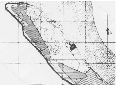
The 1996 PDM used cartography based on field data from the early 1960’s, the zoning units being hand-drawn (Figure 3). Since the peninsula grew hundreds of meters seawards over the 1960-1990 period, every feature in the plan – including the existing constructions – had to be “freely” distorted and compressed to fit in the map. As a result, superimposing an updated aerial photograph to this map, part of what, in the nineties, was urban area, appears in the map as… seawater, rendering it totally useless for management. At the time the PDM was being prepared, cartography from 1994 was already available. The use of an updated base cartography could have minimized this problem. In the same plan, different area types (classes of territory) were delimited with a thick hand-drawn line, about 1 mm wide (Figure 3). At a scale of 1:25000, the 1 mm line on the map becomes a 25 m wide stretch on the field, again making it impossible to effectively use these maps for management.
The Natura 2000 site for the Sado estuary (Site PTCON0011), proposed by the Portuguese government in 1997, was delimited on the same base map as the PDM, from the 1960’s. This map does not yet include the longitudinal road that was used as the western limit of the site, or the constructions, dating from the 1970’s, that define the northern limits of the site. Therefore, the limits of the site were again hand drawn according to the (not very) “educated guess” of the legislator (Figure 4).
Figure 3. Base cartography of the 1996 PDM: zoning units were hand-drawn and existing features compressed to fit in the territory as it was more than 30 years before, when the peninsula was hundreds of meters narrower. At the 1:25000 scale, thick 1mm lines correspond to 25 m on the field. (OA, 1996, Plano Director Municipal de Grândola).
Figure 5. Superimposition of the restrictions and zoningmaps of the Tróia PU. Within the solid line, the area marked simultaneously as national ecological reserve in the restrictions map (vertical lines) and as urban development area in the zoning map (squares) creating an unmanageable situation (OA, 2000, Plano de Urbanização, Peças gráficas).
The Tróia PU also uses a territorial zoning that is not supported by environmental information. Contrary to the findings of the 1998 Strategic Environmental Assessment of the area (cf. Andrade et al. 1998 and Andrade et al. Strategic Environmental Assessment of the Troiaresort, this volume), the PU allocated the highest construction densities to the most recent, dynamic, and therefore susceptible areas of the peninsula (the Northwest sea coast). In doing so, the PU was supposedly trying to reduce loads in the terrestrial ecosystems included in the proposed Natura 2000 site, despite that being an older, more stable, and, in general terms, less sensitive environment than the marine side of the peninsula.
Failure to recognize that marine angiosperm beds, both in the Mediterranean and the Atlantic, need identical protection measures, has lead to an insufficient classification of coastal sites and is effectively undermining conservation needs and efforts across the European Atlantic coast.
3. DISCUSSION AND CONCLUSIONS
Troia’s case is surely not the exception in the Portuguese and European scenarios and clearly demonstrates that the design of legislation for the effective management of coastal zones requires special attention.
The dynamic nature of coastal environments may rapidly render obsolete base cartography, which implies extra care when conceiving and designing planning instruments for these areas. Effective management is not compatible with small scale maps and with “creative” cartography.
On the other hand, the communication of scientific data and knowledge to the legislation level and to the decision-makers, specifically in terms of conservation needs for coastal areas, is still widely insufficient and directly contributes to unsustainable management options.
There is a pressing need for a new praxis in the process of legislating for dynamic environments, which implies a new attitude, both from the policy-makers and from the scientists.
Today’s wide availability of/access to computers and GIS tools, allows clear and precise map-making, and facilitates regular information updates.
On the other hand, scientists (as providers of relevant information), must make an effort to make their results readily available to the legislators, and in a language that can be translated into management options and laws. In this respect, the Water Framework Directive (Directive 2000/60/EC) may help to correct this situation, since it requires a full characterization of water bodies, including their ecological quality and status, based on the monitoring of species and communities as indicators of ecological changes and environmental disturbances.
In order to be sustainable, environmental management must be dynamic and adaptive, constantly incorporating updated information into the management process and adapting management tools and decisions to new environmental information.
Adaptive management implies effective communication between the information providers (the scientists / researchers) and the policy-makers, and it must be supported by adequate legal instruments that integrate and use adequate spatial and temporal scales and the best available environmental information, especially in such dynamic environments as coastal areas.
ACKNOWLEDGMENTS
Work in the Tróia peninsula was made possible by funding from IMOAREIA, SA. within the framework of the environmental strategic evaluation of the Troiaresort through an IMAR-IMOAREIA protocol.
REFERENCES
Andrade, C.F.; Marques, M.; Freitas, C.; Cardoso, R. & Madureira, P. 2002. Shore Platform Downwearing and Cliff Retreat in the Portuguese West Coast. In ‘Littoral 2002.The Changing coast’. EUROCOAST/EUCC. Porto-Portugal. Ed. Eurocoast – Portugal. Volume 2:423-431. ISBN 972-8558-09-0.
Andrade, F.; Baptista, R.; Ferreira, A.; Gomes, N.; Melo, J.J.; Leitão, P. & Pinto, M.J. 1998. ‘Strategic Environmental Assessment for the Tróia peninsula (Estudo Ambiental Estratégico para a península de Tróia)’. Reports 1-2. 38pp+Anexes.
Araújo, M.A. 2002. Relative Sea Level, Diastrophism and Coastal Erosion: The Case of Espinho (Portuguese NW Coast). In ‘Littoral 2002. The Changing coast’. EUROCOAST/EUCC. Porto-Portugal. Ed. Eurocoast – Portugal. Volume 2:125-132. ISBN 972-8558-09-0.
Costanza, R., Andrade, F.; Antunes, P.; van den Belt, M.; Boesch, D.; Boersma, P.D.; Catarino, F.; Hanna, S.; Limburg, K.; Low, B.; Molitor, M.; Pereira, J.G.; Rayner, S.; Santos, R.; Wilson, J. & Young, M. 1998.’ Principles for Sustainable Governance of the Oceans’,
Science, 281, 5374, 198-199 , 10 July 1998.
Costanza, R., Andrade, F.; Antunes, P.; van den Belt, M.; Boesch, D.; Boersma, P.D.; Catarino, F.; Hanna, S.; Limburg, K.; Low, B.; Molitor, M.; Pereira, J.G.; Rayner, S.; Santos, R.; Wilson, J. & Young, M. 1999. ‘Ecological Economics and Sustainable Governance of the Oceans’, Ecological Economics, 31, 171-187.
Ducrotoy, J-P. & Elliott, M. 1997. ‘Interrelations between Science and Policy-Making: The North Sea Example’, Marine Pollution Bulletin, 34, 9, 686-701.
ECDGE 1999. ‘Natura 2000: Interpretation Manual of European Union Habitats – Eur 15/vs. 2’. European Commission, DG Environment. Scientific Reference Document.
Ferreira, M.A. & Andrade, F.. in press. ‘Intertidal communities as indicators of environmental change and their potential use in biomonitoring: the Troia Resort (Portugal), a large-scale tourist development, as a case study’. Boletín del Instituto Español de Oceanografia.
Gomes, N. 1992. ‘Dinâmica Dunar no Arco Litoral Tróia-Sines (Portugal)’. Masters Thesis, Lisbon University. 121 p.
Soares de Carvalho, G., Granja, H.M.; Gomes, P.; Loureiro, E.; Henriques, R.; Carrilho, I.; Costa, A.L. & Ribeiro, P. 2002. New Data and New Ideas Concerning Recent Geomorphological Changes in the NW Coastal Zone of Portugal. In ‘Littoral 2002.The Changing coast’. EUROCOAST/EUCC. Porto-Portugal. Ed. Eurocoast – Portugal. Volume 2:399-410. ISBN 972-8558-09-0.
Taussik, J. & Gilbert, Y. 2002. Communication in Coastal Management: Scientists and Managers. In ‘Littoral 2002.The Changing coast’. EUROCOAST/EUCC. Porto-Portugal. Ed. Eurocoast – Portugal. Volume 1:3-13. ISBN 972-8558-09-0.
Veloso Gomes, F.; Taveira Pinto, F.; das Neves, L.; Barbosa, J.P. & Coelho, C. (2004).Erosion Risk Levels at the NW Portuguese Coast: the Douro Mouth - Cape Mondego Stretch, Journal of Coastal Conservation, Volume 10: 1-2, December 2004, OpulusPress, ISSN 1400-0350, pp.43-52.