1
Doutorado em Sociedade e Cultura na Amazônia pela Universidade Federal do Amazonas. Programa de Pós-Graduação em Sociedade e Cultura na Amazônia – PPGSCA/UFAM
2
Mestrado em Química pela Universidade Federal do Amazonas. Depto. Modelagem/Instituto Amazônia Livre
REDD+ as reducing agent of social inequality in the Brazilian Amazonia:
predictors for a municipality in the central portion of the biome
Renan Albuquerque Rodrigues1 Antônio José do Nascimento Fernandes2
Resumo
O estudo avaliou um projeto REDD+ (Redução de Emissão por Desmatamento e Degradação Florestal) implementado na Amazônia Brasileira em 2013 e ainda em andamento, o qual tende a reduzir as emissões de carbono e incentivar boas práticas sociais às populações impactadas. O software Carbontrack foi usado para estimar o volume de C em função de dados do SIMAMAZONIA. Dimensões humanas foram descritas por etnografia, contexto social e escala de bel-estar subjetivo. Na simulação de desflorestamento, mudanças potenciais de cenários se mostraram incisivas, por conta de pressões de fazendeiros do crescimento de áreas urbanas. Para as dimensões humanas registrou-se potencial para processsos de exclusão social.
Palavras-chave: Mecanismo REDD+; Exclusão social; Amazônia brasileira
Abstract
The study wants understand the extent REDD+ project (Reducing Emissions from Deforestation and Forest Degradation) implemented in the Brazilian Amazonia, started in 2013, can to reduce carbon emissions and provide social inclusion populations impacted. Carbontrack software was used to estimate the amount of carbon from data previously categorized in SIMAMAZONIA. Human dimensions were stipulated for ethnography, social context and application of subjective scale well-being. In the simulation of deforestation, potential changes are present in the central area, by the presence of farms and urban areas. In the scope of human dimensions, there has been an unbalance in the analysis of the processes of reducing social inequality. Key words: REDD+ Mechanism; Social inequality; Brazilian Amazonia
Introduction
In 2007, the fourth report of the Intergovernmental Panel on Climate Change (IPCC), the scientific authority of the United Nations (UN) on causes and effects of global warming, warned of the impact of human activities on global changes in climate. The document emphasized that it is accelerating the concentration of greenhouse gases (GHGs) in the atmosphere, mainly carbon dioxide and methane (CH4 and CO2, respectively). The consequence for the Amazon biome of major importance to the planet, is the change in rainfall patterns and drought in the region, intensifying extreme events and pressing ecosystems and biodiversity (Worm et al., 2006).
Because of these findings and because specific searches conducted in the Amazon in recent years by renowned institutions - such as the National Institute for Amazonian Research
(INPA) and the National Institute for Space Research (INPE) in Brazil; North American Space Agency (NASA) in the U.S., and Hadley Center in England - it is reasonable to believe that the increase in effort by many scientists to understand patterns and global climate variations should find an echo in society more sharply (Marengo et al., 2008; Kemenes et al. 2007).
The dialogue between state and society in order to use scientific studies to format proposals for reducing GHGs is urgent and must be effected in order to consort mitigating activities. One of the actions that could integrate this juncture is the positive management of public lands, for without it rainforest regions, especially national, tend to develop scenarios of abuse of natural resources, exacerbated by the lack of governance and planning.
The projections that take into account sustainable actions and coherent proposals for the management of public lands in the Brazilian
Amazon biome with 5 million km2 and 22 million people, should understand the relationship between society and environment interactively. The interaction, however, work in that State the tripod company biome can be supported in promoting equitable income without the need to impose negative to Amazon.
Taking forward the premise, it is situate the current function of a mechanism for financial compensation related to carbon trading, REDD+ (Reducing Emissions from Deforestation and Forest Degradation, including ensuring best practices of social conservation). The REDD+ was established in 2007 from global discussions
Table 1 – Scope option of REDD+ DENOMINATI
ON
DESCRIPTION OF ABREVIATION
RED Emissions Reducing by deforestation
REDD Emissions Reducing bydeforestation and degradation
REDD+ Emissions Reducing bydeforestation and degradation, conservation and increasing forest carbon stocks and sustainable forest management
REDD++ REDD+ added from reforestation activities, including in areas where there were forests in the past (afforestation)
in the UN meetings. It defines economic value for the protection of forests and biodiversity, generate revenues to finance the transition to a sustainable economy with income generation opportunities for local people.
The probation officer mechanism occurred in the Framework Convention of the United Nations on Climate Change (UNFCCC) in 2010, during the COP 16 held in Cancun, Mexico. Before that, there were different denominations who sought to explain the concept, these being the ones described below.
Even though the carbon market is at an early stage, some of the economic compensation through REDD+to the integrity of ecosystems it may be realities in the medium term in the Amazon, where in 2009 an experiment of the type began to be implemented, though with a different method fundraising, based on voluntary donations in cash (Verified Carbon Standards - VCS).
The project is located in force on Sustainable Development Reserve (RDS) Juma, Novo Aripuanã, southern Amazon. And despite the fact that REDD+ does not have the feature directly reduce GHG emissions, but offset indirectly populations potentially polluting and mitigating actions unsustainable multinational groups, there is no doubt that the mechanism points to a promising prospect to Amazonians booking, directing income to that population.
Considering this example guided
activity in the carbon market, objective of the study was to identify predictors for the latest
survey potential to generate such certificates in the Brazilian Amazon, with planning underway since 2009 and expected to start in 2013. The design of REDD+ Borba (Borba PDD) was evaluated in its potential implications in reducing carbon emissions and in terms of its role in providing social inclusion for the people impacted.
The Project REDD+ Borba was
developed by researchers of the Federal University of Amazonas (Ufam) and the Land Institute of the State of Amazonas (ITEAM) within the model Ecometric - Natural Forest
Standard (ECO-NFS), which avoided
deforestation along with the degree of
biodiversity value of portions of land available to the project are taken into consideration to measure the value of marketing carbon credits.
Theoretical approach carbon market and
REDD+
Carbon market is a term used to describe trading systems certified emission reduction of GHGs. Carbon credits, in turn, are themselves generated certificates into this market, which attest that a particular activity (planting controlled domestic harvest seeds, traditional fishing etc.) Led it to reduction of emissions or capture of GHGs. The market is divided into two types: "official" and "voluntary." The difference lies in the demand for credits: are companies that have a legal obligation to reduce emissions or
business groups who voluntarily assumed goals, even if not required (Valle and Yamada, 2012). The REDD+ model is rated "official" within the global carbon market. Despite the signatories of the Kyoto Protocol have not established global rules for its operation, the proposal currently in vogue is that developing countries (Brazil among
them) reduce, verifiably, their levels of
deforestation compared to a historical average preset. If this occurs, populations in areas where there was a reduction should be financially compensated for the effort.
Inequality, the exclusion consequence
Understanding the meaning of social inequality helps set a solid foundation for studying the compensation system of the carbon market. The coherence of the concept helps sedimentary knowledge on effective actions to reduce the gap between included and excluded in the biome. In this sense, we have that inequality is part of a theoretical matrix to be understood by previous thinking about another problem, that of social exclusion.The term social exclusion tends to refer to inequality, poorness, poverty or deprivation in general. Being excluded is to be deprived of any mechanism that helps provide quality of life for the individual. For Cato (2005), social exclusion is the degradation of the identity of the person or group too, which fosters finally, disintegration and disruption of social relationships.
Exclusion refers to a temporal and spatial sense, because a community is to be deleted or second given geographical area or in relation to social and economic conditions of the country to which it belongs. Xiberras (1993) considers excluded people who are unable to integrate the markets for goods or cultural materials. Castel (1991) interpret the exclusion as disaffiliation, which represents a breach of belonging and societal bonds. For him, the rupture of the social bond is given by insufficient material resources associated with the fragility and instability of the social fabric.
Methods - Study area
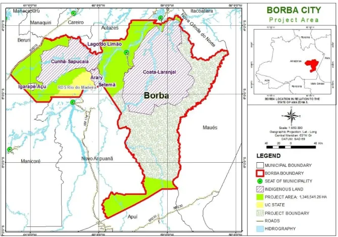
The area studied is inserted in the municipality of Borba, Amazonas State, Brazil (Figure 1). In the current geographical division, the city is part of the 5th sub-region of the Madeira River, which is also formed by the cities of Apuí, Humaitá, Manipur and New Aripuanã.
Distant 150 km from Manaus straight and by river to 215 km, the place has an area of 44,367.7 km².
Besides the headquarters of the city, there are 260 officially registered communities that form Borba, counting headquarters and district council areas, where approximately 34 500 people. Communities, 107 (40%) consisted in all areas investigated. Indian lands were excluded (TIs) contained within the municipality. Three zones, with an extension of 1,346,541.26 hectares, were analyzed.
Was investigation item the carbon credits marketing project directed to the municipality. Aspects related to: i) the volume of carbon, ii) estimate the instruments and iii) human dimensions deserve specific attention in the analysis of potential impacts in reducing social inequality in Borba. Were delimited subtopics below for verification of the proposed
methodology in this project REDD+ Borba.
Items tested
The volume of carbon
The carbon stored in biomass
considered in the PDD in Borba was
374,144,947.8259 tons of CO2e a total estimated 704,702,766.464 tCO2e for the territory of Borba. Inventories have not considered Environmental Protection Areas (APAs) in the city.
The estimate Instruments
Carbontrack software was used to estimate the amount of carbon from data previously categorized in SimAmazonia approach and risk methodology ECO-NFS, which seeks to strengthen standards for estimating carbon risk arising from natural tropical forests. The metric is the validator Ecométrica, headquartered in
Scotland (Edinburgh).
The Carbontrack served to describe the density of carbon. In this study, the use of SimAmazonia was directed to a 20-year period of deforestation area simulated as part of the Amazon in general. In the context of risk approach, the perspective was to direct the analysis to the specific area of the project.
Parcels of land referent conservation units (CUs) and TIs were obtained from the database of the State Secretariat of Environment and Sustainable Development (SDS) and the Socio-Environmental Institute (ISA), respectively.
Figure 1. Map f the Project area e its surround. Source: IAL, 2013.
Human Dimensions
The measurement of the credit of carbon market impacts on the human dimensions of the municipality was stipulated as follows: i) assessing the quality of life for ethnography (Tajfel, 1982; Sá, 1998), ii) description about the perception of improved real life through the
interpretation of social context revealed
(Garfunkel 1978; Sá, 1998), and iii) application of scale related to subjective well-being of the population (and Amérigo Aragonés, 1991).
Procedures for data analysis For the volume of carbon
To evaluate the quantification made for the volume of carbon crediting the municipality was used to fit the density in the forests of the study area from the SimAmazonia ratings and risk analysis.
The data considered in equilibrium with the carbon densities present growth rate of 43 tC / ha, similar to those previously reported for the regions (Nogueira, et. Al., 2008a; Nogueira et. Al., 2008b). The main vegetation types (Figure 2) analysis were dense rain (tropical forest river), open rain (transition forest) and ombrophilous of
submontanha (dense rainforest).
To estimate the instruments of estimation
The classifications resulting from the simulation of SimAmazonia were obtained from images acquired from Remote Sensing Center of the Federal University of Minas Gerais (UFMG) (Soares-Filho et. Al., 2006).
The risk ratings from the ECO-NFS methodology, were performed using the software ArcGis 10 and QuantumGIS 1.7, by drafting bufering lines and polygons of geographic information airways, waterways, businesses and occupations of the study area.
From the vegetation map (Figure 2) were determined on 13 different fragments of their classes to facilitate the calculations of carbon stock. In these fragments were applied
classes obtained through the results of
SimAmazonia risk classes and the methodologies ECO-NFS.
By means of the procedures was possible to obtain the results of deforestation estimates for the next 20 years in the two approaches, and methodology SimAmazonia ECO-NFS.
For the human dimensions
About the work of ethnography and
social context revealed, we took into
consideration that analyze the design of REDD+ activity Borba suggests how systematic collection of popular perception of quality of life.
We evaluated the potential of
understanding of the problem by means of meta-analysis of topical 5.1. Document based project,
entitled "Description of positive and negative socioeconomic impacts of proposed activities in the project communities within the project area and communities legally established outside the project area agreeing with access rights and resource use."
Was also made to directed literature review process scale validation of subjective well-being. The goal was to investigate the cohesion of the instrument addressed to reality.
Figure 2. Vegetation map of the project area, according to the IBGE classification. Source: IAL, 2013.
Results and Discussion
Spatial analysis of land use
For the described project area clippings of the results presented by the SimAmazonia simulation were verified. At work, there was consideration of descriptors that influence the process of deforestation and submitted to the
simulation transition functions based on
neighborhood spatial multi-scale. The simulation was performed by stochastic multistep process, with feedback from spatial calculations of
dynamic variables.
The spatial variables used to calibrate the model were slope, altitude, distance from main roads, protected areas and lithology. They favor the explanation of changes in land use during the period of the simulation. The process considers
the weights of evidence based on the conditional probability theorem Bayes (Bonham-Carter, 1994), which uses Bayesian and probability model was originally developed for evaluation of mineral potential.
For land use, the method confirms the probability that a class undergoes change (eg 'use vegetation to non-urban'), since evidence (eg slope) has already occurred. In weights of evidence, the effect of a variable spatial a transition is calculated independently of the combined solution. The weights of evidence each represent a variable influence on the probability of a transition space i, j are calculated according to equations 1 and 2 (Soares-Filho et al., 2003a).
(equation 1)
(equation 2)
Where The {D} and O {D / B} are the
odds, respectively, of the event occurs a priori D and D occur as a spatial pattern B. + W is the weight of evidence of the event occurs D, given a spatial pattern B (Bonham-Carter, 1994; Soares-Filho et. al., 2003).
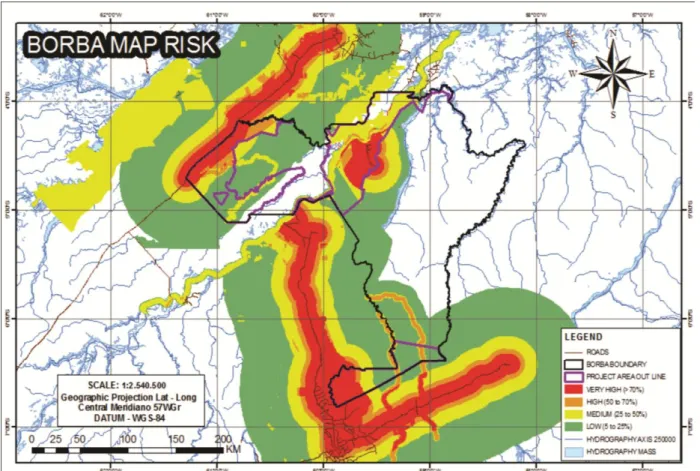
The composition of the figures below (3) shows the evolution of deforestation within 30 years to the trocano project area, according to the
Figure 3 - Growth rate of deforestation in the municipality of Borba over 30 years. Source: IAL, 2013.
In the simulation of deforestation process the variables slope, elevation, distance to major highways, protected areas and lithology to build the model SimAmazonia indicate that the greatest changes are present mainly in the central area, near the county seat, by the presence of farms and urban areas. There is also a great evolution of deforestation in the western region, for having access area BR-319. In the trocano project area contained in southern municipality of Borba is checked a small influence of the BR-230 (road), this being a road with large tracts of land without governance.
Through the SimAmazonia data was obtained results with considerations relevant to
the entire Amazon region, which could lead to lack of more precise description in the case of the project areas. Thus, other procedures were performed which could include local features such as that appears below.
For the local approach we adopted descriptions of risks by the standards contained, the risk factors considered are presented in Table
2 below. As a result of the associations presented
in the table above, is found the risks classified spatial determinations patterns of natural forests of Natural Forest Standard (base platform technical-scientific pointing parameters to be considered in estimates of biodiversity and biomass, available at www . thenaturalforeststandard.org).
The results were measured from information obtained from a survey conducted during trocano project preparation, taking into account areas shown on the maps below. Knowledge about lifestyle, traditions and economic systems to treat the environment they were decisive in objective evaluations, based on estimates of software.
In this context, to discuss the risk map of Borba was imported: i) the identification of variations related to small and microagricultores, overwhelmingly in rural areas and ii) the analysis of the problems of a technical and financial assistance for planting .
Among the main differences, comparing the spatial data obtained with the SimAmazonia and analysis of potential of risks of deforestation recorded for the trocano project areas, note the existence in the south of the mainly influence the effect of the local approach, where they achieved higher areas and larger diversity of classifications in the second approach. With this, the same distances greater access to highways BR-230 (road) and AM-174 (road) are perceived pressures that approach and at different intensities.
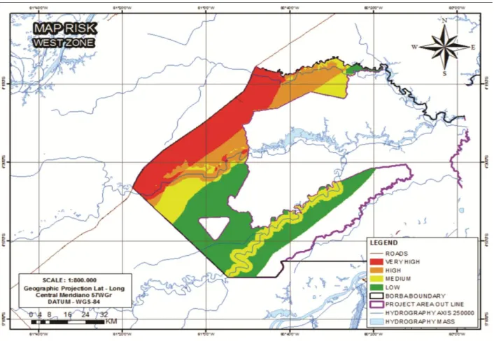
What happens in the southern also observed in Western, as highlighted in figure 6, but with minor differences.
In the central region, Figure 7 below, the similarities are held on the main agents of deforestation, however, for the Madeira river bank, opposite the town of Borba, the approach of SimAmazonia presents major deforestation in relation to classes of Risk analysis (Table 2).
The volume increase in deforestation indicates the degree of pressure to ecosystems. As a variant of this process, there is a lack of autoregulation of communities that have transformed its economy from a commodity incentive projects.
What would become of the traditional economy in the area influenced by progressive deforestation would be supported in family relationships, neighborhood and cronyism. The broader collective practices still exist today, would be covert and consolidation of the domestic economy or even the likelihood it sustain itself from the natural resources available would be reduced to drastic levels.
Human dimensions: Quality of Life
Within the scope of human dimensions, and based on the fact that the realization of
actions of social inclusion is concretely realized in a horizon of up to two years (short term) to people directly involved and five years (medium term) for populations indirectly involved in the project, there has been an unbalance in the analysis of the processes of reducing social inequality.
First, because the non-observance of three qualitative indicators biodemographical — i) income, ii) education level and iii) access to the health system business as usual scenario — the measurement of subjective perception about the personal welfare and collective tends to skew this analysis.
Second, because there will be a directing financial resources obtained with carbon credits for practices geared to basic needs food and affective, this perspective would be the single component to reducing the incidence in rural Borba of exclusionary practices, which would make it impossible the process.
Moreover, is imminent the record of conflicts if the developmental plans originated in the Amazon trade in commodities continue to be supported by industrialization at any cost and encouraged by the State in the biome. The breakdown of the rural world, guided by social inequality, will be accelerated.
It is the unfolding of a modernity increasingly attracted and fascinated by material progress, which in no way guarantees happiness and well-being, whether in urban or rural areas, but it contributes to the intensification of polemics between groups.
Social context revealed
By modifying the meaning of work from the REDD+ mechanism, this activity while liberating action and generating meanings of world, may fail to provide your agent, the worker, means to his emancipation. The powerlessness of the individual from field may rise, facilitating spaces for generating intergroup conflicts driven by stress states.
The beneficiaries for environmental services in Borba may pass a strong process of acculturation, mystified and presented as a benefit for the population itself funded by this model of green economy, the payment for environmental services. The emotions related to things and members of the municipality of collective identification with the stories of struggle tend to tackle fragmentation depending on the activity.
Figure 4. Risk map with classification risk by accessibility, susceptibility and demand. Source: IAL, 2013.
Figure 5. Risk Map with risk rating for accessibility, and susceptibility to demand the southern municipality of Borba. Source: IAL, 2013.
Figure 6. Risk Map with risk rating for accessibility, susceptibility and demand for the area west of the town of Borba. Source: IAL, 2013.
Figure 7. Risk Map with risk rating for accessibility, and susceptibility to demand the central zone of the municipality of Borba. Source: IAL, 2013.
Given the discontinuity of social representations of world traditional and the acceleration in the cultural dispersion process in face of contact with urban populations, human relations within the affected area will tend to undergo a dynamic occidentalization. The project is expected to safeguard, against strong tendency to confront the autonomy of the traditional ones, propensities with serious lack of otherness against the popular knowledge.
Economically, the source of funds for financing REDD+ is in trocano project, subject to market availability, which means that in its early stages the activity should not be financed by public funds and will not be the responsibility of proposing institutions. The situation can cause discomfort and hopelessness among rural targets of action, resulting in conflict situations.
The practice of good environmental governance is an important factor to ensure the sustainability and integrity of REDD+. Recognizing the complexity of the different interests of the population on the supply and use of natural resources is a fundamental attitude to establish the sustainable use of resources and continuity of the mechanism.
EBES-62 Scale
There is no consensus in the literature on how to measure the scale of subjective well-being of 62 items (EBE-62). The aspects can be measured by optimism, happiness, positive affect, negative affect, emotional balance, depression and anxiety. The most common form is a balance between positive and negative affects. The positive emotions are pleasurable emotions such as joy, pride, affection and pleasure, while the negatives include unpleasant emotions such as sadness, anxiety, depression, anger, shame and anger.
It can be said that the positive affect corresponds to a pure hedonic contentment, experienced at a given time as a state of alertness, enthusiasm and activity. The negative affect is seen as a state of distraction and engagement negligible, which is also transitional, but that includes negative emotions. The terms "affection", "emotions", "moods" and "feelings" are used indistinctly. The two indicators of emotional EBES are distinct constructs and have inverse correlation, in other words, the higher the level of positive affect, lower the level of negative affect, and vice versa (Albuquerque, 2005; Tróccoli and Albuquerque, 2004).
Based on this perspective, the use of correspondence analysis tend to be the most
effective method when the project trocano Araretama is predisposed to evaluate the opinions expressed by the members of the areas benefited from the payment of environmental services through REDD+. As the mechanism promotes the reduction of greenhouse gas emissions, there must be also the articulation of strategies at long-term conservation of forest resources.
Accordingly, lenders of REDD+ must be willing to allocate resources in activities without direct correspondence with measurable results of the greenhouse gas emissions reduce or the increase forest carbon stocks in the early stages of deployment activity until measurable results can be obtained.
References
ALBUQUERQUE, F.J.B. et al. 2005. Integração entre assentados agrários e comunidades vizinhas. Psicol. Estud., Maringá, v. 10, n. 3, Dec. 2005. Disponível em: <http://www.scielo.br/scielo.php?script=sci
_arttext&pid=S1413-73722005000300018&lng= en&nrm=iso>. Acesso em 1º de dezembro de 2008. doi: 10.1590/S1413-73722005000300018. ALBUQUERQUE, A.; TRÓCCOLI, B. 2004.
Desenvolvimento de uma escala de Bem-Estar Subjetivo. Revista Psicologia: Teoria e Pesquisa, v. 20, n. 2, p. 153-164.
ARAGONÉS, J.I. & AMÉRIGO, M. 1991. Um estúdio empírico sobre las actitudes ambientais. Revista de Psicologia Social, 6, 223-240.
BONHAM-CARTER, GF. 1994. Geographic information systems for geoscientists, modelling with GIS. Pergamon, Tarrytwon, vol. 13, New York.
BOURDIEU, P. & CHAMPAGNE, P. 2001. Os excluídos do interior. In Bourdieu, P. (org.) A miséria do mundo. 4ª ed. Petrópolis: Vozes.
CASTEL, R. 2004. De l'indigence à l'exclusion, la désaffiliation: précarieté du travail et vulnerabilité relationnelle. In J. Donzelot (Org.), Face à l'exclusion — le modèle français (pp. 137-168). Paris: Esprit. In Feijó, M.C., Assis, S.G. (2004). O contexto de exclusão social e de vulnerabilidades de jovens infratores e de suas famílias. Estud. psicol. (Natal), Natal, v.9, n.1. Disponível em: <http://www.scielo.br/scielo.php?script
=sci_arttext&pid=S1413-294X2004000100017&lng=pt&nrm=iso>. Acesso em: 27 Dez 2006. Ano da obra:
1991. doi: 10.1590/S1413-294X2004000100017.
CATÃO, M.F.F.M. 2005. Exclusão/Inclusão Social e Direitos Humanos. In. Tosi, G. Direitos Humanos: História, Teoria e Prática. João Pessoa, Editora Universitária/UFPB.
GARFINKEL, H. 1995. Studies in Ethnomethodology. Cambridge England: Polity, 1984. In: Coulon, A. Etnometodologia. Tradução de Ephraim Ferreira Alves. Petrópolis, Vozes.
KEMENES, A.; FORSBERG, B.R.; MELACK, J.M. 2007. Methane release below a tropical hydroelectric dam. Geophisical Research Letters. . Vol.: 34, L12809. DOI: 10.1029/2007GL029479.
MARENGO, A.; NOBRE, A.; NOBRE, C.; TOMASELLA, J.; CARDOSO, M,. OYAMA, M. 2008. Hydro-climatic and ecological behaviour of the drought of Amazonia in 2005. Philosophical Transactions of the Royal Society of London. Biological Sciences 21: 1-6. NOGUEIRA, E.M.; FEARNSIDE, P.M.;
NELSON, B.W.; BARBOSA, R.I. & KEIZER, E.W.H. 2008a. Estimates of forest biomass in the Brazilian Amazon: New allometric equations and adjustments to biomass from wood- volume inventories. Forest Ecology and Management 256(11): 1853-1857.
NOGUEIRA, E.M.; FEARNSIDE, P.M. & NELSON, B.W. 2008b. Normalization of the wood density data used in estimates of above-ground live biomass in Amazon forests. Forest Ecology and Management 256(5): 990- 996.
SÁ, C. 1998. A construção do objeto de pesquisa em representações sociais. Rio de Janeiro. Ed: URJ.
SOARES-FILHO, B.S.; NEPSTAD, D.; CURRAN, L.; VOLL, E.; CERQUEIRA, G.; GARCIA, R.A.; RAMOS, C.A.; MCDONALD, A.; LEFEBVRE, P. & SCHLESDINGER, P. 2006. Modeling conservation in the Amazon basin. Nature, London, v. 440, p. 520-523.
TAJFEL, H.1982. Grupos humanos e categorias sociais. Lisboa: Livros Horizonte.
VALLE, R.S.T. & YAMADA, E.M. 2012. Brasil: titularidade indígena sobre créditos de carbono gerados por atividades florestais em terras indígenas. ISA - documento
eletrônico. Endereço:
www.socioambiental.org/banco_imagens/p dfs/redd brasilfinal.pdf, acessado em 05/03/2012.
XIBERRAS, M. 1993. As Teorias da Exclusão para uma Construção do Imaginário do Desvio. Lisboa: Instituto Piaget.
WORM & cols. 2006. Pesca comercial vai acabar em 2048, indica projeção. In http://agenciact.mct.gov.br/index.php/conte nt/view/42046.html. Com dados de www. sciencemag.org. Acessado em 07/12/2006.