Spatial distribution of deaths due to Alzheimer’s disease in
the state of São Paulo, Brazil
Distribuição espacial de óbitos por doença de Alzheimer no estado de São Paulo
Milena Cristina da Silva Almeida
I, Camila de Moraes Santos Gomes
I, Luiz Fernando Costa Nascimento
IIUniversidade de Taubaté (UNITAU), Taubaté, São Paulo, Brazil
ABSTRACT
CONTEXT AND OBJECTIVE: Alzheimer’s disease is a common cause of dementia and identifying possible spatial patterns of mortality due to this disease may enable preventive actions. The objective of this study was to identify spatial distribution patterns of mortality due to Alzheimer’s disease in the state of São Paulo.
DESIGN AND SETTING: Ecological and exploratory study conducted in all municipalities in the state of São Paulo.
METHODS: Data on Alzheimer’s disease mortality in the state of São Paulo between 2004 and 2009 were obtained from DATASUS (the Department of Informatics in the Brazilian Ministry of Health). Death rates per 100,000 inhabitants were then calculated and spatial analysis was performed by constructing a death rate map, global Moran index and local Moran index, which were used to obtain the Moran map. The kernel technique was also applied. The Terra View 4.0.0 software was used.
RESULTS: 13,030 deaths due to Alzheimer were reported in the state of São Paulo (rate of 5.33 deaths/100,000 inhabitants). São José do Rio Preto, Ribeirão Preto, Bauru and Araçatuba had higher rates. The Moran index was I = 0.085 (P < 0.002). The Moran map identiied 42 municipalities that merit interven-tion and the kernel estimator identiied a high density of deaths in the northwestern region of the state.
CONCLUSION: Higher densities of deaths due to Alzheimer were concentrated more to the north and northwest of the state of São Paulo. It was possible to identify municipalities that have priority for interven-tions to reduce the death rates due to this disease.
RESUMO
CONTEXTO E OBJETIVO: A doença de Alzheimer é uma frequente causa de demência e a identiicação de possíveis padrões espaciais da mortalidade por essa doença pode permitir ações preventivas. O objetivo do trabalho foi identiicar padrões espaciais da distribuição da mortalidade por doença de Alzheimer no estado de São Paulo.
DESENHO E LOCAL DE ESTUDO: Estudo ecológico e exploratório realizado em todos os municípios do estado de São Paulo.
MÉTODOS: Foram obtidos, do DATASUS (Departamento de Informática do SUS, Sistema Único de Saúde), dados sobre mortalidade por doença de Alzheimer, no estado de São Paulo entre 2004 e 2009. Foi calcu-lada a taxa de óbitos por 100.000 habitantes e realizou-se a análise espacial, por meio da construção do mapa da taxa de óbitos, do índice global de Moran e do índice local de Moran, utilizado para a obtenção do Moran Map. Aplicou-se também a técnica de kernel. Foi utilizado o programa TerraView 4.0.0.
RESULTADOS: Foram notiicados 13.030 óbitos por Alzheimer no estado de São Paulo (taxa de 5,33 óbi-tos/100.000 habitantes). São José do Rio Preto, Ribeirão Preto, Bauru e Araçatuba apresentaram altas taxas. O índice de Moran encontrado foi I = 0.085 (P < 0,002). O Moran Map identiicou 42 municípios que merecem intervenção e o estimador de kernel identiicou alta densidade de óbitos na região noroeste do estado.
CONCLUSÕES: Maiores densidades de óbitos por Alzheimer se concentraram mais ao norte e noroeste do estado de São Paulo. Foi possível identiicar municípios que têm prioridade de intervenção para dimi-nuição das taxas de óbitos por esta doença.
IMedical Student, Department of Medicine,
Universidade de Taubaté (UNITAU), Taubaté, São Paulo, Brazil.
IIPhD. Assistant Professor, Department of
Medicine, Universidade de Taubaté (UNITAU), Taubaté, São Paulo, Brazil.
KEY WORDS: Alzheimer disease.
Geographic information systems. Residence characteristics. Mortality.
Health of the elderly.
PALAVRAS-CHAVE: Doença de Alzheimer.
Sistemas de informação geográica. Distribuição espacial da população. Mortalidade.
INTRODUCTION
Alzheimer’s disease (AD), a common cause of dementia, is characterized by progressive neurodegenerative ders with progressive loss of memory and behavioral disor-ders that diminish individuals’ quality of life. Extracellular amyloid plaque and intraneuronal neurofibrillary tangles accumulate.1,2
The prevalence of dementia in several regions of the world ranges from 1.17% in the population between 65 and 69 years of age to over 50% of the population over 95 years of age.3
A Brazilian study identified a prevalence of 7.1% for any type of dementia in the elderly population, and 54% of the cases were AD.4 The female sex has been identified as the one most
affected by AD, but it is not yet known whether this is due to a genetic factor or because women are more prevalent in the elderly population.3,4 A review of the Brazilian literature
found a prevalence of dementia ranging from 5.1% to 19% in São Paulo, which may indicate that São Paulo has a prevalence closer to that of developed countries than to the prevalence in other regions of Brazil.5
With the progressive aging of the population, and the esti-mate that in 2025 there will be 34 million people over 60 years of age in Brazil,6 the incidence of AD is increasing every year
and has become a public health problem.7 The main cause of
the disease is genetic, but states of toxicity to infectious agents, aluminum, free oxygen radicals and neurotoxic amino acids have already been shown to be factors implicated.8,9
Mapping of disease has becomes an important public health tool, in relation to both diagnosis and planning. Spatial analysis enables implementation of health programs that include several municipalities or regions of a state and thus has also become an important tool for public health diagno-sis and planning.10,11 The rapid development of technologies
for data analysis covering geographical space has provided innovative possibilities for studying the health situation and its trends, thus allowing better understanding of the socioeco-nomic and environmental factors.12
An overview of environmental conditions and population health can be provided by maps that enable observation of the spatial distribution of risk exposures and health problems.13
hematic maps can be used with an exploratory approach, since they show the location of the event and unknown etiological fac-tors that hypothetically may be used to point out links between the event and its causes.14
OBJECTIVE
To identify spatial distribution patterns of mortality rates due to Alzheimer’s disease in the state of São Paulo over the period from 2004 to 2009.
METHODS
Type of study
his was an ecological and exploratory study using data on mor-tality due to Alzheimer’s disease obtained from the Department of Informatics of the Ministry of Health (DATASUS)15 for the
period between January 1, 2004, and December 31, 2009.
Setting
his study was conducted in 645 municipalities in the state of São Paulo, Brazil, which has more than 40 million inhabitants.
Sample
We used data on mortality due to Alzheimer’s disease obtained from the DATASUS Mortality Information System (SIM). hese data were coded in accordance with ICD-10, in the G30 group of causes (061 Alzheimer Disease).
Procedures
Initially, a database was constructed with all the cases of mor-tality due to Alzheimer’s disease. hese cases were analyzed as the rate per 100,000 inhabitants. his spreadsheet, in DBF for-mat, was imported by means of Terra View 4.0.0, which is a pub-lic-access sotware developed by INPE (http://www.dpi.inpe.br/). he spatial analysis was performed on a digital database of the municipalities of the state of São Paulo that was obtained from the Brazilian Institute of Geography and Statistics (IBGE).
Statistical analysis
he analysis estimated the spatial autocorrelation coeicient of events by means of the global Moran index (I). he global Moran index establishes the degree to which the value of a variable in a region (a city, for example) is similar to the values for this same variable in neighboring regions. he values of this index can range between –1 and +1. he closer to +1 that the index is, the greater the similarity is between that region and its neighbors, with regard to the variable studied. On the other hand, the closer to –1 that it is, the more diferent (less similar) the values of this region are, in relation to neighboring regions. If the value is zero, this indicates spatial independence.
spatial association, such that a place had neighbors with diferent values. he municipalities targeted for intervention would be those located in Q1. he Moran map was constructed, which was the representation of the local Moran index.
Only the municipalities for which the LISA values were considered signiicant were highlighted, with assigned val-ues of one. he other areas did not have signiicance. In addi-tion to these indices, we used the statistical technique of ker-nel smoothing, which identiied the areas of highest density of cases.
RESULTS
Between 2004 and 2009, 13,030 deaths due to Alzheimer’s disease were reported in the state of São Paulo, representing a rate of 5.33 deaths per 100,000 inhabitants.
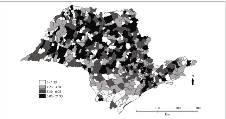
Figure 1 shows the spatial distribution of mortality due to Alzheimer’s disease. It can be seen that in the north and northwest of the state, there was greater concentration of high rates of deaths per 100,000 inhabitants. The cities of São José do Rio Preto, Ribeirão Preto, Bauru and Araçatuba had rates of between 7.56 and 10.40 deaths/100,000 inhabitants. In the central region of the state, the municipalities highlighted were Rio Claro, Botucatu, Piracicaba and Limeira, which showed rates of between 6.90 and 12.00/100,000 inhabitants. In the southeastern and coastal regions, the municipalities of São Caetano do Sul, with a rate of 19.42, and Santos, with a rate
of 13.39, had the highest rates and were the only ones high-lighted. In the southern region of the state, low rates of deaths due to AD predominated.
he spatial analysis results showed that the global Moran index (I) was 0.09 (P < 0.01), thus showing a positive spatial auto-correlation for deaths due to AD. Figure 2 shows the map of the kernel death rate per 100,000 inhabitants, clearly indicating a hot spot in the northern region of the state, around the city of São José do Rio Preto. Figure 3 shows the Moran map, on which the municipalities with high priority for intervention are indicated. hese municipalities need to be better investigated, since they have high rates and are also surrounded by other municipalities with high rates.
he municipalities indicated with lighter colors are cities with low priority for attention, because they showed low rates. Some of these municipalities are in the south, toward the state of Paraná.
DISCUSSION
his study identiied municipalities with high rates of deaths due to AD. It was the irst, as far as we know, to use spatial analysis to identify clusters of municipalities with high rates of this outcome, in the state of São Paulo.
he number of cases of AD has increased because of the age-ing of the population, given that this disease afects the elderly, and also because better diagnoses have been accomplished. he
0 - 1.23 1.23 - 3.30 3.30 - 6.05 6.05 - 21.93
0 100 200 300
Km
N
advances in diagnosing AD have come from more elaborate clinical, laboratory and imaging examinations and from better understanding of AD and other types of dementia, thus enabling characterization in terms of patient history, physical examina-tions and application of tests on cognition, memory, attention,
executive functions and other tests.16 However, knowledge about
the disease and these advances in diagnosis are not yet available for all municipalities, and one limitation of the present study is the possibility of wrong diagnosis of the disease, especially in poorer districts, along with underreporting.
0 100 200 300
Km
N
Figure 2. Thematic map of kernel estimator for death rate per 100,000 inhabitants, due Alzheimer’s disease, state of São Paulo, 2004-2009.
Medium High Low
0 100 200 300
Km N
Although AD is a genetic disease, observation of the spatial distribution seen in this study makes it possible to hypothesize that other predisposing factors may be involved, such as envi-ronmental factors. As an example, given that sugar cane, oranges and lemons are widely cultivated in this region, use of pesticides on these crops could be one of these factors. A cohort study con-ducted on an elderly population in France showed that occupa-tional exposure to pesticides suggests that neurological disability will be present. he study showed that occupational exposure to any pesticide was associated with a twofold increase in the risk of development of AD.17 Chronic exposure, even at low doses,
is associated with neuropsychiatric symptoms, and therefore an association between chronic exposure to pesticides and devel-opment of neurodegenerative diseases should be taken into consideration.18
Another possibility would be exposure to magnetic ields. A relationship between exposure to high voltage lines and mag-netic ields and development of cancers such as leukemia has been suggested in several studies,19,20 and this is also a possible
factor in the development of AD.
he presence of highways such as Washington Luiz (SP-310), Transbrasil (BR-153), Marechal Rondon (SP-300) and Euclides da Cunha (SP-320) in the north and northwest of the state of São Paulo may cause air pollution, which may be relected in devel-opment of diseases such as respiratory diseases, thus perhaps forming another environmental factor that contributes towards development of AD.
As has been pointed out in other studies,8,9 there may be an
association between exposure to aluminum and AD. Aluminum and its derivatives are used in water treatment, food process-ing, pharmaceutical manufacture and foundries, thus leading to occasional human exposure to this metal.
his study has limitations such as those that are intrinsic to ecological studies. Moreover, there may have been errors in ill-ing out the primary cause on the death certiicate, thus leadill-ing to underreporting. Moreover, it is also possible that some people died due to Alzheimer’s disease as a secondary cause, but were not identiied, thus compromising the total number of events.
Demographic parameters were not considered in this study because they are not available through DATASUS. he IPRS, i.e. the Index of Social Responsibility, created by the State Data Analysis System (SEADE), which takes into account wealth, lon-gevity and schooling as parameters for assessing the situation of each municipality, could have been taken into consideration. However, the main objective here was to identify the spatial pat-tern of deaths due to Alzheimer’s disease.
he strength of this study is that it indicates municipalities in which health managers can implement interventions. Even though the high rates in these regions may have been due to better
diagnosis, these are still municipalities in which investigation of occurrences of Alzheimer’s disease are merited. hese interven-tions will allow future comparisons with current data.
Further research will be based on the present study, includ-ing sociodemographic data. his study ills a gap in the literature on Alzheimer’s disease and it is diicult to compare it with other Brazilian data.
CONCLUSIONS
Between 2004 and 2009, the mortality rates due to Alzheimer’s disease were higher in the north and northwest of the state of São Paulo. From observation on the distribution of deaths due to Alzheimer’s disease, it is concluded that spatial analysis is a relevant technique for studying this disease, because it enables identiication of clusters of cities, thereby making better focused actions possible.
REFERENCES
1. Cummings JL. Alzheimer’s disease. N Engl J Med. 2004;351(1):56-67. 2. Sereniki A, Vital MABF. A doença de Alzheimer: aspectos
isiopatológicos e farmacológicos [Alzheimer’s disease: pathophysiological and pharmacological features]. Rev Psiquiatr Rio Gd Sul. 2008;30(1 supl 0).
3. Lopes MA, Bottino CMC. Prevalência de demência em diversas regiões do mundo: Análise dos estudos epidemiológicos de 1994 a 2000 [Prevalence of dementia in several regions of the world: analysis of epidemiologic studies from 1994 to 2000]. Arq Neuropsiquiatr. 2002;60(1):61-9.
4. Herrera Junior E, Caramelli P, Nitrini R. Estudo epidemiológico populacional de demência na cidade de Catanduva, estado de São Paulo, Brasil [Population epidemiologic study of dementia in Catanduva city: state of Sao Paulo, Brazil]. Rev Psiquiatr Clin (São Paulo). 1998;25(2):70-3.
5. Fagundes SD, Silva MT, Thees MF, Pereira MG. Prevalence of dementia among elderly Brazilians: a systematic review. Sao Paulo Med J. 2011; 129(1):46-50.
6. Ramos LR, Veras RP, Kalache A. Envelhecimento populacional: uma realidade brasileira [Population aging: a Brazilian reality]. Rev Saude Publica. 1987;21(3):211-24.
7. Aprahamian I, Martinelli JE, Yassuda MS. Doença de Alzheimer: revisão da epidemiologia e diagnóstico [Alzheimer’s disease: an epidemiology and diagnosis review]. Rev Soc Bras Clin Méd. 2009;7(1):27-35.
8. Smith MAC. Doença de Alzheimer [Alzheimer disease]. Rev Bras Psiquiatr. 1999;21(supl. 2):SII3-SII7.
10. Soares PA, Nascimento LFC. Análise espacial das internações por doenças do coração no Vale do Paraíba [Spatial analysis of hospitalization for heart diseases in Vale do Paraíba]. Arq Bras Cardiol. 2010;94(6):747-53.
11. Nascimento LF, Batista GT, Dias NW, et al. Análise espacial da mortalidade neonatal no Vale do Paraíba, 1999 a 2001 [Spatial analysis of neonatal mortality in Paraíba Valley, Southeastern Brazil, 1999 to 2001]. Rev Saude Publica. 2007;41(1):94-100.
12. Risi Junior JB. Prefácio. In: Brasil. Ministério da Saúde. Secretaria de Vigilância em Saúde. Fundação Oswaldo Cruz. Introdução à estatística espacial para a saúde pública. Brasília: Ministério da Saúde; 2007. Available from: http://www.escoladesaude.pr.gov.br/arquivos/ File/TEXTOS_CURSO_VIGILANCIA/capacitacao_e_atualizacao_em_ geoprocessamento_em_saude_3.pdf. Accessed in 2013 (Jun 27). 13. Pina MF, Santos SM. Conceitos básicos de sistemas de informação
geográica e cartograia aplicados à saúde. Brasília: Organização Pan-Americana da Saúde; 2000. Available from: http://www.bvsde.paho.org/ cursode/fulltext/Livro_cartog_SIG_saude.pdf. Accessed in 2013 (Jun 4). 14. Hino P, Villa TCS, Sassaki CM, Nogueira JA, Santos CB.
Geoprocessamento aplicado à área da saúde [Geoprocessing in health area]. Rev Latinoam Enferm. 2006;14(6):939-43.
15. Brasil. Ministério da Saúde. DATASUS. Informações de Saúde. Mortalidade - São Paulo. Available from: http://tabnet.datasus.gov. br/cgi/tabcgi.exe?sim/cnv/obt10sp.def. Accessed in 2013 (Jun 14). 16. Nitrini R, Caramelli P, Bottino CM, et al. Diagnóstico de doença de
Alzheimer no Brasil: avaliação cognitiva e funcional. Recomendações do Departamento Cientíico de Neurologia Cognitiva e do Envelhecimento da Academia Brasileira de Neurologia [Diagnosis of Alzheimer’s disease in Brazil: cognitive and functional evaluation. Recommendations of the Scientiic Department of Cognitive Neurology and Aging of the Brazilian Academy of Neurology]. Arq Neuropsiquiatr. 2005;63(3A):720-7.
17. Draper G, Vincent T, Kroll ME, Swanson J. Childhood cancer in relation to distance from high voltage power lines in England and Wales: a case-control study. BMJ. 2005;330(7503):1290.
18. Greenland S, Sheppard AR, Kaune WT, Poole C, Kelsh MA. A pooled analysis of magnetic ields, wire codes, and childhood leukemia. Childhood Leukemia-EMF Study Group. Epidemiology. 2000;11(6):624-34.
19. Baldi I, Lebailly P, Mohammed-Brahim B, et al. Neurodegenerative diseases and exposure to pesticides in the elderly. Am J Epidemiol. 2003;157(5):409-14.
20. Waissmann W. Agrotóxicos e doenças não transmissíveis [Pesticides and non-transmissible diseases]. Cienc Saude Colet. 2007;12(1):20-1; discussion 23-4.
Sources of funding: None
Conlict of interest: None
Date of irst submission: October 5, 2012
Last received: July 17, 2013
Accepted: July 22, 2013
Address for correspondence: Luiz Fernando Nascimento Av. Tiradentes, 500
Bom Conselho — Taubaté (SP) — Brasil CEP 12030-180
Tel. (+55 12) 3625-4271