Abstract
Objective: To identify spatial patterns in rates of admission for pneumonia among children and relate them to the number of ires reported in the state of Mato Grosso, Brazil.
Methods: We conducted an ecological and exploratory study of data from the state of Mato Grosso for 2008 and 2009 on hospital admissions of children aged 0 to 4 years due to pneumonia and on ires in the same period. Admission rates were calculated and choropleth maps were plotted for rates and for ire outbreaks, Moran’s I was calculated and the kernel estimator used to identify “hotspots.” Data were analyzed using TerraView 3.3.1.
Results: Fifteen thousand six hundred eighty-nine children were hospitalized (range zero to 2,315), and there were 161,785 ires (range 7 to 6,454). The average rate of admissions per 1,000 inhabitants was 2.89 (standard deviation [SD] = 5.18) and the number of ires per 1,000 inhabitants was 152.81 (SD = 199.91). Moran’s I for the overall number of admissions was I = 0.02 (p = 0.26), the index for rate of admission was I = 0.02 (p = 0.21) and the index for the number of ires was I = 0.31 (p < 0.01). It proved possible to identify four municipalities with elevated rates of admissions for pneumonia. It was also possible to identify two regions with high admission densities. A clustering of ires was evident along what is known as the “arc of deforestation.”
Conclusions: This study identiied municipalities in the state of Mato Grosso that require interventions to reduce rates of admission due to pneumonia and the number ires.
J Pediatr (Rio J). 2012;88(2):177-83: Pneumonia, geographic information system, ires, biomass burning, ecological studies.
177
Introduction
Respiratory diseases are responsible for 10.6% of all deaths in Brazil. In 2008, this group of causes of death was responsible for 5.6% of mortality among children less than 1 year old and 17.0% among 1 to 4-year-olds, occupying third rank in both age groups.1 Acute and chronic respiratory diseases are also among the principal causes of hospital admissions on the Brazilian National Health Service (SUS -
Sistema Único de Saúde). In 2009, they were ranked second in terms of frequency and were responsible for 13.8% of all admissions on the SUS.1
Environmental pollutants are a risk factor for hospital admission due to respiratory diseases.2-9 The issue of how relevant environmental determinants are to health promotion and to prevention of morbidity is a discussion
a spatial approach
Luiz Fernando C. Nascimento,1 Andréa Paula Peneluppi de Medeiros2
1. Doutor, Saúde Pública, Universidade de São Paulo (USP), São Paulo, SP, Brazil. Departamento de Medicina, Universidade de Taubaté, Taubaté, SP, Brazil. Programa de Pós-Graduação em Ciências Ambientais, Universidade de Taubaté, Taubaté, SP, Brazil.
2. Doutora em Ciências, USP, São Paulo, SP, Brazil. Departamento de Medicina, Universidade de Taubaté, Taubaté, SP, Brazil.
No conflicts of interest declared concerning the publication of this article.
Financial support: FAPESP Projeto Temático, Combustão de Biomassa de Florestas Tropicais. Processo 2008/04490-4.
Suggested citation: Nascimento LF, de Medeiros AP. Admissions due to pneumonia and biomass burning: a spatial approach. J Pediatr (Rio J). 2012;88(2):177-83.
of fundamental importance in the literature. Exposure to atmospheric pollution is recognized as an important risk factor for hospital admissions of children due to pneumonia.6,9 Internationally, the effects of atmospheric pollution caused by forest burning has primarily been analyzed in North America and in Asia.10,11 The Brazilian state of São Paulo has conducted studies into the associations between atmospheric pollution, produced by mobile sources and by sugar cane burning, and child admission rates due to respiratory diseases.3,6,12 Both the stationary sources and the large leets of vehicles are primarily located in the Southeast administrative region of Brazil, whereas the burning of biomass is greatest in terms both of extension and intensity in the group of states known collectively as Amazônia Legal. This region is in the north of the country and is the site of more than 85% of the burning that happens in Brazil during the dry season. Since the start of the 1990s, the state of Mato Grosso has been the site of the largest number of ire outbreaks and has the greatest deforested area in Amazônia Legal.13
Health scenarios plotted using georeferencing techniques combine socioeconomic, environmental and structural healthcare data with the geographical component of relationships of neighborhood between locations.
Areas of greater pneumonia risk have been identiied in the city of Goiânia using these techniques.14 Another study of spatial distributions analyzed admissions due to pneumonia among children under 12 months and identiied municipalities in the Vale do Paraíba Paulista as priorities for intervention.15
Child mortality from pneumonia has reduced over recent decades, but the disease is still a signiicant cause of admissions and deaths in developing countries.16
Information on how disease load varies geographically provides a foundation for understanding the determinants of the diseases involved and provides a clearer picture on which healthcare resource allocation decisions can be based, leading to better quality of life for the population as a consequence.12 The objective of this study is to identify spatial patterns in rates of hospital admissions due to pneumonia in children and to correlate them with ire outbreaks in the Brazilian state of Mato Grosso.
Methods
This was an exploratory and ecological study based on data on admissions of children aged 0 to 4 years obtained from the IT Department of SUS (DATASUS) and data on ire outbreaks in the state of Mato Grosso for the period from 1st January 2008 to 31st December 2009.17
Data from DATASUS were summed for the whole 2-year period in the same manner as the ire outbreaks and were not broken down by season (rainy/dry). Population data
were also acquired in order to calculate admission rates per 1,000 inhabitants.
A spreadsheet was constructed containing the population data, number of admissions due to pneumonia and ire outbreak data was imported into the public-access spatial analysis program TerraView 3.3.1.18
The state of Mato Grosso is in Brazil’s Mid-West administrative region and is made up of 141 municipalities distributed across an area of approximately 900 thousand km², with a population of a little less than 3 million inhabitants. It is situated between the 9th and 17th parallels South and between longitude 50ºand 60º West. It has a population density of 2.6 inhabitants/km².
The data on pneumonia relate to admissions per municipality and include the residential addresses and the diagnosis recorded in the DATASUS database.19
A digital grid for the municipalities of interest was obtained from the Brazilian Institute of Geography and Statistics (IBGE - Instituto Brasileira de Geograia e Estatística).20 The unit of analysis was the municipality. Admission rates per 1,000 inhabitants were calculated and the overall Moran index (I) was calculated.
Moran’s I is a global measure of spatial autocorrelation that indicates the degree of spatial correlation in a dataset on the basis of the relationship between the product and the mean. It has values within the range (-1; 1). Moran’s I tests whether neighboring locations are more similar in terms of the variable being tested than would be expected from a random distribution: the closer that I approaches to 1, the greater the degree of similarity between neighbors (positive correlation), and the closer I approaches to -1, the greater the differences in spatial distribution between neighbors (negative correlation).21
The distribution of admission rate densities was expressed as hot spots generated by the kernel estimator; the estimator assumes that all cases occur at the center of each municipality; and, for this analysis, a 200-column grid was used with a quartic algorithm function, adaptative radius and density calculation with 10 slices and a precision of four.
A Moran map was plotted indicating municipalities with high rates (of admissions and ire outbreaks) surrounded by other municipalities with high rates (high-high) and municipalities with low rates (of admissions and ire outbreaks) surrounded by other municipalities with low rates (low-low). The Moran map therefore identiies those municipalities that are high priority for intervention and also those that are low priority.
Admission rates and the distribution of ire outbreaks are presented in the form of choropleth maps.
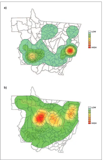
Figure 1 - High and low-priority municipalities for interventions to impact rates of admissions due to pneumonia (a) and to prevent burning (b), Mato Grosso, Brazil, 2008-2009
NS = no significance.
of Mato Grosso (the number per municipality ranged from zero to 2,315 admissions), and 161,785 ire outbreaks were recorded, with a range of seven to 6,454 per municipality. The mean rate of admission per 1,000 inhabitants was 2.89 [standard deviation (SD) = 5.18] and the number of ires per 1,000 inhabitants was 152.81 (SD = 199.91). The overall I for number of admissions was 0.02 (p = 0.26), while for admission rate it was 0.02 (p = 0.21) and for
cluster, i.e., there are groups of neighboring municipalities with similar patterns of numbers of ire outbreaks.
Figure 2 - Choropleths maps for density of rate of admissions due to pneumonia (a) and for ires (b), Mato Grosso, Brazil, 2008-2009
5 to 20 thousand inhabitants; another is in the West, close to the border with the state of Rondônia, and has around 20 thousand inhabitants. Ten municipalities had below-average rates: one in the center of the state, with around 60 thousand inhabitants; nine in the Southeast, close to the borders with the states of Goiás and Mato Grosso do Sul.
The municipalities with the highest priority for interventions to combat burning make up what is known as the arc of deforestation, and low-priority municipalities are concentrated in the Southeast, similar to the pattern for admissions due to pneumonia.
The kernel estimator identiied a hot spot of higher rates of admission at the border between Mato Grosso and Goiás and another lower intensity hot spot in the Southwest of the state, in the direction of Rondônia (Figure 2a). The spatial distribution of the ires was signiicant, and the municipalities with the greatest numbers of events form an arc, which is known as the arc of deforestation (Figure 2b). The Pearson correlation coeficients are listed in Table 1.
Discussion
* p < 0.01.
Cases 0.66 1
Fires -0.29 0.07 1
Admission rate -0.15 0.31* 0.05 1
to pneumonia and also municipalities with high numbers of ire outbreaks in 2008 and 2009.
Pneumonia is a disease with a high rate of lethality; 7.7% of all deaths of children in the age range of 0 to 4 years that occurred in Mato Grosso during the study period had pneumonia recorded as basic cause of death: 150 out of a total of 1,956 deaths.22 It is important to point out that the diseases listed in chapters XVI (certain conditions originating in the perinatal period) and XVII (congenital malformations, deformities and chromosomal anomalies) of the ICD make a major contribution to deaths of infants under 12 months. Notwithstanding, the inancial cost to the state of Mato Grosso of hospital admissions due to pneumonia in this age group was R$ 10 million (1 US$ ≈ R$ 1.80), which was 25% of all spending on admissions of patients in this age group.19
Fires may be natural events or caused by humans which is more likely in the Brazilian Mid-West. They release carbon monoxide and dioxide, methane, particulate material, nitrogen oxides and ozone (this last atmospheric pollutant is created by the action of sunlight on nitrogenated compounds).23 In addition to these pollutants, ires release aldehydes, hydrocarbons, inorganic acids and polycyclic aromatic hydrocarbons which provoke serious clinical manifestations in both adults and children.24
Fires are responsible for more than 70% of Brazil’s carbon emissions.25 Mato Grosso is one of the states with the largest number of ire outbreaks. More than 160 thousand ires were reported in the 2 years studied here (2008 and 2009).
In contrast with a study conducted by Ignotti et al.,13 in this study municipalities were not selected on the basis of high rates of admission due to respiratory diseases nor were only municipalities with more than 25 thousand inhabitants studied. All 141 municipalities in the state of Mato Grosso were analyzed for the study.
One advantage of this study is the use of geoprocessing which allows environmental data to be integrated with health data, improving the deinition and quantiication of exposure
and its possible determinants and harmful effects on health. This methodology attempts to identify plausible associations with the processes of sickness and death in populations within their spatial distribution and social relationships. Towns and cities do not exist in isolation, they are connected to other larger and smaller urban centers and to rural regions with which they establish relationships of exchange. The degree of connectivity and importance of a city generally has an effect on the processes by which diseases spread, i.e. the most-connected towns are reached the fastest.26
The spatial distribution of rates of admission did not exhibit signiicant autocorrelation. In contrast, the ires did exhibit a statistically signiicant spatial distribution; their geographical distribution follows a path from Northwest to Northeast along an arc, with the concavity to the North: the area known as the “arc of deforestation”.
When the admission rates were analyzed using the kernel estimator, there was a region with greater density of municipalities with higher rates (a hot spot) in the east of the state, at the border with state of Goiás, and another, smaller, hot spot in the West, at the border with the state of Rondônia; which is similar to the behavior observed for asthma admissions.25
When the kernel estimator for the ire outbreaks is analyzed, the arc of deforestation is clearly identiiable. In this area ire is used to clear land, both to increase the area under cultivation for agriculture and for grazing livestock raised for meat. Notwithstanding, the regions with the highest densities are to the North of the regions with the highest densities of admissions.
This distribution can be explained by the fact that the pollutants produced by the ires are transported into the troposphere (3 to 10 km high) by convection currents caused by the high temperatures that are created during the laming phase of combustion, where the action of wind can take the smoke and its components a long way from the ire that created it.23
the practice of burning sugar cane ields after harvest increased the risk of diseases of the respiratory system in children and the elderly.3 Burning sugar cane ields during the dry season generates three times as much particulate matter (PM10) and double the black carbon (BC) and elements such as aluminum (Al), sulphur (S), potassium (K) and silicon (Si). There was an increase of around 25% in admissions due to respiratory problems in children, which was attributed to the presence of PM10 and BC released by burning the sugar cane ields.
In the present study, data were not analyzed separately for the rainy and dry seasons. Many more ires are recorded during the dry season (May to October), corresponding to 90% of occurrences.17
The Moran map identiied six municipalities that merit interventions on the basis of high admission rates; four are located in the east, close to the border with the state of Goiás, and have populations ranging from 5 to 20 thousand inhabitants; while another two are in the west, close to the border with Rondônia and to the municipality of Tangará da Serra. This could be an indication that there is an increased demand in Tangará da Serra, that does not originate in the municipality itself, but in neighboring municipalities. One possible reason for this is that Tangará da Serra is a regional center and has good healthcare infrastructure. Many residents of neighboring towns provide ictitious addresses in Tangará da Serra so they can access its health services.
Those municipalities that are classiied as high priority should set themselves the objective of reducing rates to the levels observed in their low or medium-priority neighbors. However, these rates could be linked to the number of ires set 400 km to the Northwest and to their wind-borne components.
The spatial approach made it possible to identify 11 municipalities with below-average rates of admission; nine of them in the Southeast, close to the borders with Goiás and Mato Grosso do Sul. These are municipalities where the priority for intervention is low. They are located more than 600 km from the regions where the density of ires is greatest. On the other hand, one of them is located in the center of the state, has around 60 thousand inhabitants and is bisected by the Cuiabá-Santarém highway. It has a general hospital with 233 beds. These characteristics possibly relect better access to health services which would explain the low admission rates. In a study published by Ignotti et al.,13 this municipality had a low admission rate among a sample of municipalities with more than 25 thousand inhabitants.
The other municipality with low rates is in the metropolitan region of Greater Cuiabá and this geographical location explains its low rates since there is the possibility of easy access to health services and the availability of health professionals.
The city of Rondonópolis is an important regional center and is in the southeast of the state, bisected by the BR-364 highway. It is possible that these facts facilitate better access to health services and the region should have specialists, which makes it possible to reduce admission rates. The municipalities located in this region have low admission rates.
On the other hand, it was to be expected that there would have been a larger number of admissions in the arc of deforestation. One possible explanation for the fact that there were not more admissions could be the dificulty involved in accessing medical attention, whether due to lack of health professionals or due to the distances that have to be traveled between the locations where events occur and the cities. Another explanation could be under-reporting of cases that are coded as some other diagnosis.
Another strong point of this study was the identiication of municipalities with high rates of admissions due to pneumonia, since this allows the number of deaths in this age group due to the disease to be reduced, which is a reduction that is also taking place in the Mid-West administrative region.27
Ecologocal studies tend to have their limitations. Among these is the fact that they use secondary data. The source for the data used in this study, was DATASUS, and several different studies have been conducted with their data.6,12,25 The possibility of diagnostic errors should be considered since the study did not conirm the diagnoses of pneumonia, as was done by Andrade et al.14 in Goiânia. Other limitations would include over diagnosis and the provision of incorrect residential addresses for the children admitted, increasing admission rates.
The results presented here are a quantitative estimate of the impact of atmospheric pollution on a population’s health. It is important to bear in mind that the outcome studied here - hospital admissions - is just one of the many effects of air pollution. This study employed secondary data to calculate coeficients of admissions due to increased atmospheric pollution.
References
1. Brasil, Ministério da Saúde. Cadernos de Informação de Saúde. Departamento de Informática do SUS - DATASUS. http://tabnet. datasus.gov.br/tabdata/cadernos/cadernosmap.htm. Access: 25/02/2011.
2. Farhat SC, Paulo RL, Shimoda TM, Conceição GM, Lin CA, Braga AL, et al. Effect of air pollution on pediatric respiratory
emergency room visits and hospital admissions.Braz J Med Biol Res. 2005;38:227-35.
3. Cançado JE, Saldiva PH, Pereira LA, Lara LB, Artaxo P, Martinelli LA, et al. The impact of sugar cane-burning emissions on the respiratory system of children and the elderly. Environ Health Perspect. 2006;114:725-9.
4. Schwartz J. Air pollution and children’s health. Pediatrics. 2004;113:1037-43.
5. Cançado JE, Braga A, Pereira LA, Arbex MA, Saldiva PH, Santos U de P. Clinical repercussions of exposure to atmospheric pollution. J Bras Pneumol. 2006;32:S5-11.
6. Nascimento LF, Pereira LA, Braga AL, Módolo MC, Carvalho JA Jr. Effects of air pollution on children’s health in a city in Southeastern Brazil. Rev Saude Publica. 2006;40:77-82.
7. Ignotti E, Hacon S de S, Junger WL, Mourão D, Longo K, Freitas S, et al. Air pollution and hospital admissions for respiratory diseases in the subequatorial Amazon: a time series approach. Cad Saude Publica. 2010;26:747-61.
8. Pope CA 3rd, Dockery DW. Health effects of ine particulate air pollution: lines that connect. J Air Waste Manag Assoc. 2006;56:709-42.
9. Braga AL, Saldiva PH, Pereira LA, Menezes JJ, Conceição GM, Lin CA, et al. Health effects of air pollution exposure on children and adolescents in São Paulo, Brazil. Pediatr Pulmonol. 2001;31:106-13.
10. Tan WC, Qiu D, Liam BL, Ng TP, Lee SH, van Eeden SF, et al. The human bone marrow response to acute air pollution caused by
forest ires. Am J Respir Crit Care Med. 2000;161:1213-7. 11. Sapkota A, Symons JM, Kleissl J, Wang L, Parlange MB, Ondov J, et
al. Impact of the 2002 Canadian forest ires on particulate matter air quality in Baltimore city. Environ Sci Technol. 2005;39:24-32.
Siqueira Júnior JB, et al. Population-based surveillance of pediatric pneumonia: use of spatial analysis in an urban area of Central Brazil. Cad Saude Publica. 2004;20:411-21.
15. Mukai A de O, Alves K de S, Nascimento LF. Spatial analysis of hospitalizations for pneumonia in the Vale do Paraíba region of Brazil. J Bras Pneumol. 2009;35:753-8.
16. Williams BG, Gouws E, Boschi-Pinto C, Bryce J, Dye C. Estimates of world-wide distribution of child deaths from acute respiratory infections. Lancet Infect Dis. 2002;2:25-32.
17. Brasil, Ministério da Ciência e Tecnologia, Instituto Nacional de Pesquisas Espaciais. Queimadas: monitoramento de focos. http:// www.dpi.inpe.br/proarco/bdqueimadas/. Access: 06/06/2011. 18. Brasil, Ministério da Ciência e Tecnologia, Instituto Nacional de
Pesquisas Espaciais. Projeto TerraView. http://www.dpi.inpe.br/ terraview/index.php. Access: 04/06/2010.
19. Brasil, Ministério da Saúde, DATASUS: Informações de saúde. Morbidade Hospitalar do SUS - por local de residência - Mato Grosso. http://tabnet.datasus.gov.br/cgi/deftohtm.exe?sih/cnv/ nrmt.def. Access: 15/02/2011.
20. Brasil, Instituto Brasileiro de Geograia e Estatística. Índice de pastas. ftp://geoftp.ibge.gov.br/mapas/. Access: 06/06/2011. 21. Brasil, Ministério da Ciência e Tecnologia, Instituto Nacional de
Pesquisas Espaciais. Análise Espacial de Dados Geográicos. http:// www.dpi.inpe.br/gilberto/livro/analise/. Access: 23/09/2011. 22. Brasil, Ministério da Saúde, DATASUS: Informações de saúde.
Mortalidade - Mato Grosso. http://tabnet.datasus.gov.br/cgi/ tabcgi.exe?sim/cnv/obt10mt.def. Access: 23/09/2011. 23. Freitas SR, Longo KM, Dias MA, Dias PL. Emissões de queimadas em
ecossistemas da América do Sul. Estud Av. 2005;19:167-85. 24. Arbex MA, Cançado JE, Pereira LA, Braga AL, Saldiva PH.
Queima de biomassa e efeitos sobre a saúde. J Bras Pneumol. 2004;30:158-75.
25. Silva PR, Rosa AM, Hacon SS, Ignotti E. Hospitalization of children for asthma in the Brazilian Amazon: trend and spatial distribution.
J Pediatr (Rio J). 2009;85:541-6.
26. Brasil, Ministério da Saúde, Secretaria de Vigilância em Saúde. Fundação Oswaldo Cruz; Simone M. Santos, Christovam Barcellos, orgs. Abordagens espaciais na saúde pública. Brasília: Ministério da Saúde; 2006. 136 p. (Série B. Textos Básicos de Saúde. Série Capacitação e Atualização em Geoprocessamento em Saúde; vol. 1).
27. Rodrigues FE, Tatto RB, Vauchinski L, Leães LM, Rodrigues MM, Rodrigues VB, et al. Pneumonia mortality in Brazilian children aged 4 years and younger.J Pediatr (Rio J). 2011;87:111-4.
Correspondence:
Luiz Fernando C. Nascimento Rua Durval Rocha, 500 - Vila Paraíba CEP 12515-710 – Guaratinguetá, SP – Brazil Tel.: +55 (12) 3625.4271
E-mail: luiz.nascimento@unitau.br is measured ecologically, it is assumed that a variation in
the average level of pollution on a given day in a given municipality also relects a variation in the average exposure of each person that lives there.