Project 495
Quaternary Land-Ocean Interactions:
Driving Mechanisms and Coastal
Responses
th4 annual conference - Algarve, Portugal
th st
27 October - 1 November 2008
Field Guide
Centro de Investigação Marinha e Ambiental
Universidade do Algarve, Faro, Portugal
Comission on Coastal and Marine Processes
ORGANISING COMMITTEE
CIMA – Centro de Investigação Marinha e Ambiental, Universidade do Algarve
Tomasz Boski
Delminda M. de Jesus Moura Duarte Nuno R. Duarte João M. A. Dias, Cristina Veiga-Pires, Óscar Ferreira
Sarita Camacho da Encarnação
Graphical editing: Carlos Souza & Laura Pereira Secretary of the meeting: Zélia M. Coelho
Centro de Geologia, Faculdade de Ciências, Universidade de Lisboa
Maria Conceição Freitas César A. Andrade
Centro de Estudos Geográficos da Universidade de Lisboa
Ana Ramos Pereira
Quaternary Land-Ocean Interactions: Driving Mechanisms and
Coastal Responses
IGCP 495 Fieldtrip
Algarve and Alentejo, Portugal
30th October – 1st November 2008
FIELD GUIDE
Edited by :
Tomasz Boski and Sarita C. da Encarnação
CIMA – Centre for Marine and Environmental Research
Universidade do Algarve
International Geological Correlation Program
Project # 495
Remissive Index
Day 0 – 28 October
STOP I - Falésia – Garrão Coastal Stretch………1
Day 1 – 30 October
STOP I - The barrier system of Ria Formosa. Faro-Olhão Inlet and Culatra Island……...5 STOP II - Cacela Velha………..15
Tomasz Boski
STOP III – Guadiana Estuary. Panorama from Castro Marim Castle and visit to the river mouth………....21
Tomasz Boski, Sarita C. Encarnação and Delminda Moura
Day 2 - 31 October
STOP I – Pleistocene platforms cut into Miocene rocks……….34 a - Olhos de Água……….34 b - Galé – S. Rafael………...37
Delminda Moura
STOP II – Tsunamis deposits and the history of Lisbon tsunamis. Boca do Rio…………40
César Andrade and Maria Conceição Freitas
STOP III – Aeolianites deposited on rocky coast. Cape Sagres……….46
Day 3 – 1 November
STOP I – Infilled estuarine valley. Mira Estuary, Vila Nova de Mil Fontes………..48
César Andrade, Maria Conceição Freitas, Tomasz Boski and Sarita C. Encarnação
STOP II – Coastal sands deposited on an elevated Pleistocene platform. Aivados………55
Ana Ramos Pereira
STOP III – Geomorphology of the littoral platform. Ilha do Pessegueiro……….59
Ana Ramos Pereira
STOP IV – Holocene history of Lagoa de Sto André coastal stretch……….69 a - Poços de Barbaroxa dunes
b - ICN facilities in Sto André.
S 1 3 2 Alga Guad The comp Creta and silici Basin unde shelf switc to the 3 The G 150 chan The bord from and h STOP III - 1. Geograp 37º 10’ 19’’ 2. Regiona arve present diana Estuar Hercynian posed of sh aceous form limestones iclastic sedi n started to er E-W to E f has been s ching from e accumulat 3. Local ge Guadiana R km of the m nnel forming drainage ba ers while 83 m 400 to 600 hot. Conseq Guadiana E phical coor ’ N; 7º 23’ 5 al geologica ts very con ry (Fig.1). Serra in t hales and gr mations, com . The sou iments resp o form in th ENE-WSW shaped sinc carbonate r tion of tens eology and River flows main river g the border asin area is 3% (55,364 0 mm, but a quently, the Estuary rdinates: 50’’ W al setting: nspicuous g the North reywackes. mposed ess uthward litt pectively da he Late Tria W distension ce the Neog reef to terrig of meters o hydrograp 810 km fro and many r between th 66,889 km 4 km²) is in a clear seaso e river flow geological z which belo The centra sentially of toral fringe ated from M assic during nal regime. gene. The s genous sedi of sands and phy: om its headw longer tribu he two coun m², of which Spain. The onality is ty varies seas zoning, whi ongs to the al zone is o red sandsto e is domin Miocene an g the early The presen shelf evolut imentation, d silts which waters in Sp utaries in P ntries. h just 17% ( e mean year ypical, with sonally, from IGCP#495 -ich is prese e Hesperic occupied by ones and co nated by c nd Plio-Ple phase of N nt morpholo tion since th in semi-gra h were seen pain to its m Portugal, an (11,525 km rly rainfall i h summer m m 200–600 2008 Field G ent also in Massif is y Triassic, J onglomerate clastic lime eistocene. T North Atlant ogy of the he Tortonia aben structu n in Cacela. mouth in Po nd 110 km m²) is inside in the basin months usua m3s-1 durin Guide the area o essentially Jurassic and es, dolerites estones and The Algarve tic opening continenta an, involved ures, leading ortugal, with of the main Portuguese n area varies ally very dry ng winter to 21 f y d s d e g, al d g h n e s y o
0.1–2 year Figur 20 m3s-1 in to year, var re 1. Geologi summer. In rying from 2 ical setting o n addition, s 20×108 m3 i of Guadiana E significant f in a dry yea Estuary with fluctuations ar to 800×10 h the localiza IGCP#495 of river inf 08 m3 in a w ation of majo 2008 Field G flow are ob wet year. r boreholes m Guide served from marked by * 22 m .
The perm tidal is 70 days in th high The l defin so na from the H paleo degla estuary has manently op regime of t 0 days, but i . The Guad he river is l flow in win low permea ned the mor
arrow and d m the mouth. Hercynian b ovalley wh aciation, is Figu s a maximu pen, and flo
the estuary in the lower diana estuary ow, the est nter and spr ability and t rphology of deep: 600 m . On the we basement is hich was p shown in th ure 2. Pre-inu um width of ows continu is meso-tid r estuary an y can be co tuary becom ring, stratific tectonic frac f river paleo m wide and estern Portu s covered b progressivel he Fig. 2. undation mo f 550 m and uously, apar dal, with ave nd during th onsidered as mes vertical cation can o cturing of th ovalley. In f d over 80 m uguese marg by the Juras y drowned orphology of d a depth v rt from ann erage ampli he rainy sea s partially st lly homoge occur. he Paleozoic fact it is quit m deep belo gin of the es ssic carbona d and sedim the area of G IGCP#495 -varying betw nual and se itude of 2 m ason, reside tratified. Ho neous, whe c basement te unique in ow mean se stuary the in ate rocks. T ment infill Guadiana Riv 2008 Field G ween 5 m a easonal vari m. Mean res ence time m owever, wh ereas during shales and n South Iber a level ca 7 ncision is le The morpho ed followin ver Estuary. Guide and 17 m, is iations. The sidence time may be of 10 hen the flow g periods o
greywackes ria by being 7 km inland ess deep and ology of the ng the las 23 s e e 0 w f s g d d e t
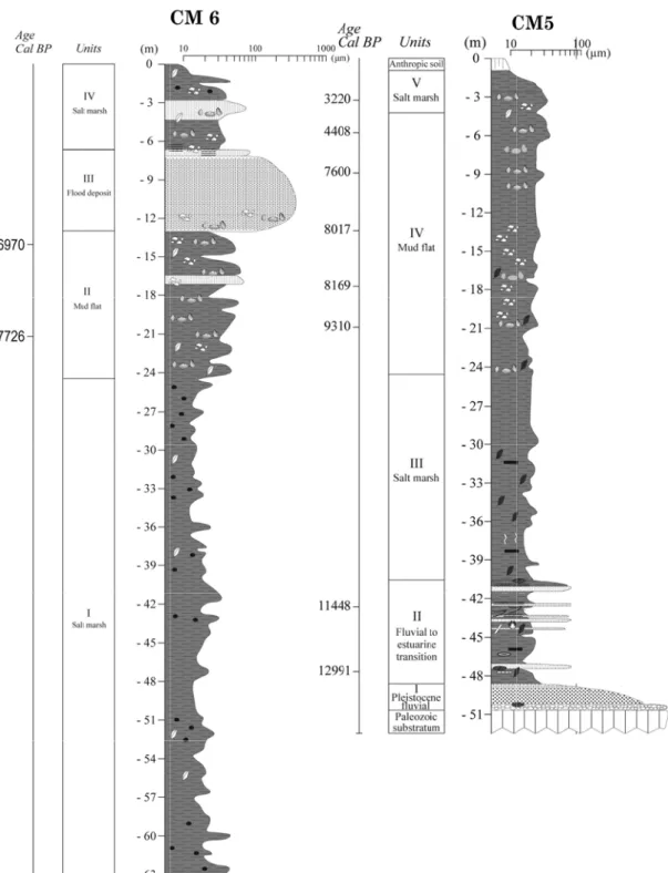
The destr is sh The g Figur pre-transgre ructive, perc hown in Fig generalized re 3. Litholog CM1 CM2 ession surfa cussion bor g. 1 and 2 a d cross secti gical profiles
ace was rec reholes, the and the resp
on through s in borehole constructed seismic pro pective litho the valley i es CM1 to CM by triangul ofiling and ological pro infill is show M4. IGCP#495 -C lation using 6 cored bor ofiles are res wn in the Fi C 2008 Field G CM3 g the data f reholes who sumed in F ig. 7. CM4 Guide from tens o ose location Fig. 3 and 4 24 f n 4.
Figure 44. Lithologiccal profiles inn boreholes C IGCP#495 -CM6 and CM 2008 Field G M5. Guide 25
Notw obser boun depth the l balls conti occa form rise i by th tidal brack Num In bo exclu the s disco perio Bosk this u of w whic Sedim homo chan the sedim withstanding rved in bo ndary in the h. It separat ower mostl , and freq inuous influ sional supp mations crop in the corre he salt mars flooding. T kish/fresh w merous trace orehole CM usively of c south, occu ontinuity w od of depos ki, 2000) wh unit is latera well preserv ch were men ments drille ogeneous fa nnel lags. Th central estu ment, accou g the obse oreholes CM e approx. 70 tes a sequen ly clayey, b quent flaser uence of tid ply of mate pping out al sponding p sh vegetatio The reporte water cond s of rootlets M2, the princ clay deposit upied at pr ithin this u sition i.e. si hich were d ally homoge ved valves ntioned abov ed between acies of clay hese facies uarine bas unt for almo
erved litho M1 and CM 000 yr. Cal nce of rhyth bioturbated r structures dal currents erials rich i long Algarv eriod, the fi on which its ed discrete ditions whi s indicate th cipal, clayey ted in a con resent by M unit indicate ince ca 790 done over th enous, comp of Cerasto ve. n 31.2 m a ys, very ric are typical in where ost 100% of ological dif M3 record BP, respect hmic fining facies. In t s points to s. Reddish in ferrugino ve-Andaluzi fine sedimen self could m centimetre-ich most p hat these pat
y unit is inte nfined lagoo Monte Gord es that thes 00 yr. Cal B he surface of posed entire oderma edu and 16.5 m ch in vegeta l for confin agglutinated f the entire a fferences, t ed two dis tively. In C up series in the latter, d o upper in clayey laye ous pigmen ia coasts. L nt load coul maintain a c -scale peaty probably oc tches of pea erpreted as on environm do dune fie e condition BP. The 30 f about 1km ely of claye ule, Ruditap in borehol al remains w ned marshes d foramini assemblage. IGCP#495 -the Holoce stinct sedim CM1 the bou nterpreted as dissipated v ntertidal fla ers observe nts, eroded Likewise, du ld be effecti constant pos y levels indi ccurred in at are in situ an upper m ment shelte eld. The la ns prevailed 0 hand auge m2 around C ey–silty sedi pes decussa le CM3, be with some b s developed ifera specie . The two 14 2008 Field G ene sedime mentary fac undary is se s point bar vegetal fragm at environm ed in this u from Plio-ue to the fa ively trappe sition in rel icate the re semi-confi u. marsh, comp red by the ack of any d throughou er drillholes CM2, have s iments encl atus and ot elong to a bioclastic de d within the es depende 4 C dates so Guide entary infil cies with a et at 16,2 m facies, from ments, mud ment, under unit indicate -Plesitocene ast sea leve ed and fixed lation to the ecurrence o ined ponds osed almos sand spit to observable ut the entire s (Santos & showed tha losing levels ther species remarkably eposits from e reaches o ent on fine far obtained 26 ll a m m d r e e l d e f s. t o e e & at s s y m f e d
(947 sea l are m incre intert when datin an im al. (1 coast Of th comp lamin from Cadi attrib IS III in pr BP a nece bar o are b thus The conta been level 0 yr. BP at evel at an a mostly fine easing tidal tidal level s n the sea lev ng of the sub mportant co 1994) in tha ts began, wh he 4 cores c plex. Two b nated and m presence o z, in the E buted to the I highstand redominantl at -15.2 m, ssary reserv or one high barren of an their depos The sedim chronologic aining wood n observed a l before the 26.9 m an accelerated e sand with energy. Th species, as i vel rise bec bmerged ro omponent of at period th hich enable considered, basal grave hardened d of carbonat Estuaries of e highstand (Dabrio et ly sandy the 6437 yr. c ves imposed energy eve ny fauna at m ition occurr mentary prof cally resolv d fragments at this level second dat d 7080 yr. pace of 0,6 h frequent c he observed it happened came faster ocky shore r f the estuari he first phas ed the enclo the sedime el units encl deposit whi te nodules a f Tinto-Od ds during th al., 2000), e shell rich, cal BP at -9 d by the hig nt which le macro- and red in a sub ofile of Belic ved sedimen s dated 129 l. However ted level, at BP at 14.52 6–1 m per c channel lag d replaceme in our case than marsh ridges on A ine infill be se (H1) of b sing of Ria ntary colum lose the sal ich experien and oxidize diel and Gu he isotope st ca. 25-30 k gravel laye 9.75m and ghly dynam ed to rework d microscop aerial envir che Rivulet ntary record 991 yr cal. r, intertidal t 42.70 m, w 2 m) point century. Lith gs, indicatin nt of the up e around 85 h accretion. lgarve shelf etween 7500 barrier prog Formosa. mn of the C lt marsh sed nced prolon ed levels. F uadalete Ri tage (IS) V ka. The first
er at 15.2 m d 7159 yr. c mic environm
king of mate pic scale and ronment of t t – Borehole d in boreho BP, at 47.6 foraminifer with an age IGCP#495 -once more hofacies fro ng a shift t pper marsh 00 yr. cal B Combining f suggests th 0 yr cal BP gradation al M4 boreho diments ov nged subae Further to th ivers the si , ca 128 ka evidence o m. The existi cal BP at – ment) rapid erial. The u d contain ab the coastal d e CM5: ole CM5 be 67 m depth ra do occur of 11448 y 2008 Field G to conditio om 16.4 to to the envi foraminife BP. must ha g these figu hat shelf sa P. According long the Gu le is certain erlain by sw erial exposu he west in imilar sequ (Zazo, 199 f marine se ing datings –7m point d accretion uppermost 3 bundant flo dune system gins with a h; no forami r in above t yr. cal BP. T Guide ons of rising 1.5 m depth ironment o era by lower ave occurred res with the ands became g to Zazo e ulf of Cadiz
nly the mos wamp/creek ure inferred the Gulf o uences were 99) or to the dimentation 7208 yr. ca to (with al of a coasta 3 m of sands ral remains m. a silty layer inifera have the 47.67 m Therefore to 27 g h f r d e e et z t k d f e e n al l al s s, r, e m o
that, trans disco Estua the R whic boreh cal. B m pe rema supp The carbo unit h The l intert by th there From scarc unit vege segm stage reple which in sitional fluv ontinuity in ary without Ria de Vigo ch can be at hole CM5 o BP and 760 er century w arkably con orting the r overlying h onate shell, had been an local chang tidal level w he first app efore at 24.5 m this level city or absen from 24.5 tated mud f ment is a cle e, condition enished duri chronostra vial/marine lithology, t any major o, Galicia, ttributed to on the Guad 00 yr. cal. B with a squa nstant sedim egional sea horizon, wh , datable ite n intertidal s ge of the sed with little o pearance of 5 m depth i. upwards, t nce of plant to 4.2 m flat borderin ear signal fo ns are favo ing the sprin
atygraphical origin ma it may be a interruption Spain, seis the Young diana Estua BP, comprisi ared correla ment accretio level drop hich extend ems. Never salt marsh e dimentary fa or no haloph f macrofaun e. the first a he continuo t root traces depth had ng the Beli or the termin ourable for ng tides and l terms co ay be attri assumed tha n in sedime mic reflecti ger Dryas st ary, the dept ing six date ation coeffi on rate and during the Y ds to the de rtheless, the environmen facies from t hyte vegetat na. The lim appearance ous presenc s and other v d been depo iche channe nal stage of the format d subsequen orresponds ibuted. Giv at this trans entation. Ind ion profiles tadial (Garc th-age relat ed points, fit icient R2=0 d consequen Younger Dr epth of 24.5 e foraminife t. the upper (s tion coverin mit between of bivalve S ce of macro vegetal rem osited as a el. The appe f sediment i
tion of sma ntly subject
IGCP#495
-to the Yo ven the lac
sition occur deed, at a si s, also show cía et al., 20 tion for the
ts a linear r .971. This ntly, we do ryas. 5 m provide era assembl salt-marsh) ng the sedim n these two Scrobicular o and micro mains, indica a non-veget earance of g infilling wit all water p to desiccati 2008 Field G ounger Dry ck of any rs within th imilar depth w a clear d 005). More period betw regression tr correlation not find an es neither o lage indicat to the lowe ment surfac o lithofacie ria Plana. ofossils, com ate that the s
tated or ve gypsum in thin the estu ponds, whic ion. Guide yas (YD) a observable he Guadiana h of 45 m in discontinuity eover, in the ween 12991 rend of 0.73 points to a ny evidence organic, nor tes that this
er (mud flat) ce is marked es is placed mbined with sedimentary ery scarcely the topmos uary. At this ch could be 28 a e a n y e 1 3 a e r s ) d d h y y t s e
The unit. with This chan basem depth How profi foram the h apog Amon lobat sp. F foram The supp Mora l06 m mean (Bos the p grow progr final uppermost Microfaun the halophy The Boreh borehole w nnel axis. T ment. At 63 h. There w wever, throu ile (Boski minifera at 6 horizon the m gee of the H nia beccari tulus, Plano From that minifera fau Recent ge present mo lied and dr ales (1997) m3 of sedim n accumulat ki, 2002) v progradation wth of the M radation oc stage of in part of the na indicates yte salt mar
hole CM6: was drilled There is ab 3 m depth st as a compl ugh the com
et al., 200 63 m depth, marine influ Holocene tr ii and Hayn orbulina me depth upw una. eological fe orphology o rifting shelf estimated t ment have a tion rate of volume of lo n occurred i Monte Gord ccurred as n nfilling of e profile ha confined en rsh vegetatio recently an bout 7 m tarts an enti lete lack of mparison w 08) we ma , must date uence is inc ransgression nesina germ editerranen wards the l atures of co of the Gua f sediments that since m accumulated 500 x l03 m ongshore dr in a differen do Beach sp new barrier the embay s much les nvironment on covering nd is the de of coarse irely silty- f f datable ite with a well ay assume back to a pr creasing to i n ca 6970 manica asso sis, Asterig lithological oastal chan adiana Estua s being dep mid-Holocen d on a area m3/yr. This f rifting sand nt way on ei pit took plac islands form yment accom s macrofau t in the fina g the sedime eepest one gravel dep fine sand/sil ems from t established that fully revious mar its maximum yr. cal BP ociated to th gerinata ma column h nge: ary is a re osited acco ne stabilizat of 10.5 km figure is app . Figures 5 ither sides o ce on the w med from a mmodating IGCP#495 -una preserve al stage of i ent surface. due to its osited dire lty horizon the base up d age mode marine co rine highsta m at 13.2 m P. The dom he shelf for milla, Briza has variable sult of acc ording the t tion of the s m x 7 km ( proximately and 6 (Mo of the estua western side, active sand present es 2008 Field G ed than the infilling of proximity t ctly on the which exte pwards to 2 el of the n nditions, in and. Toward m depth, cer minant foram rms, namely alina sp. an e texture w cumulation tidal and w sea level, ab (73.5 km), i y triple of th rales, 1997 ary mouth. A , while on t bars. It see stuary could Guide e underlying the estuary to the main e Paleozoic nds to 17 m 24 m depth nearby CM5 ndicated by ds the top of rtainly at the minifera are y: Cibicides nd Discorbis with a rich of fluvially wave energy bout 2490 x indicating a he estimated ) show how A transverse the east, the ems that the d be well a 29 g y, n c m h. 5 y f e e s s h y y. x a d w e e e a
cons Fletc sourc intert side sedim prom artifi erosi equence of cher et al. ces was an tidal flats. of the estua ment supply minent is A icial lake in ion. f anthropic (2007), in n island in At present ary by the j y is close to Alqueva. It n Europe. A activities, m the Middle Roman Ti moment th etty which o nil becaus was effecti As a result mainly defo e Holocene imes and d he sand drif was termin se of retenti ively closed the eastern orestation, w . Castro M during the ft from the ated in 197 ion behind d in 2002 n part of th Figu year Oje IGCP#495 -which was Marim, acco Middles A east is stop 4. From the ca 50 dams and forme he Guadiana ure 5. Recon rs of Guadia da (1988). 2008 Field G initiated, a ording to th Ages was e pped on the e other hand s, from whi d since the a delta is u nstruction of ana Estuary Guide according to he historica encircled by Portuguese d the fluvia ich the mos en a larges under severe the last 3000 according to 30 o al y e al t t e 0 o
IGCP#495 - 2008 Field G Figure 6. T years of Gu Estuary acc Morales (1 Guide The last 200 uadiana cording to 997). 31
Figu data Ref Bosk Bosk Dab Fletc Garc Mor Ojed ure 7. Interpr a for internati ferences: ki T., Mour Santana, Estuary, ki, T., Cama Loureiro postglac Estuarin brio, C. J., Za (2000) – Cadiz, S cher, W.J., B changes 17, 481 cia-Garcia, A Marine G rales, J.A., 1 (S.W. Sp da, J., 1988 Geomor 411pp. ( retative geolo ional bridge ra, D., Cam , P., 2002. P , Portugal/Sp acho, S., Mou o, C., Santan cial sea level
ne Coastal an azo, C., Goy – “Depositio Southern Spa Boski, T., Mo in the lower – 494. A. Garcia-G Geology 220 1997. Evolut pain – Portug 8. Aplicacio rfologia y Or (unpublished ogical profil project. macho, S., D Postglacial s pain border. S ura, D., Fletc a, P.(2008)– rise in two e nd Shelf Scie y, J. L., Sierr nal history o ain)”. Marine oura D., 200 r Guadiana v Gil, S., Vilas, 0, 153-179.
tion and fac gal), Marine ones de la t rdenacion de d). e A-A’ – Gu uarte, R.D.N ea level rise Sedimentary cher, W., Wil –Chronolog estuaries of th ence, 77 : 230 ro, F. J., Borj of infill durin e Geology, 16 7, Palynolog valley (Portu F.,2005. Qu cies architec Geology, 13 teledeteccion e1 Territorio. IGC uadiana estua N., Scott, D e and sedime y Geology 15 lamowski, A y of the sedi he Algarve c 0 – 244. rja, F., Lario ng the last p 62, pp. 381-4 gical evidenc ugal) during uaternary evo ture of the 38, 127 – 148 n espacial a . Ph.D. Thes CP#495 - 2008 ary, based on D.B., Veiga-P entary respo 50, 103-121. A., Veiga-Pire imentary pro coast, Southe , J., Gonzále postglacial tra 404. ce for environ the last 13,0 olution of the mesotidal G 8. a la dinámi sis, Universit 8 Field Guide n destructive Pires, C., Pe nse in the G es, C., Corre cesses durin ern Portugal.
ez, A. & Flor ansgression nmental and 000 years. H e Ría de Vigo Guadiana Riv ica litoral ( ty of Sevilla, e drilhole edro, P., Guadiana eia, V., g the res,J.A. (Gula of d climatic Holocene. o, Spain. ver delta Huelva), , Sevilla, 32
Sant
Zazo
Zazo
tos, A., Bosk contraste editors. o, C., 1999. I –113. o, C., Goy, J Silva P. Trends i 94. ki, T., 2000. ed sediment Eurocoast A Interglacial s J. L. , Somoz G., 1994. H in the Atlant The compa tary dynamic Association P sea levels. Q za, L., Dabrio Holocene Se tic - Mediterr arison of Hol c of Guadia ortugal, Lisb Quaternary in o,C.J. , Bellu equence of S ranean Linka IGC locene sedim ana Estuary. boa., 53 – 64 nternational, Q uomini, G., I Sea Level flu age Coast. J CP#495 - 2008 mentary infil Carvalho S . Quaternaly I Improta S., L uctuations in ournal of Co 8 Field Guide l in the two S.G., Gomes International Lario , J., Ba n relation to oast. Res. 10 areas of s V. M., , 55, 101 ardaji, T., Climatic 0,4, 933 - 33