Conference Paper
Automated Weed Detection Systems: A
Review
Saraswathi Shanmugam, Eduardo Assunção, Ricardo Mesquita, André Veiros, and Pedro D. Gaspar
University of Beira Interior, Covilhã; Centre for Mechanical and Aerospace Science and Technologies (C-MAST), Covilhã
Abstract
A weed plant can be described as a plant that is unwanted at a specific location at a given time. Farmers have fought against the weed populations for as long as land has been used for food production. In conventional agriculture this weed control contributes a considerable amount to the overall cost of the produce. Automatic weed detection is one of the viable solutions for efficient reduction or exclusion of chemicals in crop production. Research studies have been focusing and combining modern approaches and proposed techniques which automatically analyze and evaluate segmented weed images. This study discusses and compares the weed control methods and gives special attention in describing the current research in automating the weed detection and control.
Keywords:Detection, Weed, Agriculture 4.0, Computational vision, Robotics
1. Introduction
Modern agriculture is becoming more reliant on computer-based systems. Various technical advances have opened new possibilities to gather information and use it in agriculture as well as in other subjects. Agriculture may not have traditionally been the first to implement the latest discoveries in technology, however, precision agriculture with localization such as Global Positioning System (GPS) and other information tech-nologies are becoming everyday tools for farmers. Automated machines are starting to take over tedious tasks formerly performed only by humans.
Economic and ecological benefits are the driving forces to implement new methods into agriculture. Balancing efficient farming and preservation of nature has traditionally been difficult. Technologies for agricultural tasks help farmers to log their actions, make better decisions and automate activities for faster and more economical execution, while saving energy and reducing the amount of chemicals used.
Corresponding Author: Saraswathi Shanmugam [email protected] Received: 26 November 2019 Accepted: 13 May 2020 Published: 2 June 2020
Publishing services provided by Knowledge E
Saraswathi Shanmugam et al. This article is distributed under the terms of theCreative Commons Attribution License, which permits unrestricted use and redistribution provided that the original author and source are credited.
Selection and Peer-review under the responsibility of the ICEUBI2019 Conference Committee.
Agriculture has yet to see fully autonomous vehicles in wider commercial use, but time consuming and straining tasks have been the first to be allocated plenty of research resources. These tasks include cultivation, planting, weed control and harvesting.
Environmentally conscious farming is rightfully in high demand and this is exactly where new technologies can offer solutions. The current and ever-growing market for organic produce in the UK in 2004 was some £1.2 billion or 1.05% of the grocery market. The same figure in the whole world was £15.5 billion [1]. Organic food production can be promoted on the basis of several benefits; healthier food, improved farming environment and contribution to the rural economy. Organic farms have even out-performed the non-organic farms in mean sales values per hectare in one particular study [2]. New weed control methods and agricultural technologies are required to fulfill the demands of continuously increasing organic production volumes.
Precision agriculture is a term used for agricultural systems that exploit some of the new technological advancements in agricultural site-specific management. Applications of precision agriculture include variable-rate spraying, automated row following for harvesters, mapping of weed patches and crop yield management [3]. Minimizing and making the use of chemicals as effective and non-disturbing as possible is the objective with many new technologies used in agriculture. Ultimately the goal could be to stop the use of chemicals completely.
According to [4], there are three basic types of information required in precision agriculture. These are information on seasonally stable conditions (e.g. annual yield and soil based properties), information on seasonally variable conditions (e.g. weed infestations and weather) and information required to diagnose, find cause and develop strategies for crop management. An imaging system has potential to provide information for all three categories. The different variables that can be measured include water conditions in soil [5], crop yields [6] and weed populations [7]. This information can then be used to target soil and weeds locally, determine the additional nutrient needs and vary the seed rate depending on the soil conditions [8].
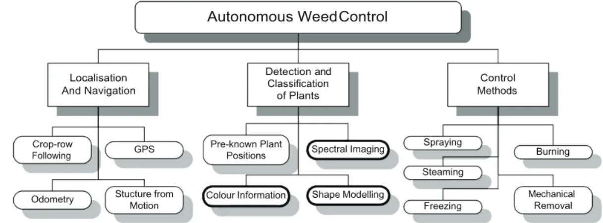
After an extensive literature survey, an agricultural task of autonomous weed control has been divided into three main problems. They are localization and navigation of the machine or implement, detection and classification of plants and weed control methods, as shown in Figure 1. Figure 1 also shows some examples of sub-tasks under the main three problems. The sub-tasks with the bold outline are the ones that this research concentrates on. Although the problem of building a working autonomous weed controlling device is not limited to the three problems presented, one must still solve at least one sub-task from each of the three problems for success.
Autonomous WeedControl Localisation And Navigation Detection and Classification of Plants Control Methods Crop-row Following GPS Pre-known Plant
Positions Spectral Imaging
Spraying
Burning Steaming
Odometry Stucture from Motion
Colour Information Shape Modelling
Freezing
Mechanical Removal
Figure 1: Examples of tasks involved in autonomous weed control.
There are two different approaches to automatic weed control; mapping (off-line) and real- time (on-line) control. In the mapping approach the weed locations (or plant locations) are first mapped and then the spatial distribution information is used with an appropriate control method. This approach is illustrated in Figure 2(a). Mapping of weeds is done prior to actual control actions and weed maps are used later on to apply appropriate control methods to specific locations. GPS position measurements can be used in mapping applications.
The real-time approach illustrated in Figure 2(b) is more demanding in terms of computer processing power. Control methods need to be applied almost instantly after detection and there is limited time for measurement analysis. Operating speeds of many current systems are still below the economical threshold level due to the strict time limits in analysis. The most obvious benefits of the real-time approach over the mapping approach are in the potential to save time and energy as both detection and control are done simultaneously and the field is required to be covered only once. Control methods in both approaches can vary from uniform herbicide spraying to precise mechanical removal of weeds.
Weed detection methods almost always involve some kind of an optical system. Monochrome, color and spectral cameras have been used to gather information for plant classification. Research projects until now have used a variety of spatial and spectral resolutions utilizing only one imaging technology at a time. The common camera sensor technologies of Charged Coupled Device (CCD) and Complementary Metal–Oxide– Semiconductor (CMOS) are in use in almost all fields of imaging research. This also applies to agriculture, although applications may have their unique way of using a particular sensor. Passive and non-intrusive nature of imaging makes it suitable for numerous tasks.
(a) Mapping approach in weed control
(b) Real-time approach in weed control.
Figure 2: Mapping and Real-time approaches in weed control (Reproduced from Vrindts [29])
As seen in Figure 1, an automatic weed control system cannot operate without a solu-tion to all three problems (navigasolu-tion, weed detecsolu-tion and control). Mobile robots have great potential to offer a platform for such solutions. There is a vision that autonomous mobile robots will gradually take over tasks typically performed by humans and it has been suggested that mobile robots could be an economical solution for the particular application of autonomous weed control [9]. There are numerous obstacles in creating autonomous robotic systems for agriculture.
Harsh, ever changing outdoor weather conditions and uneven surfaces are just some examples of problems such systems will face. Despite these obstacles, automation in agriculture is inevitable and desirable. Sensible automation can create immediate ecological and economical improvements in agriculture and crossing the conventional boundaries of scientific research areas is needed to achieve these improvements. The effects of successful research on agricultural automation have local and global effects, such as reduced chemical levels in food produce and increases in production volumes without sacrificing environmental values. These effects are well worth pursuing.
2. Need for Automatic Weed Detection
Automatic and efficient weed control in a real environment requires robust detection of crop and weed. There are several ways of gathering this information from manual
human input to automatic recognition systems. For an economically viable system, automatic recognition and classification is the only solution. The two automatic weed control approaches, as explained in Figure 2, are mapping and on-line methods. In mapping method the locations of weeds can be mapped for example with the help of a GPS signal and treated afterwards. In on-line method the detection and control happens seamlessly at the same time.
Weed detection and prevention can already begin before planting. Weed seeds could be recognized and removed, minimizing the growth of unwanted plants [10]. However, the remaining weed detection methods explained in this paper are meant solely for the post- emergence stage.
Research on automatic detection systems started in the 90’s and was influenced by the need to create systems that would allow significant reductions in herbicide volumes. More or less all of the methods researched involved some form of digital optical system and analysis of the acquired data. Applying the knowledge of the detected weed locations has been extensively researched for use with precision chemical sprayers and mechanical methods.
Using optical imaging equipment in weed detection takes the research into the field of pattern or image recognition and classification. Four separate problems or steps can be isolated in this context. These problems are imaging, segmentation, feature extraction and classification. Each of the problems can and have been studied extensively and they are all needed for successful classification results. The solutions to these individual problems are generally application specific. This means that for example a classification system built for face detection does not work for plant classification and vice versa.
3. Requirements for Autonomous Weed Detection at the
Single Leaf Level
A number of automatic weed detection systems have been developed, but only the simplest systems such as WeedSeeker and GreenSeeker from the Californian company NTech Industries [11] or Detectspray originally from Australia have been commercially released. These systems rely on the low resolution reflectance of infrared or a combi-nation of infrared and visible light and are only capable of detecting green vegetation. Individual plant classification is not possible with these devices.
However, savings in herbicide costs up to 80% have been recorded with these prod-ucts compared to uniform spraying. When tested in varying conditions, WeedSeeker performed the best with high density broadleaved weeds [12].
For greater flexibility, accuracy and further reduction in chemicals or the ability to precisely locate weed plants, more advanced systems are needed. A good classification detection system needs to be able to separate weed and crop plants at the single plant or leaf level. This leads to a specification that the system needs to recognize any combination of plants with reasonable accuracy. Autonomous weed detection is the only viable solution for automated weed control.
Manual weed detection is not feasible and even then 65-85% of the weeds can be left unnoticed [13] showed that the cost of spraying and hand weeding was $50 and $80/acre (0.4 ha), respectively. Economic analysis and a prototype machine showed that the purchase of a $110,000 machine would be justified if this robotic system could travel at 0.80 km/h. This calculation assumes a three-row machine with row spacing of 1.52 m and an operating period of 45 days per season, 60% of overhead and operating costs, no interest, and a five year machine life.
Onyango et al [14], conducted simulations using crop and weed competition models indicating the optimal levels of correct classification for crop and weeds to allow certain crop yields. Their results show surprisingly that minimizing the crop damage (misclassified crop) or maximizing the weed removal (correctly classified weeds) does not automatically result in the best yield. It is suggested that an optimal trade-off between the classification probabilities can be found. In their case the optimal weed detection probability for maximum yield was 80% and approximately 93% for crop detection.
Based on the information gained from previous research projects, the following points can be thought of as minimal specifications for an autonomous weed detection system:
3.1. Accurate
Spatially accurate at sub-centimeter level
Accurate detection and classification of plants types at >80%
3.2. Flexible
Adaptable to any plant types
3.3. Low-cost
3.4. Quick
Real-time operation desirable with immediate control action after detection
Single leaf level classification will require an increase in spectral imaging spatial resolution compared to the previously built systems. Also, the operating speeds need to be increased in order to achieve economical feasibility. The present points should be considered when new techniques for plant detection and classification are investigated.
4. Related Systems and Applications
This section gives examples of systems related to the application of weed classification. A complete list of such examples would be endless and only the examples thought most relevant for an overall picture are given. When an autonomous device for weed classification is considered, satellite based positioning and crop row following can be considered as supporting systems. Their contribution is separate from the actual clas-sification and control, but is often vital for the navigation tasks. Sensor fusion in remote sensing and material sorting examples are given as they represent a classification system with similarities to a weed classification system.
4.1. Satellite based positioning
Satellite based positioning, generally based on the GPS system, is commonly used in localization of robots, vehicles, airplanes, etc. The system is reliable in any outdoor conditions and has a predictable base accuracy of 5 m to 10 m [15]. An European global navigation satellite system (GNSS) named Galileo went live in 2013. Its accuracy is under 1 m. Accuracies of both systems can be improved by using a ground beacon at a precisely known location. These are called DPGS or RTK-GPS (Real-Time Kinematics) systems. With a ground beacon, accuracies of just few centimeters can be achieved.
In [16], authors used the accurate DGPS system to spray weeds with the aid of premade weed maps. In this article [8], have mapped sugar beet seed locations with an accuracy of 16-43 mm. The seed locations were later used as an input to an optical plant recognition system improving the recognition probabilities. A GPS based system to map Christmas tree locations and guide an autonomous vehicle mowing around the tree trunks was used in [17]. These examples in agricultural applications show the variety and potential available in satellite based positioning.
4.2. Crop row following
Plenty of research effort has been put into the automation of following crop rows. The subject is important for drivers of farming equipment and for the quality of work. It requires high levels of concentration to steer a tractor or a harvester in a straight line following the crop rows. In weed classification and control the crop row following could be used in steering an autonomous vehicle equipped with the detection system along the crop rows.
Authors of [18] proved that a simple prototype system based on one monochrome camera could achieve 20 mm row tracking performance. The same accuracy was obtained in [19] by using a single monochrome camera in NIR to find crop rows. This performance was determined to be satisfactory accuracy for autonomous guidance. In this study [20], have developed a similar crop row recognition system based on Hough transform to find crop rows and a steering wheel to guide the cultivator. They recorded slightly better accuracies of between 0.6 cm and 1.2 cm and verified the method with both a tractor and an autonomous vehicle. Accuracies within similar ranges are recorded with other systems with varying image processing techniques [21], [22], [23]. The completed projects show that the accuracies in row detection and following are at a desirable level and that they can be achieved in several different ways.
Stereo cameras have also been investigated in crop-row detection [24]. The benefit of such systems is the added range dimension. If single camera solutions fail for example in the case of heavy weed densities between the rows, the performance of a stereo system may not be affected. Current row following accuracies generally exceed the satellite positioning accuracies.
A combination of a global position from the satellite systems and a precise relative position and guidance from a row following system increases redundancy and reliability.
4.3. Hyperspectral and high resolution color fusion in remote
sens-ing
A simulation of fusing hyperspectral and relatively spatially more accurate color data is presented in [25]. They give examples of current methods in registration and spectral sharpening using the data from both sensors.The conclusion of their paper is that a combination of hyperspectral data and higher resolution color data can be used to improve classification compared to using only lower spatial resolution hyperspectral data. The accurate registration of data, i.e. knowledge of how to locate the same area
or pixel in both spectral and color data, is the key for improved results. Color data provides accurate border segmentation of the objects while hyperspectral data provides discriminating information for robust classification of different materials.
This combination of spectral and color imaging could be adapted for use in plant classification. A color camera could provide accurate information on plant borders and their locations and spectral data further enable classification to different plant types.
Although the combination of color and spectral imaging in remote sensing is common, the direct application of the analysis methods in the macro imaging (spatial resolution of a meter or some meters) to images with resolutions of few millimeters may not be straight forward. The reflectance properties of a region in a single leaf compared to canopy of plants is considered fundamentally different.
4.4. Multispectral Imaging
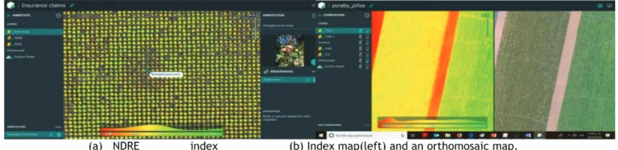
In precision agriculture, multispectral imaging has grown fundamentally in recent years. RedEdge camera from Micasense company can be used to capture large areas [26]. This Micasense camera (see Figure 3) provides the client with the software Pix4D [27] (see Figure 4) and it gives photogrammetric software tools for aligning and calibrating the multispectral images captured from RedEdge cameras.
(a) RedEdge-MX Camera
(b)Spectral resolution of the RedEdge-MX Multispectral Sensor.
Its main technical specifications [26] are: Weight: 231.9 g
Dimensions: 8.7cm x 5.9cm x 4.54cm
External Power: 4.2 V DC - 15.8 V DC (4 W nominal, 8 W peak) Wavelengths of available spectral Bands (nm):
• Blue (475 nm center, 20 nm bandwidth) • Green (560 nm center, 20 nm bandwidth) • Red (668 nm center, 10 nm bandwidth) • Red edge (717 nm center, 10 nm bandwidth) • Near-IR (840 nm center, 40 nm bandwidth)
RGB Color Output: Global shutter, aligned with all bands
Ground Sample Distance (GSD): 8 cm per pixel (per band) at 120 m AGL Capture Rate: 1 capture per second (all bands), 12-bit RAW
Interfaces: Serial, ethernet, removable Wi-Fi, external trigger, GPS, SDHC Field of View: 47.2° HFOV
(a) NDRE index (b) Index map(left) and an orthomosaic map. Figure 4: Example windows of Pix4D Drone maapping software.
Figure 3 and Figure 4 shows that MicaSense Camera and Pix4D software drone mapping tool. The RedEdge multispectral camera was intended to give crop producers to overview the crops through five different spectral bands: blue, green, red, red edge, and near infra-red [28]. These spectral bands are synthesized into false-color images that permit farmers to observe their crop harvest, fertilizer description and track variations over time.
4.5. Material sorting
The Austrian research institute CTR has developed a commercial product for material sorting based on spectral imaging [29]. The system is capable of recognising different
plastic materials on a conveyor belt travelling at speeds of up to 2 m/s and sorting the materials in different bins with the help of an array of pneumatic valves. The recognition is based on spectral reflectance measurements. The online detection rate at high speeds is based on high frame rates of up to 200 fps and real time calculations using field programmable gate array (FPGA) hardware.
Although the classification of different plastic materials is easier than classifying plant spectra, the example of material sorting could be adapted to classification of plants. Conveyor belt solution is obviously not possible on fields and cameras would need to be moved instead.
5. Conclusion
An overview of the current weed control methods and technologies involved in auto-matic weed detection has been given in this paper. Special attention has been drawn to the imaging systems and data processing methods to extract weed locations in fields. The limitations in previously built optical detection systems have been outlined and a set of requirement suggestions for future systems were given. Automatic mechanical weed control methods are limited to treating between-row weeds without accurate within-row crop and weed plant detection systems. In chemical control the lack of within-row plant detector results in unnecessarily high volumes of herbicides being sprayed in fields. Economical and environmental savings could be achieved if a reliable system locating the weed plants would be built.
Acknowledgments
This study is within the activities of project PrunusBot - Sistema robótico aéreo autónomo de pulverização controlada e previsão de produção frutícola (autonomous unmanned aerial robotic system for controlled spraying and prediction of fruit production), Opera-tion n.° PDR2020-101-031358 (líder), Consortium n.° 340, Initiative n.° 140 promoted by PDR2020 and co-financed by FEADER under the Portugal 2020 initiative.
References
[1] Soil Association (2005). Organic Market Report. Soil Association, Bristol, 2005. [2] Lobley, M., Reed, M., Butler, A., Courtney, P. and Warren, M. (2005). The Impact of
1-144.
[3] Baerdemaeker, J.D., Munack, A., Ramon, H. and Speckmann, H. (2001), “Mechatronic systems, communication, and control in precision agriculture.” IEEE Control Systems
Magazine 21(5), p. 48-70.
[4] Moran, M.S., Inoue, Y. and Barnes, E.M. (1997), ”Opportunities and Limitations for Image- Based Remote Sensing in Precision Crop Management.” Remote Sensing of
Environment 61(3), p. 319-440.
[5] Levitt, D.G., Simpson, J.R. and Huete, A.R. (1990), ”Estimates of surface soil water content using linear combinations of spectral wavebands.” Theoretical and Applied
Climatology 42(4), p. 245-252.
[6] Leon, C.T., Shaw, D.R., Cox, M.S., Abshire, M.J., Ward, B., Wardlaw III, M.C. and Watson, C. (2003), ”Utility of Remote Sensing in Predicting Crop and Soil Characteristics.” Precision Agriculture 4(4), p. 359-384.
[7] Thorp, K.R. and Tian, L.F. (2004), ”A Review on Remote Sensing of Weeds in Agriculture.” Precision Agriculture 5(5), p. 477-508.
[8] Godwin, R.J. and Miller, P.C.H. (2003), ”A Review of the Technologies for Mapping Within- field Variability ” Biosystems Engineering 84(4), p. 393-407.
[9] Pedersen, S.M., Fountas, S., Have, H. and Blackmore, B.S. (2006), ”Agricultural robots - system analysis and economic feasibility.” Precision Agriculture 7(4), p. 295-308. [10] Granitto, P.M., Verdes, P.F. and Ceccatto, H.A. (2005), ”Large-scale investigation
of weed seed identification by machine vision.” Computers and Electronics in
Agriculture 47(1), p. 15-24.
[11] NTech Industries, Incorporated (2003), Available at: http://www.ntechindustries. com/, Accessed: [17/1/2006].
[12] Antuniassi, U.R., Nery, M. da Silva, Carvalho, W.P.A., Ruiz, E.R.S. and León, M.J. De (2003), Performance Evaluation of an Optical Sensor for Weed Detection. ASAE Annual International Meeting, July 27-30, Las Vegas, Nevada, p. Paper number 031160.
[13] Slaughter, D. C., Giles, D.K. and Downey, D. (2008), “Autonomous robotic weed control systems: A review.” Computers and Electronics in Agriculture 61, p. 63–78. [14] Onyango, C., Marchant, J., Grundy, A., Phelps, K. and Reader, R. (2005), ”Image
Processing Performance Assessment Using Crop Weed Competition Models.”
Precision Agriculture 6(2), p. 183-192.
[15] Ashkenazi, V., Park, D. and Dumville, M. (2000), ”Robot positioning and the global navigation satellite system.” Industrial Robot 27(6), p. 419-426.
[16] Gerhards, R., Sökefeld, M., Timmermann, C., Kühbauch, W. and Williams, M.M. (2002), ”Site- Specific Weed Control in Maize, Sugar Beet, Winter Wheat, and Winter Barley.”
Precision Agriculture 3(1), p. 25-35.
[17] Have, H., Nielsen, J., Blackmore, S. and Theilby, F. (2005), “Autonomous Weeder for Christmas Trees - Basic Development and Tests.” Danish Environmental Protection Agency, Report number: Pesticides Research No. 97.
[18] Billingsley, J. and Schoenfisch, M. (1995), ”Vision-guidance of agricultural vehicles”
Autonomous Robots 2(1), p. 65-76.
[19] Marchant, J.A., Hague, T. and Tillett, N.D. (1997),”Row-following accuracy of an autonomous vision-guided agricultural vehicle.” Computers and Electronics in
Agriculture 16(2), p. 165-175.
[20] Åstrand, B. and Baerveldt, A.-J. (2005), ”A vision based row-following system for agricultural field machinery ” Mechatronics 15(2), p. 251-269.
[21] Tillett, N.D., Hague, T. and Miles, S.J. (2002), ”Inter-row vision guidance for mechanical weed control in sugar beet.” Computers and Electronics in Agriculture 33(3), p. 163-177.
[22] Søgaard, H.T. and Olsen, H.J. (2003), ”Determination of crop rows by image analysis without segmentation.” Computers and Electronics in Agriculture 38(2), p. 141-158. [23] Han, S., Zhang, Q., Ni, B. and Reid, J.F. (2004), ”A guidance directrix approach to
vision- based vehicle guidance systems.” Computers and Electronics in Agriculture 43(3), p. 179-195.
[24] Kise, M., Zhang, Q. and Más, F. Rovira (2005), ”A Stereovision-based Crop Row Detection Method for Tractor-automated Guidance.” Biosystems Engineering 90(4), p. 357-367.
[25] Hsu, S.M. and Burke, H.-h.K. (2003), ”Multispectral Fusion with Hyperspectral Imaging Data: Detection and Classification.” Lincoln Laboratory Journal 14(1), p. 145-159. [26] MicaSense (2019), ”User Manual Micasense Sensors” Revision 03, January 2019.
[27] Pix4D (2017), ” Pix4Dmapper 4.1 User manual” Pix4D mapper. Available
at:
https://support.pix4d.com/hc/en-us/articles/204272989-Offline-Getting-Started-and-Manual-pdf.
[28] Caratao, Z., Gabel, K., Arun, A., and Myers. B. (2018), ”Micasense Aerial Pointing and stabilization System: Dampening In-Flight Vibrations for Improved Agricultural Imaging.” 2018 AIAA Information Systems-AIAA Infotech @ Aerospace, AIAA 2018-1239.
[29] Kulcke, A. and Kerschhaggl, P. (2006), ”High Speed NIR Spectral Imaging in Recycling Applications.” 3rd International Spectral Imaging Workshop, ECCV 2006, 13/5, Graz, Austria,