1Instituto de Geociências e Ciências Exatas – IGCE, Universidade Estadual Paulista “Júlio de Mesquita Filho” – UNESP, Rio Claro (SP), Brazil. E-mail: [email protected], [email protected], [email protected] e [email protected]
2Instituto de Geociências, Universidade de São Paulo – USP, São Paulo (SP), Brazil.E-mail: [email protected]
*Corresponding author.
Manuscript ID: 20150014. Received: 07/02/2015. Approved: 08/21/2015. ABSTRACT: he Pantanal Basin is an active sedimentary basin in central-west Brazil that consists of a complex alluvial systems tract characterized by the interaction between diferent river systems de-veloped in one of the largest wetlands in the world. The Paraguay River is the trunk river system that drains the water and part of the sediment load received from areas outside of the basin. Depositio-nal styles vary considerably along the river proiles throughout the basin, with the development of entrenched meandering belts, anastomosing reaches, and loodplain ponds. Paleodrainage pat-terns are preserved on the surface of abandoned lobes of luvial fans, which also exhibit many degradational channels. Here, we propose a novel classiication scheme according to which the geo-morphology, hydrological regime and sedimentary dynamics of these fluvial systems are determined by the geology and geo-morphology of the source areas. In this way, the following sys-tems are recognized and described: (I) the Paraguay trunk-river plains; (II) fluvial fans sourced by the tablelands catchment area; (III) luvial fans sourced by lowlands; and (IV) luvial interfans. We highlight the importance of considering the inluences of source areas when interpreting contrasting styles of luvial architectures in the rock record.
KEYWORDS: Pantanal; wetlands; fluvial megafan; modern depositional environments; alluvial systems tract.
The Quaternary alluvial systems
tract of the Pantanal Basin, Brazil
Trato de sistemas aluviais do Quaternário da Bacia do Pantanal
Mario Luis Assine1*, Eder Renato Merino1, Fabiano do Nascimento Pupim2,
Hudson de Azevedo Macedo1, Mauricio Guerreiro Martinho dos Santos1
INVITED REVIEW
RESUMO: A Bacia do Pantanal é uma bacia sedimentar situada no Cen-tro-Oeste do Brasil, caracterizada pela presença de um moderno trato deposi-cional aluvial e pela interação de vários tipos de sistemas desenvolvidos em uma das maiores e mais importantes áreas úmidas do planeta. O Rio Paraguai rep-resenta o rio-tronco do sistema e drena a água e parte da carga sedimentar recebida de outras áreas extrabacinais. Os rios nos diferentes sistemas apre-sentam mudanças de estilo luvial em consequência de fatores alogênicos e autogênicos, com desenvolvimento de cinturões de meandros incisos, domínios distributários não coninados e mundanças de canal único para padrões multi-canal (anabranching). A superfície de lobos abandonados apresenta complexa rede de paleocanais e canais degradacionais tributários superimpostos. Com base na geomorfologia, na hidrossedimentologia e nos processos de sedimentação, é proposta classiicação dos sistemas aluviais do trato deposicional do Pantanal em quatro grupos principais: (I) planícies do rio tronco; (II) leques luviais com bacias de captação em planaltos sedimentares; (III) leques luviais formados por rios provenientes de terrenos pré-cambrianos arrasados; e (IV) planícies interle-ques. Os sistemas deposicionais que compõem o trato deposicional do Pantanal, cujos estilos são condicionados por fatores autogênicos (construção e abandono de lobos) e alogênicos (mudanças climáticas e condicionantes tectônicos), são importantes análogos modernos para a interpretação de unidades geológicas de origem aluvial de diferentes períodos do tempo geológico.
INTRODUCTION
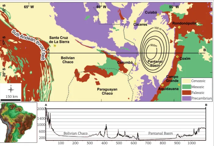
he Pantanal is an active sedimentary basin characte-rized by basin-margin faults and multiple subsurface faul-ted blocks, encompassing a series of depressions in which a more than 500 m-thick sedimentary succession has accu-mulated (Assine 2003, Assine & Soares 2004; Fig. 1). Active tectonics is conirmed by recent earthquakes, tectonically-controlled streams, and diferential subsidence within the basin (Assumpção et al. 2004; Assumpção & Sacek 2013). he modern depositional system forms the largest tropical wetland in the world (Por 1995), comprising an approxi-mately 150,000 km2 seasonally-looded area developed most
prominently in central-west Brazil (Assine 2015). he various morphologies of the modern depositional systems were pre-viously classiied according to landscape features, looding dynamics and hydroperiods, lowing rivers, vegetation type, and local names (e.g. Hamilton et al. 1996, Silva & Abdon 1998, Padovani 2010).
he sedimentary successions of the Pantanal Basin record the deposition on a large alluvial plain characterized by the interplay between luvial fans and megafans, as well as lu-vial interfans and a trunk lulu-vial plain. hese distinct allulu-vial systems are part of a huge depositional tract, which relects
the geomorphological heterogeneity of the basin. he term system tract is used to describe contemporaneous genetically three-dimensional depositional systems (Brown & Fisher 1977). Here, we propose a novel classiication of the allu-vial systems of the Pantanal Basin, and organize them into groups of luvial-system tracts characterized by contrasting catchment areas, namely the Palaeozoic Paraná Basin tab-lelands, the lowlands of nearby Precambrian metamorphic terrains, and the alluvial plain itself. Particular luvial styles, sediment load, discharge, and hydrologic regime typiies each system. Many of these rivers change in style downstream, passing from luvial fans to interfans or, in the case of the Paraguay River, to a trunk river system; aggradation and degradation dominate diferent parts of individual systems. We characterize the particular hydro-sedimen-tological functioning of each system and the associated mass transfer to the basin. his study aims at providing a robust classiication scheme to understand luvial sys-tems developed in an actively subsiding tropical basin. he Pantanal Basin is an ideal and exceptional analo-gue for the development of facies models regarding the interpretation of alluvial successions in the rock record. Implications include the development of a complex and broadly-applicable depositional model for continental
Figure 1. Geological setting of the Pantanal Basin (topographical proile based on South America SRTM-DEM; sediment thickness contours in meters).
2000
1400 1000
200 600
600 700 800 900 1000 100 200 300 400 500
Bolivian Chaco Pantanal Basin
Cenozoic Mesozic
A
Lineament River Borehole Drills (Total depth = meters)
reached the precambrian basement did not reach the precambrian basement
B
Figure 2. Distinct looding patterns during dry and wet seasons in the Pantanal wetland (the yellow line is the wetland border). (A) Wet season 2011, MODIS/Terra MOD13Q1 R(MIR)G(EVI)B(Blue) composite band; (B) Dry season of 2008, MODIS/Terra MOD13Q1 R(MIR)G(EVI)B(Blue) composite band. Dark colors in the images indicate looded areas, which are in many sites tectonically controlled. Geological lineaments indicate the general trends of brittle structures within the basin.
sedimentation in order to predict the overall architec-ture and facies assemblages of luvial deposits in the rock record from basin- to outcrop-scale.
he depositional tract of the Pantanal was mapped using several types of orbital data (e.g. Landsat series, GeoCover Circa 1990 and 2000, SPOT, ASTER and MODIS/Terra MOD13Q1; 90 m SRTM digital elevation model – DEM; aerial-photography; geological and geomorphological maps of the Geological Survey of Brazil). High- to medium-re-solution spatial, radiometric and multitemporal satellite images were utilized to assess morphological zones and features within the basin. In order to understand the sea-sonal lood dynamics of the Pantanal and its distinct mor-phological features under such contrasting water regimes, we used images from both dry and wet season of diferent years. Hydro-sedimentologic information was obtained from datasets of the Brazilian Water Agency (ANA) (http:// hidroweb.ana.gov.br).
he depositional systems of the Pantanal basin were dis-tinguished based on the following criteria:
■ delimitation of the Pantanal plain based on the propo-sal of Padovani (2010);
■ zonation of distinct depositional systems based on mor-phological similarity recognized on orbital data;
■ mapping of both recent and ancient minor-scale land-forms of depositional and erosive nature; and
■ identiication of paleochannels and other evidence of changes in the river pattern and location through time.
PHYSICAL SETTINGS
surround the basin on its north, south and west sides, whe-reas the tablelands of the Palaeozoic Paraná Basin crop out to the east (Fig. 1).
he eastern margin of the basin is characterized by con-vex-eastward planform geometry, but the western margin is characterized by a more irregular limit, with many pro-tuberances and segments that are apparently erosional, for-ming a complex arrangement of fractures of both NNW and WNW strikes. It is likely that many of these fractures were inherited from the underlying basement rocks. he nor-thern limits of the basin are characterized by multifaceted array of NE- and NW- trending fractures, clearly inherited from the basement rocks. he southern limit is marked by the NW-striking Bodoquena plateau, a horst that separa-tes the Pantanal Basin to the northeast and the Chaco Basin to the southwest.
Bedrock rivers draining Paleozoic sedimentary plateaus and dissected Precambrian basement feed the basin. hese rivers become unconined upon entering the basin, where they experience lower gradients and diminished water low of the wide alluvial plain (Assine & Silva 2009). he mor-phological characteristics and the high sediment supply determine the avulsive nature of the active channels and paleochannels, typically resulting in the development of various multichannel systems and distributary planforms further downstream (Assine 2005, Assine et al. 2014). he dominant depositional form is that of a radial, distribu-tive channel pattern (Nichols & Fisher 2007, Hartley et al. 2010), including megafans, luvial fans, and small debris-low-dominated alluvial fans associated with the basin boar-der escarpments. his depositional-setting type has been recently suggested as the dominating alluvial style in the alluvial rock record (Weissmann et al. 2010).
he Pantanal Basin preserves up to 500 m-thick depo-sits that record Quaternary climatic luctuations, including the Pleistocene highly seasonal rainfall and dry climate, and the Holocene wet and warm conditions (Ab’Sáber 1988, McGlue
et al. 2012). Many paleochannel planform observed through satellite imagery on the surface of inactive parts of the modern systems were originated from river-system deposition with styles that markedly contrast with the modern channel sys-tems (Assine & Soares 2004, Assine et al. 2014, Macedo
et al. 2014), providing a clear perspective to understand the climatic and tectonic impacts on luvial dynamics.
he basin formation has long been associated with the Andean tectonics (Almeida 1959), more speciically to a subsidence model due to extensional stress at the forebulge (Shiraiwa 1994, Ussami et al. 1999) or in the back-bulge domain (Horton & DeCelles 1997) of the Andes foreland system, which includes the Chaco Basin as the foredeep area. However, the mechanism of basin formation remains
unsolved, and new information must be considered, such as the negative velocity anomalies of seismic wave propagation at diferent lithosphere depths below the Pantanal region (Feng et al. 2007). Besides, the basin initiation during the Quaternary is uncertain and the lack of geochronological data leaves open the possibility that the basin formed much earlier, perhaps during an interval of widespread tectonism in southern Brazil during the Eocene-Miocene (Assine et al. 2015a). Nonetheless, the relict landscapes and the Quaternary surface deposits document the numerous climatic luctu-ations of the Cenozoic, providing valuable insights on the overall preserved architecture and facies assemblages that accumulated under such climatic conditions.
he Pantanal is one of the largest wetlands in the world (Por 1995, Fraser & Keddy 2005, Junk et al. 2006), and most of its landscapes are pristine and home to a rich biodiversity (Alho 2008, Assine 2015). Its savanna climate (Alho 2005) is characterized by mean temperature range between 20 and 27ºC, a negative water balance determined by a precipitation range between 800 and 1,300 mm, and evaporation range between 1,300 and 1,600 mm. he wetland environment is guaranteed by water inlow from the surrounding plate-aus, and facilitated by slow surface runof (promoted by low river-plain gradients), and iniltration and retention by the sandy alluvial plain (Assine et al. 2015b). he presence of standing water is critical for both patterns of biodiversity and biogeochemical cycling.
DEPOSITIONAL TRACT
decreasing of river-channel widths and discharge; other rivers form large-area permanently loodbasins and complexly-de-veloped lacustrine systems.
he Pantanal is an exorheic basin (i.e., externally drai-ned), with the Paraguay River carrying water and sediment to the Chaco Basin. However, most of the sediment loaded by rivers is deposited within the Pantanal wetland. Data from gauge stations of the main rivers (Paraguay, Cuiabá, São Lourenço, Piquiri, Taquari, Aquidauana, and Miranda) at their entrance into the Pantanal reveal that the suspen-ded sediment supply to the basin is ~25 million ton/year. Only 10% of this total is recorded in luvial stations loca-ted in the Paraguay River south of the Nabileque luvial fan (Porto Murtinho gauge station), which means that 90% of the sediment-load is retained in the Pantanal basin. he presence of many bars indicates very high bottom traction transport in most of the Pantanal rivers, but there is no information about the amount of bed-load sediment supply to the basin.
A classiication scheme describing the Pantanal basin, in which distinct systems are related to speciic source-area geomorphologies (Fig. 3), is here proposed. We identify four primary categories:
■ the Paraguay trunk-river plains;
■ luvial fans sourced by the tablelands catchment area;
■ luvial fans sourced by lowlands; and
■ luvial interfans.
Debris-low-related alluvial fans occur on the basin-bo-arder pediment slopes associated with the eastern tableland escarpments, characterized by coarse-grained sandstone and matrix-supported conglomerate; and calcretes and ferricretes duricrusts associated with some of these deposits (Boggiani & Coimbra 1995, Nascimento et al. 2015). Smaller-scale alluvial plains are mapped in the basin-border, but will not be discussed in this paper. Other features include complex loodplain-lake systems, which are characterized by various forms and scales, and contrasting chemical properties (McGlue
et al. 2011, McGlue et al. 2015). Such lakes are developed in areas of active loodplains, as well as in abandoned parts of megafans. Some were formed by water damming resul-ting from meander-belt aggradation and basin-boarder con-inement, whereas others present orientations which can be related to tectonic controls and other mechanisms not clearly understood yet, including long-term climatic luctuations (Bezerra & Mozeto 2008; McGlue et al. 2012).
Tableland-catchment fluvial fans
Tableland-catchment luvial fans are located in the eastern limits of the basin and are sourced by dissected sedimentary tablelands developed on Paleozoic-Mesozoic deposits of the Paraná sedimentary basin. Deep luvial
erosion in the catchment area is responsible for high sedi-ment yield carried to the Pantanal Basin. he sedisedi-ment yield of these luvial systems can reach 22.5 million ton/year, being responsible for ~90% of total suspended load sedi-ment supplied to the Pantanal Basin. he suspended sediment loaded by the Taquari River is nowadays the largest, reaching up to 72% of the total.
Crossing sharp escarpments and leaving the catchment area within the plateau, these rivers form large-scale luvial fans (megafans) by depositing their sediment loads as a result of much reduced topographic gradients within the Pantanal Basin. Famous examples of such fans are the Taquari and São Lourenço megafans (Figs. 3 and 4), large-scale systems characterized by modern distal depositional lobes and fee-der rivers entrenched in upper fan Pleistocene-aged allu-vial deposits. he Aquidauana, Taboco, Itiquira and Negro megafans belongs to this group, but are characterized by smaller areas (Fig. 3).
The Taquari River forms the largest megafan of the Pantanal Basin, with an area of ~50,000 km2, accounting
for about 37% of the Pantanal Basin area (Assine 2003, Zani
et al. 2012). he river is characterized in its alluvial reaches by an entrenched meander belt in the upper fan (Figs. 4A and 5A), but loss of coninement downstream of the inter-section point results in multiple, narrow and shallow dis-tributary channels, progressively decreasing in discharge and forming the modern lower-fan lobe (Assine 2005). his megafan is easily visible in satellite imagery and accu-mulates large volume of sediments, particularly on its loo-dbasin (approximately 16 million ton/year). Avulsion is the main process within this system that typically develops by progradation of splays into loodbasin accommodation, with many events recorded on large-scale geomorphic features, such as avulsion belts and diverted paleochannels (Assine 2005, Buehler et al. 2011). he southern part of the Taquari megafan is marked by more than 10,000 shallow lakes, in a region named Nhecolândia. hose circular to elliptical small lakes are elongated in a NE direction, and their margins are bordered by up to 5 m-height sand ridges. Most of them are seasonally looded, and present freshwater hydrochemistry and intense colonization by aquatic macrophytes. Some of these lakes (~10%) are isolated from pluvial surface low and are characterized by white-sand beaches and brackish to saline water, with large proliferation of cyanobacteria. hese lakes are alkaline salines and present pH values of up to 10, with the presence of bicarbonate, chlorinated and sodic waters (Barbiéro et al. 2002).
he São Lourenço megafan is the third largest megafan of the Pantanal, with an approximate area of 13,000 km2.
Figure 3. Depositional systems tract.
Fluvial Fans
(tablelands-catchment) 1 - São lourenço 2 - Itiquira 3 - Taquari 4 - Negro 5 - Taboco 6 - Aquidauana Fluvial Fans
(Lowlands-catchment) 7 - Jaurú
8 - Paraguay 9 - Cuiaba 10 - Miranda Fluvial Fans (Pantanal-catchment)
11 - Nabileque
Fluvial Interfans Plains 12 - Itiquira 13 - Negro 14 - Corixo Grande 15 - Negro (Bolivia
Paraguay River Plains 16 - Paraguay-Cáceres 17 - Paraguay-Canzin 18 - Paraguay-Amolar 19 - Paraguay-Corumbá 20 - Paraguay-Nabileque
50 km
22
0S
580W
20
0S
18
0S
16
0S
20
0S
18
0S
16
0S
580W 560W
Fluvial Fans (tablelands-catchment)
Fluvial Fans (Lowlands-catchment) Fluvial Fans (Pantanal-catchment) Aluvial Fans (piedmont) Nhecolândia lakes Platcaus and Lowlands Fluvial Gauge Station
Interfan Fluvial Plains
Paraguay Trunk River Plains
Undifferentiated Plains
Lacustrine Systems
Degradational abandoned lobes
Lake River Town
540W
numerous paleochannels, which exhibit various planform styles that typically diverge downstream into minor distri-butary channels; the styles evolved from the ancient mul-ti-thread braided channels to modern sinuous channels (Corradini & Assine 2012). Such channel-style evolution occurred as the result of climatic luctuations, from Late
A
15 km
450 m 200 m 175 m 150 m
Figure 4. Digital elevation model (90m SRTM-DEM) of the Upper Paraguay drainage basin showing the Pantanal wetland, the alluvial rivers and their sediment-source catchment areas. (A) The Taquari meander belt, conined within an incised valley in the upper megafan setting. (B) Distributary channels and paleochannels in the modern depositional lobe of the São Lourenço megafan.(C) Topographic contrast among rivers in megafan and interfan systems.
100 km
1000 m 200 m 130 m 70 m
Elevation
15 km
200m
130m 80m
B
150
140
130
120
110
100
Elevation (m)
0 50 100 150 200 250 300 350 400
Distance (km) N São Lourenço River Taquari River
Piqueri River
Negro River Aquidauana River
São Lourenço Megafan
Piquiri Interfan
Taquari
Megafan Negro
Interfan
Aquidauana Megafan
C
deposition) to ine-grained sand, siltstone and clay of the younger deposits. he distal reaches of the São Lourenço megafan are characterized by depositional lobes of distribu-tary channel-levee ridges, which resulted from progradation onto an unconined loodbasin (Assine et al. 2014; Fig. 4B). Approximately 1.3 million ton/year of suspended sediment is deposited on both distal (present lobe) and middle rea-ches of São Lourenço megafan.
he Aquidauana megafan is located in the SE region of the Pantanal Basin and presents a low direction to the NNW. It lows through an incised meander belt on its proximal
Figure 5. Meander Belts. (A) Taquari River; (B) Paraguay River; (C) Piquiri River; (D) Negro River. All images acquired from the online Basemap ArcGIS 10.2.2.
A B
C D
during the annual looding season, and no longer function as efective depositional luvial fans.
Lowland-catchment fluvial fans
Lowlands-catchment luvial fans are sourced by sediments from the surrounding Precambrian igneous and metamorphic rocks. he sediment yield of these systems is much smaller when compared with the tableland-catchment luvial fans, once they have less than 1.1 million ton/year of suspended load.
he Cuiabá luvial-fan system is the second largest mega-fan of the Pantanal Basin and the major megamega-fan of this category of system tract. It comprises a 15,000 km² area in the northern part of the Pantanal Basin, presenting an elon-gate and broad active depositional lobe characterized by a main channel, which presents numerous crevasse splays and a loodplain area characterized by many abandoned channels and ine sandy lobes. Its Pleistocene lobe is relatively small when compared with abandoned lobes of other systems, but it clearly shows ancient braided bifurcating channels. he active channel belt is characterized by low gradients (~ 0.20 m/km), and is entrenched in the proximal parts of
the fan. Drainage patterns considerably vary along the river path through the basin and are characterized by both mean-dering and anabranching channel planforms (Pupim 2014).
he Paraguay River lows in a meander belt entrenched in Pleistocene deposits in the northwest border of the Pantanal wetland (Fig. 5B). Downstream, the river forms a luvial megafan because of a loss of valley coninement and decreasing topogra-phic gradient when it enters the Pantanal Basin. Paleochannels are preserved on the surface of a Pleistocene-aged abandoned fan lobe, forming cross-paleodrainage networks. A main mean-dering channel, which is the Paraguay River proper, domina-tes the active depositional lobe, with bifurcations that forms anabranching channels, as well as hundreds of small lakes. he topographic gradient abruptly diminishes at the base of the modern depositional lobe and the Paraguay luvial plain style changes downstream from this point (Assine & Silva 2009).
of this system are located on the proximal portion of the fan, and this markedly contrasts with most of the other luvial systems of the basin. Along its lower course, the river lows in a meander belt incised over Pleistocene alluvial deposits, with many preser-ved oxbow lakes. he river is mostly degradational on its distal reaches, incising paleochannel belts with varied channel widths and morphologies. Pluvial sheet lows commonly erode the sur-rounding luvial plain, which are also drained by small ancient distributary channels during major loods (Merino et al. 2013).
Interfan riverplains
Interfan systems are luvial plains placed in between lu-vial fans (Sinha & Friend 1994). his kind of system presents increasing luvial discharge and sediment load downstream. he Corixo Grande river plain is located in the northwestern border of the Pantanal wetland, and collects water and sedi-ment derived from abandoned lobes of the Paraguay megafan, forming undiferentiated alluvial plains created by epheme-ral streams originated from the Bolivian territory. he Negro River plain (Bolivia/Paraguay) is another interfan system that contours the fringe from the Nabileque megafan and also drains waters from the Otuquis-Tucavaca and Pilcomayo megafans, which are situated to the west (Kuerten & Assine 2011). Sediment-source analyses indicate that the sediments of these systems are derived from reworking of previously deposited sediments on the alluvial tract, implying that these are plains-fed systems. he semi-arid climate westward to the Brazilian Pantanal determines the intermittency of such rivers. The Piquiri and the Negro interfan river plains sepa-rate the Taquari megafan from coalescent megafans at its north and south borders (Fig. 3). Both rivers are peren-nial and flow in meander belts confined within incised valleys (Fig. 5C and 5D). The meandering fluvial style is constant along the entire Piquiri course (Pupim et al. 2014), but the Negro River shows many changes in its fluvial style, crossing a permanently flooded basin downstream, where the river changes to a multichan-nel-planform pattern (Mendes 2014). Although both river interfan systems receive water and sediment mainly from within the alluvial domain, i.e. from the adjacent fluvial fans, they are also supplied from water and sedi-ments coming from piedmont alluvial fans, and directly from the tablelands-catchment areas. These interfan-ri-ver plains can be classified as mixed-fed systems, as the sediment supply originates from different source areas.
Paraguay trunk river plains
he Paraguay River lows from north to south and is the trunk luvial system of the Pantanal Basin. It is characterized by complex geomorphic features relecting the tectonic control on the western margin of the Pantanal basin, and interactions
with the distal portion of the other luvial megafans, deve-loping multiple styles from its entrance in the basin to its exit, where it joins the Chaco Basin further south. he river--mainstream plain comprises ive distinct luvial-loodplain compartments, each one presenting distinct depositional forms, channel pattern and hydrologic behavior (Fig. 6).
The Paraguay-Cáceres river-plain reach is located onto a north-northeast-oriented valley incised on Precambrian crystalline rocks; it exhibits a 4-5 km-wide aggradatio-nal meander belt, constrained by the Jaurú fluvial fan at the right and the NE- oriented ridges of Província Serrana Mountains at the left margin. The river gradient is relatively steep (6.30 cm/km), and the channel has irregular meanders with some small anabranching chan-nels, oxbow lakes and islands along this reach. When the Paraguay River enters into the Pantanal basin, the river gradient decreases (5.9 cm/km), and a channel bifur-cation forms the modern lobe of the Paraguay mega-fan. The 30 km-long Taiamã Island resulted from an important bifurcation (Bracinho River, to the left), and the downstream channel rejoining. Recently, crevasses upstream the Taiamã Island are diverting considerable volume of water flow into the floodplain on the right margin of the river, where the Canzi River develops an anabranching-channel system (Assine and Silva, 2009).
he Paraguay-Canzi river plain is characterized by low-gra-dient (2.6 cm/km) loodplain areas with many abandoned meander channels, large-scale seasonal loods, and numerous observed crevasse-splays. Hundreds of lakes form in the loo-dplain, including the largest, Lake Uberaba, as well as the large Gaíva Lake. his luvio-lacustrine plain is a large area of active sedimentation, receiving water and sediment from the Paraguay and Canzi rivers, the Cuiabá megafan, basin-margin drainages, and peripheral channels of the Corixo Grande interfan system.
2014). Inactive during the low-medium water level, these paleochannels receive water during the loods.
In the southernmost limit of the basin, the Paraguay River enters in the less subsiding area, where it crosses the Nabileque megafan in a narrow meander belt incised into Pleistocene-aged deposits (Kuerten & Assine 2011). Sponge spicules analysis in the Nabileque megafan indicate that this fan is a relict fea-ture that was constructed by the Paraguay River during the Pleistocene (Kuerten & Assine 2011, Kuerten et al. 2013). Most of the Nabileque megafan surface is subject to degradation, but abandoned lobes can be recognized by the existence of an intricate network of distributary paleochannels on its surface.
SYSTEMS TRACT
SEDIMENTARY DYNAMICS
he complex lood regime of the Pantanal Basin and the varied nature of the source rocks from which sediments are provided to the basin determine the heterogeneity of this lar-ge-scale alluvial plain, and the geology of source areas plays a fundamental role in the development of the luvial fans, particularly in terms of sediment supply, river gradients, and depositional dynamics. As demonstrated above, each group of system tracts is characterized by common geomorpholo-gical features which are partially derived from the processes
Figure 6. The Paraguay trunk river system is located on the western border of the Pantanal basin (A) Depositional systems that compose the Paraguay river plains (legend captions in the Fig. 3); (B) Landsat satellite image composition GeoCover Circa 2000.
50 Km
A
Cáceres
Paraguay -Cáceres
Uberaba Gaiva
Mandioré
Vermelha
Cácere
Corumbá Jacadigo
involved in the sediment and water transfer from the plateau to depositional lobes. he largest catchment areas are com-monly translated into larger modern luvial fan areas, with the Taquari as the most prominent example (Figs. 3 and 4).
Sediment is readily available in iner-grained particles for luvial transport in tableland-catchment luvial fans because the source rivers drain Paleozoic and Mesozoic recy-cled siliciclastic rocks of the Paraná Basin. hese rivers are deeply incised into their bedrocks in the catchment area, as opposed to rivers draining lowland areas, which results in higher luvial plain gradients. his situation results in ele-vated proportions of sediment load, and partly determines the nature and the governing dynamics of the related luvial fans, particularly the São Lourenço and Taquari megafans. hese fans notably constitute the most active depositional sites of the basin. Entrenched meander belts at their upper portions and overall sediment bypass presently characterize these megafans. Such belts are apparently related to a past regional incision event that proceeded major changes in depositional dynamics, which resulted in a transition from Pleistocene-aged braided luvial-channel planforms, observed in the inactive part of the megafans, to the observed mean-dering and anastomosing forms in the active depositional lobes (Assine 2005, Assine et al. 2014). his event resulted in intense pedogenesis, which is relected in aerially- and laterally-extensive horizons of preserved paleosols presen-ting both calcrete and ferricrete (Nascimento et al. 2015). he catchment area of the lowlands systems drain smaller and degraded areas of igneous and metamorphic source rocks from the Precambrian shield, providing relatively low amou-nts of sediment, and frequently resulting in sedimentary-load deicits, as observed in the Cuiabá Megafan (Pupim 2014). he interfan systems are also characterized by entrenched meander belts, which are similar in width and form to the meander belts developed in the upper portion of the above described megafans (Fig. 5). he regional base-level is determined by the Paraguay trunk river plains. Although abandoned parts of modern lobes do not receive water-low from rivers, they do receive from pluvial runof, especially during the wet sea-son, developing networks of tributary streams and reworking previously deposited sediments. hese sediments can be rede-posited on interfan plains and potentially further transported by the river and delivered to the trunk river system.
Fluvial-system processes act to compensate multiple envi-ronmental variables such as climate, basin settings, and the dynamics of depositional construction. he planform geome-tries that arise ultimately relect the interplay of these envi-ronmental gradients. Alluvial rivers constantly regulate their depositional equilibrium through changes in channel and slope geometries, developing multiple styles as a response to diferent sets of variables (Tooth 2000, Nanson & Huang
2008). hese variables are collectively classiied as autogenic, i.e. related to the depositional environment (e.g. low dyna-mics, sediment type), and allogenic, i.e. related to mechanisms which are external to the depositional dynamics (e.g. climatic luctuations, tectonic dynamics). However, in natural condi-tions, the clear distinction between auto- and allogeneic pro-cess is not a simple task, because detailed ield data are needed to quantify the relative importance of each process and due the complicated interactions among these controls exist (Miall 1996, Bridge 2003, Stouthamer & Berendsen 2007).
he auto- and allogenic process have diferent efects in the Pantanal system-tract sedimentary dynamic. he long-term cycles as the channel pattern changes, and deposition-erosion cycles can be attributed to allogenic factors of which climate appears to have driven the main changes during the late Quaternary. he short-term cycles as avulsions in distal luvial fans and meandering migration are mainly related to autogenic factors.
CONCLUSION
he Pantanal is an active sedimentary basin with faults and associated earthquakes relecting distinct basin blocks subsidence. Accommodation space generation results in discrete groups of fans, megafans, interfans and loodplain systems. The present work shows the first classification
according to hydro-sedimentological settings, a classiica-tion that allows a comprehensive distincclassiica-tion of the Pantanal alluvial systems, with each group being characterized by par-ticular geomorphologic features, hydrological regimes and sedimentological dynamics. he results presented herein highlight the role played by source areas and drainage sur-face low in inluencing sedimentation dynamics in luvial systems. hese roles originate a markedly complex hetero-geneity that can be easily depicted in the modern alluvial plain of the Pantanal Basin.
■ Tablelands-catchment luvial fans in the eastern limits of the basin sourced by dissected sedimentary tablelands related to the Paraná Basin deposits comprise major examples of megafans with higher sediment load. he Taquari and São Lourenço present key examples of active megafan on the basin. hese systems are characterized at
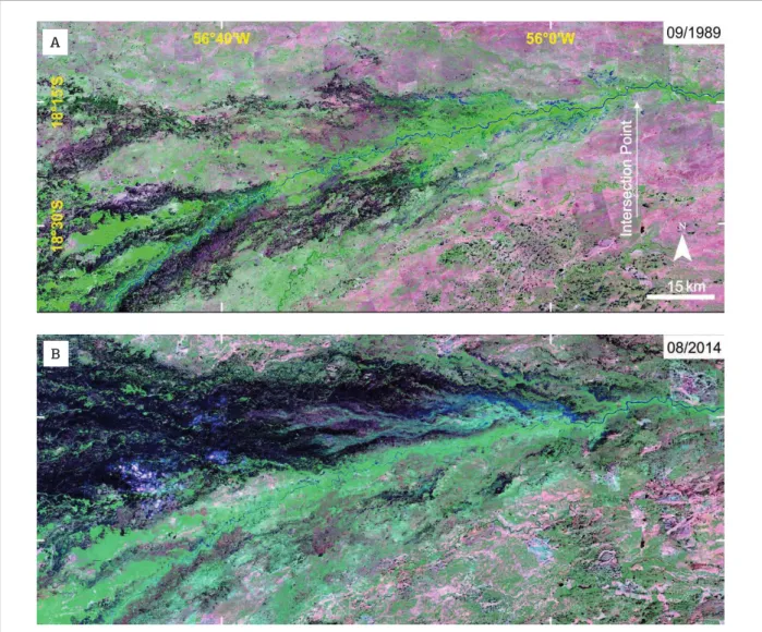
Figure 7. An important avulsion is in progress in the Taquari River at the Caronal farm. (A) There are no important crevasses in September 1989 (Landsat TM5 R7G4B3 composite band); (B) Downstream the intersection point, many crevasses and distributary channels are present on the right margin of the Taquari River in August 2014 (Landsat 8 OLI R7G5B3 composite band).
A
their entrance in the Pantanal by conined valleys, which are incised onto Pleistocene-aged deposits, and evolve at the distal portion by progradation of distributary lobes. Minor, and non active, systems are the Aquidauana, Negro, Taboco and Itiquira megafans.
■ Lowlands-catchment luvial fans sourced by sediments from the surrounding Precambrian igneous and meta-morphic rocks represent the second category of mega-fans, with the representative Cuiabá megafan as the second largest within the basin. he sediment load of these megafans is considerably smaller than the table-lands-sourced fans. Other examples of these systems are the Paraguay, Miranda and Jaurú megafans.
■ Interfan luvial systems represent smaller and conined loodplains developed at the fringe of major megafans systems, with diferent hydro-sedimentological settings characterized by downstream-increasing water discharge and sediment load, as a result of its coninement by the fringe of the megafans. he Itiquira and Negro interfan systems were mainly incised by perennial rivers, whereas the Corixo Grande and Negro (Bolivia) are intermittent and sourced mainly by distributary fan channels.
■ he Paraguay trunk-river plains is a complex geomor-phic system controlled by the Paraguay River develo-ping multiple styles from its entrance in the basin to its exit, where it joins the Chaco Basin further south. he river-mainstream plain comprises from north to south ive distinct luvial-loodplain compartments, each one presenting distinct depositional forms, channel pat-tern and hydrologic functioning. he Paraguay and the Nabileque megafans also play important roles on the loodplain afecting the water discharge and the sedi-ment yield, mainly during the annual loods.
■ Autogenic (e.g. flow dynamics, sediment type) and exogenous variables (e.g. climatic luctuations, tectonic
dynamics) control the evolution of the Pantanal Basin and its depositional systems. The variable nature of the rivers in the Pantanal basin provides evidence for paleohydrological changes that are controlled by avul-sion processes, luvial discharge luctuations and regio-nal base level variations that have been occurring since the Pleistocene.
he Pantanal Basin provides modern analogues for sedi-mentation dynamics in sedimentary basins dominated by depositional alluvial systems tract under semiarid to humid climates, and the preserved architecture and facies assembla-ges of these systems can provide various insights on the pre-diction of genetically-related deposits in the rock record. he varied depositional tracts determined by diferent source areas can develop strikingly contrasting lithological geometries and facies assemblages at the same stratigraphic level. his situa-tion can lead to inaccurate interpretasitua-tions if the inluence of source areas on the preserved architecture and sedimentary facies are unaccounted for when studying luvial successions in the rock record.
ACKNOWLEDGEMENTS
he authors thank the São Paulo Research Foundation (FAPESP 2014/06889-2; 2014/13937-3; 2014/23334-4) for inancial support to our research in the Pantanal Basin; the National Council of Technological and Scientiic Development (CNPq) for grants to MLA (308563/2013-1); Michael M. McGlue for critical evaluation and helpful suggestions to improve the text; Aguinaldo Silva for scientiic collabora-tion and logistical support in the ield; and the BJG editors Umberto G. Cordani and Claudio Riccomini for the invi-tation and encouragement to write this work.
Ab’Sáber A.N. 1988. O Pantanal Mato-Grossense e a teoria dos
refúgios. Revista Brasileira de Geograia, 50:9-57.
Alho C.J.R. 2005. The Pantanal. In: Fraser L.H. & Keddy P.A. (ed.)
The World’s Largest Wetlands - Ecology and Conservation. Cambridge University Press, 203-271.
Alho C.J.R. 2008. Biodiversity of the Pantanal: response to seasonal
looding regime and to environmental degradation. Brazilian Journal of Biology, 68:957-966.
Almeida F.F.M. 1959. Traços gerais da geomorfologia do Oeste brasileiro. In: Almeida FFM Lima M.A. (eds) Planalto Centro-Ocidental e Pantanal Matogrossense. Guia de Excursão nº 1 do
XVIII Congresso Internacional de Geograia. Conselho Nacional de Geograia, Rio de Janeiro, p 7-65
REFERENCES
Assine M.L. 2003. Sedimentação na Bacia do Pantanal
Mato-Grossense, Centro-Oeste do Brasil. Tese de Livre-Docência, Universidade Estadual Paulista – UNESP, Rio Claro, 106p.
Assine M.L. 2005. River avulsions on the Taquari megafan, Pantanal
wetland, Brazil. Geomorphology,70:357-371.
Assine M.L. 2015. Brazilian Pantanal: A Large Pristine Tropical Wetland. In: Vieira B.C., Salgado A.A.R., Santos L.J.C. (ed.)
Landscapes and Landforms of Brazil. Springer Netherlands, (World Geomorphological Landscapes), 135-146.
Assine M.L., Corradini F.A., Pupim F.N., McGlue M.M. 2014. Channel
arrangements and depositional styles in the São Lourenço luvial
megafan, Brazilian Pantanal wetland. Sedimentary Geology,
Assine M.L. & Silva A. 2009. Contrasting luvial styles of the
Paraguay River in the northwestern border of the Pantanal wetland,
Brazil. Geomorphology, 113:189-199.
Assine M.L. & Soares P.C. 2004. Quaternary of the Pantanal,
west-central Brazil. Quaternary International, 114:23-34.
Assine, M.; Merino, E.; Pupim, F.; Warren, L.; Guerreiro, R.; McGlue, M. 2015a. Geology and Geomorphology of the Pantanal Basin. In: I. Bergier and M. L. Assine (eds.), Dynamics of the Pantanal Wetland in South America. Springer Berlin, Heidelberg.
Assine, M.; Macedo, H.; Stevaux, J.; Bergier, I.; Padovani, C.; Silva, A. 2015b. Avulsive Rivers in the Hydrology of the Pantanal Wetland. In: I. Bergier and M. L. Assine (eds.), Dynamics of the Pantanal Wetland in South America. Springer Berlin, Heidelberg.
Assumpção M. & Sacek V. 2013. Intra-plate seismicity and lexural
stresses in central Brazil. Geophysical Research Letters, 40:487-491.
Assumpção M., Schimmel M., Escalante C., Barbosa J.R., Rocha M., Barros L.V. 2004. Intraplate seismicity in SE Brazil: stress
concentration in lithospheric thin spots. Geophysical Journal
International, 159:390-399.
Barbiéro L., Queiróz-Neto J.P., Ciornei G., Sakamoto A.Y., Cappelari B., Fernandes E., Valles V. 2002. Geochemistry of water and groundwater in the Nhecolândia, Pantanal of Mato Grosso, Brazil: variability and
associated process. Wetlands, 22:528-540.
Bezerra M.A.O. & Mozeto A.A. 2008. Deposição de carbono orgânico na planície de inundação do Rio Paraguai durante o Holoceno médio.
Oecologia Bras, 12:155-171.
Boggiani P.C. & Coimbra A.M. 1995. Quaternary limestones of the
Pantanal area, Brazil. Anais da Academia Brasileira de Ciências,
67:344-349.
Bridge J.S. 2003. Rivers and loodplains: forms, processes, and
sedimentary record.Oxford, Wiley-Blackwell, 491p.
Brown Jr. L.F. & Fisher W.L. 1977. Seismic-Stratigraphic Interpretation of Depositional Systems: Examples from
Brazilian Rit and Pull-Apart Basins. In: Payton C.E. (ed.) Seismic stratigraphy - applications to hydrocarbon exploration: AAPG Memoir 26, p. 213-248.
Buehler H.A., Weissmann, G. S.; Scuderi, L. A.; Hartley, A. J. 2011. Spatial and temporal evolution of an avulsion on the Taquari river
distributive luvial system from satellite image analysis. Journal of Sedimentary Research, 81:630-640.
Cordeiro B.M., Facincani E.M., Filho A.C.P., Bacani V.M., Assine M.L.
2010. Compartimentação geomorfológica do leque luvial do rio
Negro, borda sudeste da Bacia do Pantanal (MS). Revista Brasileira
de Geociências, 40:175-183.
Corradini F.A. & Assine M.L. 2012. Compartimentação
geomorfológica e processos deposicionais no megaleque luvial do
rio São Lourenço, Pantanal mato-grossense. Revista Brasileira de
Geociências, 42:20-33.
Facincani E.M. & Assine M.L. 2010. Geomorfologia luvial do rio
Aquidauana, borda sudeste do Pantanal Mato-Grossense. In: Martins
Junior C. & Oliveira Neto A.F. (ed.) Revelando Aquidauana. Campo
Grande, Editora da UFMS, (Serie Fronteiras nº 3), 267-284.
Feng M., van der Lee S., Assumpção M. 2007. Upper mantle structure of South America from joint inversion of waveforms and
fundamental mode group velocities of Rayleigh waves. J Geophys
Res, 112 (B4):B04312.
Fraser L.H. & Keddy P.A. 2005. The Word’s Largest Wetlands - Ecology
and Conservation. Cambridge University Press, 488 p.
Hamilton S.K., Sippel S.J., Melack J.M. 1996. Inundation patterns in the Pantanal wetland of South America determined from passive
microwave remote sensing. Archiv für Hydrobiologie, 137:1-23.
Hartley A.J., Weissmann G.S., Nichols G.J., Warwick G.L. 2010. Large Distributive Fluvial Systems: Characteristics, Distribution,
and Controls on Development. Journal of Sedimentary Research,
80:167-183.
Horton B.K., DeCelles P.G. 1997. The modern foreland basin system
adjacent to the Central Andes. Geology, 25:895-898.
Junk W.J., Brown M., Campbell I.C., Finlayson M., Gopal B., Ramberg L., Warner B.G. 2006. The comparative biodiversity of seven globally
important wetlands: a synthesis. Aquatic Sciences, 68:400-414.
Kuerten S. & Assine M.L. 2011. O rio Paraguai no megaleque do
Nabileque, sudoeste do Pantanal Mato-Grossense, MS. Revista
Brasileira de Geociências, 41: 642-653.
Kuerten S., Parolin M., Assine M.L., McGlue M.M. 2013. Sponge spicules indicate Holocene environmental changes on the Nabileque
River loodplain, southern Pantanal, Brazil. Journal of Paleolimnology,
49:171-183.
Macedo H.A., Assine M.L., Pupim F.N., Merino E.R., Stevaux J.C., Silva A. 2014. Mudanças paleo-hidrológicas na planície do rio Paraguai,
Quaternario do Pantanal. Revista Brasileira de Geomorfologia,
15:75-85.
McGlue M.M., Silva A., Corradini F.A., Zani H., Trees M.A., Ellis G.S., Parolin M., Swarzenski P.W., Cohen A.S., Assine M.L. 2011. Limnogeology in Brazil’s “forgotten wilderness”: A synthesis
from the large loodplain lakes of the Pantanal. Journal of Paleolimnology, 46:273-289.
McGlue M.M., Silva A., Zani H., Corradini F.A., Parolin M., Abel E.J., Cohen A.S., Assine M.L., Ellis G.S., Trees M.A., Kuerten S., Gradella
F.S., Rasbold G.G. 2012. Lacustrine records of Holocene lood
pulse dynamics in the Upper Paraguay River watershed (Pantanal
wetlands, Brazil). Quaternary Research, 78:285-294.
McGlue, M.; Silva, A.; Assine, M.; Stevaux, J.; Pupim, F. 2015. Paleolimnology in the Pantanal: Using Lake Sediments to Track Quaternary Environmental Change in the World’s Largest Tropical Wetland. In: I. Bergier and M. L. Assine (eds.), Dynamics of the Pantanal Wetland in South America. Springer Berlin, Heidelberg.
Mendes D. 2014.Geocronologia de formas deposicionais e evolução
da planície interleques do rio Negro, Quaternário da Bacia do Pantanal. Tese de Doutorado, Universidade Estadual Paulista - UNESP, Rio Claro, SP, 97p.
Merino E.R., Assine M.L., Pupim F.D.N. 2013. Estilos luviais e
evidências de mudanças ambientais na planície do rio Miranda,
Pantanal. Revista Brasileira de Geomorfologia, 14:127-134.
Miall A.D. 1996. The Geology of Fluvial Deposits. Berlin,
Springer-Verlag, 582p.
Nanson G.C. & Huang H.Q. 2008. Least action principle, equilibrium states, iterative adjustment and the stability of alluvial channels.
Earth Surface Processes and Landforms, 33:923-942.
Nascimento A.F.; Furquim S.A., Graham R.C., Beirigo R.M., Junior J.C.O., Couto E.G., Vidal-Torrado P. 2015. Pedogenesis in a
Pleistocene luvial system of the Northern Pantanal – Brazil. Geoderma, 255:58-72.
Nichols G.J. & Fisher J.A. 2007. Processes, facies and architecture of
luvial distributary system deposits. Sedimentary Geology, 195:75-90.
Padovani C.R. 2010. Dinâmica das Inundações do Pantanal. Tese
Por F.D. 1995. The Pantanal of Mato Grosso (Brazil) - World’s Largest Wetlands. Dordrecht, The Netherlands, Kluvwer Academic Publishers, 122p.
Pupim F.N., Assine M.L., Merino E.R., Macedo H.A., Silva A. 2014. A
planície interleques do rio Piquiri, bacia do Pantanal. In: 5º Simposio
de Geotecnologias no Pantanal, Campo Grande, MS, p.848-857.
Pupim F.N. 2014.Geomorfologia e paleo-hidrologia dos megaleques dos
rios Cuiabá e São Lourenço, Quaternário da Bacia do Pantanal. MS Tese de Doutorado, Universidade Estadual Paulista - UNESP, Rio Claro - SP, 109p.
Shiraiwa S. 1994. Flexura da litosfera continental sob os Andes
Centrais e a origem da Bacia do Pantanal.Tese de Doutoramento, Universidade de São Paulo, IAG, São Paulo.
Silva J.S.V. & Abdon M.M. 1998. Delimitação do Pantanal brasileiro e
suas sub-regiões. EMBRAPA, 33(Especial):1703-1711.
Sinha R. & Friend P.F. 1994. River systems and their sediment lux,
Indo-Gangetic plains, Northern Bihar, India. Sedimentology, 41:825-845.
Slingerland R. & Smith N.D. 2004. River avulsions and their
deposits. Annual Review of Earth and Planetary Sciences, 32:257–285.
Stouthamer E. & Berendsen H.J.A. 2007. Avulsion: The relative
roles of autogenic and allogenic processes. Sedimentary Geology,
198:309-325.
Tooth S. 2000. Process, form and change in dryland rivers: a review
of recent research. Earth-Science Reviews, 51:67-107.
Ussami N., Shiraiwa S., Dominguez J.M.L. 1999. Basement
reactivation in a sub-Andean foreland lexural bulge: The Pantanal
wetland, SW Brazil. Tectonics 18:25-39
Weissmann G.S., Hartley A.J., Nichols G.J.; Scuderi L.A., Olson M., Buehler H., Banteah R. 2010. Fluvial form in modern continental sedimentary basins: Distributive fluvial systems.
Geology, 38:39-42.
Zani H., Assine M.L., McGlue M.M. 2012. Remote sensing analysis of depositional landforms in alluvial settings: Method development and application to the Taquari megafan, Pantanal (Brazil).
Geomorphology, 161-162:82-92.