Development and Implementation of a New Land Value Capture Instrument Emília Malcata Rebelo
Universidade do Porto, Faculdade de Engenharia, Rua Dr. Roberto Frias, s/ n, 4200-465 PORTO, Portugal
CITTA – Research Centre for Territory, Transports and Environment e-mail: [email protected]
Phone number: +351225081482 Fax number: +351225081486 ABSTRACT
Historically the literature (Dick, 1998; Ingram and Hong, 2007; Smolka and Amborski, 2007; Rebelo, 2009, 2012)has asserted the idea of land social function, which means that the increase in land value that results from public decisions should be reassigned to the social welfare. But the territorial management instruments that render this concept operational (surplus value capture instruments) are still underdeveloped around the world (Hagman and Misczynski, 1978; McCluskey and Franzsen, 2005; Smolka and Amborski, 2007; Alexander et al., 2009; Alterman, 2010, 2011;).
The current article mainly focuses on the analysis and proposal of a new territorial management instrument aimed at capturing land surplus values that result from planning decisions and from the implementation of territorial plans. It is specifically based on the taxation of licensed built surfaces above the municipal abstract average built surface. It is duly explained, justified from an economic and financial perspective, and applied to the Detailed Plan of Avenida Papa João XXIII, in Fátima (in the Municipality of Ourém, Portugal). In this study average municipal building capacities are computed, as well as the concrete building capacities/m2 that accrue from urban interventions in the planning area for the different plots, anticipated kinds of uses, and applicable urban parameters. The homologous surplus values assigned by the Detailed Plan are further anticipated, as well as the potential values this new instrument would be able to collect. The research reported in this article is intended to contribute to the economic and financial sustainability of territorial planning and urban development, socially reassigning the surplus values engendered by public decisions, and strengthening municipal finance through the clarification of urban development-related funds´ origins and applications, and the development of understandable, quantifiable and user-friendly decision-support instruments.
It is a highly topical subject that fits into the objectives and priorities of Horizon 2020 (contribution of public policies to a smart, sustainable and inclusive growth), and of the new Portuguese Land, Territorial Ordinance and Urbanism Act and complementary legislation that regulates territorial planning, urban development and construction (currently under way).
From this research one can conclude that this new territorial management instrument is sustainable from an economic and financial standpoint. Its application is generalizable to other municipalities, and it potentially exerts important impacts in respective financial strengthening. It will further support the consolidation of the objectives of the new Portuguese Land, Territorial Ordinance and Urbanism Act, namely through the integration of territorial policies, a greater effectiveness in plan execution, a reinforced economic and financial sustainability of urban development processes, and the simplification of urban operations, promoting equity and social and territorial cohesion.
Keywords: Surplus values; Value-capture instruments; Urban development costs and benefits; Equal development distribution; Economic and financial sustainability
JEL Codes: C60; H21; H23; K11; O21
1. THEORETICAL FRAMEWORK
The concept of Land Value Capture (LVC) (Netzer, 1998; Ingram and Hong, 2007) argues that land value derived from public decisions should be recaptured, what enables a decrease in real prices and a more tight control over speculation (Rebelo, 2009, 2012), is economically efficient (Smolka and Amborski, 2007; Rebelo, 2009, 2012), and has allowed the implementation and improvement of land-based taxes (Walters, 2012), within the scope of urban public finance difficulties. The Lincoln Institute of Land Policy, the International Academic Association on Planning, Law and Property Rights, the Global Land Tool Network (GLTN) and the UN_Habitat have intensively worked on this issue.
Land value capture instruments(Smolka and Amborski, 2007) can be differentiated among (1) macro instruments (that consists either in land nationalization; substitution of private property by long-term public leaseholds; land banking; or land readjustment); (2) indirect instruments (aimed
at the capture of “unearned” increments(Alterman, 2011), what engenders incomes for specific public services), and (3) and direct instruments (which are policies that seek to capture all or some of the value rise in real property considering the explicit rationale that it is legal or morally desirable that landowners share with the overall community the wealth generated by public decisions (Alterman, 2010; Skabirskis and Qadeer, 1992).
The direct capture may refer to the surplus values that accrue from general economic or community conditions, or to those that result from public infrastructure works, or land use regulation (land use plans or development decisions).
Despite the strength of the rationale that the increase in land values that accrue from public decisions should be reassigned to the common welfare, most countries have avoided the adoption of direct surplus values capture. There are few comparative studies in the literature on this issue (Hagman and Misczynski, 1978; McCluskey and Franzsen, 2005; Alexander et al., 2009; Alterman, 2010). The latter – that compares thirteen countries with advanced economies - points out that only three of them have applied direct policies or instruments: the UK, Israel, and Poland.
Within the overall framework of land policies – that may express either through the straight control over urban development, through the fiscal control over urban development, or through the general influence over urban development (Correia, 1993) - the fiscal measures – that convey the influences over the general or specific urban development of places and uses through taxation devices – are the ones that straightly affect land market and uses, and may substantially influence the achievement of planning goals. Their efficiency may be assessed through the consequences they bring about to urban development planning and funding (DGOTDU, 2011). Land taxation aims at assuring a source of income to public administration (such as other taxes); redistributing wealth in order to fulfil the land social function, promoting equity and shrinking inequalities; giving back to society land surplus values accrued by planning decisions and public investments; and increasing the supply of urban development land (DGOTDU, 2011). But the efficiency of land taxation instruments must ground on objective assessment parameters that ensure a common reference framework that support equal treatment of owners, thus guiding surplus values that accrue from planning decisions or public investments on behalf of the general social interest.
In Portugal all the legislation concerning land, territorial ordering and urban development is currently under revision. The new Portuguese Land Territorial Ordinance and Urbanism Act was already approved (Proposta de Lei nº 183/XII, 2014), linked together with the revision of the juridical regime of Territorial Management Instruments, the juridical regime of Urbanization and Edification, and the new Cadastral Law. This is a deep amendment that intends to surmount some drawbacks and inconsistencies that accrued from the previous legislation, on the one hand, and to contribute to the structural reform of the state in these matters, on the other. In fact, the previously enforced legislation revealed hard to apply and often contradictory especially due to different complex plans that overlapped on the same territories (that harmed the clearness of applicable rules), the existence of multiple individual territorial plans and urban development models specific to each municipality (that hampered the sustainable planning organization and the integrated development), and from the planning model grounded on the spatial urban spreading (that couldn´t restrain the quick spread of vacant land).
Thus this revision involves the reassessment of the core paradigms that underlie land planning and management, territorial ordering, and urban development processes. One of the core innovative goals of this new paradigm sets that urban plans and programs should include an economic and financial sustainability model. This means that they should only be approved are they able to engender incomes equal or higher that the charges they will involve.
Within this scope, the current article proposes and reports in detail the technical study of a new fiscal instrument for land policy that fits the economic and financial model of urban plans and programs, settled in the new Land Territorial Ordinance and Urbanism Act. It is applied, as a case study, to the Detail Plan of Avenida Papa João XXIII, in Fátima (Aviso nº 15622/2009).
It proposes the recapture of the surplus values engendered by urban development decisions that involve concrete building capacities higher than the municipal abstract average building capacity (computed from the parameters settled in the Municipal Master Plan, Urban Development Plans, Detail Plans, parcelling out procedures, or other territorial management instruments).
The implementation of this new territorial management instrument is able to strengthen municipal finance, and to foster municipalities´ economic and financial sustainability, as it clears up the origins and applications of municipal funds from urban development processes, and it grants that surplus values accrued by most profitable urban operations are clearly reckoned and allocated on behalf of population´s general social interest. It will reduce land maximum values,
prevent speculation, and will not consubstantiate into a fiscal aggravation for most population, neither into an increase in building costs (Hong, 1998; Smolka and Amborski, 2003). Thus, the redistribution of urban development costs and benefits between the state and private stakeholders will become cleared up, and a fair justice will be assured within each municipality (Smolka and Amborski, 2003).
2. METHODOLOGY
This article reports the development and application of a 20% tax on the increase in land values (surplus values) that results from the license of a concrete building right higher than the average municipal building capacity. These surplus values is computed through the difference between the net land occupation index/m2 licensed in a certain urban development operation and the abstract average municipal building capacity, valued by the land prices/m2 computed according to land market trade. Whenever the licensed building capacity/m2 surpasses the average municipal building capacity/m2, a 20% tax will focus upon this difference. On the contrary if the building capacity/m2 is lower than the average building capacity/m2, the 20% tax will revert of behalf of the owner (Hagman and Misczynski, 1978).
The different stages that support its computation consist in the determination of (a) the abstract average municipal building capacity/m2, (b) the concrete building capacity/m2 assigned to specific urban interventions, (c) the land value, (d) the surplus value that accrue from the Detailed Plan, and (e) the potential collectable value that accrue from the application of this new territorial management instrument.
The abstract average municipal building capacity/m2 represents the gross built surface (expressed in m2) allowed by the enforced territorial planning instruments by m2 of land in a certain intervention area. It is computed through the quotient between the sum total of the surfaces where urban parameters of different planning tools apply, multiplied by respective occupation indexes (quotient between the implantation surface and the land surface, expressed in %) and the land use indexes (quotient between the total gross built surface and the land surface, expressed in m2 per land m2), weighted by the percentage assigned to each kind of use, and the total municipal buildable surface.
The concrete building capacity/m2 for a certain urban development operation results from the straight application of the urban parameters enforced by the applicable plans, weighted by the respective areas where these parameters apply.
The average municipal price/m2 based on market town property trade is determined through the quotient between the value of the annual average land property transactions and the land surface underlying the effective annual average gross built surface.
The surplus values considering the average municipal land price/m2 based on market town property trade is assessed through the product between the value of the difference in relation to the municipal average built surface/m2, the land price/m2 based on market trade, and the maximum licensed gross built surface, summed up to the whole plots of the urban intervention, for all the anticipated uses.
Finally, the potential collectable value that accrues from the application of this new territorial management instrument corresponds to a 20% tax on the previously computed value.
3. CASE STUDY: DETAIL PLAN OF AVENIDA PAPA JOÃO XXIII (FÁTIMA)
3.1. Brief characterization of the municipality of Ourém
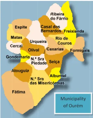
The municipality of Ourém locates in the Portuguese central region, in the district of Santarém. It is bound in the east by the municipalities of Ferreira do Zêzere and Tomar, in the southeast by Torres Novas, in the south by Alcanena, in the west by the municipalities of Leiria and Batalha, and in the north by Pombal and Alvaiázere. It spans a surface of about 417 km2, is made up by 18 parishes, and has a population density of 98,2 inhabitants/km2 (Figure 1).
3.1.1. Territorial planning instruments enforced in the municipality of Ourém The Municipal Master Plan of Ourém
development activities in this municipality, and that guides the applicable Urban Development Plans and Detail Plans (Article 6
Plans, Detail Plans and municipal regulations worked out according to the main guidelines of the Municipal Master Plan for the planning and management operational units, only the precepts of the latter are applicable, as well as the sta
(Article 7
1 The Municipal Master Plan of Ourém was approved by the Resolução do Conselho de Ministros n.º 148 This plan was ratified on the 12
n.º 18200/2009), being afterwards adjusted to the Regional Plan of Territorial Ordering of West and Tagus Valley PROTOVT (Aviso n.º 11779/2010, ratified by the Declaração de Retificação n.º 1614/
changed on the 29
plan for Pias Longas site (Aviso n.º 4800/2013), which involved a change in the National Environmental Reserve map of Ourém (Aviso n.º 4735/2013).
Figure 1. Map of the municipality of Ourém with respective parishes.
3.1.1. Territorial planning instruments enforced in the municipality of Ourém The Municipal Master Plan of Ourém
development activities in this municipality, and that guides the applicable Urban Development Plans and Detail Plans (Article 6
Plans, Detail Plans and municipal regulations worked out according to the main guidelines of the Municipal Master Plan for the planning and management operational units, only the precepts of the latter are applicable, as well as the sta
(Article 7th, Supplementary application).
The Municipal Master Plan of Ourém was approved by the Resolução do Conselho de Ministros n.º 148 This plan was ratified on the 12
n.º 18200/2009), being afterwards adjusted to the Regional Plan of Territorial Ordering of West and Tagus Valley PROTOVT (Aviso n.º 11779/2010, ratified by the Declaração de Retificação n.º 1614/
changed on the 29th March 2011 (Aviso n.º 7841/2011). On the 9
plan for Pias Longas site (Aviso n.º 4800/2013), which involved a change in the National Environmental Reserve Ourém (Aviso n.º 4735/2013).
Figure 1. Map of the municipality of Ourém with respective parishes. (Source: https://www.google.pt/)
3.1.1. Territorial planning instruments enforced in the municipality of Ourém The Municipal Master Plan of Ourém
development activities in this municipality, and that guides the applicable Urban Development Plans and Detail Plans (Article 6
Plans, Detail Plans and municipal regulations worked out according to the main guidelines of the Municipal Master Plan for the planning and management operational units, only the precepts of the latter are applicable, as well as the sta
, Supplementary application).
The Municipal Master Plan of Ourém was approved by the Resolução do Conselho de Ministros n.º 148 This plan was ratified on the 12th March of 2009 (Aviso n.º
n.º 18200/2009), being afterwards adjusted to the Regional Plan of Territorial Ordering of West and Tagus Valley PROTOVT (Aviso n.º 11779/2010, ratified by the Declaração de Retificação n.º 1614/
March 2011 (Aviso n.º 7841/2011). On the 9
plan for Pias Longas site (Aviso n.º 4800/2013), which involved a change in the National Environmental Reserve Ourém (Aviso n.º 4735/2013).
Figure 1. Map of the municipality of Ourém with respective parishes. (Source: https://www.google.pt/)
3.1.1. Territorial planning instruments enforced in the municipality of Ourém
The Municipal Master Plan of Ourém1 is the legal planning instrument that frames the urban development activities in this municipality, and that guides the applicable Urban Development Plans and Detail Plans (Article 6th, Urban hierarchy). In the absence o
Plans, Detail Plans and municipal regulations worked out according to the main guidelines of the Municipal Master Plan for the planning and management operational units, only the precepts of the latter are applicable, as well as the sta
, Supplementary application).
The Municipal Master Plan of Ourém was approved by the Resolução do Conselho de Ministros n.º 148 March of 2009 (Aviso n.º
n.º 18200/2009), being afterwards adjusted to the Regional Plan of Territorial Ordering of West and Tagus Valley PROTOVT (Aviso n.º 11779/2010, ratified by the Declaração de Retificação n.º 1614/
March 2011 (Aviso n.º 7841/2011). On the 9
plan for Pias Longas site (Aviso n.º 4800/2013), which involved a change in the National Environmental Reserve
Figure 1. Map of the municipality of Ourém with respective parishes. (Source: https://www.google.pt/)
3.1.1. Territorial planning instruments enforced in the municipality of Ourém
is the legal planning instrument that frames the urban development activities in this municipality, and that guides the applicable Urban Development
, Urban hierarchy). In the absence o
Plans, Detail Plans and municipal regulations worked out according to the main guidelines of the Municipal Master Plan for the planning and management operational units, only the precepts of the latter are applicable, as well as the statements settled in additional municipal regulations
The Municipal Master Plan of Ourém was approved by the Resolução do Conselho de Ministros n.º 148 March of 2009 (Aviso n.º 5416/2009), and later on, in the 15
n.º 18200/2009), being afterwards adjusted to the Regional Plan of Territorial Ordering of West and Tagus Valley PROTOVT (Aviso n.º 11779/2010, ratified by the Declaração de Retificação n.º 1614/
March 2011 (Aviso n.º 7841/2011). On the 9th
plan for Pias Longas site (Aviso n.º 4800/2013), which involved a change in the National Environmental Reserve
Figure 1. Map of the municipality of Ourém with respective parishes. (Source: https://www.google.pt/)
3.1.1. Territorial planning instruments enforced in the municipality of Ourém
is the legal planning instrument that frames the urban development activities in this municipality, and that guides the applicable Urban Development
, Urban hierarchy). In the absence o
Plans, Detail Plans and municipal regulations worked out according to the main guidelines of the Municipal Master Plan for the planning and management operational units, only the precepts of tements settled in additional municipal regulations
The Municipal Master Plan of Ourém was approved by the Resolução do Conselho de Ministros n.º 148 5416/2009), and later on, in the 15
n.º 18200/2009), being afterwards adjusted to the Regional Plan of Territorial Ordering of West and Tagus Valley PROTOVT (Aviso n.º 11779/2010, ratified by the Declaração de Retificação n.º 1614/
th April 2013 a modification was enforced in the plan for Pias Longas site (Aviso n.º 4800/2013), which involved a change in the National Environmental Reserve
Figure 1. Map of the municipality of Ourém with respective parishes.
3.1.1. Territorial planning instruments enforced in the municipality of Ourém
is the legal planning instrument that frames the urban development activities in this municipality, and that guides the applicable Urban Development , Urban hierarchy). In the absence of Urban Development Plans, Detail Plans and municipal regulations worked out according to the main guidelines of the Municipal Master Plan for the planning and management operational units, only the precepts of tements settled in additional municipal regulations
The Municipal Master Plan of Ourém was approved by the Resolução do Conselho de Ministros n.º 148
5416/2009), and later on, in the 15th October 2009 (Aviso n.º 18200/2009), being afterwards adjusted to the Regional Plan of Territorial Ordering of West and Tagus Valley PROTOVT (Aviso n.º 11779/2010, ratified by the Declaração de Retificação n.º 1614/2010, of 12
April 2013 a modification was enforced in the plan for Pias Longas site (Aviso n.º 4800/2013), which involved a change in the National Environmental Reserve
Figure 1. Map of the municipality of Ourém with respective parishes.
is the legal planning instrument that frames the urban development activities in this municipality, and that guides the applicable Urban Development f Urban Development Plans, Detail Plans and municipal regulations worked out according to the main guidelines of the Municipal Master Plan for the planning and management operational units, only the precepts of tements settled in additional municipal regulations
The Municipal Master Plan of Ourém was approved by the Resolução do Conselho de Ministros n.º 148-A/2002. October 2009 (Aviso n.º 18200/2009), being afterwards adjusted to the Regional Plan of Territorial Ordering of West and Tagus Valley
2010, of 12th August), and April 2013 a modification was enforced in the plan for Pias Longas site (Aviso n.º 4800/2013), which involved a change in the National Environmental Reserve
is the legal planning instrument that frames the urban development activities in this municipality, and that guides the applicable Urban Development f Urban Development Plans, Detail Plans and municipal regulations worked out according to the main guidelines of the Municipal Master Plan for the planning and management operational units, only the precepts of tements settled in additional municipal regulations
A/2002. October 2009 (Aviso n.º 18200/2009), being afterwards adjusted to the Regional Plan of Territorial Ordering of West and Tagus Valley – August), and April 2013 a modification was enforced in the plan for Pias Longas site (Aviso n.º 4800/2013), which involved a change in the National Environmental Reserve
According to Article 8th (Enforced planning instruments) of this same plan, inside the urban perimeter of Fátima applies the respective Urban Development Plan2; and in some areas inside the urban perimeter of Ourém apply the enforced Detail Plans.
After the passing of the Urban Development Plan of Fátima, two Detail Plans were enforced inside its urban perimeter, becoming applicable their urban parameters instead of those from the Urban Development Plan:
• Detail Plan of Avenida Papa João XXIII (Aviso nº 15622/2009);
• Detail Plan for the block formed by Rua Francisco Marto, Estrada da Lomba de Égua and Rua do Mercado (Portaria nº 67/99).
The Detail Plans enforced inside the urban perimeter of Ourém are:
• Detail Plan of the industrial area of Casal dos Frades (Despacho nº 195/91); • Detail Plan of the Health Centre of Ourém (Portaria nº 190/97);
• Detail Plan of Caridade (Portaria nº 496/93; Portaria nº 445/97; Declaração nº 376/99) • Detail Plan of Quinta do Ribeirinho (Resolução do Conselho de Ministros nº 159/2000) 3.1.2. Regulation of land use in the municipality of Ourém
In the regulation of the Municipal Master Plan of Ourém - Chapter III, concerning land uses, Article 33rd (Classes of spaces) - spaces are classified according to their land occupation, use and land use changes, within the following classes3: urban spaces; developable urban spaces; tourism; industry; extractive industry; equipment; agricultural; forest; agricultural-forest mixed uses; natural; canal-spaces and infrastructures.
In the same article (point 3.) urban perimeters are pointed out as including urban spaces, developable urban spaces, and industrial spaces, according to the delimitating borders settled in the ordering plan.
Article 35th (Urban hierarchy network) settles tree levels for built-up urban areas belonging to the municipality of Ourém, according to the functions anticipated for each one (they may eventually include sets of close built-up urban areas) (Table 1):
2 Portaria nº 633/95, of 21st June, which revision was approved by the Resolução do Conselho de Ministros n.º 148-B/2002 of 30/12. This plan underwent, after its approval, a simplified change on 30/01/2009 (Aviso n.º 2766/2009), and a later ratification on the 15th October of the same year (Aviso n.º 18200/2009).
• Level 1 encompasses built-up urban areas with trade, services and equipment functions at municipality and above municipality grounds;
• Level 2 includes built-up urban areas or sets of areas with trade, services and equipment functions at local grounds;
• Level 3 comprises the remaining built-up areas or sets of areas.
Table 1. Classification of built-up urban areas belonging to the municipality of Ourém according to the urban network hierarchy settled in respective Municipal Master Plan.
Level Parishes Built-up urban areas
1 Fátima Town of Fátima, Cova da Iria, Moita Redonda, Lomba d´Égua,
Aljustrel, Moimento, Casa Velha and Eira da Pedra 1
Nossa Senhora das
Misericórdias/Nossa Senhora da Piedade
Town of Ourém, Ourém/Castelo, Santo Amaro, Lagoa da Carapita, Vale do Lobo, Hortas, Regato, Corredoura, Lagarinho and Penigardos
2 Alburitel Alburitel
2 Atouguia Atouguia, Mourã, Murtal, Outeiro do Murtal, Pinheiro do Murtal, Feteira and Fontaínhas 2 Casal dos Bernardos Casal dos Bernardos and Casal dos Moleiros
2 Caxarias/Urqueira Caxarias, Vendas, Caxarias/Carvoeira, Pontes, Pisões, Cavadinha and Mata
2 Cercal Cercal, Vale do Feto and Ninho de Águia
2 Espite Espite, Cimo da Igreja, Braga, Casal Monte; Meliceira and Vale do
Ugreiro
2 Formigais Formigais, Casal da Igreja and Porto Velho
2 Freixianda Freixianda, Abades, Várzea do Bispo, Casal do Pinheiro, Aldeia de Santa Teresa, Porto do Carro and Vale do Carro
2 Gondemaria Gondemaria, Cidral, Fartaria, Palheiro and Cardiais
2 Matas Matas, Achada, Casal Menino, Cubal and Barreirinhas
2 Matas Lavradio, Vesparia and Perdigão
2 Nossa Senhora das
Misericórdias Vilar dos Prazeres
2 Nossa Senhora das Misericórdias Melroeira and Pinhel
2 Nossa Senhora da Piedade Vale Travesso, Casal Matos and Casal Castanheiro 2 Nossa Senhora da Piedade Alqueidão, Cartacha, Quinta Nova and Casais da Caridade 2 Nossa Senhora da Piedade Pinheiro, Pimenteira and Cabiçalva
2 Olival Olival and Aldeia Nova
2 Ribeira do Fárrio Fárrio and Reca
2 Rio de Couros Rio de Couros
2 Rio de Couros Sandoeira and Castelejo
2 Seiça Seiça, Pombalinho, Outeiro, Alqueidão, Carvalhal, Chão de Maçãs and Estremadouro
2 Seiça Peras Ruivas and Pedreiras
2 Urqueira Urqueira
Section I of chapter III of the Municipal Master Plan of Ourém lays down the rules for the use of urban spaces. Article 36th (Scope and main goal) features the urban spaces (demarcated in the ordering plan) as made up by the existing built urban knitwear provided with urban infrastructure, equipment and services. These spaces are predominantly aimed at housing, despite including other uses, such as tertiary activities, industry, agriculture or tourism, provided they hold housing-compatible characteristics.
Consolidated urban spaces (point 4. of the same article) rank, by their turn, into level 1, 2, or 3 subcategories of urban spaces.
As aforementioned, the urban perimeters of Ourém and Fátima correspond to level 1 built-up urban areas (article 39th, urban built-up areas of Ourém and Fátima). This article further states that rules laid down in articles 40th and 41st should be applied in Ourém and/or Fátima in the absence of Urban Development Plans or Detail Plans inside respective urban perimeters, considering:
• As medium-density urban spaces the wholly infrastructured urban areas where streets make up a close knitwear together with bordering parcels and plots, that are already built-up in over 50% of parcels and plots, with four or five-storey buildings;
• As low-density urban spaces the remaining developable urban areas, as well as the wholly or partly infrastructured urban areas.
The rules laid down in article 40th (Medium-density urban spaces in Ourém and Fátima) apply to buildings´ construction and enlargement in wholly infrastructured parcels or plots in medium-density urban spaces, in the absence of Urban Development or Detail Plans.
Article 41st (Low-density and very low-density urban spaces) settles that level 2 built-up urban areas correspond to low-density urban spaces, and level 3 built-up urban areas correspond to very low-density urban spaces. However, medium-density areas may be settled through Urban Development or Detail Plans in level 2 built-up urban areas with delimited planning and management operational units (point 2. of this article).
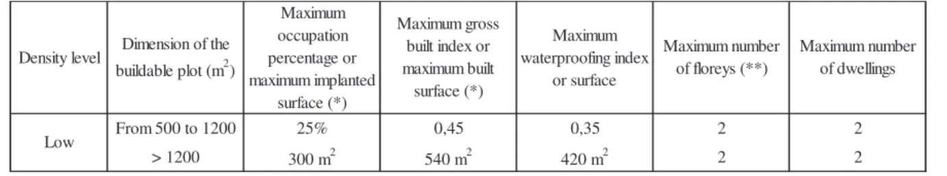
Article 42nd (urban-use parameters for low and very low-density urban spaces) specifies the following parameters for low and very-low density spaces, respectively:
Table 2. Urban parameters for low-density spaces in the municipality of Ourém settled in respective Municipal Master Plan.
Table 3. Urban parameters for very low-density spaces in the municipality of Ourém settled in respective Municipal Master Plan.
The urban parameters that industry-solely plots (compatible with other urban uses) must conform to are:
Table 4. Urban parameters for industry-solely spaces in the municipality of Ourém settled in respective Municipal Master Plan.
The section II of the Municipal Master Plan of Ourém focuses on developable urban spaces. Article 43rd (Scope and main goal) features urban developable spaces as aimed at urban
Density level Dimension of the buildable plot (m2) Maximum occupation percentage or maximum implanted surface (*) Maximum gross built index or maximum built surface (*) Maximum waterproofing index or surface Maximum number of floreys (**) Maximum number of dwellings From 500 to 1200 25% 0,45 0,35 2 2 > 1200 300 m2 540 m2 420 m2 2 2
(*) Including all the built surfaces
(**) Use of attics is admitted
Low
Density level Dimension of the buildable plot (m2) Maximum occupation percentage or maximum implanted surface (*) Maximum gross built index or maximum built surface (*) Maximum waterproofing index or surface Maximum number of floreys (**) Maximum number of dwellings From 500 to 1500 20% 0,36 0,3 2 2 > 1500 300 m2 540 m2 450 m2 2 2
(*) Including all the built surfaces
(**) Use of attics is admitted
Very low Dimension of the buildable plot (m2) Maximum occupation percentage or maximum implanted surface (*) Maximum gross built index or maximum built surface (*) Maximum waterproofing index or surface Maximum number of floreys (**) From 500 to 2000 35% 0,4 0,45 2 > 2000 700 m2 800 m2 900 m2 2
(*) Including all the built surfaces (**) Buildings´ maximum heigh is 7,5 m
spreading, namely housing and respective complementary functions, and also at industrial uses compatible with other urban uses.
Point 2. of this article stresses that the conditions
developable spaces intend to master the urban growth and consolidate the existing urban spaces, creating urban areas provided with the required infrastructures and collective equipment, making profits on investmen
spaces may result in medium
they fit (delimitated in the ordering plan). 3.1.3. Brief characterization of the De
The main goal of the Detail Plan of Avenida Papa João XXIII consists in setting up urban development and design regulations for land infrastructure, occupation and use, and respective linkages with the already existing
José Lamas e Associados, 2009).
proposed pieces. Figures 2 and 3, as follows, present the implantation plan, as well as respective subdivision into urban development units, and Table 5 features the land occupation proposal (Aviso nº 15622/2009):
spreading, namely housing and respective complementary functions, and also at industrial uses compatible with other urban uses.
Point 2. of this article stresses that the conditions
developable spaces intend to master the urban growth and consolidate the existing urban spaces, creating urban areas provided with the required infrastructures and collective equipment, making profits on investmen
spaces may result in medium
they fit (delimitated in the ordering plan). 3.1.3. Brief characterization of the De
The main goal of the Detail Plan of Avenida Papa João XXIII consists in setting up urban development and design regulations for land infrastructure, occupation and use, and respective linkages with the already existing
José Lamas e Associados, 2009).
proposed pieces. Figures 2 and 3, as follows, present the implantation plan, as well as respective ubdivision into urban development units, and Table 5 features the land occupation proposal (Aviso nº 15622/2009):
spreading, namely housing and respective complementary functions, and also at industrial uses compatible with other urban uses.
Point 2. of this article stresses that the conditions
developable spaces intend to master the urban growth and consolidate the existing urban spaces, creating urban areas provided with the required infrastructures and collective equipment, making profits on investments in built or to be built infrastructures and amenities. Urban developable spaces may result in medium-low, low or very low density spaces, according to the urban spaces they fit (delimitated in the ordering plan).
3.1.3. Brief characterization of the De
The main goal of the Detail Plan of Avenida Papa João XXIII consists in setting up urban development and design regulations for land infrastructure, occupation and use, and respective linkages with the already existing
José Lamas e Associados, 2009).
proposed pieces. Figures 2 and 3, as follows, present the implantation plan, as well as respective ubdivision into urban development units, and Table 5 features the land occupation proposal (Aviso nº 15622/2009):
spreading, namely housing and respective complementary functions, and also at industrial uses compatible with other urban uses.
Point 2. of this article stresses that the conditions
developable spaces intend to master the urban growth and consolidate the existing urban spaces, creating urban areas provided with the required infrastructures and collective equipment, making ts in built or to be built infrastructures and amenities. Urban developable low, low or very low density spaces, according to the urban spaces they fit (delimitated in the ordering plan).
3.1.3. Brief characterization of the Detail Plan of Avenida Papa João XXIII
The main goal of the Detail Plan of Avenida Papa João XXIII consists in setting up urban development and design regulations for land infrastructure, occupation and use, and respective linkages with the already existing and the proposed surrounding public space (Terraforma and José Lamas e Associados, 2009). It is made up by a set of written and drawn characterization and proposed pieces. Figures 2 and 3, as follows, present the implantation plan, as well as respective ubdivision into urban development units, and Table 5 features the land occupation proposal spreading, namely housing and respective complementary functions, and also at industrial uses Point 2. of this article stresses that the conditions stated by the current regulation to urban developable spaces intend to master the urban growth and consolidate the existing urban spaces, creating urban areas provided with the required infrastructures and collective equipment, making ts in built or to be built infrastructures and amenities. Urban developable low, low or very low density spaces, according to the urban spaces
tail Plan of Avenida Papa João XXIII
The main goal of the Detail Plan of Avenida Papa João XXIII consists in setting up urban development and design regulations for land infrastructure, occupation and use, and respective and the proposed surrounding public space (Terraforma and is made up by a set of written and drawn characterization and proposed pieces. Figures 2 and 3, as follows, present the implantation plan, as well as respective ubdivision into urban development units, and Table 5 features the land occupation proposal spreading, namely housing and respective complementary functions, and also at industrial uses stated by the current regulation to urban developable spaces intend to master the urban growth and consolidate the existing urban spaces, creating urban areas provided with the required infrastructures and collective equipment, making ts in built or to be built infrastructures and amenities. Urban developable low, low or very low density spaces, according to the urban spaces
The main goal of the Detail Plan of Avenida Papa João XXIII consists in setting up urban development and design regulations for land infrastructure, occupation and use, and respective and the proposed surrounding public space (Terraforma and is made up by a set of written and drawn characterization and proposed pieces. Figures 2 and 3, as follows, present the implantation plan, as well as respective ubdivision into urban development units, and Table 5 features the land occupation proposal spreading, namely housing and respective complementary functions, and also at industrial uses stated by the current regulation to urban developable spaces intend to master the urban growth and consolidate the existing urban spaces, creating urban areas provided with the required infrastructures and collective equipment, making ts in built or to be built infrastructures and amenities. Urban developable low, low or very low density spaces, according to the urban spaces
The main goal of the Detail Plan of Avenida Papa João XXIII consists in setting up urban development and design regulations for land infrastructure, occupation and use, and respective and the proposed surrounding public space (Terraforma and is made up by a set of written and drawn characterization and proposed pieces. Figures 2 and 3, as follows, present the implantation plan, as well as respective ubdivision into urban development units, and Table 5 features the land occupation proposal
Figure 2. Implantation Plan settled in the Detail Plan of Avenida Papa João XXIII (Source:
Figure 3. Urban development units previewed in the Detail Plan of Avenida Papa João XXIII
Table 5: Proposa
Avenida Papa João XXIII (Source:
Figure 2. Implantation Plan settled in the Detail Plan of Avenida Papa João XXIII (Source:
Figure 3. Urban development units previewed in the Detail Plan of Avenida Papa João XXIII
Table 5: Proposal concernin
Avenida Papa João XXIII (Source:
Figure 2. Implantation Plan settled in the Detail Plan of Avenida Papa João XXIII (Source:
Figure 3. Urban development units previewed in the Detail Plan of Avenida Papa João XXIII
l concerning the occupation of the urban development Avenida Papa João XXIII (Source:
Figure 2. Implantation Plan settled in the Detail Plan of Avenida Papa João XXIII (Source: http://www.dgotdu.pt/
Figure 3. Urban development units previewed in the Detail Plan of Avenida Papa João XXIII (Source: http://www.dgotdu.pt/
g the occupation of the urban development Avenida Papa João XXIII (Source: Terraforma
Figure 2. Implantation Plan settled in the Detail Plan of Avenida Papa João XXIII (Source: http://www.dgotdu.pt/
Figure 3. Urban development units previewed in the Detail Plan of Avenida Papa João XXIII http://www.dgotdu.pt/
g the occupation of the urban development
Terraforma and José Lamas e Associados
Figure 2. Implantation Plan settled in the Detail Plan of Avenida Papa João XXIII (Source: http://www.dgotdu.pt/)
Figure 3. Urban development units previewed in the Detail Plan of Avenida Papa João XXIII http://www.dgotdu.pt/)
g the occupation of the urban development
and José Lamas e Associados
Figure 2. Implantation Plan settled in the Detail Plan of Avenida Papa João XXIII (Source:
Figure 3. Urban development units previewed in the Detail Plan of Avenida Papa João XXIII
g the occupation of the urban development units by the Detail Plan of and José Lamas e Associados
Figure 2. Implantation Plan settled in the Detail Plan of Avenida Papa João XXIII (Source:
Figure 3. Urban development units previewed in the Detail Plan of Avenida Papa João XXIII
units by the Detail Plan of and José Lamas e Associados, 2009) Figure 2. Implantation Plan settled in the Detail Plan of Avenida Papa João XXIII (Source:
Figure 3. Urban development units previewed in the Detail Plan of Avenida Papa João XXIII
3.2. Computation of the average municipal building capacity/m2
Within this legal and regulatory context, the methodology to compute the abstract average gross built surface/m2 in the municipality of Ourém pursued the following steps (Rebelo, 2014):
• Identification of the areas encompassed by the urban perimeter of Fátima, where the Urban Development Plan of Fátima is enforced (Portaria nº 633/95; RCM n.º 148-A/2002; Aviso n.º 2766/2009; Aviso n.º 18200/2009);
• Identification of the areas encompassed by the urban perimeter of Ourém (level 1 built-up areas), where the Municipal Master Plan of Ourém is enforced (RCM n.º 148-B/2002; Aviso n.º 5416/2009; Aviso n.º 18200/2009; Aviso n.º 11779/2010; DR n.º 1614/2010; Aviso n.º 7841/2011; Aviso n.º 4800/2013; Aviso n.º 4735/2013);
• Identification of the areas inside the urban perimeter of Fátima where the Detail Plans are enforced (Detail Plan of Avenue Papa João XXIII (Aviso nº 15622/2009) and Detail Plan for the block formed by Francisco Marto Street, Lomba de Égua Road and Mercado Street (Portaria nº 67/99);
• Identification of the areas inside the urban perimeter of Ourém where the Detail Plans are enforced (Detail Plan of the industrial area of Casal dos Frades (Despacho nº 195/91); Detail Plan of the Health Centre of Ourém (Portaria nº 190/97); Detail Plan of Caridade (Portaria nº 496/93; Declaração nº 376/99); and Detail Plan of Quinta do Ribeirinho (RCM nº 159/2000);
• Identification of level 2 and 3 built-up urban areas in the municipality of Ourém, where the Municipal Master Plan is enforced;
Urban development units Plots: housing, trade, services and tourism (m2) Equip./religious buildings (m2) Collective equipment (m2)
Roads and car parks (m2)
Big car parks (m2) Pavements and staying spaces (m2) Collective use spaces (m2) Collective spaces with project (m2) Big green parks (m2) TOTAL (m2) A 28.905 9.371 60.302 30.122 41.346 30.027 200.073 B 41.750 16.779 15.353 36.103 40.348 43.171 193.504 C 11.406 17.624 14.890 17.596 8.522 1.973 52.335 124.346 D 56.068 51.790 42.441 12.645 1.598 164.542 E 38.071 20.892 8.439 20.148 1.470 89.020 F 19.710 18.724 11.453 4.925 2.640 57.452 G 5.042 9.691 5.355 49.338 69.426 H 23.880 21.175 16.257 3.188 64.500 I 44.861 15.331 8.844 4.914 73.950 TOTAL 211.495 53.156 9.371 227.659 60.365 192.170 130.072 50.852 101.673 1.036.813
• Application of the urban parameters correspondent to each previously identified area, in order to set up respective maximum allowed gross built surfaces, according to the applicable plans;
• Computation, for each area, of the concrete gross built surface/m2, through the quotient between the maximum allowed gross built surface and respective territorial surface (expressed in m2/m2 of land);
• Determination of the percentage of each of these areas in relation to the total developed and developable urban area in the municipality of Ourém;
• Computation of the average gross built surface/m2 through the sum total extended to all considered territorial areas, of the product between respective percentage in relation to the whole studied developed and developable space, and correspondent gross built surface. The abstract average gross built surface/m2 in developed and developable urban areas in the municipality of Ourém amounts, therefore, to 0,1716 m2/m2 of land, weighting the gross built surface of the different studied areas by respective percentages in relation to the total developed and developable municipal urban area (Table 6).
Table 6. Synthesis of the surfaces and gross built surfaces/m2 of the different delimited areas in the municipality of Ourém, and abstract average gross built surface/m2 in the whole municipality
(Source: author) Surface (m2) % of surface in relation to total surface Gross built surface/m2
Total surface of the urban area of Fátima 9.830.000 15,00% 0,4262
Total surface of the urban area of Ourém 3.952.000 6,03% 0,6119
Developed and developable urban area of level 2 built-up urban areas (m2) 22.444.000 34,25% 0,1125 Developed and developable urban area of level 3 built-up urban areas (m2) 29.307.000 44,72% 0,0720 Total developed and developable urban area of the municipality of Ourém 65.533.000 100,00% 0,1716
3.3. Computation of the average municipal price/m2 based on market transactions
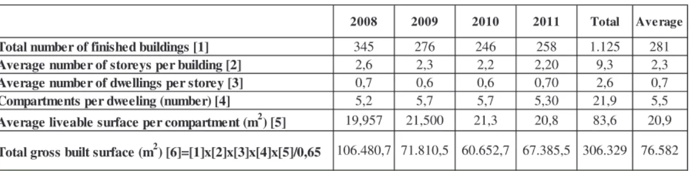
In order to assess the average municipal price/m2 based on market transactions, the average gross built up surface was first computed for the municipality of Ourém (INE, 2009, 2010, 2011, 2012) (Table 7):
• Collection of statistical data concerning the total number of buildings concluded annually [1] (new construction, and buildings´ enlargement, changes or reconstruction) for a four-year period (in order to prevent situation´s variations).
• Estimation of the total liveable surface for urban uses (m2), reckoned through the product among the total number of buildings concluded annually [1], the average number of floors per building [2], the average number of dwellings per floor [3], the average number of compartments per dwelling [4], and the average liveable surface per room (expressed in m2) [5].
• The total gross built surface (m2) [6] is, thus, approached by the division of the total average liveable surface by 0,65, considering that the liveable surface usually amounts to approximately 65% of the gross surface.
Table 7. Estimation of the average annual gross built surface of the municipality of Ourém for 2008, 2009, 2010 and 2011, and correspondent annual average value (Source: INE, 2009, 2010,
2011, 2012; author)
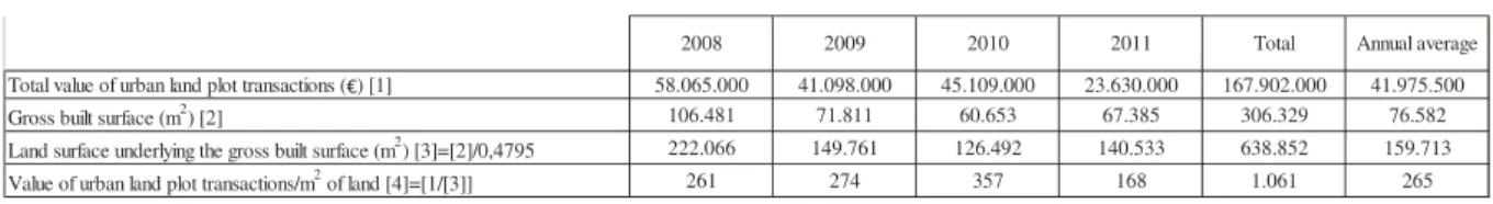
Then the average land price/m2 based on market town property transactions of the municipality of Ourém was computed the following way, for each of the considered years (INE, 2009, 2010, 2011, 2012) (Table 8):
• Collection from the Statistical Yearbooks of the central region of the total amounts of town property traded during 2008, 2009, 2010 and 2011 (€) [1];
2008 2009 2010 2011 Total Average
Total number of finished buildings [1] 345 276 246 258 1.125 281
Average number of storeys per building [2] 2,6 2,3 2,2 2,20 9,3 2,3
Average number of dwellings per storey [3] 0,7 0,6 0,6 0,70 2,6 0,7
Compartments per dweeling (number) [4] 5,2 5,7 5,7 5,30 21,9 5,5
Average liveable surface per compartment (m2) [5] 19,957 21,500 21,3 20,8 83,6 20,9
• In order to compute the average land price/m2, the built surface is, then, expressed as a function of the land underlying surface (m2). In the current case it was considered that the whole gross built surface took place in level 1 urban areas (where the average gross built surface amounts to 0,4795 m2/m2 of land, using the computation methodology previously described). The land surface underlying the gross built surface [3] is, then, determined through the quotient between the gross built surface [2] and that building capacity;
• Finally, the average land price/m2 [4] is given by the quotient between the value of town property transactions [1] and the land surface underlying the effective gross built surface [3].
Table 8: Estimation of the average land price/m2 in the municipality of Ourém for 2008, 2009, 2010 and 2011, and correspondent annual average value (Source: INE, 2009, 2010, 2011, 2012;
author)
Thus the average annual land transaction cost is 265 €/m2 of land.
3.4. Computation of the 20% tax on the increase in land value that accrues from the implementation of the Detail Plan of Avenida Papa João XXIII
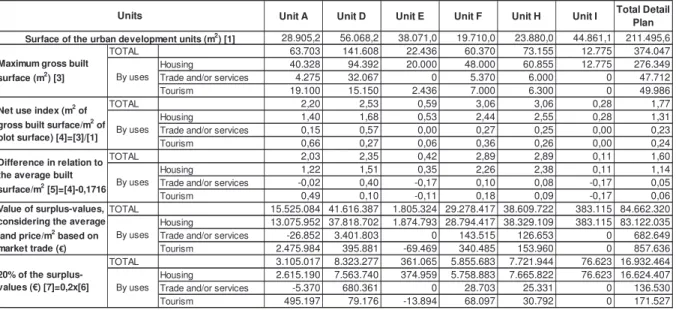
The following methodology was pursued in the computation of the 20% tax on the difference between the values of the concrete gross built surface/m2 licensed by the Detail Plan of Avenida Papa João XXIII, and the abstract average built surface/m2 in the municipality Ourém:
• Determination of the net occupation index per m2 of each urban development unit [4], through the quotient between the gross built surface for profitable uses4 [3] and the plot surface [1];
• Computation of the difference [5] between the net occupation index/m2 of each urban development unit for each kind of use [4] and the municipal abstract average built
4 Profitable uses include housing, trade, services and tourism.
2008 2009 2010 2011 Total Annual average
Total value of urban land plot transactions ( ) [1] 58.065.000 41.098.000 45.109.000 23.630.000 167.902.000 41.975.500
Gross built surface (m2) [2] 106.481 71.811 60.653 67.385 306.329 76.582
Land surface underlying the gross built surface (m2) [3]=[2]/0,4795 222.066 149.761 126.492 140.533 638.852 159.713 Value of urban land plot transactions/m2 of land [4]=[1/[3]] 261 274 357 168 1.061 265
surface/m2 (0,1716 m2 of gross built surface/m2 of land in the whole developed and developable municipal urban surface);
• The surplus values considering the average municipal land price/m2 based on market town property trade [6], is assessed through the product between the value of the difference in relation to the municipal average built surface/m2 [5], the land price/m2 based on market trade (265 €/m2), and the maximum licensed gross built surface [3];
• 20% of the amounts of these surplus values [7] are finally computed (Table 9).
Table 9: Computation of 20% of the surplus values that result from the assignment of a building right higher than the municipal average built surface/m2 in each of the urban development units of the Detail Plan of Avenida Papa João XXIII, in Fátima (Source: author)
The presented reasoning, considering the average town property land price/m2 in the municipality of Ourém, leads to the conclusion that the surplus values that accrue from the assignment of a building right higher than the municipal average built surface/m2 amount to 84 662 320 euros. Herein is proposed the collection of a 20% tax on this value that, for the urban development intervention covered by the current Detail Plan, amounts to 16 932 464 euros.
Unit A Unit D Unit E Unit F Unit H Unit I Total Detail Plan
28.905,2 56.068,2 38.071,0 19.710,0 23.880,0 44.861,1 211.495,6
TOTAL 63.703 141.608 22.436 60.370 73.155 12.775 374.047
Housing 40.328 94.392 20.000 48.000 60.855 12.775 276.349
Trade and/or services 4.275 32.067 0 5.370 6.000 0 47.712
Tourism 19.100 15.150 2.436 7.000 6.300 0 49.986
TOTAL 2,20 2,53 0,59 3,06 3,06 0,28 1,77
Housing 1,40 1,68 0,53 2,44 2,55 0,28 1,31
Trade and/or services 0,15 0,57 0,00 0,27 0,25 0,00 0,23
Tourism 0,66 0,27 0,06 0,36 0,26 0,00 0,24
TOTAL 2,03 2,35 0,42 2,89 2,89 0,11 1,60
Housing 1,22 1,51 0,35 2,26 2,38 0,11 1,14
Trade and/or services -0,02 0,40 -0,17 0,10 0,08 -0,17 0,05
Tourism 0,49 0,10 -0,11 0,18 0,09 -0,17 0,06
TOTAL 15.525.084 41.616.387 1.805.324 29.278.417 38.609.722 383.115 84.662.320
Housing 13.075.952 37.818.702 1.874.793 28.794.417 38.329.109 383.115 83.122.035
Trade and/or services -26.852 3.401.803 0 143.515 126.653 0 682.649
Tourism 2.475.984 395.881 -69.469 340.485 153.960 0 857.636
TOTAL 3.105.017 8.323.277 361.065 5.855.683 7.721.944 76.623 16.932.464
Housing 2.615.190 7.563.740 374.959 5.758.883 7.665.822 76.623 16.624.407
Trade and/or services -5.370 680.361 0 28.703 25.331 0 136.530
Tourism 495.197 79.176 -13.894 68.097 30.792 0 171.527
Difference in relation to the average built
surface/m2 [5]=[4]-0,1716 By uses Value of surplus-values, considering the average land price/m2 based on market trade ( )
By uses
20% of the
surplus-values (€) [7]=0,2x[6] By uses
Units
Surface of the urban development units (m2) [1] Maximum gross built
surface (m2) [3] By uses Net use index (m2 of
gross built surface/m2 of plot surface) [4]=[3]/[1] By uses
4. CONCLUSIONS AND RECOMMENDATIONS
The study herein reported was applied to the Detail Plan of Avenida Papa João XXIII in Fátima that locates in the municipality of Ourém. It supports municipal decisions, as it renders feasible the definition of objective parameters and indicators for the computation of the collectable values this municipality could potentially achieve in the different urban development units and for the different possible kinds of uses, in the intervention area of the Detail Plan.
It can be further applied to other municipalities and intervention areas of Municipal Master Plans, Urban Development Plans or Detail Plans, as it grounds on comparable available data.
This new territorial management instrument – that consists in the collection of a 20% tax on the increase in land value (surplus values) that accrues from the assignment of a building right higher than the municipal average built surface/m2:
• Assesses in a clear and objective way, the allowed average gross built surface/m2 of specific urban developments, in comparison with the municipal average gross built surface/m2;
• Enables the capture of part of the surplus values that arise from planning decisions or public investments, so that municipalities can reassign them to social purposes (Rebelo, 2013);
• Assures that the surplus values that accrue from urban operations and from municipal planning decisions are allocated for the population´s general social interest and not for private-oriented specific interests;
• Warrants a fair equity among the whole population living in a certain Municipality, in what concerns the distribution of benefits and charges that accrue from urban development processes.
• Clears up municipal funds´ origins and applications that accrue from urban development, and, thus, objectively quantifies the concrete obtainable contribution values.
• Reinforces municipal economic and financial sustainability.
It can in all thus be concluded that the new planning and territorial management paradigm, namely in what concerns the economic and financial sustainability of territorial plans (especially
through this new instrument), will substantially support the urban development and enhance populations´ quality of life.
References
Alexander, G.; Penalver, E. M., Singer, J. W. and Underkuffl, L. C. (2009), “A Statement of Progressive Property”, Law Review, Vol. 94, 743-744
Alterman, R. (2011), “Is capturing the "unearned increment" in land value still a viable idea? A cross-national analysis”, COBRA 2011 - Proceedings of RICS Construction and Property Conference, pp. 1233-1252
Alterman Rachelle (2010), “Takings International: A Comparative Perspective on Land Use Regulations and Compensation Rights”, Chicago: American Bar Association Publications
Correia, P. (1993), Políticas de solos no planeamento municipal, Edição da Fundação Calouste Gulbenkian, Lisboa, 403 pp.
DGOTDU (2011), “Preparação do projecto da nova Lei do Solo: Workshop com especialistas”, Documento de apoio ao debate, Lisboa.
Hagman, D. G.; and Misczynski, D. J. (Eds.) (1978), “Windfalls for Wipeouts: Land Value Recapture and Compensation”, Chicago: American Society of Planning Officials
Hong, Y. (1998), “Transaction Costs of allocating increased land value under public leasehold systems: Hong Kong”, Urban Studies, Vol. 35, nº 9, pp. 1577-1595
http://www.dgotdu.pt/ http://www.google.pt/
Ingram, G. K. and Hong, Y-H. (2007), Land Policies and Their Outcomes, Cambridge, MA: Lincoln Institute of Land Policy. Leman, 464 pp.
Instituto Nacional de Estatística, I. P. - Anuário Estatístico da Região Centro 2008, Lisboa. Portugal, 2009. www.ine.pt
Instituto Nacional de Estatística, I. P. - Anuário Estatístico da Região Centro 2009, Lisboa. Portugal, 2010. www.ine.pt
Instituto Nacional de Estatística, I. P. - Anuário Estatístico da Região Centro2010, Lisboa. Portugal, 2011. www.ine.pt
Instituto Nacional de Estatística, I. P. - Anuário Estatístico da Região Centro 2011, Lisboa. Portugal, 2012. www.ine.pt
Legislation:
Aviso n.º 2766/2009 (simplified change of the Urban Development Plan of Fátima) Aviso n.º 5416/2009 (ratification of the Municipal Master Plan of Ourém)
Aviso n.º 18200/2009 (new ratification of the Municipal Master Plan of Ourém and of the Urban Development Plan of Fátima)
Aviso nº 15622/2009, de 4 de Setembro (Detail Plan of Avenue Papa João XXIII)
Aviso n.º 11779/2010 (adjustment of the Municipal Master Plan of Ourém to the Regional Plan of Territorial Ordering of West and Tagus Valley (PROTOVT)
Aviso n.º 7841/2011 (changing in the ratification of the adjustment of the Municipal Master Plan of Ourém to the Regional Plan of Territorial Ordering of West and Tagus Valley (PROTOVT))
Aviso n.º 4735/2013 (change in the National Environmental Reserve map of Ourém) Aviso n.º 4800/2013 (modification in the plan for Pias Longas site)
Declaração nº 376/99, de 17 de novembro (alteration of the Detail Plan of Caridade) Declaração de Retificação n.º 1614/2010, de 12 de agosto (ratification of the adjustment of the Municipal Master Plan of Ourém to the Regional Plan of Territorial Ordering of West and Tagus Valley (PROTOVT))
Resolução do Conselho de Ministros nº 159/2000, de 20 de novembro
Despacho nº 195/91, de 3 de Dezembro de 1991 (Detail Plan of the industrial area of Casal dos Frades).
Portaria nº 496/93, de 10 de maio (Detail Plan of Caridade)
Portaria nº 190/97, de 20 de março (Detail Plan of the Health Centre of Ourém). Portaria nº 445/97, de 7 de julho (alteration of the Detail Plan of Caridade)
Portaria nº 67/99, de 28 de janeiro (Detail Plan for the block formed by Rua Francisco Marto, Estrada da Lomba de Égua and Rua do Mercado)
Proposta de Lei nº 183/XII (Proposal of the New Basis Law of Land Policy, Territorial Ordering and Urbanism)
Resolução do Conselho de Ministros n.º 148-A/2002 de 30 de dezembro (Municipal Master Plan of Ourém)
Resolução do Conselho de Ministros n.º 148-B/2002 de 30 de dezembro (Revision of the Urban Development Plan of Fátima)
Resolução do Conselho de Ministros nº 159/2000, de 20 de novembro (Detail Plan of Quinta do Ribeirinho)
McCluskey, W. J. and Franzsen, R. C. D. (2005), “Land Value Taxation: An Applied Analysis”, Aldershot, UK: Ashgate.
Netzer, Dick (1998) “Land Value Taxation: Could It Work Today?”, Land Lines, Vol. 10 (2), 1-12
Rebelo, E. M. (2014), “Municipal average building capacity: a strategic instrument for economic and financial sustainability of urban developments”, ISUF 21st International Seminar on Urban Form, Porto, Portugal
Rebelo, E. M. (2013), ‘Perequação Urbanística a Nível Municipal: um Contributo para o Reforço das Finanças Municipais’, II Conferência em Planeamento Regional e Urbano, VIII ENVPLAN, XIII WORKSHOP APDR, Conferência Internacional “Europa 2020, retórica, discursos, política e prática”, Aveiro, Portugal
Rebelo, E. M. (2012), “Planning to fight speculation: outstanding influences on land rent”, in Agricultural Economics: New Research, Tomas H. Lee (Ed.), Chapter 4, pp. 89-111, Nova Science Publishers
Rebelo, E. M. (2009), “Land Economic Rent Computation for Urban Planning and Fiscal Purposes”, Land Use Policy, Vol. 26(3), pp.521-534
Skaburskis, A. and Qadeer, M. (1992), “An Empirical Estimation of the Price Effects of Development Impact Fees”, Urban Studies, Vol. 29, pp. 653-667
Smolka, M. O. and Amborski, D. (2007), “Value Capture for Urban Development: An Inter-American Comparison.”, Working Paper, Lincoln Institute of Land Policy
Smolka, M., and Amborski, D (2003), “Recuperación de plusvalías para el desarrollo urbano: una comparación inter-americana”, EURE – Revista LatinoAmericana de Estudios Urbano Regionales, Vol. 29, pp. 55-77.
Terraforma, Sociedade de Estudos e Projectos, Lda.; José Lamas e Associados, Estudos de Planeamento e Arquitectura, Lda. (2009) “Relatório do Plano de Pormenor da Avenida Papa João XXIII”, Câmara Municipal de Ourém.
Walters, Lawrence (2012), “Land Value capture in Policy and Practice”, Brigham Young University, World Bank Conference on Land and Poverty, Washington, DC