i
UNIVERSIDADE DE BRASÍLIA - UNB INSTITUTO DE GEOCIÊNCIAS - IG
XGIS FLEX: UM FRAMEWORK LIVRE PARA O
DESENVOLVIMENTO DE SISTEMAS DE INFORMAÇÕES
GEOGRÁFICAS PARA A WEB
MARIANO PASCUAL
DISSERTAÇÃO DE MESTRADO Nº 47
ii
UNIVERSIDADE DE BRASÍLIA - UNB INSTITUTO DE GEOCIÊNCIAS - IG
XGIS FLEX: UM FRAMEWORK LIVRE PARA O
DESENVOLVIMENTO DE SISTEMAS DE INFORMAÇÕES
GEOGRÁFICAS PARA A WEB
MARIANO PASCUAL
Orientador: Prof. Dr. George Sand Leão A. de França
Co-orientadora: Prof. Dra. Maristela Terto de Holanda
iii
Banca Examinadora:
Dr. George Sand L. Araújo de França _____________________________________ Orientador
Dr. Henrique Llacer Roig
_____________________________________
Membro Interno
Dr. Ricardo A. de Medeiros Valentim _____________________________________ Membro Externo
iv
FICHA CATALOGRÁFICA
REFERÊNCIA BIBLIOGRÁFICA
Pascual, M. XGIS Flex: um framework livre para o desenvolvimento de Sistemas de
Informações Geográficas para a web. Brasília, Instituto de Geociências, Universidade de Brasília, 2013, 62p. Dissertação de Mestrado.
CESSÃO DE DIREITOS
NOME DO AUTOR: Mariano Pascual
TÍTULO DA DISSERTAÇÃO DE MESTRADO: XGIS Flex: um framework livre para
o desenvolvimento de Sistemas de Informações Geográficas para a web.
GRAU: Mestre ANO: 2013
É concedida à Universidade de Brasília permissão para reproduzir cópias desta dissertação de mestrado e para emprestar ou vender tais cópias somente para propósitos acadêmicos e científicos. O autor reserva-se a outros direitos de publicação e nenhuma parte desta dissertação de mestrado pode ser reproduzida sem a autorização por escrito do autor.
______________________ Mariano Pascual
699.047.231-68
mariano.pascual@ibama.gov.br Pascual, Mariano
XGIS Flex: um framework livre para o desenvolvimento de Sistemas de Informações Geográficas para a web. / Mariano Pascual; orientação de George Sand. Brasília, 2013
62p.
Dissertação de Mestrado (M) – Universidade de Brasília / Instituto de Geociências, 2013
v
vi
AGRADECIMENTOS
À minha esposa Michelle Ribeiro e à minha filha Luciana Pascual, pela paciência e carinho incondicional.
Ao Instituto de Geociências - IG da Universidade de Brasília – UnB, pela oportunidade que me foi dada de encarar mais uma empreitada científica e obtenção do título de Mestre em Geociências Aplicadas.
Ao Dr. George Sand Leão Araújo de França, pelo apoio e orientação em todas as fases deste projeto de mestrado.
À Dra. Maristela de Holanda, pela orientação do trabalho e troca de conhecimentos sobre Computação.
Ao Dr. Edson Eyji Sano, pelo constante apoio e incentivo neste projeto e em outros momentos de minha carreira profissional.
vii
SUMÁRIO
CAPITULO 1 APRESENTAÇÃO, OBJETIVOS E ESTRUTURA DA DISSERTAÇÃO
1.1 Apresentação... 1
1.2 Objetivos... 1
1.2.1 Objetivo geral... 4
1.2.2 Objetivos específicos... 4
1.3 Estrutura da dissertação... 4
CAPÍTULO 2 ARQUITETURA PARA SISTEMA DE INFORMAÇÕES GEOGRÁFICAS NA WEB – WEBGIS... 6 2.1 Introdução ao artigo publicado no Geoprocessing 2012... 7
CAPÍTULO 3 XGIS FLEX: A FREE AND OPEN SOURCE FRAMEWORK FOR DEVELOPMENT OF THE GEOGRAPHIC INFORMATION SYSTEMS ON THE WEB……….. 23 3.1 Introdução ao artigo submetido à revista Journal of Brazilian Computer Society... 24 CAPÍTULO 4 CONSIDERAÇÕES FINAIS... 40
viii
RESUMO
Esta dissertação de mestrado apresenta dois estudos de caso relacionados a arquiteturas de implantação de sistemas de informações geográficas (SIG) em ambiente web que culminaram no desenvolvimento de um framework composto por um conjunto de componentes de apoio à construção de novos softwares de SIG para web. O primeiro estudo foi realizado com foco na interoperabilidade de serviços de mapas na web, contemplando principalmente as funções de consulta e disponibilização de dados em formatos diversos. Para viabilizar a troca e integração de informações espacializadas, foi necessário o desenvolvimento de alguns componentes que foram escritos sobre tecnologias proprietárias tais como Esri Flex API. Entendidas as limitações que um motor central de código fechado poderia trazer ao objeto principal do estudo, isto é, o desenvolvimento de uma arquitetura de intercâmbio de informações geográficas, surgiu a idéia de construir um conjunto de software que contornassem tais dificuldades. O segundo estudo foi realizado com foco na elaboração de um framework livre para desenvolvimento de SIG em ambiente web de padrão Rich Internet Application (RIA) e que seguisse conceitos da Web 2.0, possibilitando a indexação e visualização de dados provenientes de diferentes tipos de mídia (fotografias, vídeos, documentos) que fossem aderentes aos padrões da Open Geospatial Consortium (OGC), mas que, ainda assim, fossem possíveis de serem compartilhadas com outros formatos de dados. Este último estudo buscou ainda reduzir a complexidade e custos de implantação de projetos dessa natureza e facilitar a customização por parte de usuários finais. Ao conjunto de códigos desenvolvidos e sua arquitetura, foi dado o nome de XGIS Flex Framework.
ix
ABSTRACT
This MSc. Thesis presents two study cases related to the architectures of implementation of geographical information systems (GIS) in web environment that ended in the development of a framework composed by a set of components supporting
the preparation of new web GIS software packages. The first study was conducted focused on the interoperability of map services in the web, mainly covering the functions of consultation and release of data at varying formats. In order to enable exchange and integration of spatial information, it was necessary to develop components based on proprietary technologies like ESRI Flex API. After understanding the limitations that a central engine of closed source code could bring to the main object of study, that is, the development of an architecture for the exchange of geographic information, we came out with the idea of building a set of software that would circumvent such difficulties. The second study was conducted focusing on the preparation of a free framework for development of GIS in an environment of Rich
Internet Application (RIA) and Web 2.0 concepts. The purpose here was to enable indexing and visualization of data from different types of media (photos, videos, documents) that were adherent not only to the standards of the Open Geospatial Consortium (OGC), but also to other data formats. The latter study also sought to reduce the complexity and costs of implementation of such projects and to facilitate customization by end users. This set of developed softwares and its architecture was named XGIS Flex Framework.
1
CAPÍTULO
1-_______________________________________________________________________
Apresentação, objetivos e estrutura da dissertação.
1.1.Apresentação
Um Sistema de Informação Geográfica (SIG) é frequentemente definido como a combinação de um sistema de gerenciamento de banco de dados, um conjunto de operações de exploração de dados, e um sistema de visualização gráfica destas informações que é usado para realizar análises geoespaciais.
Muitos Sistemas de Informações Geográficas desenvolvidos para web vem sendo utilizados, entretanto, há interessantes desafios no que tange ao desenvolvimento e consequente implantação destes tipos de aplicação. Há inúmeras fontes de dados vetoriais e matriciais arquivadas e espalhadas mundialmente nos mais distintos formatos, ora apenas como simples arquivos, ora organizados dentro de Sistemas Gerenciadores de Bancos de Dados com suas extensões espaciais. Não suficiente a diferenciação de formatos de armazenamento quando tratamos de dados geográficos, temos ainda distintos sistemas de projeção, escalas e um grande tamanho de arquivos, quando tratamos de dados do tipo raster.
A Open Geospatial Consortium (OGC), vem atuando fortemente no estabelecimento de padrões de intercâmbio de informações oriundas de bases de dados heterogêneas. Para garantir a interoperabilidade de dados.
2
suporte a tecnologias 3D, regras topológicas e aos mais diversos tipos de objetos geográficos não são mais novidades neste tipo de software.
Há uma crescente popularização no acesso e uso de SIGs para web em curso neste momento, softwares tais como Google Maps, Google Earth, Microsoft Bing Maps, Yahoo Maps e OpenStreet
Maps são cada vez mais comuns no cotidiano de usuários da internet. Todos estes softwares se
apresentam como bons exemplos de implementações de tecnologia Web 2.0 por meio de Rich Internet
Application (RIA). São aplicativos muito interativos e abrem a possibilidade não apenas de visualização
de informações pelo prisma espacial mas, também pela troca de informações em diferentes formatos de mídias tais como vídeos, fotografias e documentos, todos sobrepostos e indexados espacialmente aos mapas visualizados.
Neste ambiente, a comunidade de software livre vem fazendo grandes avanços, tanto em sistemas gerenciadores de bancos de dados geográficos, como em servidores de alta performance para geração de mapas interativos. Há inclusive inúmeras e muito bem elaboradas bibliotecas de apoio a construção de interfaces gráficas de SIGs para web. Produtos comerciais para desenvolvimento de SIGs são normalmente muito dispendiosos e possuem elevado conjunto de requisitos de implantação. Naturalmente, estes têm seus códigos-fonte fechados por motivos comerciais.
Neste projeto, um framework para desenvolvimento de SIGs para web de rápida e fácil
3
serviços de legendas, títulos do sistema, logotipos e logomarcas, zoom máximo e inicial da aplicação e a configuração das ferramentas individualmente disponibilizadas.
O framework possui uma camada de apresentação que serve como uma interface gráfica para
com o usuário (GUI) onde são exibidos os resultados de dados textuais e espaciais, permitindo que os usuários finais possam interagir com os serviços de back-end. Esta interface fica instalada na camada de
servidor de aplicações e se comunica com múltiplas fontes de dados por meio da camada de integração de dados; também é executada sobre o mesmo servidor de aplicações e interage com usuários finais para analisar e manipular dados provenientes de serviços de provedor de dados. A camada do servidor de banco de dados atua como provedor de dados e operações. Um conjunto de serviços remotos trabalha simu com o provedor de dados para compartilhamento de informações. Cada serviço oferece uma série de interfaces simultaneamente através das quais, o aplicativo cliente pode resgatar dados remotos e manipulá-los, assim, além dos próprios dados é possível também trazer metadados, legendas e resultados de operações.
A simplificação do modelo multi-camadas praticado na implantação de SIGs para web, trouxe outros resultados que vão além da necessidade de interação com inúmeros e distintos softwares dispostos como camadas e acarretou na redução de tempo de instalação destes tipos de aplicação. Outra vantagem da prosposta apresentada está no fato do framework ser de código compilado, mais seguro, e
de utilizar largamente a capacidade de processamento local da máquina cliente, tornando mais baixos os custos de instalação do lado servidor.
Buscou-se, durante todo o desenvolvimento do framework, um forte acoplamento com o servidor
4
este. Foram testados no projeto os softwares ArcGIS Server, Erdas Apollo, Geoserver e MapServer, todos com excelentes resultados de aplicação à ferramenta desenvolvida.
1.2 Objetivos
1.2.1 Objetivo geral
Desenvolver e disponibilizar um framework para o rápido desenvolvimento e implantação de Sistemas
de Informações Geográficas (SIG) para ambiente web, que seja livre, baseado nos conceitos Rich
Internet Application (RIA) e Web 2.0 e nos padrões da OGC.
1.2.2 Objetivos específicos
a) Simplificar a construção de Sistemas de Informações Geográficas para web por meio da redução de camadas necessárias neste tipo de ambiente;
b) Auxiliar na rápida implantação de SIGs para web aproveitando-se do conjunto de códigos desenvolvidos;
c) Disponibilizar por meio do conjunto de códigos desenvolvidos, um ambiente pelo qual fosse possível a extensão e criação de novas classes e componentes visando a concepção de novas funcionalidades ou customização de funcionalidades já existentes no framework;
d) Tornar os usuários do framework independentes de softwares proprietários no processo de
desenvolvimento e implantação de SIGs para web; e
e) Disponibilizar uma plataforma de acesso às informações geoespaciais oriundas de serviços web de mapas de terceiros com um conjunto mínimo de ferramentas de apoio.
5
Esta dissertação foi dividida em quatro capítulos e um anexo. O primeiro deles apresenta brevemente a proposta do framework desenvolvido ao leitor, os objetivos dos desenvolvimentos
realizados e a organização do documento. O segundo capítulo, em formato de artigo, apresenta o estudo
intitulado “An Architecture for Geographic Information Systems on the Web - WebGIS” que foi
publicado na Conferência Internacional Geoprocessing 2012 em Valencia, na Espanha. No capítulo três,
é apresentado o artigo intitulado “XGIS Flex: A Free and Open Source Framework for Development of
the Geographic Information Systems on the Web”. Este por sua vez foi submetido ao Journal of the Brazilian Computer Society. O quarto capítulo traz uma síntese da relação entre os estudos e a
conclusão. Ao final, no Anexo 1, é apresentado o artigo publicado na Conferência Internacional
6
CAPÍTULO
2-__________________________________________________________________________
Arquitetura para Sistema de Informações Geográficas na Web
–
WebGIS
[Artigo publicado no Geoprocessing 2012]
7
2.1 Introdução ao artigo publicado no Geoprocessing 2012
O seguinte artigo foi publicado no Geoprocessing 2012 em Valência na Espanha e se refere à
arquitetura que foi testada e materializada por meio do desenvolvimento de um SIG para o compartilhamento e pesquisa de monografias de conclusão de curso do Instituto de Geociências da Universidade de Brasília. Este projeto aguarda a disponibilização de um ambiente computacional para sua instalação. Este trabalho resultou-se muito importante em termos de resultados de testes e foi este quem nos direcionou para a construção de um framework de apoio ao desenvolvimento de SIGs de
padrão RIA e Web 2.0 livre.
Nesta primeira versão, havíamos utilizado a API Flex da ESRI e anexa a esta, fomos desenvolvendo e estendendo um conjunto de classes e componentes utilizando Action Script dentro do
próprio Adobe FLEX SDK. Também, intercambiamos nesse desenvolvimento serviços web de mapas com distintas instituições e começamos a publicar dados que não estavam em bancos de dados geográficos de maneira espacial por meio dos serviços web criados.
Posteriormente e logo após validarmos a estrutura de interoperabilidade, começamos a estruturar o novo motor de navegação de mapas dentro do conceito de framework para desenvolvimento apoiado
de aplicações. Os códigos que antes estavam portados para a API ESRI foram adequados ao novo contexto e passaram a ganhar mais e novas funcionalidades. Com a possibilidade de alterações no motor do novo framework, foi possível adaptar-se a outros padrões de acesso a dados geográficos e a
8
An Architecture for Geographic Information Systems on the Web
–
WebGIS
Mariano Pascual, Eluzai Alves, Tati de Almeida, George Sand de França, Henrique Roig
Geosciences Institute University of Brasilia, UnB
Brasilia, Brazil mariano.pascual@ibama.gov.br
Maristela T. Holanda
Department of Computer Science University of Brasilia, UnB
Brasilia, Brazil mholanda@cic.unb.br
Abstract - Geographic Information Systems for the web (webGIS) are being implemented for different purposes. In this context, one of the greatest challenges is to integrate different sources of geographic data, as well as the visualization of this information using maps in an interactive environment. This paper presents a proposal for architecture for the webGIS with interoperability between different sources of heterogeneous data, as well as the visualization of maps in different formats with components implemented with Web 2.0 technology. The architecture was validated through a case study that implemented a webGIS to academic research at the Geosciences Institute of the University of Brasilia.
Keywords-Geographic Information System; web GIS; Geographic Database; Map Visualization.
Introduction
9
of those decisions [2][8][16][20]. GIS environments are also cartographic tools that facilitate building maps and examining the impacts of changes to the maps interactively [1][3][5][9][11][12].
Currently, GIS on the web (webGIS) is being developed, and one challenge in that environment is interoperability among heterogeneous databases. For interoperability of the data, the web services technology is being used [15]. The standard set by the OGC (OpenGIS Consrtium) proposes the open service architecture of web GIS to support data-interoperability. And, it suggests the GML (Geographic Markup Language) based on XML to exchange the data between the web client and the web GIS [6][7]. REST [22] technology is also used to support interoperability with geographical databases.
For the visualization of maps in an interactive way, Web 2.0 technology is being applied through different components of RIA (Rich Internet Application). As is observed in [10], this technology is being applied for the development of web-GIS. Web mapping applications such as Google Maps, Google Earth, Microsoft Bing Maps and Yahoo Maps are usually considered good examples of Web 2.0 [15].
This paper presents an architecture for webGIS based on Web 2.0 and interoperability among different geographical data. The architecture is based on web services and can be used with open or owner map and database servers.
The content of this paper is divided into the following sections: 2 – basic concepts about webGIS are presented; 3 – the proposed architecture is defined; 4 – related works, which are analyses; 5 – Case Study, where the architecture was used to develop the GIS for the Geosciences Institute of the University of Brasilia; and finally, 6 – the conclusions.
10
WebGIS
Web GIS is any GIS that uses Web technologies. The simplest form of webGIS should have at least a server and a client, where the server is a Web application server, and the client is a Web browser, a desktop application, or a mobile application [15][4].
With regard to the architecture of a webGIS, the architecture based on three layers is most commonly used: User Interface Layer, Application Server Layer and Database Layer [17][19][21]. Some authors considered four layers, where the integration layer is added on the architecture webGIS, which is based on web services [14].
The User Interface layer serves as a graphic user interface (GUI) to present the result of spatial data, allowing the end users to interact with the backend services
The Application Server layer communicates with multiple data sources via the data integration layer, and interacts with end users to analyze and manipulate data coming from data provider services
The Database layer of data provider services, is a set of remote data provider services for data sharing. Each data provider service offers a set of interfaces through which client applications can pull remote data in and manipulate the data.
Proposed Architecture
The model proposed (Figure 1) presents an abstract architecture for a webGIS. In this model we observe a set of classes developed that integrate with one another and servers of interoperability, and web services in the treatment and insertion of information, as well as in the availability of data for the final user.
11
use WMS, WCS or REST for the presentation of layers on the web in a single RIA application utilizing web services.
Figure 1. Abstract Model of the proposed architecture
Each component of the abstract architecture is described as follow. Shapefile Overlay
12
presented in a tabular format and related to the correspondent geometry. The features that can be viewed are: line, point, or polygon. In order to do this simply click on the tool of the folder with the zipped file containing minimally formatted .shp, .shx and dbf. Files. In case the set of files is projected in a system distinct to the map base, the inclusion of the compacted file .prj is necessary for the system to complete re-projection.
GPX Overlay
The great quantity of Garmim brand GPS field equipment users was an enormous motivator in the development of this component, which makes the overlay of files downloaded directly from equipment of this type possible. All of the waypoints available to track overlays of a line where the initial point is presented in green, the path in yellow and the end in red are presented. The attributes given to the paths are shown in a floating table.
KML Overlay
This class provides the opening and comparison of the routes generated in Google Map platforms, and also in simple files in KML format, the available attributes in the referred to file are also presented in splints through floating panels.
Vectorization
The class that serves vectorization and release in distinct database formats such as lines, points and polygons. Algorithms for the calculation of the area and perimeter are also in this class, if sending to the database is not necessary, the user can opt to save the designed features on a local disc.
Graphics
13 Exporting Data
Totally integrated components or Geoserver Java interactive server maps, can be made through this class, with the selection and later exportation and download of layers or a part of them in diverse formats such as shapefile, csv. Pdf. Xls. Kml. Kmz. Jpg. Png and others.
Buffer with Spatial Query
Tools of bufferization through which complete features or a part of their registers can be used to create buffers. After the conclusion of this step the user of the class can once again select features, however, now to execute special queries about the buffer presented on screen. The result presented can be saved so that it is not necessary to complete the whole process again.
Google Street View Integration
A developed component that integrates with the Google Street View Platform, so that the information can be visualized in two dimensions, and through which one can navigate on maps, in addition to visualizing, in a part of the frame, the entire Google Street platform base, which always synchronizes the observation points with the street navigation.
Integrated Overlay REST and WMS
This is the most important component developed, since it makes possible the integration of different formats of interactive maps hybridizing the framework, through which one can make use of standard REST web services available through the software ArcGIS Server as well as the Geoserver and makes the overlay transparent to the user of standard WMS and WFS web services.
Navigation and Data Tabs
A component of presentation and formatting grids was built aimed at improving the visual aspect of register lists extracted from the database. There is a great interaction between the navigation and consultation of attributes related to the geometry visualized.
14
This component aims at adopting the tool of a set of classes capable of treating incoming information from the interface that will be sent to the database, and through this one can select which type of database will be used and the classes will be the interactions necessary for a correct treatment of distinct types between the manufacturers of SGBDs. Treatment of Geographic Features: set with the minimum rules necessary to avoid classical errors at the moment of vectorization, such as the creation of polygonal ties. Through this, perimeter and area are also calculated and different symbologies can be attributed to the design features, such as, completing the recording in databases or in the text format to be saved in a locale and overlay.
Development of the Architrcture
For the development of the SIG, various program languages were chosen, including: Flex, Action Script, PHP , Java Script and Ajax. Java programming language was used in the customizations done for the Geoserver software, and was the same language in which the software was written.
15
Related Work
The proposal presented in this paper is the architecture of webGIS, which has the characteristic of components based on web 2.0 for visualization of spatial data. Our proposal has a layer of interoperability with free and own mapping server and different Geo-DBMS.
Shunfu Hu [19] presented an architecture for development web-based GIS applications. The webGIS was based on Microsoft Visual Basic. Microsoft Internet Information Server (MIIS) was employed as web Server and ESRI MapObjects Internet map Server as map Server. Unlike our proposal, the architecture present in [19] is not interoperable.
Boucelma et al presented [1] a WFS-based mediation system for GIS interoperability. The functional architecture of the geo- graphic mediation system is mainly composed of three layers: a GIS mediator, Web Feature Servers (WFS) and data sources. In [1] the integration of query capabilities available at the sources and a geographical query language to access and manipulate integrated data is addressed. Differently, our architecture integrates the data source and the components Treatment of Database and Buffer and spatial query.
Majchrzak and More in [10] cover how Web 2.0 technologies can be used to develop GIS through interaction with users. In [10] the aide volunteers in disaster situations is presented, using Google technologies. Our proposal is an abstract with different front-end, map server and Geo-DBMS, which can be used with Google technologies or others.
16
be accessed by many different computers in networks with different kinds of operating systems. It is a distributed, platform independent system architecture. The data are stored and managed with EJB. Frehner and Brandli [20] presented the Virtual Database that consists of a framework for web-based retrieval, analysis, and visualization of spatially related environmental data based on the integration of distributed data. This architecture is based on web services. The proposal presented in [14][18][20] has the interoperability properties, however, our proposal supports more geographic data formats.
Zongyao and Yichun proposed, in [14], a service-oriented architecture for spatial data integration (SOA-SDI) of a large number of available spatial data sources that are physically sitting at different places, of which the development web-based GIS systems were based on SOA-SDI, allowing client applications to pull in, analyze and present spatial data from those available spatial data sources. Lu, in [18], defined a GIS platform architecture as a multi-layer architecture that integrated the web service, Servlet/JSP functions and GIS APIs based on the framework of J2EE infrastructure. The GIS system can be accessed by many different computers in networks with different kinds of operating systems. It is a distributed, platform independent system architecture. The data are stored and managed with EJB. Frehner and Brandli [20] presented the Virtual Database that consists of a framework for web-based retrieval, analysis, and visualization of spatially related environmental data based on the integration of distributed data. This architecture is based on web services. The proposal presented in [14][18][20] has the interoperability properties, however, our proposal supports more geographic data formats.
Case Study
17
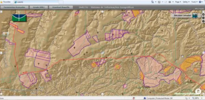
languages and technologies of the latest generation for the layer of presentation and interaction with users. In Figure 2, we present the initial vision of the system.
Figure 2. Initial View of the System
Various geographic web services are integrated, such as wind velocity and direction services of the American NOOA, with the rest platform of the ESRI as a mosaic of world images and services of maps from diverse Brazilian institutions. Thus, many services were in standard WMS and WCS, while services in standard REST were integrated guaranteeing then, a good degree of interoperability and sharing.
18
Figure 3. Zoom of detailed information of the geography mounted
The transparency of the maps can be altered and diverse layers of information of the same geographic area can be presented; this is a resource that Flex technology provides, which is useful and has great visual impact. In Figure 4, on selecting the area of the city of Rio de Janeiro we have the system fusing local data with data from web services of other institutions, such as: the Pereira Passos Urban Institute of Rio de Janeiro and the Brazilian Institute of the Environment and Renewable Natural Resources-IBAMA.
19
Figure 4. Zoom of the city of Rio de Janeiro
Figure 5. Integration Google Street View
Research tools of academic works were developed, and through these one can find scientific articles or studies completed in the research area.
20
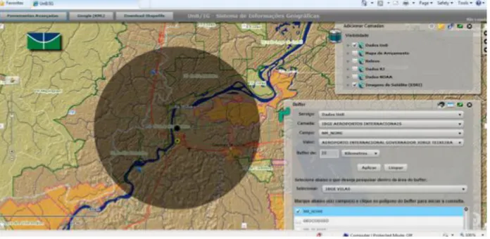
Figure 6. Buffer Tool and Spacial Query
Spatial graphic generating tools permit an evaluation of areas excessively inventoried for a determined resource or the identification of areas in need of particular studies, or identification of the needy areas of the given study, as presented in Figure 7.
21
Conclusion
The architecture presented in this paper proposes a tool of rapid implantation and availability of geographic data through the web, with a set of services made available, which can easily integrate data of structured systems such as, consumption of information originating from diverse data sources.
The architecture proposed responded well to the system of application, much as the same being used for the development of other webGIS. Recently IBAMA adopted the architecture proposed in this work in the implementation of webGIS for the monitoring of its field supervision operations; through the set of components available, the information of operations and navigation of airships and roadways, always in a geo-referenced way are presented. Similarly, the effect of agents or the quantity of apprehension and automations are informed through structured systems and presented in a spatial way on the platform.
The next step is to implement the proposal architecture independent of ESRI API.
References
[1] Boucelma, O., Essid, M. 2002. A WFS-Based Mediation System for GIS Interoperability. ACM GIS’02, November 8–9, 2002, McLean, 23-28. . DOI= http://dx.doi.org/10.1145/585147.585153
[2] Arenas, J., Zambrano, H.2009. Web-based GIS Applications for Government. In Proceedings of the 3rd ICEGOV International Conference on Theory and practice of electronic governance. (Bogota, Colombia).ACM . DOI=
http://dx.doi.gov/10.1145/1693042.1693125.
[3] Ostergren, M., Hemsley, J., Belarde-Lewis, M., Walker, S.. 2011. A Vision for Information Visualization in Information Science. iConference, Seatle, USA fev. (2011).531-537. DOI=http://dx.doi.org/10.1145/1940761.1940834.
[4] Bressan,T.. 2010. Desenvolvimento e integração de um ambiente SIGWEB com ferramentas de software livre. Master Thesis. Federal University of Santa Maria Brazil.
[5] Câmara, G., Queiroz, G. 2010. Banco de Dados Geográficos. 2010
[6] Kim, D.; Kim, M. 2002. Web GIS Service Component Based On Open Environment. In Proceedings of IGARSS Geoscience and Remote Sensing Symposium. 2002 IEEE International IEEE. pg. 3346-3348. DOI= http://dx.doi.org/10.1109/IGARSS.2002.1027178
[7] OGC 2007. OpenGIS® Geography Markup Language (GML) Encoding Standard 2007.
[8] Dragiéevié, S.; Balram, S. A Web GIS collaborative framework to structure and manage distributed planning processes. Journal of Geographical Systems. Spring-Verlag (2004) 6: 133-153. DOI= http://dx.doi.org/10.1007/s10109-004-0130-7
[9] Rhyne, M. Visualizing Geospatial Data. 2004. In Proceedings of ACM SIGGRAPH 2004. DOI=
http://dx.doi.org/10.1145/1103900.1103931
[10] Majchrzak, A.; More, P.. Emergency! Web. 2.0 the Rescue! . Communications of the ACM, April 2011, vol. 54, n. 4. Pg. 125-132.
[11] Longley, A., Goodchild, F., Maguire, J. , Rhind, J. 2005. Geographical Information Systems and Science. 2nd Edition. John Wiley &
Sons.
[12] Rigaux, P., Scholl, M.,2002. Voisard, A. Spatial Databases with Application to GIS. Elsevier Science.
22
[14] Zongyao, S., Yichun, X..2010. Design of Service-Oriented Architecture for Spatial Data Integration and Its Application in Building Web-based GIS Systems. Geo-spatial Information Science . 13, 1 (March 2010), 8-15. DOI= http://dx.doi.org/
10.1007/s11806-010-0163-7
[15] Fu, P., Sun, J. 2010. Web GIS: Principles and Applications. ESRI Press (2010).
[16] Wolfgang, R. Principles and Application of Geographic Information Systems and Internet/Intranet Technology. In Proceedings New Information Processing Techniques for Miitary Systemns. Istanbul, Turkey, October 2000.
[17] Baumann, J. 2011. Future of Web GIS: An Interview with Pinde Fu. GeoConnection International Magazine, April 2011
[18] Lu, X..2005. An Investigation on Service-Oriented Architecture for Constructing Distributed Web GIS Application. In Proceedings of IEEE International Conference on Services Computing(SCC’05). 191-197. DOI=http://dx.doi.org/10.1109/SCC.2005.27
[19] Shunfu H.. Web-Based Multimedia GIS for the analysis and visualization of spatial environmental database. In Proceedings of
Symposium on Geospatial Theory, Processing and Applications, Ottawa 2002.
[20] Philippe Tigaux, Michel O. Scholl, Agnés Voisard. Spatial databses: with application to GIS. Editora Morgan Kauffman. 2002 [21] Frehner, M., Brandli, Martin. 2006 Virtual database: Spatial analysis in a Web-based data management system for distributed
ecological data. Environmental Modelling & Software 21 (2006) pg. – 1544-1554. DOI=
http://dx.doi.org/10.1016/j.envsoft.2006.05.012
[22] Page, K., Roure, D., Martinez, K. 2011. REST and Linked Data: a match made for domain driven development? In: Proceedings of the
Second International Workshop on RESTful WS-REST 2011 March 2011; Hyderabad, India. DOI=
23
CAPÍTULO
3-__________________________________________________________________________
XGIS Flex: A Free and Open Source Framework for Development of the
Geographic Information Systems on the Web
[Artigo submetido para a revista Journal of Brazilian Computer Society]
24
3.1 Introdução ao artigo submetido à revista Journal of Brazilian Computer Society
Neste capítulo, é apresentado o artigo submetido à revista Journal of Brazilian Computer Society, que por sua vez demostra a versão atual do framework desenvolvido. O mesmo é validado por meio de
dois estudos de caso, em um deles a implantação de um SIG para a Secretaria de Planejamento e da Modernização da Gestão Pública do estado do Tocantins com apoio da JICA - Japan International Cooperation Agency e, em outro estudo com a implantação da framework e a troca por parte do Instituto
Brasileiro do Meio Ambiente e dos Recursos Naturais Renováveis (IBAMA) do ambiente similar desenvolvido em Flex da fabricante ESRI pela arquitetura e framework apresentados neste capítulo.
O framework para desenvolvimento de SIGs para web é de rápida e fácil implantação, além de
ser livre, com conceitos da Web 2.0 e da OGC, trata-se de uma aplicação RIA. Uma nova aplicação derivada do software desenvolvido não necessita de técnicos programadores de computadores no processo de customização, sendo que usuários comuns podem realizar os ajustes por meio de arquivos de formato XML. Trechos de exemplo de códigos-fonte em formato XML são apresentados neste artigo.
Outro ponto interessante da ferramenta desenvolvida é a simplificação do modelo multi-camadas praticado na implantação de SIGs para web. A arquitetura atual proposta conta com três camadas: SGBDs, Servidores de Aplicação e de Interoperabilidade, o que facilita a instalações do ambiente. Outra vantagem do apresentado está no fato do framework ser de código compilado, mais seguro, e de utilizar
25
XGIS Flex: A Free and Open Source Framework for Development of the
Geographic Information Systems on the Web
Mariano F. Pascual a,*, Maristela Holanda b, George F. Sand a, Edson E. Sano a,c
a Universidade de Brasília, Instituto de Geociências, Campus Universitário Darcy Ribeiro CEP:
70910-970 Brasília, DF, Brazil
E-mails: mariano.pascual@ibama.gov.br, georgesand@unb.br
b Maristela Terto de Holanda
Universidade de Brasília, Departamento de Ciência da Computação, Campus Darcy Ribeiro 70910-970 Brasília, DF – Brazil
E-mail: mholanda@cic.unb.br
c Edson Eyji Sano
Embrapa Cerrados, BR-020 km 18, Planaltina, DF – Brazil E-mail: edson.sano@embrapa.br
* Corresponding author
26
WebGIS was implemented in the Brazilian Institute of the Environment and Renewable Natural Resources (IBAMA). The focus here was the monitoring of deforestation and embargoed areas in Brazil.
Keywords WebGIS, Web 2.0, rich internet application, framework.
1 Introduction
A Geographic Information System (GIS) can be defined as the combination of a database management system, a set of operations for exploring data and a graphic display system that are used for geospatial analysis. GIS analyses have the main purpose to support decision making processes and to model some of the possible consequences of these decisions [1-5]. GIS can also be considered as an important geographic tool that facilitates integration of spatially-based data (maps) with non-spatial attribute data, for instance, to study impacts in the environment interactively [3] [5-9]. Ultimately, GIS has the capability of solving complex geographical problems and of deriving new and important information by integrating several existing layers.
Combining GIS with World Wide Web (WebGIS) often results in systems that simplify exchange of geographical data, provide structured information and empower users to access GIS applications without any specific software package [10]. However, a major challenge is the interoperability among heterogeneous databases [11]. The Open Geospatial Consortium (OGC) proposes an open service architecture of web-based GIS to support data-interoperability. It also suggests the use of Geographic Markup Language (GML) based on Extensible Markup Language (XML) to exchange data between web clients and WebGIS [12, 13]. The REST technology [14] is also used to support interoperability of geographical databases. For the visualization of maps in an interactive way, the Web 2.0 technology has been applied through different components of Rich Internet Application (RIA). As noted by [15], this technology has been applied for the development of WebGIS. Web mapping applications such as Google
Maps™, Google Earth™, Microsoft Bing Maps™ and Yahoo Maps™ are usually considered good examples of Web 2.0 [11].
27
The objective of this paper is to present the XGIS Flex, a framework to develop WebGIS with free and open source software, with interoperability between different sources of heterogeneous data, as well as the visualization of maps in different formats whose components are implemented with a Web 2.0 concept.
2 Geographic Information System on the web
GIS on the web refers to any GIS that uses web technologies. The simplest form of WebGIS has at least a server (web application server) and a client (a web browser, a desktop application or a mobile application) [11, 18]. The architecture of a WebGIS is most commonly based on the use of three layers: user interface layer, application server layer and database layer [19-21]. However, some authors consider four layers, where the integration layer is added on the architecture of WebGIS, which is based on web services [22].
The user interface layer serves as a graphic user interface (GUI) to present the results of spatial data, allowing the end users to interact with the backend services. The application server layer communicates with multiple data sources via data integration layer and interacts with end users to analyze and manipulate data coming from data provider services. The database layer of data provider services is a set of remote data provider services for data sharing. Each data provider service offers a set of interfaces in which client applications can input remote data or manipulate the data.
3. XGIS Flex framework
28 3.1 Components of XGIS Flex framework
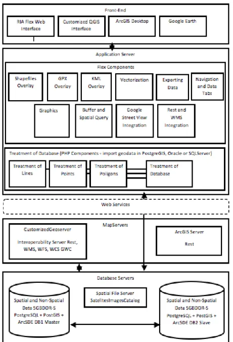
The XGIS framework is composed of components developed based on the the architecture presented by [24]. Figure 1 presents the main components of the XGIS Flex framework.
Fig. 1 Components of XGIS Flex architecture
29
available to track overlays of a line where the initial point, path and the final point are presented in different colors and the textual data are showed in a floating table. The same logics of overlay is also applied for KML format files.
The vectorization component is used for the digitizing task in the computer screen and for further record in distinct database formats (Oracle Spatial, PostGIS, SQL Server, among others). It is also possible to draw, export for local file or record directly into database as point, line or polygons. The format selected to local Record was KML. Algorithms for the calculation of the area and perimeter are also made available in the class. During the digitizing process, it is possible to add or edit new vertices and exclude former ones or all polygons, lines or points already drawn. It is also possible to add labels to the created features.
The Exporting Data Component is totally integrated with Geoserver Java MapServer. Through this component, we can also select and then export downloaded layers or part of layers in several formats such as shp, csv, pdf, xls, kml, kmz, jpg and png, in distinct systems of projection. The reprojections are always done on-the-fly through the system selected by the user of application during the conversion.
The Media Overlay is the component responsible for overlaying videos, photos and documents over maps, representing a strong Web 2.0 concept. For the development of this component, it was necessary to map and process the types of media data available in the main commercial Database Management Systems (DBMS) so that the procedures related to query and overlaying maps become possible. The written MVC PHP can retrieve, from the selected DBMS and with the use of web services, all binary files (videos, photos, text files, among others) related to geographical features selected in the computer screen, regardless of the format (point, line or polygon). In this component, we added a key parameter of access in order to avoid intercepts or undesired accesses of midia related to available features. This key is hided to users within the compiled code of Flex framework, therefore, is not possible to be accessed by web users.
30
presented in Annex A. It receives the parameters of connections and separates and considers particularities of each type of connection.
Annex B presents two parts of source code of saveWayPoints.php class. This is also part of set of codes for processing geographical data. This web service is responsible for particularities of points and lines in the PostGIS extension of the PostGRES database. The class receives the vector-based geometries, processes and records in the DBMS, returning the status of processing in the way of messages to the client users who initiated the processing.
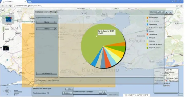
The component to generate dynamic graphics allows the construction of statistical graphs through the geographical selections. The query can be constructed by clicking the computer´s mouse in geographical objects that we desire to generate a query or by generating a polygon in an ad-hoc consultation, with single casual access and data processing, according to parameters not used yet, which, in turn, are run iteratively and heuristically. Figure 2 shows this component, highlighting the tools available to select information, a polygon generated randomly and a grid with tabular data (result of this processing step). Figure 3 presents the pie graph derived from the above mentioned selection. The following types of graphics can be derived by this component: lines, columns, bars, pie, candlestick, areas and bubbles.
31
Fig. 3 Example of graphics derived by the component to generate dynamic graphs
The Navigation and Data Tabs Component refers to the presentation component. The formatted grids are built to improve the visual aspects of register lists extracted from the database. There is a frequent interaction between the navigation and query of attributes related to the geometry visualized. The framework is composed by two basic components: the Add Points Component, in which it is possible to add points over maps, as well as the numerical or text attributes of this points. The Add Services allow the addition of web services with OGC, Web Map Services, Web Feature Services and Web Map Tile Services patterns, always on-the-fly.
3.2 XGIS to develop WebGIS
The XGIS framework was designed to be user friendly. If the user of the XGIS is not a software developer, he or she will still be able to customize an application easily and quickly, needing only to edit XML extension files. With the configuration files in XML, one can define which map services can be used, in which tables it will be possible to edit data, titles and subtitles of the system, logotypes or brands, data subtitle, symbols, and the individual configuration of each component developed.
32
between the web forms projected in the Flex environment and different types of databases. The engine was built in PHP language and deals connections with the following DBMS: MySQL, PostgreSQL, SQLite, Oracle and SQL Server and its spatial extensions, if they exist. Thus, it is possible to have an easy programming language for developing new components that interact with textual and spatial data.
The layer of data presentation always exhibits a standardized layout, making use of the application easier. This characteristics is possible because the components that were developed in Flex using ActionScript (presentation) and in PHP follow the MVC—Model, Vision and Control model. Developers have only to design the form using a graphic environment and make it available to the web service corresponding to the database tables he or she wishes to interact by using and extending the set of codes developed. It is independent of DBMS that users are utilizing, it is just necessary to modify the data that belongs to the connection, such as user, password, IP address and type of management system to be connected.
3.3 Implementation of the XGIS framework
For the development of the XGIS components, some free and open source libraries were used. The SDK Flex library [25] was one of them. This technology, have available a set of components including buttons, list boxes, tree-views, data grids, objects of text control, layout containers, graphic components, animations, status applications, modal dialogue boxes and others. The openscales libraries [26] were also widely used and an extension of the majority of the classes of the library, as well as the creation of new components and classes. The algorithm of reading of Tile Map Services derived from this library.
Other sources and free components written in ActionScript were used and organized within the XGIS framework, such as the file reading components of extensions shp, shx and dbfs and, of the watermark insertion in the application [27]. The PHP components have been completely written and this source manages the entrance of vector data that are sent by web interface such as lines, point, polygons and projection systems (input/output). Textual data are also controlled, making not only the presentation of information over maps easier, but also the insertion, alteration, exclusion and consultation of the same directly from the database.
33
Different tools for assisting the development of WebGIS with free and open source software are found in the literature and there are proprietary tools with closed sources. Some of these tools are presented as following. The ESRI makes an API for Flex [28] available for developing WebGIS with Web 2.0 characteristics, however, it is a proprietary closed source framework. A negative point is the strong linkage existing between the ESRI framework and map services originating from ArcGIS Server servers, also proprietary and costly to implement.
Google has available an environment for development in Flex, Google Maps API for Flex [29], however, it is also proprietary. The great advantage of this environment is the popularity of its base maps, which have excellent quality since Google invests heavily in the acquisition of cartographic bases, and the service provides very high performance as well. The negative points are the low quantity of available functions, presenting itself more as a compiled library to be incorporated to another Flex application and its proprietary source unalterable.
The I3Geo [30] is a web software based on a set of other free software, mainly MapServer. The main focus is the availability of geographic data and a set of tools for navigation, analysis management, on demand map sharing, and management. It is strongly linked to MapServer, free standard web services management software OGC, but from the first generation not high performing nor created for editing geographic data via web, as is Geoserver.
Four libraries are considered free frameworks for WebGIS development written in JavaScript: OpenLayers [31], GeoExt [32], OpenScales [26] and MapFish [33]. OpenLayers is a JavaScript library accessed as API, however, with an open source and one that currently presents as a library used mainly for the support and inclusion of maps on web pages, this is because of its versatility, able to adapt to diverse languages and modern web browsers. Another advantage is in the capacity of mash-ups between sources such as Google Maps, MsBingMaps, Yahoo Maps, OSM and others.
GeoExt presents itself as a JavaScritp Toolkit for Rich Web Mapping Applications that is basically an OpenLayers library, but with resources that raise the level of the applications developed, making them closer to a desktop application, while still in a web environment. Openscales is a framework written in ActionScript 3 with LGPL license type. Their libraries are widely used in our solution, but are limited to support the navigation maps.
34
applications of the type web mapping. MapFish making available a toolbook Java Script composed of Openlayers, GeoExt and ExtIS.
Differently from the libraries listed above, the XGIS is a full framework for developing WebGIS since it interacts by manipulating textual and spatial data from different DBMS, besides the possibility to render maps and pictures and to interact, as a tool Web 2.0 RIA, with photos, videos, spatial data and documents. Ultimately, the main idea of XGIS was the possibility to generate high performance applications of GIS in the web environment, easily integrated and independent of requirements of programming knowledge to implement this type of solution, always with good visual presentation.
5 Case studies
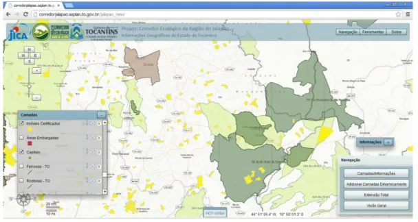
The framework was recently tested in the implementation of two WebGIS cases in the federal and state governments of Brazil. The first case was implemented in the Secretariat of Planning and Modernization of Public Management of Tocantins State (SEPLAN/TO), with the support from the International Cooperation Agency of Japan (JICA). The system was named Monitoring System of the Ecological Corridor of the Jalapão Region. The second study case was implemented in the Brazilian Institute for Environment and Renewable Natural Resources (IBAMA), and the main subject was the implementation of a new map interface of SISCOM (shared system of IBAMA, responsible, for example, for the availability of environmental information and embargoed areas).
Specifically in the case of the application of the framework of Tocantins, the set of components facilitated the integration of data from different sources. The main sources of spatial data available in Tocantins were maps in shape format, satellite images in TIF and geographical data in Oracle database with spatial extensions. A spatial database was then created using already validated dataset using PostgreSQL with spatial PostGIS software. The entire application was customized and implemented in a single day, including the creation of web map services using distinct sources of data and Geoserver. The appointments within the application are indicated using the XML extension file. Other files from the same extension were also configured, allowing changes in logotypes, brand names, title, and subtitle of the application, addresses of services and dynamic captions, among others.
35
Tabs, Layers and Menus components are being instanced together with the central engine of map navigation.
Fig. 4 WebGIS project implemented in the Tocantins State
Raster data (basically, images from the ALOS/AVNIR satellite and images from the Microsoft Bing catalogue) was overlaid with vector data. The central engine executed functions such as GetFeatureInfo and GetLegendGraphic for retrieving data regarding the layers selected. The result of the queries is always a grid when the result obtained is greater or equal to two registers.
In the IBAMA case study, the developed application supported country-based dataset. The tools for generating graphics were activated and configured to adapt the application to support system for making decisions related to deforestation and embargoed areas. Figure 5 shows a screen of the system implemented in the Center for Remote Sensing of the institute. The screen refers to a query involving display of photos and videos. In this query, the components Navigation and Data Tabs, Treatment of
36
Fig. 5 WebGIS project implemented in IBAMA, showing a example of query involving display of video and photos
6.Conclusions
Architecture presented in this paper proposed a tool of rapid implementation and availability of WebGIS, with a set of available services which can easily integrate data of structured systems, such as consumption of information originated from varying data sources. Text and vector data can be easily manipulated, making not only queries possible, but also the insertion, alteration and deletion of information directly in different types of commercial DBMS.
The display of different media (videos, photos, documents and tables) derived from spatial databases was one of the examples of Web 2.0 architecture functioning that can impress users, thanks to its high performance.
37
References
[1] Reinhardt W (2000) Principles and application of geographic information systems and internet/intranet technology. In: Proceedings of the RTO 1st Symposium on New Information Processing Techniques for Miitary Systems. Istanbul
[2] Boucelma O, Essid M, Lacroix Z (2002) A WFS-based mediation system for GIS interoperability. In: Proceedings of the 10th ACM International Symposium on Advances in
Geographic Information System (GIS’02), McLean, pp. 23-28
[3] Rigaux P, Scholl M, Voisard, A. (2002) Spatial Databases with Application to GIS. Elsevier [4] Dragiéevié S, Balram S (2004) A Web GIS collaborative framework to structure and manage
distributed planning processes. Journal of Geographical Systems, 6, 133-153
[5] Arenas J, Zambrano, H (2009) Web-based GIS applications for government. In: Proceedings of the 3rd ICEGOV International Conference on Theory and Practice of Electronic Governance, Bogota
[6] Rhyne M (2004) Visualizing geospatial data. In: Proceedings of ACM SIGGRAPH GRAPH International Conference on Computer Graphics and Interactive Techniques 2004, New York [7] Longley P A, Goodchild M F, Maguire D J, Rhind D W (2005) Geographical Information
Systems and Science. 2nd ed. John Wiley & Sons, 512 p.
[8] Ostergren M, Hemsley J, Belarde-Lewis M, Walker S (2011) A vision for information visualization in information science. In: Proceedings of iConference, Seatle, pp. 531-537
[9] Olivera H, Holanda M (2012) A GIS Web with integration of sheet and soil databases of the Brazilian Cerrado. 2012. In: Proceedings of the 7ª Conferência Ibérica de Sistemas e Tecnologias de Informação (CISTI), Madri, pp. 735-740
[10] Pessina V, Meroni, F (2009) A WebGis tool for seismic hazard scenarios and risk analysis, Soil Dynamics and Earthquake Engineering, 29, 1274–1281
[11] Fu P, Sun J (2010). Web GIS: Principles and Applications. ESRI Press.
[12] Kim D, Kim M (2002) Web GIS service component based on open environment. In: Proceedings of Geoscience and Remote Sensing Symposium (IGARSS 02), IEEE, pp. 3346-3348
38
[14] Page K, Roure D, Martinez K (2011) REST and linked data: a match made for domain driven development? In: Proceedings of the Second International Workshop on RESTful WS-REST; Hyderabad
[15] Majchrzak A, More P (2011) Emergency! Web. 2.0 the Rescue! Communications of the ACM, 54(4), 125-132
[16] Câmara G, Vinhas L, Souza C M R (2012) Free and open source GIS: will there ever be a geo-linux? In: Erwan B, Markus N (Eds), Geospatial Free and Open Source Software in the 21st Century. Springer Berlin Heidelberg, Lecture Notes in Geoinformation and Cartography, pp. 229-245
[17] Steiniger S, Hunter A (2012) Free and Open Source GIS Software for Building a Spatial Data Infrastructure. Springer
[18] Bressan T (2010). Desenvolvimento e integração de um ambiente SIGWEB com ferramentas de software livre. [MSc. thesis]. Federal University of Santa Maria, Brazil
[19] Frehner M, Brandli M (2006) Virtual database: spatial analysis in a web-based data management system for distributed ecological data. Environmental Modelling & Software, 21, 1544-1554 [20] Shunfu H (2002) Web-based multimedia GIS for the analysis and visualization of spatial
environmental database. In: Proceedings of the 2002 Symposium on Geospatial Theory, Processing and Applications, Ottawa
[21] Baumann J (2011) Future of Web GIS: an interview with Pinde Fu. GeoConnection International Magazine, April
[22] Zongyao S, Yichun X (2010) Design of service-oriented architecture for spatial data integration and its application in building web-based GIS systems. Geo-spatial Information Science, 13(1), 8-15
[23] Rao S, Sri Vinay (2010) Choosing the right GIS framework for an informed enterprise Web GIS solution. In: Proceedings of the 13th Annual International Conference and Exhibition on Geospatial Information technology and Applications, India, pp. 19 -21
39
[25] Adobe SDK Flex (2012) [cited March 2013]. http://www.adobe.com/devnet/flex/flex-sdk-download-all.html
[26] Openscales (2012) Rich maps for your applications [cited March 2013] http://openscales.org/ [27] Vanrijkom (2012) FAR (FlashArchive) [cited February 2013]
http://code.google.com/p/vanrijkom-flashlibs/
[28] ESRI (2012) ArcGIS API for Flex [cited March 2013] http://help.arcgis.com/en/webapi/flex/ [29] Google (2012) Google Maps API for Flash [cited March 2013]
https://developers.google.com/maps/documentation/flash/
[30] PSPB (2012) Portal do Software Público Brasileiro. I3GEO [cited March 2013] http://www.softwarepublico.gov.br/ver-comunidade?community_ id=1444332
[31] OSGeo (2012) OpenLayers: free maps for the web [cited March 2013] http://openlayers.org/ [32] GeoExt (2012) JavaScript toolkit for rich web mapping applications [cited February 2013]
http://geoext.org/
40
CAPÍTULO
4-____________________________________________________________________
Considerações Finais
A arquitetura e softwares apresentados neste projeto propõem uma ferramenta de rápida
implementação de Sistemas de Informações Geográficas para web, com um conjunto de serviços disponibilizados, que podem facilmente integrar dados de sistemas estruturados, com o consumo de informações provenientes de diversas fontes de dados. Dados textuais, vetoriais e matriciais podem ser facilmente manipulados, fazendo não apenas consultas possíveis, mas também a inserção, alteração e exclusão de informações diretamente em diferentes tipos de Sistemas Gerenciadores de Bancos de Dados.
A visualização de diferentes tipos de mídias indexadas espacialmente sobre os mapas, tais como vídeos, fotografias, documentos e tabelas provenientes de bancos de dados mostrou-se como um dos exemplos de conceitos Web 2.0 em funcionamento na arquitetura. Todas essas integrações foram possíveis através do motor de serviços web construído e disponibilizado no pacote de softwares do
framework.
Espera-se que a arquitetura proposta auxilie e popularize a implantação de SIGs web corporativos pela facilidade de customização dos componentes desenvolvidos e disponíveis para uso.
Até a data de 12 de março de 2013, a aplicação derivada disponível no site do IBAMA contava com 9097 visitas e está disponível no endereço http://siscom.ibama.gov.br/downloads/flex/ para download. Já
41
ANEXO 1-
__________________________________________________________________________
XGIS Flex: A Free and Open Source Framework for the Development of the
Geographic Information Systems on the Web
[artgo publicado no Geoprocessing 2013]
Abstract - Geographic Information Systems on the web (web GIS) are currently implemented for different purposes. This paper presents a framework to develop web GIS with free and open source software, for interoperability between different sources of heterogeneous data, as well as the visualization of maps in different formats with components implemented with a Web 2.0 concept. We presented two case studies that implemented a web GIS to Japan International Cooperation Agency –
42
A.1 Introdução ao artigo publicado no Geoprocessing 2013
Neste anexo, apresento o artigo publicado no Geoprocessing 2013 em Nice na França. Este artigo serviu de base para a construção do artigo submetido ao Journal of the Brazilian Computer Society e apresenta uma versão do framework que ainda não dispunha de instrumentos mais complexos de
vetorização e inserção de dados geográficos por meio da interface web, assim como, suportava menos formatos de intercâmbio de informações.
Outro e importante componente que estava em desenvolvimento e atualmente está disponível com mais funcionalidade e modelos de gráficos no framework é o componente de geração de gráficos