GEOSPATIAL DATA HARMONIZATION FROM
REGIONAL LEVEL TO EUROPEAN LEVEL
A Use Case in Forest Fire Data
Kaori Otsu
A thesis submitted in partial fulfillment of the requirements for the degree of Master of Science in Geospatial Technologies
February 2010
Universitat Jaume I (UJI), Dept. Lenguajes y Sistemas Informáticos (LSI), Spain Westfälische Wilhelms-Universität Münster (WWU), Institute for Geoinformatics
(IFGI), Germany
Dissertation supervised by
Ms. Laura Díaz Sánchez Research Associate
Department of Information Systems Universitat Jaume I
Av. Vicente Sos Baynat s/n 12071 Castellón, Spain
E-mail: [email protected]
Dr. Sven Schade Postdoctoral Researcher
European Commission, Joint Research Centre Institute for Environment and Sustainability
Spatial Data Infrastructures Unit, TP 262 Via E. Fermi, 2749, I-21027 Ispra (VA), Italy
E-mail: [email protected]
Prof. Miguel de Castro Neto Professor
Instituto Superior de Estatística e Gestão de Informação Universidade Nova de Lisboa
ACKNOWLEDGEMENTS
I feel very fortunate that I was given this research opportunity funded by European Commission’s Erasmus Mundus Scholarship. I thank my committee members, Ms
Laura Diaz, Dr. Sven Schade, and Prof. Miguel Neto for their support with my thesis work. I owe special thanks to my supervisors Ms Diaz (regarding syntactic interoperability) and Dr. Schade (regarding schematic and semantic interoperability) for their significant contributions, insightful advices, and editorial time.
I also appreciate collaboration from European Forest Fire Information System (Mr. Cristiano Giovando at Joint Research Centre) and the Valencia government (Mr. Jorge Suarez at Conselleria de Medi Ambient, Aigua, Urbanisme i Habitatge) for providing GIS data and consulting the data content regarding burned areas. In addition, Prof. Mar Marcos at Universitat Jaume I kindly guided me in ontology engineering.
ABSTRACT
Geospatial data harmonization is becoming more and more important to increase interoperability of heterogeneous data derived from various sources in spatial data infrastructures. To address this harmonization issue we present the current status of data availability among different communities, languages, and administrative scales from regional to national and European levels. With a use case in forest data models in Europe, interoperability of burned area data derived from Europe and Valencia Community in Spain were tested and analyzed on the syntactic, schematic and semantic level. We suggest approaches for achieving a higher chance of data interoperability to guide forest domain experts in forest fire analysis. For testing syntactic interoperability, a common platform in the context of formats and web services was examined. We found that establishing OGC standard web services in a combination with GIS software applications that support various formats and web services can increase the chance of achieving syntactic interoperability between multiple geospatial data derived from different sources. For testing schematic and semantic interoperability, the ontology-based schema mapping approach was taken to transform a regional data model to a European data model on the conceptual level. The Feature Manipulation Engine enabled various types of data transformation from source to target attributes to achieve schematic interoperability. Ontological modelling in Protégé helped identify a common concept between the source and target data models, especially in cases where matching attributes were not found at the schematic level. Establishment of the domain ontology was explored to reach common ground between application ontologies and achieve a higher level of semantic interoperability.
ACRONYMS
ArcIMS Arc Internet Map Server
CMA Conselleria de Medio Ambiente, Agua, Urbanismo y Vivienda (Ministry of Environment, Water, Urban Planning and Housing)
CSW Catalogue Service
DOLCE Descriptive Ontology for Linguistic and Cognitive Engineering
EEA European Environmental Agency
EFDAC European Forest Data Centre
EFFIS European Forest Fire Information System
EFICP European Forest Information and Communication Platform
ETL Extract, Transform, Load
FAO Food and Agriculture Organization of the United Nations
FIS Forest Information System
FME Feature Manipulation Engine
FRA Forest Resources Assessment
GIS Geographic Information System
GML Geography Mark-up Language
IDEE Infraestructura de Datos Espaciales de España (Spatial Data Infrastructure of Spain)
IGN Instituto Geográfico Nacional (National Geographic Institute)
INSPIRE Infrastructure for Spatial Information in Europe
JRC Joint Research Centre
MMA Ministerio de Medio Ambiente, y Medio Rural y Marino (Ministry of Environment, and Rural and Marine)
NUTS Nomenclature of Territorial Units for Statistics OGC Open Geospatial Consortium
OWL Web Ontology Language
RDF Resource Description Framework
SDI Spatial Data Infrastructure
SIOSE Sistema de Información sobre la Ocupación del Suelo en España (Land Cover Information System in Spain)
WCS Web Coverage Service
WCTS Web Coordinates Transforming Services
WFS Web Feature Service
WMS Web Map Service
WPS Web Processing Service
WSML Web Service Modeling Language
TABLE OF CONTENTS
ACKNOWLEDGEMENTS ... iii
ABSTRACT ... iv
ACRONYMS ... v
TABLE OF CONTENTS ... vi
LIST OF TABLES ... viii
LIST OF FIGURES ... ix
1. INTRODUCTION ... 1
1.1 Motivation ... 2
1.2 Research Problems and Questions ... 3
Syntactic Interoperability ... 4
Schematic and Semantic Interoperability ... 5
1.3 Testing Approach and Expected Results ... 5
Testing Syntactic Interoperability ... 6
Testing Schematic and Semantic Interoperability ... 6
1.4 Thesis Structure ... 7
2. BACKGROUND ... 8
2.1 Standard Web Services in Spatial Data Infrastructures ... 8
2.2Geospatial Data Harmonization... 10
2.3Data Transformation Tools for Schema Mapping ... 12
2.4 Ontology Languages and Reasoning ... 13
2.5 Related Research on Ontology-Based Schema Mapping ... 15
3. CURRENT STATUS OF FOREST DATA AVAILABILITY ... 18
3.1 Current Situation in Europe ... 18
3.2 Current Situation in Spain ... 20
3.3 Current Situation in Valencia Community ... 22
4. METHODS FOR TESTING INTEROPERABILITY ... 23
4.1 Syntactic Interoperability Testing ... 23
4.1.1 Tools Available for Testing ... 24
4.1.3 Quantitative Analysis ... 26
4.2 Schematic and Semantic Interoperability Testing ... 26
4.2.1 Linguistic Matching Approach on the Schematic Level ... 28
4.2.2 Ontology-Based Matching Approach on the Semantic Level ... 29
4.2.3 Ontology-Based Schema Mapping ... 30
5. RESULTS ... 32
5.1 Data Availability and Syntactic Interoperability ... 32
5.1.1 Forest Cover Data ... 32
5.1.2 Forest Fire Data ... 33
5.1.3 Burned Area Calculations ... 34
5.2 Ontology-Based Schema Mapping ... 36
5.2.1 Name Matching Attributes ... 36
5.2.2 Ontology-Based Matching Attributes ... 37
5.2.3 Schema Mapping Operations... 42
6. DISCUSSIONS AND RECOMMENDATIONS ... 45
6.1 Issues of Syntactic Interoperability ... 45
6.2 Issues of Schematic Interoperability ... 46
6.3 Issues of Semantic Interoperability ... 47
7. CONCLUSIONS AND FUTURE WORK ... 49
REFERENCES ... 52
LIST OF TABLES
LIST OF FIGURES
Figure 1. Testing approach to syntactic interoperability, and schematic and
semantic interoperability. ... 6
Figure 2. Components for spatial data integration over the Web. ... 10
Figure 3. Conceptualization of forests in a taxonomic structure. ... 14
Figure 4. Protégé user interface with a description of the concept of ‘Forests’. ... 15
Figure 5. Harmonized assessment in a nested forest information system. ... 18
Figure 6. The workflow of interoperability testing for forest data models. ... 23
Figure 7. Venn diagram illustrating differences in burned areas mapped by CMA and EFFIS. ... 26
Figure 8. Linguistic matching approach to schematic interoperability. ... 29
Figure 9. Ontology-based matching approach to semantic interoperability. ... 30
Figure 10. Ontology-based schema mapping rules for schema transformation. . ... 31
Figure 11. GIS overlay image of burned areas in Valencia Community mapped by CMA (solid polygons) and EFFIS (solid lines) at scale 1:20 000. ... 35
Figure 12. Name matching attributes from source to target data using the FME. .. 37
Figure 13. Equivalent and similar classes inferred by reasoner in Protégé for name-matching attributes. ... 38
Figure 14. Similar classes inferred by reasoner in Protégé for attributes based on forest types. ... 40
Figure 15. Establishment of the new shared concept between application ontologies based on the domain ontology. ... 41
Figure 16. Ontology-based matching attributes mapped in the FME. ... 42
1.
INTRODUCTION
Over the past two decades the distribution of geospatial data has significantly increased as information technologies advanced [Masser 2005]. As the data often derive from different sources, it is necessary to establish a common framework for sharing and exchanging data [INSPIRE 2004]. The common framework can be designed in a spatial data infrastructure (SDI) [Nebert 2004] where geospatial data can be readily accessible in cooperation with various stakeholders including governments, organizations and private sectors through agreed policies and common standards [Phillips et al. 1998]. Today, SDI plays a key role to support users and providers for decision making where they can discover, visualize, and evaluate geospatial data at regional, national and global levels [Nebert 2004; Masser 2005]. Geospatial data in an SDI include various products and services ranging from security, census, environment, health, emergency response, transportation, agriculture to forestry [Masser 2005]. In this context data harmonization is becoming more and more important to increase interoperability of heterogeneous data in a SDI [INSPIRE 2007].
In case of forestry, geospatial data are essential for monitoring and managing forests to be sustainable. At the European level, European Forest Data Centre1 (EFDAC) is under development to improve a Forest Information System (FIS). EFDAC is being implemented in compliance with the guidelines of the Infrastructure for Spatial Information in Europe2 (INSPIRE), which attempts to establish common standards in an SDI to make different SDI nodes interoperable with each other in Europe [INSPIRE 2003]. Upon implementation, the European FIS will enhance data harmonization and improve the efficiency of data collection. At national level, Spain is a Member State of European Union which is nowadays adopting the INSPIRE Directive to be compliant with it at different administrative
1
European Forest Data Centre. European Commission Joint Research Centre. URL: http://efdac.jrc.ec.europa.eu (last accessed on December 1st 2009).
2
level, being the Spanish national SDI (IDEE3) as the main node connected to the Directive. While IDEE contains basic forest cover data, the Ministry of the Environment and Rural and Marine4 (MMA) are currently attempting to allow other forest data managed by the national forestry program accessible in the IDEE [MMA 2009a]. At regional level, forest data collected from autonomous regions in Spain are accessible through the national forestry program [MMA 2009a].
The INSPIRE Directive aims to regulate various spatial data themes needed for environmental applications [INSPIRE 2003]. To date guidelines for INSPIRE Data Specifications on some data themes have been established such as protected sites [INSPIRE 2009a] and transport networks [INSPIRE 2009b]. To interoperate FISs in Europe, data specifications on forestry need to be defined in the same manner, which is addressed as one of ongoing projects by INSPIRE [INSPIRE 2003]. Thus, we intent to investigate the status quo of forest data at different administrative levels and how they can be harmonized within Europe for forest domain experts to enhance analysis.
1.1 Motivation
Increasing interoperability can help create a seamless global FIS where regional, national, and global systems are better interconnected. For example, under the initiative of Food and Agriculture Organization of the United Nations5(FAO), Global Forest Resource Assessment requires reports from each country on forest health and productivity [FAO 2009]. The global FIS is expected to enhance the efficiency of data collection and contribute to monitoring and managing forests efficiently from regional to global scales.
Using the common thematic forest data, our research aims to test data harmonization on different levels of interoperability in different scales within Europe. As the most fundamental forest data in a FIS, forest cover is available in
3
Infraestructura de Datos Espaciales de España. Gobierno de España. URL: http://www.idee.es (last accessed on November 17th 2009).
4
Banco de Datos de la Biodiversidad. Ministerio de Medio Ambiente, y Medio Rural y Marino. URL: http://www.mma.es/portal/secciones/biodiversidad/banco_datos (last accessed on November 17th 2009).
5
different information systems from regional, national and European levels. Forest cover information can be used as input for the further analysis in forest fire monitoring, wildlife habitat protection, and watershed management [European Commission 2003].
One of EFDAC components, European Forest Fire Information System6 (EFFIS), mainly provides the information about fire danger forecast, hotspots and burned areas across Europe. For example, burned areas are delineated by overlay of satellite images and land cover map, which include forest cover affected by fires [JRC 2009]. At national level in Spain, a member state of EFFIS, the MMA provides an access point to regional forest fire data where each autonomous region is in charge with data collection [MMA 2009c]. Using a forest fire scenario, our intent is to guide how regional forest domain experts can perform analysis by utilizing geospatial data and applications from regional to European level. This scenario illustrates where geospatial data can be obtained and how interoperability of such data can be achieved.
1.2 Research Problems and Questions
When we refer to interoperability, there are many aspects to consider. Interoperability does not only address one type of integration but can be categorized into mainly four types: system, syntactic, schematic and semantic
[Bishr 1998; Goodchild et al. 1999]. In our research, we use a concept of geospatial data harmonization as a factor to increase interoperability in the context of syntaxes, schemas and semantics [Lehto 2007; Schade 2009]. Syntactic interoperability refers to integrating the elements in various systems such as data formats and standards. Schematic interoperability is explained by the common classification and hierarchical structure [Bishr 1998]. Semantic interoperability harmonizes meanings of terms and expression according to how the terms are named and described [Bishr 1998].
6
A. Syntactic Interoperability
Finding common means to access heterogeneous data can increase syntactic interoperability. At service level, SDI web services are implemented by using standard interfaces defined by Open Geospatial Consortium (OGC) [Percival 2003]. The most common OGC interfaces include mapping images (OGC Web Map Service [OGC 2009], WMS), manipulating geographic features (OGC Web Feature Service [OGC 2009], WFS), and manipulating grid coverages (OGC Web Coverage Service [OGC 2009], WCS). When multiple data layers are not accessible together via web services, Geographic Information System (GIS) software applications at client level, which support different formats, are other tools to achieve syntactic interoperability.
As the central point at European level, EFFIS is playing an important role to provide web services to the public with the updated forest fire information across Europe. EFFIS manages extensive datasets produced by the JRC7 and individual national forestry programs of member states [EuroGEOSS 2009]. In theory, the geospatial data mapped by JRC and national forest fire programs should be consistent for describing the same area. In reality, when the data come from different sources in different standards and formats, they do not always match [EuroGEOSS 2009; HUMBOLDT 2009]. To examine the status of current syntactic interoperability between these geospatial data in different administrative scales, we aim to answer the following questions:
Are forest fire data from EFFIS and member states syntactically
interoperable at service level and/or client level?
Are there any scale issues of forest fire data from different sources? Are
there any discrepancies in the total burned areas between EFFIS and
member states?
Approaching these questions, we define the following hypothesis:
7
Hypothesis A
By establishing standard web services and common tools, we can increase the chance of achieving syntactic interoperability between multiple geospatial data derived from different sources.
B. Schematic and Semantic Interoperability
EFFIS applies burned areas as one of input data in its forest fire model to estimate CO2 emission [JRC 2009]. In case a regional forest domain expert attempts to apply their regional data in the CO2 emission model developed by EFFIS, they cannot simply apply the burned areas derived from their region as input data. This is due to the difference in semantics and schemas used in burned area data between different communities, languages, and administrative scales. Thus, the regional data need to be harmonized into common semantics with the EFFIS data first to reclassify schemas used in regional data for establishing common schemas with EFFIS [Bishr 1998]. In cases where different languages are harmonized into one common language, the semantics and schemas used in original languages may get lost in translation as well. In terms of semantic and schematic interoperability, our research aims to answer following question:
How can forest fire data be transformed and mapped into common schemas
and semantics across different administrative scales, where the forest fire
data are heterogeneous among different communities and languages?
This question is examined against the following hypothesis:
Hypothesis B
By identifying common schemas and concepts, we can transform the regional data model to the European data model on the semantic level.
1.3 Testing Approach and Expected Results
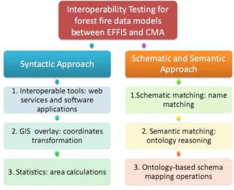
Community. Figure 1 shows the workflow of interoperability testing on the syntactic, schematic and semantic level.
Figure 1. Testing approach to syntactic interoperability, and schematic and semantic interoperability.
A. Testing Syntactic Interoperability
We test syntactic interoperability in the context of data access and format. Firstly, availability of tools that allow both data from EFFIS and Spain to be interoperable is identified in Step A1. These tools include OGC standard web services (WMS, WFS and WCS) and GIS software applications. In Step A2, the two data layers are visualized and overlaid using interoperable tools to detect any qualitative discrepancy. Step A3 then presents the quantitative difference between burned areas mapped by EFFIS and Valencia Community by area calculations. Expected outputs include a summary table of syntactic interoperability, screen shots of overlay visualization, and burned area calculations.
B. Testing Schematic and Semantic Interoperability
ontologies are established in Step B2 to identify matching attributes with a shared concept between the two data models. Finally, in ontology-based schema mapping Step B3, source data attributes from Valencia Community are transformed to the target attributes of EFFIS data according to the type of mapping operations required. Expected outputs include a table of data attributes translated from Spanish to English; ontology-based schema mapping tables from source to target data attributes; a summary of mapping operations corresponding to matching attributes; and an example of mapping rules saved as output file.
1.4 Thesis Structure
2.
BACKGROUND
In this chapter, the background information is introduced in relation to methods for testing interoperability. First, we describe how standard web services are implemented in SDIs. Second, we emphasize the importance of geospatial data harmonization for web transformation services. Then, as tools for data transformation, schema mapping software and ontology languages are introduced. Finally, we present recent researches related to ontology-based schema mapping.
2.1 Standard Web Services in Spatial Data Infrastructures
The shift in technological terms from national SDIs to multinational SDIs has been emphasized over the last decade along with the development of the World Wide Web (WWW) [Masser 2005]. Current trends in SDI development include a shift from a product to a process model where the WWW enables end users to share spatial data in decentralized structures [Masser 2005]. Another trend emphasizes implementation of multilevel SDIs in the context of hierarchy. Hierarchy can be a bottom-up as well as a top-down structure in SDI implementation. The top-down structure aims to achieve harmonization while the bottom-up structure aims to preserve heterogeneity. The challenge for implementing multilevel SDIs is to agree with a common standard in consideration with heterogeneity of various stakeholders [Masser 2005].
In Europe, the European Commission took an initiative to study the development of multinational SDIs, INSPIRE. INSPIRE Directive addresses the need for web services to discover, view, transform, invoke, and download geospatial data, which enable various stakeholders to share data in the multilevel hierarchy on the multinational scale [INSPIRE 2007]. Such web services require technical specifications commonly agreed by the Member States for the interoperability and harmonization of their SDIs [INSPIRE 2007]. Currently INSPIRE adopts the OGC specifications, existing OGC Web Services (OWS) standards, as a technical guidance for implementing those web services [INSPIRE 2008].
Transforming Services (WCTS) for transforming, Web Processing Service (WPS) for invoking, and Web Coverage Service (WCS) and Web Feature Service (WFS) for downloading [INSPIRE 2008]:
CSW supports discovery, evaluation and use of spatial data and services through their metadata properties.
WMS allows requests over geo-referenced data belonging to the themes and provides a visual representation of these data, rendered in an image format such as PNG, GIF or JPEG.
WCTS performs schema transformation and coordinate transformation. WPS provides client access across a network to pre-programmed
calculations and/or computation models.
WCS provides client access to potentially detailed and rich sets of geospatial information and returns coverages.
WFS allows clients to retrieve and update geospatial data encoded in Geography Mark-up Language (GML) [OGC 2007] from multiple WFSs. GML represents geographical features expressed in Extensible Mark-up Language (XML) that enables geospatial data to be stored, transferred, exchanged, processed and transformed though web services such as WFS and WPS in a standard format [Percival 2003; Diaz et al. 2009]. As illustrated in Figure 2, WFS plays a role of wrapper in SDIs for accessing and editing heterogeneous geospatial data in a standard way while WPS acts as a mediator for processing such data by linking WFS and data sources [Diaz et al. 2009].
Beside OGC web services, ArcIMS8 (Arc Internet Map Server) developed by ESRI offers map service and feature service using ArcXML, which follows ESRI's XML specification [ESRI 2009]. ArcIMS also provides web links of map service and feature service in the same manner as OGC WMS and WFS, however, it does not follow OGC standards.
8
Figure 2. Components for spatial data integration over the Web [Diaz et al. 2009].
2.2 Geospatial Data Harmonization
Geospatial data harmonization plays an important role for on-the-fly data transformations [Lehto 2007; Schade 2009]. To achieve interoperability via web transformation services, geospatial data need to be harmonized between different sources [INSPIRE 2007; HUMBOLDT 2008]. In Europe, HUMBOLDT projects have focused on the improvement of harmonization issues such as data format, type of web service, spatial reference system, data model, classification schemes, terms and concepts, and metadata profile, which can be harmonized on different levels of interoperability [HUMBOLDT 2008]. In our research, data harmonization refers to harmonizing heterogeneous data to achieve interoperability on the syntactic, schematic and semantic levels [Visser 2001; Stuckenschmidt 2003; Friis-Christensen et al. 2005; Lehto 2007; Vaccari et al. 2009].
retrieving burned areas and land cover via OGC WFS and transforming one of their coordinate systems via OGC WTCS (if necessary) can render the overlay image and provide statistics such as area calculations via OGC WPS for the selected area [Friis-Christensen et al. 2007].
On the schematic level, data heterogeneity is due to differences in data models and classification schemas [Friis-Christensen et al. 2005]. Geographical features such as polygons, lines, and points are often represented by different geometrical and data schemas [Vaccari et al. 2009]. Schematic interoperability can be achieved by transforming the structure of the source data model to the target source model, where the schemas refer to the respective XML Schema documents [Schade 2009]. To perform schema transformation, INSPIRE follows the ORCHESTRA Schema Mapping Service (SMS) to provide functionalities that are related to the mapping of features from a source into a target schema [INSPIRE 2008]. Specifically, schematic transformation involves filtering, renaming, reclassifying, merging/splitting, reordering, converting, morphing, and augmenting geographic features and their properties used in the schema [Lehto 2007]. This transformation is called schema mapping. In forest fire data models between source and target schemas, we may find heterogeneity in structures and attributes based on individual forest fire data standards and land cover classifications.
about data and it can contain the semantic content as well as syntactic and schematic details [Goodchild 1999]. Currently, many projects related to web services focus on semantic interoperability issues due to the complexity of semantic matching [Diaz et al. 2009]. In case of forest fire models, it is possible that the terms such as ‘forests’ and ‘burned areas’ may be defined differently between source and target data models.
2.3 Data Transformation Tools for Schema Mapping
Today spatial ETL (Extract, Transform, Load) platform is widely deployed for schema transformation in SDIs. The spatial ETL efficiently enables us to extract spatial data from source suppliers to SDI, transform the source data model to a new output in any format or application to be loaded as the target data model requested by end users [Safe Software 2009]. Data transformation for schema mapping restructures geometry and attributes, such as manipulating geometry, feature type, attribute name, attribute value, and attribute type [Safe Software 2009].
Feature Manipulation Engine (FME9) established by Safe Software is leading spatial ETL software that now is implemented in the ArcGIS Data Interoperability extension [ESRI 2009]. FME provides various data transformation functionalities including schema mapper within the geoprocessing environment. While FME is a most widely used tool, other tools such as GoPublisher10 (Snowflake Software), Spatial Data Integrator11 (Camp to Camp), and GeoXSLT12 [Klausen 2006) are currently available for schema mapping. These four tools were compared and analyzed previously [Beckman et al. 2009; Schade 2009; Chunyuan et al. 2010, forthcoming]. Key criteria include GML support, web service, GUI for mapping rule generation, support for mapping rules, and type of software [Chunyuan et al. 2010, forthcoming]. While all of them support GML as output format, only commercial
9
Feature Manipulation Engine. Safe Software. URL: www.safesoftware.com (last accessed on January 13th 2010).
10
GoPublisher. Snowflake Software. URL: http://www.snowflakesoftware.co.uk (last accessed on January 13th 2010).
11
Spatial Data Integrator. Camp to Camp. URL: http://www.spatialdataintegrator.com (last accessed on January 13th 2010).
12
tools FME and GoPublisher provide a functionality of standard web service interface for OGC WFS. SDI is open source software and offers a graphical user interface (GUI) with many built-in transformation operators as offered by FME.
2.4 Ontology Languages and Reasoning
The Semantic Web evolved from the existing WWW with the advance of knowledge representation, using machine-understandable Web content that can be processed by computer [Berners-Lee et al. 2006]. In the context of the Semantic Web, ontology plays a key role of providing a shared understanding of a domain model to harmonize the heterogeneity in terminology [Berners-Lee et al. 2006]. Domain ontology refers a shared conceptualization between different application-specific models while application ontology is only based on a local knowledge model established by the application service provider [Klien and Probst 2005; Duchesne 2008]. At the top level of ontology architecture, a foundational ontology is formalized by philosophers and cognitive engineers to link different domain ontologies [Klien and Probst 2005; Gruber et al. 2006; Duchesne 2008; Schade 2009].
2008;]. Such reasoners may be known as classifiers that compute the inferred class hierarchy [Horridge 2009]. These reasoners can be installed as a plug-in to a software application such as Protégé13, which is a platform for ontology modeling and knowledge acquisition [Knublauch et al. 2004].
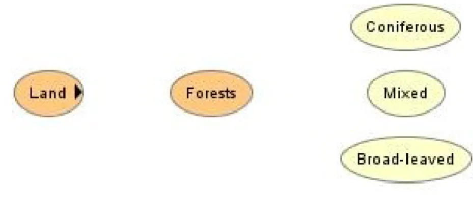
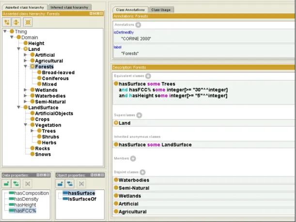
In case of defining forests, Figure 3 illustrates a simple example of conceptualizing of the class hierachy of forests. ‘Land’ is a generic class of ‘Forests’ while ‘Coniferous’, ‘Mixed’, and ‘Broad-leaved’ are more specific classes of ‘Forests’, where a taxonomic structure is indicated in the direction from left to right [Horridge 2009].
Figure 3. Conceptualization of forests in a taxonomic structure.
These concepts can be formalized as entities in Protégé. As shown in Figure 4, the entity ‘Forests’ has a class hierarchy, a description, object properties, and data
properties. A class hierarchy may be known as taxonomy and properties may be known as roles in description logics [Horridge 2009]. Object properties describe property characteristics and allow relationships between classes while data properties describe relationships between a class and data values [Horridge 2009]. ‘Forests’ is defined in Equivalent classes that have associated properties. To be classified as equivalent to ‘Forests’, all the conditions specified by object and data
properties must be sufficient. ‘Land’ is a superclass of ‘Forests’, which meets necessary conditions to become ‘Land’. In this example, provided that the necessary condition is to have surface that is some ‘LandSurface’, ‘Forests’ has surface that are some ‘Trees’ (sub-class of ‘LandSurface’). In addition, ‘Forests’ is
13
disjointed with other sub-classes of ‘Land’ so that a sample of land cannot belong to ‘Forests’ and the other sub-classes at the same time in the process of land classification [Horridge 2009]. The automated reasoner infers the class hierarchy based on these descriptions of classes.
Figure 4. Protégé user interface with a description of the concept of ‘Forests’.
2.5 Related Research on Ontology-Based Schema Mapping
This section focuses on recent research related to geospatial data harmonization through ontology-based schema mapping in order to achieve schematic and semantic interoperability.
standards-based web service environment, Lehto (2007) further categorizes schema transformations into operation components which can be applied to different levels of the GML feature model. Some of those schema operations are applied in our methods for testing schematic interoperability (Chapter 4.2)
Donaubauer et al. (2006) recognized that previous projects such as GiMoDig were only executed on the schematic level, lacking transformation between different conceptual schemas. To address this issue, they proposed the project
mdWFS based on Model Driven Architecture (MDA), which supports automated schema transformations on the semantic level. Donaubauer et al. (2007) presented a use case of mdWFS in the context of a cross-border SDI between Germany and Switzerland. They aim at implementing the prototype service in the contexts of cross-border SDI and INSPIRE, which will enable transformations guided by user-defined schema mapping. Our testing approach also addresses the issue of schema transformations on the semantic level in the context of cross-border SDI in Europe.
Using existing software applications, Friis-Christensen et al. (2005) investigated possible methods of achieving schematic and semantic interoperability of geographic data at European level. The FME was used to support transformations on the schematic level from source attributes to target attributes. This method required comprehensive knowledge of source and target schemas for all the corresponding attributes to be mapped manually. They also explored ontology-based approaches to automated schema mapping, which incorporate semantics to provide generic concepts between source and target applications. The ontology editor Protégé and the reasoner RACER were used to reclassify source and target schemas by concepts established in the domain. They found that the ontology-based classification approach by Protégé could support maximizing automation in schema mapping. In our methods for testing schematic and semantic interoperability, these existing software applications (FME and Protégé) are also used for schematic transformations and ontology-based classification.
was mainly based on attribute values at the class instance level and background ontology at the domain level. They analyzed attribute values to represent semantic details described in both schemas, which are often hidden at the schematic level. They further used comprehensive domain ontology as background ontology to match two application ontologies. The domain ontology was established by discovering relationships between source and target concepts. They are currently implementing a tool to automatically compare formal specifications and detect heterogeneities. We also take class attribute values and the domain ontology into account for testing semantic interoperability.
3.
CURRENT STATUS OF FOREST DATA AVAILABILITY
In this chapter, we describe how forest data are currently managed at the European, national and regional levels. The availability of forest data via web services is also indicated. In relation to our use case, we focus on forest cover and forest fire data from Europe, Spain, and Valencia Community respectively.
3.1 Current Situation in Europe
At European level, forest cover is identified by CORINE Land Cover Classification 2000, owned by European Environmental Agency (EEA). Land cover is classified into 44 categories where forest cover includes 3 categories: coniferous, broadleaved, and mixed [Nunes de Lima 2005].
Joint Research Centre (JRC) of the European Commission is in charge of establishing EFDAC as the central point for forest information at European level [EuroGEOSS 2009]. As a bridge of forest data flow between the world and Member States, EFDAC functions as part of a nested system for harmonized assessment to link FAO Global Forest Resources Assessment (FRA) and National Forest Inventories of Member States (Figure 5) [JRC 2009]. This way assessment can be harmonized from regional/local Forest Services to National Forest Inventories, EFDAC, and FAO Forestry.
Figure 5. Harmonized assessment in a nested forest information system [JRC 2007].
FAO Global Forestry
EFDAC
National Forest Inventories
Inventories
Data Description Source View Download
CORINE 2000
CORINE Land Cover in 2000 at 1:100 000 scale
http://www.eea.europa.eu/themes/land use/clc-download
EEA Map
Viewer
Shape
Forest Map of Europe
Pan-European forest/non-forest map with 25 m spatial resolution derived from Landsat ETM in 2000
http://forest.jrc.ec.europa.eu/download/ data/forest-map-2000-download
JRC GeoTIFF
Forest Map of Europe
Pan-European forest/non-forest with 1 km spatial resolution derived from AVHRR and forest statistics
http://efdac.jrc.ec.europa.eu/viewer/ http://efdac.jrc.ec.europa.eu/mapserv/m apserv
EFDAC Map
Viewer, WMS
European Forest Resources
Images and graphs related to forest resources in Europe
http://efdac.jrc.ec.europa.eu/index.php/ efris
JRC Map
Viewer
EFFIS Advanced Viewer
Modules include fire danger forecast, damage assessment, rapid damage assessment, EU fire database,
atmospheric emissions, and potential soil erosion. http://effis-viewer.jrc.ec.europa.eu/wmi/viewer.html JRC Map Viewer EFFIS Current Situation
Modules include recent fire danger forecast, daily MODIS, hot spot, and burned areas
http://effis.jrc.ec.europa.eu/current-situation
JRC Map
Viewer
EFFIS Fire History
Annual maps of forest burned area with minimum size of 50 ha
http://effis.jrc.ec.europa.eu/fire-history
JRC Map
Viewer
Table 1. Spatial data available for forest cover and fires in Europe [EuroGEOSS 2009].
3.2 Current Situation in Spain
Forest cover at national level is identified by Land Cover Information System known as SIOSE, the latest version of national land cover classification in Spain, under development for web services by National Geographic Institute (IGN14) [SIOSE
14
2007]. IGN also provides CORINE Land Cover map via WMS. Forest map of Spain is available based on the 3rd National Forest Inventory with 37 land cover classifications [MMA 2009b]. Table 2 shows a list of forest cover data of Spain by different sources.
Data Description Source View Download
SIOSE National Land Cover in 2005 at 1:25 000 scale
IGN
CORINE Land Cover 2000
CORINE Land Cover in 2000 at 1:100 000 scale
http://www.idee.es/wms/IGN-Corine/IGN-Corine?
IGN WMS
Forest Map of Spain (1:50 000)
Detailed forest inventory map of Spain at 1:50 000 scale
http://servicios2.mma.es/wmsconnector /com.esri.wms.Esrimap/BIODIV_MFE? Biodiversity Data Bank Map Viewer, WMS Forest Map of Spain (1:200 000)
Less detailed forest inventory map of Spain at 1:200 000 scale
http://www.mma.es/portal/secciones/bi odiversidad/banco_datos/info_disponibl e/mfe200.htm Biodiversity Data Bank Shape
Table 2. Spatial data available for forest cover and fires in Spain [EuroGEOSS 2009].
While the national FIS is not currently established in Spain, the Biodiversity Data Bank from the MMA provides geospatial data including forest inventory and management via Map Viewer and WMS [EuroGEOSS 2009]. This WMS is planned to be implemented into the National SDI, IDEE [MMA 2009a]. IDEE provides access to the main node of distributionconnected to the nodes of other web services that are established by autonomous regions. Via this main node it is possible to access national, regional, and local web services (WMS, WFS, WCS, and CSW).
3.3 Current Situation in Valencia Community
Forest cover at regional level is identified by SIOSE as the latest version, coordinated by IGN and CMA (Conselleria de Medio Ambiente, Agua, Urbanismo y Vivienda15), and the information is expected to be available in 2010 [SIOSE 2009]. Forest maps at the level of Valencia Community are accessible via Map Viewer and WMS (Table 3). These spatial data are organized in a regional SDI provided by CMA in cooperation with Valencia Cartography Institute16. The regional SDI contains a metadata catalogue system following ISO 19115 where the data models are described in a standardized format. While the WMS and CSW are well established, the datasets are not freely downloadable.
Forest fire data such as burned areas are only viewable via internal ArcIMS, which is not accessible to the public. Burned areas in Valencia Community are mapped annually, covering three provinces Valencia, Castellon and Alicante. Although spatial data of burned areas is not accessible, metadata is available via the web catalogue with a description of data attributes.
Data Description Source View Download
SIOSE National Land Cover in 2005 at 1:25 000 scale
IGN, CMA
Forest Map of Valencia ( 1:10 000)
Detailed forest inventory map in Valencia Community at 1:10 000 scale
http://orto.cth.gva.es/wmsconnector/co m.esri.wms.Esrimap/wms_invfor?
CMA Map
Viewer, WMS
Forest Map of Valencia ( 1:20 000)
Less detailed forest inventory m ap in Valencia Community at 1:20 000 scale
http://orto.cth.gva.es/wmsconnector/co m.esri.wms.Esrimap/wms_invfor?
CMA Map
Viewer,
WMS
Burned Area
Map
Burned areas in Valencia Community at 1:10 000 scale
http://intranet.cma.gva.es
CMA ArcIMS
(internal)
Table 3. Spatial data available for forest cover and fires in Valencia Community [EuroGEOSS 2009].
15
Conselleria de Medio Ambiente, Agua, Urbanismo y Vivienda, Generalitat Valenciana. URL: http://www.cma.gva.es/intro.htm (last accessed on December 13th 2009).
16
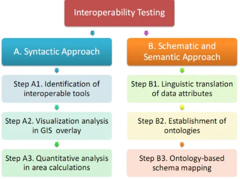
4. METHODS FOR TESTING INTEROPERABILITY
Our approach to achieving geospatial data harmonization is to test interoperability on the syntactic, schematic and semantic levels. In this chapter, we introduce the methods for testing interoperability of heterogeneous geospatial data, and relate them to the example use case on forest fire data between EFFIS and CMA. Figure 6 illustrates the workflow of testing interoperability by syntactic approach, and a combination of schematic and semantic approach. National forest fire data in Spain are collected from autonomous regions, therefore, regional data from CMA are directly tested for interoperability with the EFFIS data. Specifically, we apply burned areas for 2007 in Valencia Community mapped by CMA as source data and burned areas for 2007 in Valencia Community mapped by EFFIS as target data. After we set the scene in this chapter, results are presented in Chapter 5.
Figure 6. The workflow of interoperability testing for forest data models.
4.1 Syntactic Interoperability Testing
overlay. Burned area calculations are also provided to analyze the datasets quantitatively.
4.1.1 Tools Available for Testing
There are various tools that enable multiple data stored in different formats (e.g., shape, Mapinfo, Oracle geo-DB, and PostGIS geoDB) to interoperate syntactically [Vaccari et al. 2009]. In our methods we categorize those tools into standard web services and software applications. Using one of those tools or a combination of them, data in different formats can be displayed in a single client view. Web services implementing standard interfaces such as OGC WMS, OGC WFS and OGC WCS are often available in SDIs, providing web links for viewing and downloading geospatial data in a standardized way. Such data can be accessible via the Web or desktop software, regardless of source formats. Currently there is a number of GIS software applications, ranging from licensed applications such as ArcGIS17 spread globally, to open source applications such as gvSIG18 established by the government of Valencia Community. These up-to-date software applications enable geospatial data available in original formats or available from web services to be visualized on the fly.
Thus, we will consider that two datasets can be displayed in the same client view in the following options:
Option A - Both datasets are viewable via standard web services.
Option B - Both datasets exist locally as created or downloaded files, which can be added onto a single software application.
Option C - One dataset is added to a software interface from
existing/downloaded files while another dataset from spatial standard web services is added to the same software interface.
In our use case, EFFIS provides a web entry point with Map Viewer to display burned area data. To view the same data outside Map Viewer on the EFFIS website,
17
ArcGIS. ESRI. URL: http://www.esri.com/software/arcgis/index.html (last accessed on November 7th 2009).
18
it is not readily accessible in a standard way via web services, but available in Shape format upon request. On the other hand, burned area data from CMA is accessible via ArcIMS, which is only connected to an internal network19. Since ESRI’s map and feature services are not standard web services as OGC, accessibility is limited via ArcGIS and other software applications (e.g. gvSIG) that support in displaying ArcIMS. Assuming that we are forest domain experts who work at CMA, we would be able to add CMA data via ArcIMS and EFFIS data in Shape format, using ArcGIS (Option C). If we do not have access to the internal network, we would need to request the data from CMA, for example in Shape format, to display it in ArcGIS with EFFIS data in Shape format as well (Option B).
4.1.2 Visualization Analysis
When two data layers are visualized to locate the common area in the same client view, whether via the Web or desktop software, spatial reference systems (datum, projection) need to be interoperable so that they can be overlaid. In case of rendering images via web services, WCTS transforms the coordinates of geometric elements among different spatial reference systems [INSPIRE 2008]. In case of visualization through software applications, users are responsible for transforming spatial reference systems if they are different. This overlay visualization may show some distortion of the transformed data in terms of direction, area, and shape [Iliffe and Lott 2008]. Depending on the levels of detail contained in each data, overlay analysis can also address scale issues. For example, alignment of two data layers may not be consistent along the polygon boundaries.
We use ArcGIS to do overlay analysis between two data layers from CMA and EFFIS. As the spatial reference system (GCS_European_1950) in the source data by CMA is different from the target data, it needs to be transformed to the same as the target data, GCS_ETRS_1989. This overlay analysis demonstrates visual quality and consistency of two data layers.
19
4.1.3 Quantitative Analysis
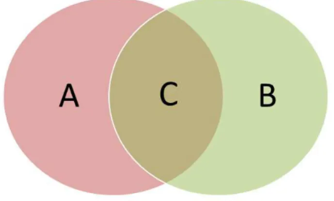
Due to the different scales used for source data and target data, the discrepancy in area calculation may easily arise. For example, CMA may use a higher resolution to reflect more details of burned areas at the regional level while EFFIS may use a lower resolution to reflect a larger extent of burned areas across Europe. To address this scale issue, we compare the two datasets quantitatively in terms of the number of burned areas, and the minimum and maximum size of burned areas respectively. Overlay analysis further enables common burned areas mapped by CMA and EFFIS to be calculated by GIS intersection operation. As illustrated in Figure 7, the two datasets are compared for total area mapped by CMA (A), total area mapped by EFFIS (B), common area mapped by both (C), and the difference area mapped by one another (A subtracted by C and B subtracted by C) [Boschetti et al 2008].
Figure 7. Venn diagram illustrating differences in burned areas mapped by CMA and EFFIS.
4.2 Schematic and Semantic Interoperability Testing
data model represents burned areas due to forest fires in Valencia Community. CMA holds this information in its regional SDI to keep track of geographical locations of land cover affected by forest fires every year [CMA 2007]. As shown in Table 4, burned areas are categorized into non-wooded forest surface and wooded forest surface.
Attribute Name Description in Spanish Description translated in English
NUMPARTE Código del parte Code of the report
MUNICIPIO Municipio Municipality
PROVINCIA Provincia Province
COMARCA Nombre de la comarca donde se
ubica el recinto
Name of the region where the compound is located
HOJA Hoja 1:50 000 Mapsheet 1:50 000
FECHA Fecha del incendio Date of the fire
TIPO_CAUSA Causa del incendio Cause of the fire
SUP_NARBOL Superficie no arbolada quemada en hectáreas
Non-wooded forest surface burned in hectare
SUP_ARBOLA Superfice arbolada quemada en hectáreas
Wooded forest surface burned in hectares
SUP_TOTAL Superficie quemada total en hectáreas
Total forest surface burned in hectares
Table 4. Source data model for burned areas mapped by CMA [Metadata: Incendios 200720].
The target data model by EFFIS represents burned areas damaged by fires in Europe. This information is publicly accessible via Map Viewer on the EFFIS website and is further used for post-fire assessments of atmospheric emissions and erosion risks [JRC 2009]. As shown in Table 5, burned areas are categorized based on land cover classification including non-forest cover types such as agricultural areas and artificial surfaces.
20
Attribute Name Description
ID Unique identification code
Country Country acronyms
CountryFul Full name of the country
Province Province of the commune
Commune Commune which include the largest burned area relative to the mapped fire
FireDate Starting date of the fire
Area_HA Total area (forest and non-forest) burned in hectares
BroadLea % of broad leaved forest burned
Conifer % of coniferous forest burned
Mixed % of mixed forest burned
Scleroph % of sclerophyllous vegetation burned
Transit % of transitional vegetation burned
OtherNatLC % of other natural areas burned and not related to the above mentioned classes
AgriAreas % of agricultural areas burned
ArtifSurf % of artificial surfaces burned
OtherLC % of other land cover burned (not related to the above mentioned classes)
LastUpdate Acquisition date of the most recent Modis image used to map the burned area
Table 5. Target data model for burned areas mapped by EFFIS [JRC 2009].
Based on the source and target data models presented in Tables 4 and 5, the following sections focus on the data attributes to perform schema mapping on the schematic and semantic levels. We first examine schematic matching based on names of attributes and then analyze semantic matching based on concepts of the attributes. Finally, semantically matching attributes are transformed by schema mapping operations.
4.2.1 Linguistic Matching Approach on the Schematic Level
Firstly, attribute names presented in Table 4 need to be translated from Spanish to English. When the translated source attribute can be directly matched to the target attribute, schema mapping is simple. Difference terms used in different languages can be translated by referring to a multi-language dictionaries or thesauri [Madhavan et al. 2001; Rahm and Bernstein 2001].
attributes with equal or similar names (Figure 8) [Rahm and Bernstein 2001]. Name-based matching can be defined in exploiting short-forms (Qty for Quantity), acronyms (UoM for UnitOfMeasure), synonyms (Car and Automobile), and hypernyms (Tree and Oak) [Madhavan et al. 2001; Rahm and Bernstein 2001]. With a good knowledge of source and target schemas, name matching can be mapped and illustrated by the Spatial ETL, FME.
Figure 8. Linguistic matching approach to schematic interoperability (Step 1).
4.2.2 Ontology-Based Matching Approach on the Semantic Level
When the term of a source attribute is translated to match with the target attribute, accuracy of linguistic matching can be assessed by defining entities of each attribute. Ontologies (Chapter 2.2) aid to ensure whether the direct language translation is sufficient for schema mapping.
Ontology-based mapping is one possibility to determine a shared concept between source and target attributes to achieve semantic interoperability. For this purpose, we first aim to establish application ontologies from source and target data models and then examine if establishment of the domain ontology can refine the shared concept between application ontologies [Klien and Probst 2005] to increase the level of semantic interoperability.
Conceptualization of entities can be visualized and described using software applications such as Protégé. Protégé represents ontologies that define classes, properties, property facets and constraints, instances, and the relationships between them [Knublauch et al. 2004]. We take a classification mapping approach with Protégé by establishing ontologies from schemas used in source and target
Name matching
Source Attribute
Target Attribute
data [Friis-Christensen et al. 2005]. We propose to establish two application ontologies based on data specifications defined by CMA and EFFIS. Currently, there are no official data specifications defined by CMA or EFFIS for burned areas. Since the majority of attributes contained in both data models are related to forest cover, data schemas for Forest Inventory in Valencia Community by CMA and CORINE Land Cover Classification by EFFIS are used as a guide to classification in Protégé. Studying how data attributes are specified in source and target schemas can describe classes, properties, and relationships. As shown in Figure 9, using a reasoner function (FaCT++) we reclassify source and target attributes to identify equivalent classes and similar classes [Friis-Christensen et al. 2005]. The reasoner based on description logic uses the descriptions of the classes to test if an equivalent or similar class relationship exists between them [Horridge 2009]. The reasoner can also help build the domain ontology shared by application ontologies by detecting inconsistencies, hidden dependencies, redundancies, and wrong classifications [Knublauch et al. 2004].
Figure 9. Ontology-based matching approach to semantic interoperability (Step 2).
4.2.3 Ontology-Based Schema Mapping
Following ontology-based attribute matching in Protégé, data transformations are performed by various schema mapping operations from source to target attribute (Figure 10). We apply the following schema mapping operations in the GML feature model suggested by Lehto [2007], in order to generate schema mapping rules at the levels of attributes and attribute values [HUMBOLDT 2009; Schade 2009]:
Source Attribute
Target Attribute
Semantically equal/similar classes
1. Filtering attributes,
2. Renaming attributes or their values,
3. Reclassification of attribute values by converging or diverging, 4. Merging / splitting attributes values,
5. Changing the order of attributes,
6. Value conversions: spatial generalization and unit conversion of attribute values,
7. Morphing spatial types and data types, and
8. Augmentation of attribute values by interpolation and default.
Figure 10. Ontology-based schema mapping rules for schema transformation (Step 3).
Source Attribute
Target Attribute
Ontology-based schema mapping rules Ontology-based matching +
5. RESULTS
This chapter presents the results of interoperability testing for geospatial data across regional, national and European administrative levels. Availability of forest cover data and burned area data is compared respectively to indicate the level of syntactic interoperability. For testing schematic and semantic interoperability, matching attributes of burned area data models between CMA and EFFIS and the associated mapping operations are presented. Discussions and recommendations follow in the next chapter.
5.1 Data Availability and Syntactic Interoperability
In this section we compared the current status of data availability for forest cover and burned areas among Valencia Community, Spain, and Europe. By testing syntactic interoperability, we achieved GIS overlay of commonly mapped burned areas between CMA and EFFIS and analyzed the consistency of such geospatial data qualitatively and quantitatively.
5.1.1 Forest Cover Data
SDI Level Regional National European
Area Valencia Community Spain Europe
Layer
Forest (Inventario Forestal de
la Comunidad Valenciana)
Forest (Mapa Forestal de
España)
Pan-European Forest/Non-Forest Map
Access OGC WMS OGC WMS OGC WMS
Format PNG, JPEG PNG, GIF, JPEG PNG, GIF, JPEG, TIFF
Metadata ISO 19115 ISO 19115 ISO19115
Year 2005 1997-2006 2000
Scale 1:10 000 1:50 000 1:5 000 000
Temporal
resolution Not regulated Every 10 years 1990, 2000, 2006
Spatial reference
system ED50 / UTM Zone 30N ED50 / UTM Zone 30N
ETRS89 /ETRS-LAEA Projection EPSG:4326 EPSG:23030 EPSG:4326 EPSG:23030 EPSG:3035 EPSG:4326
Language Spanish or Valencia Spanish English
Owner CMA MMA JRC
Table 6. Comparison of forest cover data between regional, national and European levels.
Advanced standard web services at regional, national, and European levels enable the data access to be interoperable within Europe. We can use a GIS software application as a common platform for adding forest cover data from CMA, IDEE, and EFDAC via OGC WMS. Forest cover data from these three sources can be added as layers in the software GUI and the GIS overlay of images from CMA and EFDAC is illustrated in Annex I. Legends of forest cover data are not shown via WMS, however, they can be viewed in Map Viewer on each web portal of CMA, IDEE, and EFDAC. CMA displays forest and non-forest areas in polygon while EFDAC displays forest and non-forest areas in raster. The GIS overlay made it apparent that scales and languages are significantly different even for the most fundamental forest data.
5.1.2 Forest Fire Data
spatial resolution is low when one attempts to focus on a region such as Valencia Community. The minimum fire size mapped is coarse due to the low spatial resolution. In the regional SDI provided by CMA, the forest fire theme in general is not freely accessible to the public. Moreover, the up-to-date information is not available on the Intranet since burned areas from the last summer 2009 are not inputted into the SDI yet. However, it must be noted that the quality of spatial resolution is much higher than the burned area data provided by EFFIS, which is why fires as small as 0.05 hectare can be detected.
SDI Level Regional National European
Area Valencia Community Spain Europe
Layer Forest Fires (incendios) Burned Area
Access ArcIMS (internal) Map Viewer
Format PNG, (Shape upon
request)
OWS, (Shape upon request)
Metadata ISO 19115 ISO 19115
Year 1993-2007 1987-2009
Spatial resolution 20 m 250 m
Minimum fire size 0.05 ha 50 ha
Temporal
resolution annually annually
Spatial reference
system ED50 / UTM Zone 30N
ETRS89 /ETRS-LAEA
Projection EPSG:23030 EPSG:3035
Language Spanish or Valencia English
Owner CMA JRC
Table 7. Comparison of forest fire data between regional and European levels.
5.1.3 Burned Area Calculations
Figure 11. GIS overlay image of burned areas in Valencia Community mapped by CMA (solid polygons) and EFFIS (solid lines) at scale 1:20 000.
CMA EFFIS
Number of Fires 372 3
Minimum Size (ha) 0.05 89.01
Maximum Size (ha) 5860.00 8125.56
Total Area (ha) 8524.88 8315.20
Table 8. A summary of burned areas in Valencia Community mapped by CMA and EFFIS.
In addition, GIS overlay analysis of the two data layers enabled us to calculate the intersected area as a common burned area mapped by both CMA and EFFIS (Table 9). The commonly mapped burned area was 5565 hectares, which accounts for 67% of the total area mapped by CMA and 65% of the total area mapped by EFFIS. In other words, 33% of the total area mapped by CMA was not detected as burned by EFFIS, and 35% of the area total area mapped by EFFIS was not considered as burned by CMA. These discrepancies were caused by scales, spatial resolutions, and mapping schemas.
Total area mapped by
CMA
Total area mapped by EFFIS
Common area mapped by CMA
and EFFIS
Area mapped as burned by CMA but not by EFFIS
Area mapped as burned by EFFIS but not by CMA
8525 8315 5565 2960 2750
67% 65% 33% 35%
Table 9. Quantitative overlay analysis of burned areas in hectares mapped by CMA and EFFIS.
5.2 Ontology-Based Schema Mapping
This section shows outcomes of testing interoperability on the schematic and semantic level. Matching attributes are presented following name-matching approach and ontology-based matching approach. In addition, schema mapping operations are identified corresponding to matching attributes.
5.2.1 Name Matching Attributes
target attributes in the FME, as illustrated in Figure 12. There are four matching attributes from to target data models:
NUMPARTE → ID PROVINCIA → Province
MUNICIPIO → Commune FECHA → FireDate
SUP_TOTAL → Shape_HA
Figure 12. Name matching attributes from source to target data using the FME.
5.2.2 Ontology-Based Matching Attributes
NUMPARTE = ID PROVINCIA = Province MUNICIPIO = Commune FECHA = FireDate
SUP_TOTAL ≠ Shape_HA →SUP_TOTAL ≈ superclassOf(Shape_HA)
Figure 13. Equivalent and similar classes inferred by reasoner in Protégé for name-matching attributes.
‘NUMPARTE’ and ‘ID’ were inferred as equivalent classes as they both have an object identifier in number. ‘PROVINCIA’ and ‘Province were also interfered as equivalent according to the administrative level specified by European Union (i.e. NUTS21 Level Code 3). In the same manner, ‘MUNICIPIO’ and ‘Commune’ that belong to NUTS Level Code 5 were inferred as equivalent. ‘FECHA’ and ‘FireDate’
were confirmed as equivalent classes as they both have the date of a fire event. On the other hand, the reasoner did not infer ‘SUP_TOTAL’ and ‘Shape_HA’ as equivalent classes. This is because ‘SUP_TOTAL’ is defined by the total forest area burned while ‘Shape_HA’ is identified by the total land area (forest and non-forest)
21
burned. Nevertheless, both attributes share the common class description of having the forest area burned, which resulted in that ‘SUP_TOTAL’ is superclass of ‘Shape_HA’.
Some source attributes are not matched to the target attributes on the schematic level for two reasons. One is that the matching attributes simply do not exist. In such case, those source attributes may be lost after schema mapping [HUMBOLDT 2009]. For example, ‘TIPO_CAUSA’ in source data does not have any matching candidates related to the type of cause in target data. Another reason is that some source attributes have matching candidates but the definitions of attributes used in source and target data models are not known. Examples of those source attributes in our use case are related to forest cover types.
The application ontology based on the source data model is based on forest cover classification in Valencia Community defined by CMA while the application ontology based on the target data model follows CORINE land cover classification defined by EEA. Criteria to define forest classes include tree type, tree height, and canopy cover closure. Using the reasoner in Protégé, equivalent and similar classes can be reclassified. There are no equivalent classes found by ontology reasoning due to the complexity of forest type definitions in both source and target classifications. However, the following similar classes are inferred in the same manner as shown in Figure 14:
SUP_NARBOL ≈ subclassOf (Transit)
![Figure 2. Components for spatial data integration over the Web [Diaz et al. 2009].](https://thumb-eu.123doks.com/thumbv2/123dok_br/15755617.638805/19.893.230.674.128.527/figure-components-spatial-data-integration-web-diaz-et.webp)
![Figure 5. Harmonized assessment in a nested forest information system [JRC 2007].](https://thumb-eu.123doks.com/thumbv2/123dok_br/15755617.638805/27.893.339.582.775.1049/figure-harmonized-assessment-nested-forest-information-jrc.webp)
![Table 1. Spatial data available for forest cover and fires in Europe [EuroGEOSS 2009]](https://thumb-eu.123doks.com/thumbv2/123dok_br/15755617.638805/29.893.150.763.128.878/table-spatial-available-forest-cover-fires-europe-eurogeoss.webp)
![Table 2. Spatial data available for forest cover and fires in Spain [EuroGEOSS 2009].](https://thumb-eu.123doks.com/thumbv2/123dok_br/15755617.638805/30.893.150.766.275.627/table-spatial-available-forest-cover-fires-spain-eurogeoss.webp)
![Table 3. Spatial data available for forest cover and fires in Valencia Community [EuroGEOSS 2009]](https://thumb-eu.123doks.com/thumbv2/123dok_br/15755617.638805/31.893.145.771.639.947/table-spatial-available-forest-cover-valencia-community-eurogeoss.webp)