Franca do Campo (Azores Archipelago, Portugal)
V. N. Martins1, P. Cabral2, and D. Sousa e Silva31Centro de Estudos Sociais da Universidade dos Ac¸ores, Ponta Delgada, Portugal
2Instituto Superior de Estat´ıstica e Gest˜ao de Informac¸˜ao, Universidade Nova de Lisboa, Lisboa, Portugal 3N´ucleo de Ecologia Social do Laborat´orio Nacional de Engenharia Civil, Lisboa, Portugal
Correspondence to: V. N. Martins (vmartins@uac.pt)
Received: 16 June 2011 – Revised: 22 June 2012 – Accepted: 7 July 2012 – Published: 3 September 2012
Abstract. Seismic risk mitigation comprises of land-use planning policies that enable risk reduction in areas exposed to earthquakes. Thus, the assessment of land-use plans re-garding urban growth in seismic prone areas is very impor-tant. This article analyses the urban expansion of Vila Franca do Campo (island of S. Miguel, Azores, Portugal) from 1994 to 2005 based on ortophotomaps interpretations and simu-lates a scenario of urban growth for the year 2016 with a Land-use and Cover-Change (LUCC) model (Geomod). The goal is to evaluate the potential impact of land-use plans in managing urban growth and promoting seismic risk mitiga-tion. Results indicate that the urban expansion, between 1994 and 2005, was done according to the Municipal Master Plan (MMP) restrictions. The scenario modelled for the year 2016 is potentially stricter for urban growth because it adds to the previous plan the constraints defined by the South Coast Management Plan (SCMP) that entered into force in 2007. In both time periods, a continuing urban growth towards seis-mic areas was identified. The absence of seisseis-mic risk mitiga-tion policies and measures on both plans may contribute to increase the seismic hazard exposure and vulnerability. The results of this study strongly suggest the reformulation of fu-ture land-use plans to include seismic risk mitigation goals and policies.
1 Introduction: the theory and the aim
Earthquakes are massive, sudden and quite unpredictable geophysical phenomena. Their location, frequency and mag-nitude may interfere negatively with the regular behaviour of the social, economical and political environments of
the communities, societies or even countries (Oliver-Smith, 2004). The severity of disasters triggered by seismic events is the outcome of the interaction between the geophysical phenomenon and the societies, namely, their built environ-ment characteristics (Hewitt, 1997). During the 20th cen-tury, the population growth stimulated the construction of settlements in risk areas which often adopted inadequate con-structive solutions towards seismic risk, thus, contributing for an increase of the number (CRED, 2010) and severity of earthquake-triggered disasters.
Nevertheless, societies have the ability to adjust to seismic risk by adopting formal responses to the disasters (Birkmann et al., 2010), mainly found in risk mitigation policies. Risk mitigation is a coordinated strategy, based on goals, poli-cies and measures to minimise human and material losses from natural hazards and resulting disasters, normally being planned long term (Godschalck and Brower, 1985; Dynes, 1991). The mitigation of seismic risk is normally focused on land-use planning since it is the most effective tool to im-plement mitigation policies (Berke and Beatley, 1992; God-schalck et al., 1998). According to UN/ISDR (2004), land-use planning allows the combination of urban areas manage-ment and their need for social, economic and environmanage-mental development, while ensuring the reduction of risk for indi-viduals and communities.
Godschalck et al. (1998) identify the benefits of incorpo-rating risk mitigation with land-use planning. These include: (i) raising the awareness in communities regarding exposure to natural hazards and their potential consequences; (ii) iden-tifying the relationships and the conflicts between public in-terest and the proposed mitigation policies; and (iii) building
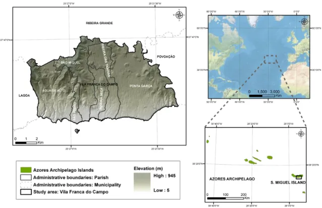
Fig. 1. The study area.
consensus among those responsible for proposing and imple-menting mitigation measures.
The mitigation of seismic risk through land-use planning is a multi-stage process (Berke and Beatley, 1992). Initially, it is necessary to define the extent of the problem concerning the need to introduce risk mitigation, while the second stage comprises the formulation of objectives and policies. In the third stage, planning measures are defined, according to the goals and policies outlined on the previous stage. The pro-cess is concluded with the implementation, monitoring and revision of plans that support the policies.
The success of land-use planning in seismic risk reduction depends on the type of plan being developed. Comprehensive plans are best suited to include mitigation policies, because “that plan normally already has a standing in the community as a policy guide, and the comprehensive plan encourages integration of mitigation goals and programmes with other ongoing community goals and programmes” (Godschalck et al., 1998, p. 101). Comprehensive plans comprise mitiga-tion measures with regulatory nature, namely: building codes (e.g., Eurocode 8); zoning provision (e.g., peak ground accel-eration; faults lines); regulation of urban density; and urban clustering development (Berke and Beatley, 1992). Since the land-use plans are the result and the support of the planning process, being a key step towards seismic mitigation imple-mentation, the assessment of their impact in the urban growth on seismic areas is utterly relevant.
The adoption of the theoretical principles of Land-Use and Cover-Change models in seismically active areas is useful for three main reasons. First, it allows the analysis of LUCC by identifying the mechanisms that trigger land-use transitions and the driving forces supporting them, and also their im-pacts (Verburg et al., 1999). For instances, it is possible to verify if the former and/or current land-use planning poli-cies foster sustainable urban growth by establishing an eval-uation comparison between the observed land-use allocation with the restrictive regulations (Koomen et al., 2008). Sec-ond, LUCC models allow the assessing of the potential im-pact of land-use plans in urban growth (He et al., 2008). They make possible the identification of mitigating measures and actions within the plans, to know their regulatory or nonreg-ulatory nature, and to measure the extent of their implemen-tation. Third, LUCC models may support the development of future land-use plans (Verburg et al., 1999) by suggesting the incorporation of seismic risk mitigation policies.
This article aims to raise the awareness of the need to include seismic hazard mitigation policies and measures in land-use plans in earthquake prone areas. Two objectives are pursued: (i) to assess the impact of the Municipal Master Plan on urbanisation and seismic risk reduction in the municipal-ity of Vila Franca do Campo between 1994–2005 using or-tophotomaps interpretations; and (ii) to model urban growth for the year 2016, which also includes the South Coast Man-agement Plan, to verify the possible outcomes of land-use policies.
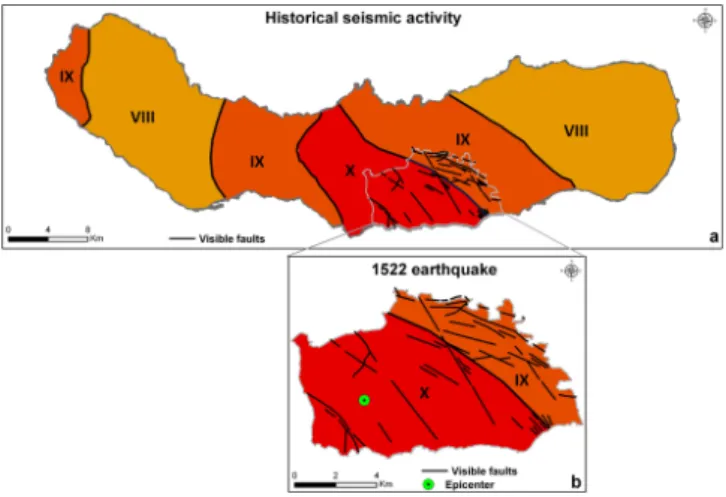
Fig. 2. Isoseismal maps representing the historical seismic activity
in S. Miguel Island and Vila Franca do Campo (EMS-98). Adapted from Silveira et al. (2003). (a) illustrates the maximum historical intensity isoseismal map of S. Miguel Island (EMS-98). (b) repre-sents the isoseismal map (EMS-98) of the 1522 earthquake and the epicentre.
2 Study area
The Azores archipelago is located in the North Atlantic Ocean, in the Macaronesian biogeographical region, at about 1450 km from mainland Portugal (Fig. 1). The archipelago is composed of nine islands of volcanic genesis, along-side a NW–SE orientation, and is divided in three groups: Eastern group (Santa Maria and S. Miguel islands); Cen-tral group (Terceira, Graciosa, S. Jorge, Pico and Faial is-lands); and Western group (Corvo and Flores islands). The municipality of Vila Franca do Campo, with 78 km2, is lo-cated on the southern coast of the island of S. Miguel, be-tween parallels 37◦420–37◦470N latitude and the meridian 25◦200– 25◦290W longitude (Fig. 1). It is divided into the parishes of ´Agua de Alto, Ponta Garc¸a, Ribeira das Ta´ınhas, S. Miguel, S. Pedro and Ribeira Seca. According to the Cen-sus 2001 (SREA, 2001), the municipality had 11 150 inhabi-tants and a population density of 143 inh./km2. The parishes of S. Miguel and Ponta Garc¸a are the most populated and the ones with a more consolidated urban area, contrasting with other parishes where linear and dispersed patterns of human occupation are predominant.
The cohabitation of Azorean population with the seismic threat dates back to the colonization during the 15th century. The location of the Azores Archipelago in the triple junc-tion of American, Eurasian and African litospheric plates, and the presence of three main tectonic structures in the re-gion: the Mid-Atlantic Ridge, the East Azores Fracture Zone and the Terceira Rift (Valad˜ao et al., 2002), increases the exposure of the archipelago to the seismovolcanic episodes. Vila Franca do Campo is located on a seismogenic region dominated by the presence of regional tectonic structures with a NW–SE, NE–SW, WNW–ESSE and E–W orientation
Fig. 3. Urban expansion restriction plans of MMP and SCMP.
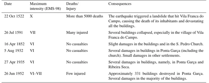
(Gomes et al., 2005). In the map of the historical seismic activity of S. Miguel Island, the municipality is within the area limited by the IX/X-grades maximum intensity iso-seismal (Fig. 2a) of the European Macroseismic Scale-1998 (EMS-98) (Silveira et al., 2003). One of the most destructive earthquakes which occurred in Azores was on the 22 Octo-ber 1522, nefariously hitting Vila Franca do Campo (Fig. 2b). This earthquake triggered a landslide which caused 5000 ca-sualties and the destruction of the settlers’ houses. Since then the municipality suffered five more disastrous episodes as a consequence of the earthquakes (Table 1).
3 Land-use planning at the local scale
The municipality of Vila Franca do Campo is regulated by two land-use plans: the MMP and the SCMP of S. Miguel Is-land. The MMP was approved by the 184/1997 resolution from 02/10, and it was later changed by the declarations 32/1997 from 06/11, and 4/1998 from 23/03. Article 4 of the MMP considers three restrictive elements of urbanisa-tion in the municipality: (i) Constrained Areas; (ii) Regional
Table 1. Earthquakes occurred in the Azores Archipelago which caused human and material losses in Vila Franca do Campo (CMVFC,
1999; Silveira et al., 2003).
Date Maximum Deaths/ Consequences intensity (EMS-98) Injury
22 Oct 1522 X More than 5000 deaths The earthquake triggered a landslide that hit Vila Franca do Campo, causing the death of its inhabitants and devastating all the buildings.
26 Jul 1591 VII Many injured Several buildings collapsed, especially in the village of Vila Franca do Campo.
16 Apr 1852 VI No casualties Slight damages in the buildings and in the S. Pedro Church. 5 Aug 1932 VI No casualties Several damages in buildings in Ponta Garc¸a (including the
church). Small damages in other settlements.
27 Apr 1935 VI No casualties Several damages in buildings, namely, in Ponta Garc¸a and Ribeira Seca.
26 Jun 1952 VI–VII Few injured Approximately 331 buildings destroyed in Ponta Garc¸a. Several damages in the majority of the buildings.
Agricultural Reserve (RAR) and (iii) Regional Ecological Reserve (RER) (Fig. 3a). Concerning seismic mitigation, two regulatory articles were identified within the MMP: (i) Arti-cle 8, disallowing the construction of public buildings in ar-eas of geological faults; and (ii) Article 24, preventing urban-isation inside geological fault zones (CMVFC, 1997). Nev-ertheless, these areas are not mapped in the MMP restriction plans. We must notice the lack of seismic mitigation regula-tion in the MMP and the absence of seismic hazard zonaregula-tion within the plan, i.e., local peak ground acceleration maps.
The SCMP was approved by the 29/2007 resolution from 5/12 and covers the 14 km coastline. It contains a shoreline protection area with a maximum width of 500 m from the coastline and a full marine protection area defined by the
−30 m isobaths. Article 5 of the SCMP defines four urban expansion restrictions in the area: (i) Maritime Public Do-main; (ii) reserve areas of soil, fauna and flora; (iii) RAR and (iv) RER (Fig. 3b). To minimise natural risk situations, the SCMP presents a multi-hazard approach to regulate urban growth which includes a hazard zoning where “Built Envi-ronment in Areas at Risk” are identified (Fig. 3b). Articles 32 and 33 define the multi-hazard mitigatory measures to adopt in these areas, namely: urban growth restrictions, relocation and buildings rehabilitation (DROTRH/SRAM, 2007).
4 Data and methods 4.1 Modelling approach
The LUCC model was developed using IDRISI Andes soft-ware in three stages: (i) mapping of the urban areas of years 1994 and 2005 based on ortophotomaps interpretation; (ii) suitability map assessment for urban areas using Multi-criteria Analysis (MCA) techniques; and, (iii) validation and
simulation of an urban growth scenario for the year 2016 using Geomod. The initial stage aims to analyse the land-use allocation in the period 1994–2005 and land-use the resulting land-use maps as input for the simulation model. The second stage presents a heuristic suitability assessment which incor-porates expert knowledge in the modelling approach, avoid-ing a stochastic model based on conditional probabilities that would worsen the results (Cabral, 2006). The last stage com-prises urban growth modelling and validation procedures for creating an urban growth scenario for 2016 using the results from the previous stages. The different stages rationale is ex-plained in the following subsections.
4.2 Mapping urban areas of years 1994 and 2005 The land-use maps were produced based on visual inter-pretation of ortophotomaps of years 1994 and 2005 (0.5 m pixel resolution; 1 : 5000 scale) (SRCTE, 2010). The adopted nomenclature was the 1st level of Corine Land Cover pro-gramme which considers five categories of land-use: (i) artifi-cial areas; (ii) agricultural areas; (iii) forest and semi-natural areas; (iv) wetlands; (v) water bodies (EEA, 2000). For both maps, a 2 hectare Minimum Mapping Unit (MMU) was de-fined with a 1 : 5000 work reference scale.
Thematic generalisation operations were carried out in which the areas with a MMU lower than 2 hectares were aggregated to the neighbouring land-use categories with a MMU greater or equal than 2 hectares. The land-use maps were converted from vector to raster data using a 10 m reso-lution. Figure 4 reveals an increase of the territory occupied by artificial areas between 1994 and 2005 due to urbanisation towards the agricultural areas.
Finally, a reclassification operation was carried out in which the urban class corresponded to the artificial areas and the non-urban class resulted from the aggregation of
Fig. 4. Pixel sums of the Corine Land Cover classes for 1994 and
2005.
agricultural areas, forest and semi-natural areas, wetlands and water bodies. Two binary maps for 1994 and 2005 were produced (Fig. 5).
4.3 Suitability map for urban areas
This map defines the suitability of a cell changing from non-urban to urban class based on driving forces and ex-clusionary factors which can be obtained using MCA tech-niques (Voogd, 1983). In this case, a suitability map was created to incorporate expert knowledge based on a multi-stage group decision-making approach involving the authors of this study. This process was carried out in four stages and the result was used as an input of the model.
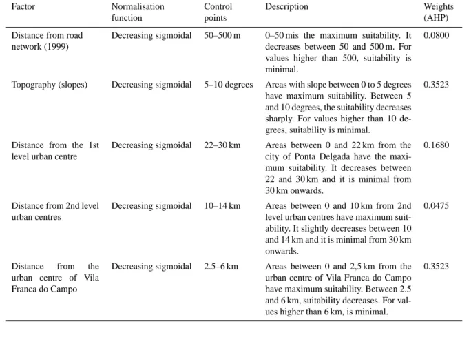
In the first stage, factors and constraints were identified. The driving forces incorporated in LUCC models are fre-quently related to socioeconomic and biophysical factors (Henr´ıquez et al., 2006). Based on the potential behaviour of the local population towards land-use development, five factors were selected: (i) distance from roads (regional and municipal roads); (ii) topography (slope); (iii) distance from the 1st level urban centre (Ponta Delgada city); (iv) distance from 2nd level urban centres (Ribeira Grande and Lagoa vil-lages); and (v) distance from the urban centre of Vila Franca do Campo (IGEOE, 1999). Two constraints restricted urban growth: (i) MMP and SCMP maps (Fig. 3); and (ii) the built areas of 1994, since urban growth cannot occur into previ-ously built areas. We stress that the selection of factors and constraints reflects the basic constraints used for urbanisa-tion in general and ignore the mitigaurbanisa-tion of geo-hazards.
The second stage comprised the factors standardisation. The integration and comparison of suitability factors is con-ditioned by the different measuring scales, making it imper-ative to standardise them on a common scale (Rashed and Weeks, 2003). Fuzzy Set Membership was employed to stan-dardise the factors (Malczewski, 1999). It expresses the “rel-ative degree of belonging to a set, ranging from 0.0 to 1.0, indicating a continuous growth from not belonging up to to-tal belonging” (Hansen, 2005, p. 78). Table 2 summarises the standardisation procedure.
Fig. 5. Land-use maps of Vila Franca do Campo in 1994 and 2005.
During the third stage, the estimation of the factors weighting was carried out using the Analytical Hierarchy Process (AHP) method (Saaty, 1980). AHP is based on a comparison matrix to evaluate criteria according to the rel-ative importance of the pairwise of factors being estimated (Eastman, 2006). The relative importance of each factor was defined based on the authors’ knowledge about the study area regarding the demographic, socioeconomic and cul-tural dimensions (Martins et al., 2012). Results (Table 2) show that topography and distance from the urban centre of Vila Franca do Campo have the highest suitability weights (0.3523), followed by the distance from the 1st level urban centre (0.1680). Distance from road networks (0.0800) and distance from 2nd level urban centres (0.0475) are the less important factors for suitability assessment. The consistency ratio which measures the consistency of the pairwise com-parisons was 0.05 indicating a reasonable consistency level (Malczewski, 1999).
Decision rules is the final stage of the process, in which the suitability criterions are aggregated using Weighted Lin-ear Combination (WLC). This method aggregates the factors by means of a weighted average (Eastman, 2006) which con-siders the criteria weights determined in the previous stage. According to Hansen (2005), the WLC Eq. (1) considers the suitability Sk at the k-th pixel:
Sk=Xwixik (1)
where wi is the weight and xik is the value of criterion i in
the k-th pixel (Hansen, 2005). The suitability is represented through a continuous scale of values, where 0 express the low suitability while 255 is assigned to high suitability values (Fig. 6).
4.4 Urban modelling for year 2016 with Geomod Geomod (Pontius et al., 2001) is a LUCC model imple-mented by several authors to simulate land-use changes and
Table 2. Standardisation procedures of the land-use change (non-urban to urban) driving factors and factors weights resulting from AHP.
Factor Normalisation Control Description Weights
function points (AHP)
Distance from road network (1999)
Decreasing sigmoidal 50–500 m 0–50 mis the maximum suitability. It decreases between 50 and 500 m. For values higher than 500, suitability is minimal.
0.0800
Topography (slopes) Decreasing sigmoidal 5–10 degrees Areas with slope between 0 to 5 degrees have maximum suitability. Between 5 and 10 degrees, the suitability decreases sharply. For values higher than 10 de-grees, suitability is minimal.
0.3523
Distance from the 1st level urban centre
Decreasing sigmoidal 22–30 km Areas between 0 and 22 km from the city of Ponta Delgada have the maxi-mum suitability. It decreases between 22 and 30 km and it is minimal from 30 km onwards.
0.1680
Distance from 2nd level urban centres
Decreasing sigmoidal 10–14 km Areas between 0 and 10 km from 2nd level urban centres have maximum suit-ability. It slightly decreases between 10 and 14 km and it is minimal from 30 km onwards.
0.0475
Distance from the urban centre of Vila Franca do Campo
Decreasing sigmoidal 2.5–6 km Areas between 0 and 2,5 km from the urban centre of Vila Franca do Campo have maximum suitability. Between 2.5 and 6 km, suitability decreases. For val-ues higher than 6 km, is minimal.
0.3523
Fig. 6. Urban areas suitability map.
predict the expansion of urban areas (Pinto et al., 2009; Chen and Pontius, 2010). Geomod was the selected model to sim-ulate urban growth between two categories (non-urban to urban) considering the MMP and SCMP regulations. Addi-tionally, Geomod does not require a large amount of data to run which was a decisive feature due to the impossibility of
mapping land-use in more than two time moments (1994 and 2005).
The modelling of Vila Franca do Campo urban expansion considers the 1994 land-use image as reference time 1, the 2005 year as the reference time 2, while the year 2016 (an equivalent time period to the one between 1994 and 2005) corresponds to simulated time 3. The suitability map was used to locate the cells changing their state according to the transition rules, while a neighbourhood constraint search of 5 × 5 cells was employed for an 11 yr time step. Geomod re-stricts the change of land-use state to cells that are on the edge between two categories of land-use assuming that the development of new areas can only succeed in previously de-veloped areas.
After the previous stage of calibration, the assessment of the predictive power of LUCC models is developed through the verification of the “goodness-of-fit” of validation (Pon-tius et al., 2004; Pon(Pon-tius and Malanson, 2005). The validation of LUCC models predictive scenarios require a three-map comparison where the maps are reference time 1, reference time 2, and simulation time 2. Validation comprehends the agreement (or error) resulting from the comparison between the simulation time 2 map and the reference (or real) time 2 map. In this case, quantity disagreement and allocation dis-agreement (Pontius and Millones, 2011) were the measures
Fig. 7. Prediction correctness and error based on 1994 (reference), 2005 (reference) and 2005 (simulated) land-use maps.
used for assessing the accuracy of the model. The number of urban cells of the reference image of 2005 was used for modelling urban growth for year 2005, thus, there is not any disagreement due to quantity when comparing the model re-sult for 2005 with the reference image of 2005.
Figure 7 shows the comparison of the observed change with the predicted change and distinguishes four types of correctness and error (Chen and Pontius, 2010): Correct due to Observed Persistence Predicted as Persistence (null successes), Error due to Observed Persistence Predicted as Change (false alarms), Correct due to Observed Change dicted as Change (hits), Error due to Observed Change Pre-dicted as Persistence (misses). This map was created using the predicted land cover map of 2005 which was overlaid with the reference map of 1994 to reflect persistence versus change. The percent of landscape that is hits correspond to 0.33 % while the false alarms correspond to 0.83 %. There is only allocation error because we used the correct quantity (2.5 %). The total error (2.5 %) is greater than the observed change (1.7 %) so this model is less accurate than its null model, i.e., a model of no change.
The “figure of merit” is a ratio where the numerator is the number of hits and the denominator is the sum of hits, misses and false alarms. It ranges from 0 %, meaning no overlap between observed and predicted change, to 100 %, mean-ing perfect overlap between observed and predicted change (Pontius et al., 2011). In this case, the figure of merit was 17 % which is a low performance, although higher than in some of the case studies presented in Pontius et al. (2008). The reasons for this performance may be explained by the small urbanised area between 1994 and 2005 (1.7 % of the total study area) and also by not having considered all the
factors responsible for urban growth in the modelling pro-cess.
Finally, an urban growth scenario was modelled for the year 2016. This scenario assumes that urban growth tendency is the same as the one that was verified between 1994 and 2005, so the suitability map used was the same suitability map employed for modelling year 2005. The cells that are likely to change their state from non-urban to urban for year 2016 were obtained by linear extrapolation.
5 Results
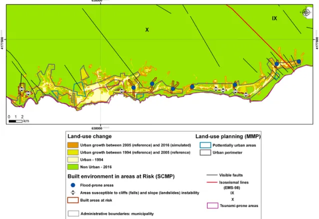
In 1994, the urban areas represented 149.6 hectares of the territory while, in 2005, this value was 285 hectares. Dur-ing 1994–2005, there was a significant urban growth in the surrounding areas of previously urbanised areas (Fig. 8). Ur-ban growth occurred mainly in the areas defined as “ur-ban perimeters” or “potentially ur“ur-ban areas” by the MMP (Fig. 9): 118.8 hectares (87.7 %) of the total of 135.4 hectares of urban growth (in the period 1994–2005) occurred within these areas, while the remaining 16.6 hectares (12.3 %) oc-curred outside (Fig. 8). On the other hand, regarding the ur-ban expansion occurred outside the “urur-ban perimeters” and “potentially urban areas” (Fig. 9), only 4.5 hectares (37.1 %) were located in areas where the urban growth is strictly re-stricted, while 12.1 hectares (62.9 %) were located in non-restricted areas (Fig. 8). Although urban growth is residual inside the areas mapped as restricted by the MMP regula-tory plans, it occurred in areas protected by RER regulations (Fig. 3a) which aim to protect natural resources and to avoid the urbanisation of hazardous places. Urban expansion has progressed towards the interior of the municipality and not
Fig. 8. Land-use change in Vila Franca do Campo, considering land-use plans and natural hazardousness. The figure shows the land-use use
change in the period between 1994 and 2016, the land-use planning zonation elements, the areas built in hazardous areas and the seismic hazard elements.
along the coastline due to restrictions of the MMP, which define a buffer zone around the cliffs (Fig. 3a). We can es-tablish, based on the previous remarks, that MMP regulatory plans (Fig. 3a) had a restraining effect on urban growth be-tween 1994 and 2005 despite the slight urban growth inside the restricted areas defined by the MMP (4.5 hectares). This shows that the regulations of MMP (non mitigatory) were implemented.
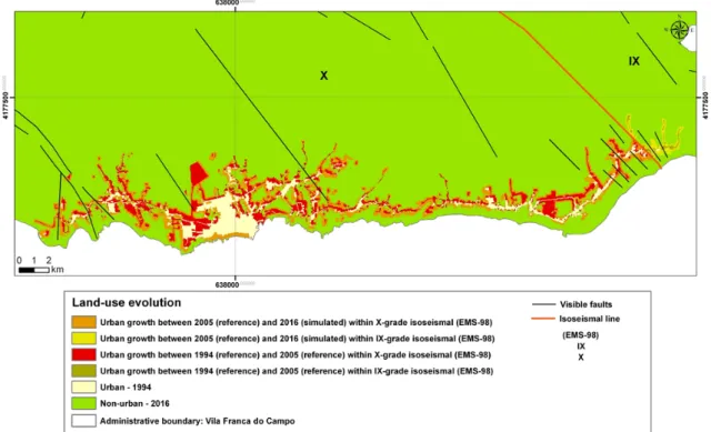
Nevertheless, considering the elements that characterise seismic hazard in Vila Franca do Campo – geological faults and the isoseismal map (CMVFC, 1999) – it is possible to set some considerations regarding the success of MMP in mitigating seismic risk. In the 1994–2005 period, the urban expansion corresponded to a total area of 135.4 hectares, where 124 hectares (91.6 %) were located in the area limited by the X-grade isoseismal on EMS-98, while the remaining 11.4 hectares (8.4 %) were inside the area enclosed by the IX-grade isoseismal (Fig. 10). Between 1994 and 2005, ur-ban growth occurred in areas with geological faults inside the urban perimeter (8 hectares), mainly in ´Agua de Alto, Ponta Garc¸a and to the N of the parish of S. Pedro (Fig. 10). This shows that the lack of hazard zoning (e.g., peak ground accel-eration; fault lines; historical seismic activity maps) prevents the effectiveness of the 24th article of the MMP. In Fig. 8, it
Fig. 9. Urban growth in the study area between 1994 and 2005
(hectares) considering the MMP jurisdiction areas.
is possible to identify vulnerable areas to tsunamis (CMVFC, 1999) where the areas of greatest exposure correspond to the main urban centres of the parishes of S. Miguel and S. Pedro (16 hectares).
In the period between 2005 (reference) and the scenario for 2016 (Fig. 8), the urban areas are predicted to repre-sent 420 hectares. In this case, as verified in the period
Fig. 10. Land-use change within the study area, taking into account the seismic hazard zonation, namely, isoseismal lines (EMS-98) and
visible faults.
1994–2005, the development of new urban areas may oc-cur within the “urban perimeters” and “potentially urban ar-eas” of the MMP. It must be noted that these areas have the highest suitability values (Fig. 6). The scenario for 2016 sug-gests that the restrictive plans of MMP, and also the SCMP restrictions, will restrain urban growth (Fig. 3b). Neverthe-less, the predictive scenario appears to confirm a continuous urban growth in the areas mainly classified as X-grade by the EMS-98 and also in the areas with geological faults (Fig. 10). It should be stressed that the areas classified by the SCMP as “Built Environment in Areas at Risk”, where the flood-prone and cliff/slope instability areas are located, showed no urban growth for 2016 because they were used as a constraint in the model (Fig. 8). These areas had a minor urban growth between 1994 and 2005, when the SCMP was not in force.
6 Conclusions
This study draws important conclusions about the regulatory action of the land-use plans in Vila Franca do Campo regard-ing the urban development and their (in)efficiency in control-ling this phenomenon according to seismic risk exposure.
Regarding the general restrictions (non mitigatory) of the MMP, the urban expansion was done according to the plan-ning and development strategy outlined by the municipality during the period 1994–2005. Since the MMP was imple-mented and met with the general planning goals and urban development constraints, we conclude that it had a positive
action in controlling urbanisation according to the estab-lished restrictive zoning regulations. The predicted scenario for 2016 reinforces this conclusion. On the other hand, con-sidering the effect of mitigatory restrictions of the MMP (e.g., article 24) on urban growth, the MMP failed to promote the seismic risk reduction since it has occurred towards seis-mic prone areas in the period 1994–2005. Thus, the above positive seeming effects of the MMP are not comprehen-sive, since it does not couple land-use planning with seismic risk mitigation. We conclude that the planning process and land-use plan (MMP) were not structured towards seismic risk mitigation. These findings support the conclusions of the works from Calado et al. (2011) where it is stated that un-derstanding the unique characteristics (e.g., population den-sity; socioeconomic activities; natural hazardousness) of the Azores small islands is critical to establish the most appro-priate land-use management policies, measures and actions.
Vila Franca do Campo is the municipality with the largest number of casualties due to earthquakes in the Azores Archipelago with a long record of earthquake-triggered disasters. Accordingly, the land-use planning process (and plans) must be more comprehensive towards seismic risk re-duction (Martins et al., 2012). Thus, the construction of dis-aster resilient communities must be based in hazard mitiga-tion and land-use planning, since it is the most capable ally to introduce mitigatory goals, policies and measures (God-schalck et al., 1998). This process must be supported by haz-ard zonation (Berke and Beatley, 1992).
Geomod provided relevant spatio-temporal information about the urbanisation process and the possibility to under-stand the influence, effectiveness and efficiency of land-use plans on urban dynamics and seismic risk exposure. The low performance of the model, as indicated by the figure of merit (17 %), calls for future experimentations using other fac-tors/constraints and/or modelling approaches. The scenario for 2016 is, as in any future scenario (Pontius et al., 2008), to be interpreted with caution.
Despite these limitations, the results are relevant for rais-ing the awareness of policy makers, public officials and advo-cates of the need to include seismic risk mitigation policies in land-use plans. Establishing the relationship between urban expansion and seismic risk also allows measuring the poten-tial impact of future disasters triggered by earthquakes. This can also be useful to support emergency management oper-ational strategies. Future research will extend this methodol-ogy to all the Azores Archipelago.
Acknowledgements. The authors would like to thank the
Luso-American Foundation (FLAD), which funded the project “Risk
Governance: the case of seismic risk in Azores”. We would also
like to thank the reviewers for their useful comments that helped us improving this paper.
Edited by: A. G¨unther
Reviewed by: E. Koomen, R. G. Pontius, and one anonymous referee
References
Berke, R. P. and Beatley, T.: Planning for earthquakes: risk, poli-tics, and policy, The Johns Hopkins University Press, Baltimore, 1992.
Birkmann, J., Buckle, P., Jarger, J., Pelling, M., Setiadi, N., Garschagen, M., Fernando, F., and Kropp, J.: Extreme events and disasters: a window of opportunity for change? Analysis of orga-nizational, institutional and political changes, formal and infor-mal responses after mega-disasters, Nat. Hazards, 55, 637–655, doi:10.1007/s11069-008-9319-2, 2010.
Cabral, P.: ´Etude de la croissance urbaine par t´el´ed´etection, SIG et mod´elisation: le cas des concelhos de Sintra et Cascais (Portu-gal), Ph.D. thesis, ´Ecole des Autes ´Etudes en Sciences Sociales, Instituto Superior de Estat´ıstica e Gest˜ao de Informac¸˜ao, 209 pp., 2006.
Calado, H., Borges, P., Phillips, Ng., K., and Alves, F.: The Azores archipelago, Portugal: improved understanding of small islands coastal hazards and mitigation measures, Nat. Hazards, 58, 427– 444, doi:1007/s11069-010-9676-5, 2011.
Chen, H. and Pontius, R.: Diagnostic tools to evaluate a spatial land change projection along a gradient of an explanatory vari-able, Landscape Ecol., 25, 1319–1331, doi:10.1007/s10980-010-9519-5, 2010.
CMVFC: Cˆamara Municipal de Vila Franca do Campo: Plano di-rector municipal de Vila Franca do Campo, Relat´orio da 2 fase, Volume 2 – Regulamento, Ponta Delgada, 1997.
CMVFC: Cˆamara Municipal de Vila Franca do Campo: Plano mu-nicipal de emergˆencia do concelho de Vila Franca do Campo, ilha de S. Miguel, CVARG, Ponta Delgada, 1999.
CRED: Centre for Research on the Epidemiology of Disasters: Emergency events database, available at: http://www.emdat.be/ advanced-search (last access: 10 November 2010), 2010. DROTRH/SRAM: Direcc¸˜ao Regional de Ordenamento do
Ter-rit´orio e Recursos H´ıdricos/Secret´aria Regional do Ambiente e do Mar: Plano de ordenamento da orla costeira da costa sul da ilha de S. Miguel, Relat´orio S´ıntese, Volume 5, Ponta Delgada, 2007.
Dynes, R. R.: Social science research on earthquake hazard mitiga-tion: relevance for policy and practice, Preliminary Paper 163, Disaster Research Center, University of Delaware, Delaware, 1991.
Eastman, J. R.: IDRISI Andes: guide to GIS and image processing, Clark Labs, Clark University, Worcester, 2006.
EEA: European Environmental Agency: CORINE land cover tech-nical guide – Addendum 2000, Techtech-nical Report no. 40, EEA, Copenhagen, 2000.
Godschalck, R. D. and Brower, D. J.: Mitigation strategies and inte-grated emergency management, Public Admin. Rev., 45, Special Issue: Emergency Management: A Challenge for Public Admin-istration, 1985.
Godschalck, R. D., Kaiser, E. J., and Berke, P. R.: Integrating hazard mitigation and local use planning, in: Cooperating with nature: confronting natural hazards with land-use planning for sustain-able communities, Joseph Henry Press, Washington DC, 1998. Gomes, A., Gaspar, J. L., Goulart, C., and Queiroz, G.:
Evalu-ation of landslide susceptibility of Sete Cidades Volcano (S. Miguel Island, Azores), Nat. Hazards Earth Syst. Sci., 5, 251– 257, doi:10.5194/nhess-5-251-2005, 2005.
Hansen, H. S.: GIS-based Multi-Criteria Analysis of wind farm de-velopment, in: Proceedings of the 10th Scandinavian Research Conference on Geographical Information Science, Stockholm, Sweden, 13–15 June 2005, 2005.
He, C., Okada, N., Zhang, Q., Shi, P., and Li, J.: Modelling a dynamic urban expansion processes incorporations a potential model with cellular automata, Landscape Urban Plan., 86, 79– 91, doi:10.1016/j.landurbplan.2007.12.010, 2008.
Henr´ıquez, C., Az´ocar, G., and Romero, H.: Monitoring and mod-eling the urban growth of two mid-sized Chilean cities, Habitat Int., 30, 945–964, 2006.
Hewitt, K.: Regions of risk: a geographical introduction to disasters, Addison Wesley Longmann, Essex, 1997.
IGEOE: Instituto Geogr´afico do Ex´ercito: Carta Militar de Portugal – Ac¸ores (escala 1:25 000), no. 33 – Vila Franca do Campo (S. Miguel), Lisboa, 1999.
Koomen, E., Dekkers, J., and van Dijk, T.: Open-space preserva-tion in the Netherlands: Planning, practice and prospects, Land Use Policy, 25, 361–377, doi:10.1016/j.landusepol.2007.09.004, 2008.
Malczewski, J.: GIS and Multicriteria Decision Analysis, John Wi-ley and Sons, New York, 1999.
Martins, V. N., Cabral, P., and Sousa e Silva, D.: Social vulnera-bility assessment to seismic risk using multicriteria analysis: the case study of Vila Franca do Campo (S˜ao Miguel Island, Azores, Portugal), Nat. Hazards, 62, 385–404, doi:10.1007/s11069-012-0084-x, 2012.
disagreement for accuracy assessment, Int. J. Remote Sens., 32, 4407–4429, doi:10.1080/01431161.2011.552923, 2011. Pontius, R., Cornell, J., and Hall, C.: Modeling the spatial
pat-tern of land-use change with GEOMOD2: application and val-idation for Costa Rica, Agr. Ecosyst. Environ., 1775, 1–13, doi:10.1016/S0167-8809(01)00183-9, 2001.
Pontius, R., Huffaker, D., and Denman, K.: Useful techniques of validation for spatially explicit land-change models, Ecol. Model., 179, 445–461, doi:10.1016/j.ecolmodel.2004.05.010, 2004.
Pontius, R., Boersma, W., Castella, J-C., Clarke, K., Nijs, T., Diet-zel, C., Duan, Z., Fotsing, E., Goldstein, N., Kok, K., Koomen, E., Lippitt, D., McConnell, W., Sood, A. M., Pijanowski, B., Pi-thadia, S., Sweeney, S., Trung, T. N., Veldkamp, A. T., and Ver-burg, P. H.: Comparing the input, output, and validation maps for several models of land change, Ann. Reg. Sci., 42, 11–37, doi:10.1007/s00168-007-0138-2, 2008.
Pontius, R., Peethambaram, S., and Castella, J-C.: Comparison of three maps at multiple resolutions: a case study of land change simulation in Cho Don District, Vietnam, Ann. Assoc. Am. Ge-ogr., 101, 45–62, 2011.
SRCTE: Secret´aria Regional da Ciˆencia, Tecnologia e Equipamen-tos: Ortofotomapas do concelho de Vila Franca do Campo, ilha de S. Miguel, Ac¸ores, Voos relativos aos anos de 1994 e 2005, Ponta Delgada, 2010.
SREA: Servic¸o Regional de Estat´ıstica dos Ac¸ores: Censos 2001, 2001.
UN/ISDR: United Nations International Strategy for Disaster Re-duction: Living with risk. A global review of disaster reduction initiatives, United Nations, Geneva, 2004.
Valad˜ao, P., Gaspar, J. L., Queiroz, G., and Ferreira, T.: Landslides density map of S. Miguel Island, Azores archipelago, Nat. Haz-ards Earth Syst. Sci., 2, 51–56, doi:10.5194/nhess-2-51-2002, 2002.
Verburg, P. H., de Koning, G. H. J., Kok, K., Veldkamp, A., and Bouma, J.: A spatial explicit allocation procedure for modelling the pattern of land use change based upon actual land use, Ecol. Model., 116, 45–61, doi:10.1016/S0304-3800(98)00156-2, 1999.
Voogd, H.: Multicriteria Evaluation for Urban and Regional Plan-ning, Pion Limited, London, 1983.